|
Meon Valley Railway
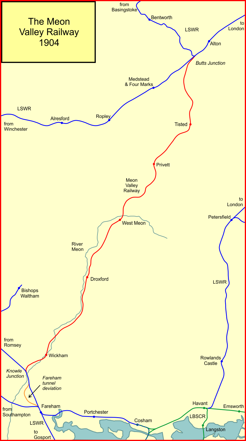
The Meon Valley Railway was a cross-country railway in Hampshire, England, that ran for 22 miles (36 km) between Alton and Fareham, closely following the course of the River Meon. At its northern (Alton) end, it joined with the Alton Line from London. It was conceived as an additional main line to the area around Gosport, and it was opened in 1903. It never fulfilled its planned potential, and remained a local line through sparsely populated agricultural areas, and it closed to passenger services in 1955; some local goods services continued until total closure in 1968. The name does not refer to an independent company; it was constructed and run by the London and South Western Railway (LSWR). History Background By the last decade of the nineteenth century, the railway map of Great Britain was already mature, and there were few gaps waiting to be filled by speculators. In 1852 the London and South Western Railway had reached Alton, from Brookwood on the London to Southampto ... [...More Info...] [...Related Items...] OR: [Wikipedia] [Google] [Baidu] |
Hampshire
Hampshire (, ; abbreviated to Hants) is a ceremonial and non-metropolitan county in western South East England on the coast of the English Channel. Home to two major English cities on its south coast, Southampton and Portsmouth, Hampshire is the 9th-most populous county in England. The county town of Hampshire is Winchester, located in the north of the county. The county is bordered by Dorset to the south-west, Wiltshire to the north-west, Berkshire to the north, Surrey to the north-east, and West Sussex to the south east. The county is geographically diverse, with upland rising to and mostly south-flowing rivers. There are areas of downland and marsh, and two national parks: the New Forest and part of the South Downs, which together cover 45 per cent of Hampshire. Settled about 14,000 years ago, Hampshire's recorded history dates to Roman Britain, when its chief town was Venta Belgarum (now Winchester). The county was recorded in Domesday Book as divided into 44 ... [...More Info...] [...Related Items...] OR: [Wikipedia] [Google] [Baidu] |
Basingstoke And Alton Light Railway
The Basingstoke and Alton Light Railway was opened in 1901, by the London and South Western Railway. It was the first English railway authorised under Light Railway legislation. It ran through unpromising, lightly populated terrain, and was probably built only to exclude competitors from building a line in the area. It had steep gradients and a line speed limit of 20 mph, later raised to 25 mph. It never attracted much business and the hoped-for through traffic never materialised. When the War Office demanded recovered track for laying in France, during the First World War, the LSWR closed the line and lifted the track, in 1917. After the war, local pressure mounted to reinstate the railway; this was resisted by the Southern Railway, which had taken over from the LSWR. The SR had no wish to spend considerable sums to reopen a railway that had lost money and had no positive prospects. A House of Lords Committee effectively forced the SR to resume operation, which it did in 192 ... [...More Info...] [...Related Items...] OR: [Wikipedia] [Google] [Baidu] |
Chalk
Chalk is a soft, white, porous, sedimentary carbonate rock. It is a form of limestone composed of the mineral calcite and originally formed deep under the sea by the compression of microscopic plankton that had settled to the sea floor. Chalk is common throughout Western Europe, where deposits underlie parts of France, and steep cliffs are often seen where they meet the sea in places such as the Dover cliffs on the Kent coast of the English Channel. Chalk is mined for use in industry, such as for quicklime, bricks and builder's putty, and in agriculture, for raising pH in soils with high acidity. It is also used for " blackboard chalk" for writing and drawing on various types of surfaces, although these can also be manufactured from other carbonate-based minerals, or gypsum. Description Chalk is a fine-textured, earthy type of limestone distinguished by its light color, softness, and high porosity. It is composed mostly of tiny fragments of the calcite shells ... [...More Info...] [...Related Items...] OR: [Wikipedia] [Google] [Baidu] |
Farringdon, Hampshire
Farringdon is a village in the East Hampshire district of Hampshire in England. The village is 2.8 miles (4.5 km) south of Alton, on the A32 road, close to a source of the River Wey. The village has two parts, the larger being Upper Farringdon. Lower Farringdon is on the Alton to Gosport road, the A32. The 2001 census predicted a population for Farringdon Parish by 2006 of 495 increasing to 664 at the 2011 Census . The northern of the River Wey's two sources rises in countryside close to Farringdon (Grid Reference: SU707394). History Archaeological finds in the village include a Bronze Age beaker (found in September 1938) with a cruciform design on the base, of which only two examples are known; and a Roman coin, a Sestertius of Trajan (found in 1936). Both are now in Alton Museum. Farringdon was listed in the Domesday Book as Ferendone; the word means fern-covered hill. The village has a Norman church and a number of pre-18th Century houses. Lewis Cage, as lord of th ... [...More Info...] [...Related Items...] OR: [Wikipedia] [Google] [Baidu] |
West Meon
West Meon is a village and civil parish in Hampshire, England, with a population of 749 people at the 2011 census. Geography It is north-west of East Meon, on the headwaters of the River Meon. Its closest town is Petersfield which is to the east. There are a number of walks around the village and surrounding hills along the South Downs Way and the bridleway provided by the, now defunct Meon Valley Railway Line, which leads south from West Meon to Wickham. History A charter of 932 in which King Æthelstan granted West Meon to the thegn Æthelweard includes a detailed account of the boundary of the estate which almost coincides with the boundary of the modern parish of West Meon. The Manor of West Meon was listed in the Domesday Book as owned by the Bishop of Winchester. A charter of 1205 confirmed the grant of land to the Prior and Convent of St. Swithun, Winchester, in whose hands it remained until the Dissolution of the Monasteries. In 1541 the manor was granted to th ... [...More Info...] [...Related Items...] OR: [Wikipedia] [Google] [Baidu] |
West Meon Tunnel South Portal
West or Occident is one of the four cardinal directions or points of the compass. It is the opposite direction from east and is the direction in which the Sun sets on the Earth. Etymology The word "west" is a Germanic word passed into some Romance languages (''ouest'' in French, ''oest'' in Catalan, ''ovest'' in Italian, ''oeste'' in Spanish and Portuguese). As in other languages, the word formation stems from the fact that west is the direction of the setting sun in the evening: 'west' derives from the Indo-European root ''*wes'' reduced from ''*wes-pero'' 'evening, night', cognate with Ancient Greek ἕσπερος hesperos 'evening; evening star; western' and Latin vesper 'evening; west'. Examples of the same formation in other languages include Latin occidens 'west' from occidō 'to go down, to set' and Hebrew מַעֲרָב maarav 'west' from עֶרֶב erev 'evening'. Navigation To go west using a compass for navigation (in a place where magnetic north is the same dire ... [...More Info...] [...Related Items...] OR: [Wikipedia] [Google] [Baidu] |
East Tisted Railway Station
East or Orient is one of the four cardinal directions or points of the compass. It is the opposite direction from west and is the direction from which the Sun rises on the Earth. Etymology As in other languages, the word is formed from the fact that east is the direction where the Sun rises: ''east'' comes from Middle English ''est'', from Old English ''ēast'', which itself comes from the Proto-Germanic *''aus-to-'' or *''austra-'' "east, toward the sunrise", from Proto-Indo-European *aus- "to shine," or "dawn", cognate with Old High German ''*ōstar'' "to the east", Latin ''aurora'' 'dawn', and Greek ''ēōs'' 'dawn, east'. Examples of the same formation in other languages include Latin oriens 'east, sunrise' from orior 'to rise, to originate', Greek ανατολή anatolé 'east' from ἀνατέλλω 'to rise' and Hebrew מִזְרָח mizraḥ 'east' from זָרַח zaraḥ 'to rise, to shine'. '' Ēostre'', a Germanic goddess of dawn, might have been a personification ... [...More Info...] [...Related Items...] OR: [Wikipedia] [Google] [Baidu] |
Plymouth
Plymouth () is a port city status in the United Kingdom, city and unitary authority in South West England. It is located on the south coast of Devon, approximately south-west of Exeter and south-west of London. It is bordered by Cornwall to the west and south-west. Plymouth's early history extends to the Bronze Age when a first settlement emerged at Mount Batten. This settlement continued as a trading post for the Roman Empire, until it was surpassed by the more prosperous village of Sutton founded in the ninth century, now called Plymouth. In 1588, an English fleet based in Plymouth intercepted and defeated the Spanish Armada. In 1620, the Pilgrim Fathers departed Plymouth for the New World and established Plymouth Colony, the second English settlement in what is now the United States of America. During the English Civil War, the town was held by the Roundhead, Parliamentarians and was besieged between 1642 and 1646. Throughout the Industrial Revolution, Plymouth grew as a ... [...More Info...] [...Related Items...] OR: [Wikipedia] [Google] [Baidu] |
West Meon
West Meon is a village and civil parish in Hampshire, England, with a population of 749 people at the 2011 census. Geography It is north-west of East Meon, on the headwaters of the River Meon. Its closest town is Petersfield which is to the east. There are a number of walks around the village and surrounding hills along the South Downs Way and the bridleway provided by the, now defunct Meon Valley Railway Line, which leads south from West Meon to Wickham. History A charter of 932 in which King Æthelstan granted West Meon to the thegn Æthelweard includes a detailed account of the boundary of the estate which almost coincides with the boundary of the modern parish of West Meon. The Manor of West Meon was listed in the Domesday Book as owned by the Bishop of Winchester. A charter of 1205 confirmed the grant of land to the Prior and Convent of St. Swithun, Winchester, in whose hands it remained until the Dissolution of the Monasteries. In 1541 the manor was granted to th ... [...More Info...] [...Related Items...] OR: [Wikipedia] [Google] [Baidu] |
Aldershot And Alton Lines Of The LSWR
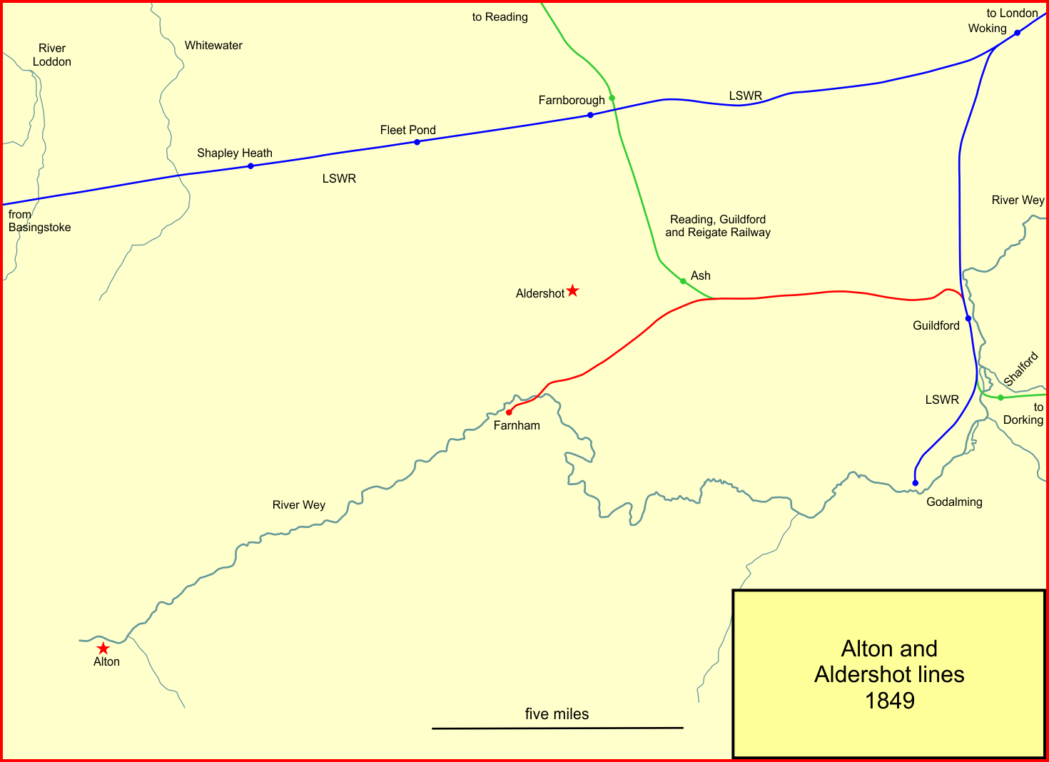
The Aldershot and Alton lines of the LSWR (the London and South Western Railway) were railways developed from 1849 onwards in the region in Surrey and Hampshire, England, between the Southampton main line and Guildford. First was a line from Guildford to Farnham, soon extended to Alton in 1852. The Reading, Guildford and Reigate Railway, an affiliate of the South Eastern Railway (SER), used part of that line by running powers. When the Aldershot Garrison and associated camps opened, suddenly Aldershot had a large population, both civilian and military, and the LSWR built a line from Pirbright Junction, on the Southampton main line. As well as serving Aldershot, this line gave a more direct route from London. It opened in 1870. It was complemented by a short curve near Ash enabling trains from Guildford to reach Aldershot, opening in 1879. This formed an Aldershot loop that by-passed part of the original line, from Ash Junction through Tongham to Farnham Junction. Although ... [...More Info...] [...Related Items...] OR: [Wikipedia] [Google] [Baidu] |


%2C_Western_Negev%2C_Israel.jpg)

