|
Meltham
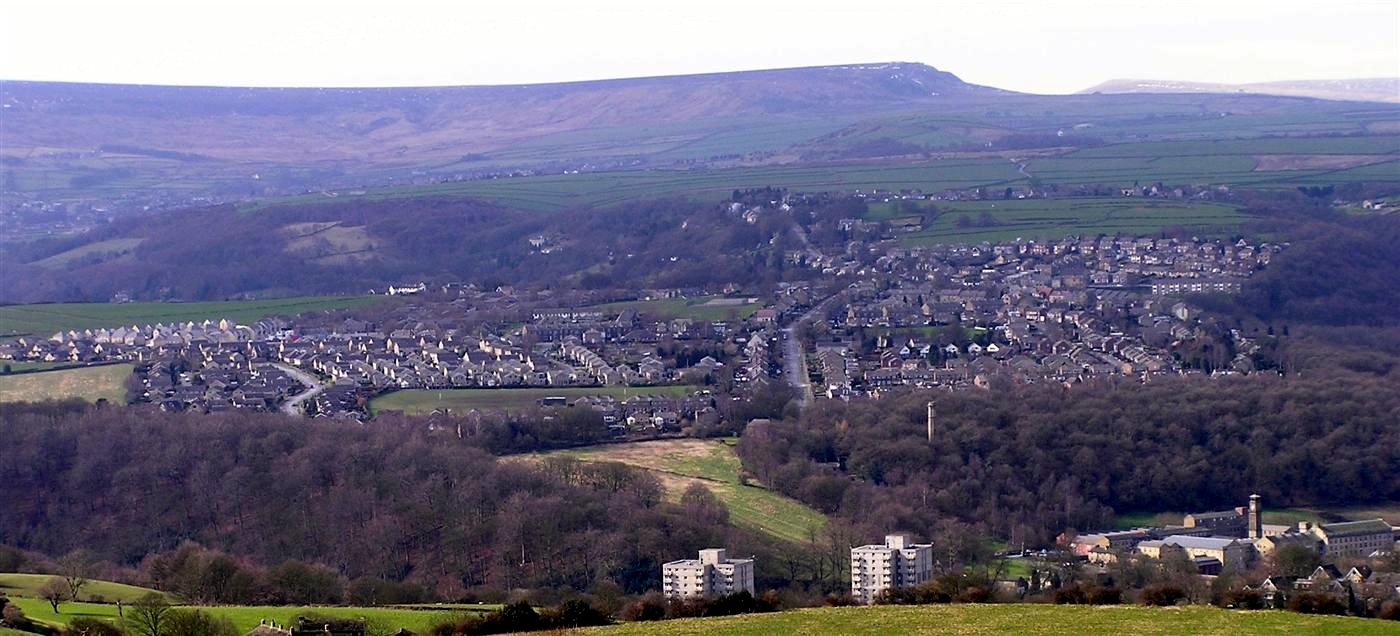
Meltham is a town and civil parish within the Metropolitan Borough of Kirklees, in West Yorkshire, England. It lies in the Holme Valley, below Wessenden Moor, four and a half miles south-west of Huddersfield on the edge of the Peak District National Park. It had a population of 8,089 at the 2001 census, which was estimated to have increased to 8,600 by 2005. The population assessed at the 2011 Census was 8,534. It has 12 elected council members who meet up around every 6 weeks. History The valley has been inhabited since pre-historic times and there are two Iron Age sites overlooking the town. In 1086, Meltham was recorded in the Domesday Book as a village in the hundred of Agbrigg and the county of Yorkshire although in 1086 the village had been laid waste. The town used to have a station on the Meltham branch line, which ran from Lockwood outside of Huddersfield. The line opened to passengers in 1869, closing in 1949, the it survived as a freight only line until the 1960s. ... [...More Info...] [...Related Items...] OR: [Wikipedia] [Google] [Baidu] |
Meltham Branch Line
The Meltham branch line is a disused railway line that ran for from Lockwood to Meltham, in West Yorkshire, England. The line was single track for its entire length. The last regular passenger service was on 21 May 1949. It closed completely on 3 April 1965. The route The route began just south of Lockwood station near Lockwood Viaduct at a junction with the Penistone Line and continued as follows: * Woodfield (Opened and closed June 1874 due to being on an unsafe gradient) * here is ''Butternab Tunnel'' (256 yards) * here is ''Netherton Tunnel'' (333 yards) * Netherton * * here is ''Healey House Tunnel'' (30 yards) * Meltham Mills Halt * Meltham Present day A new housing estate and a Morrisons supermarket have been built on the site of the Meltham station but much of the line remains. In 2004 a plan was proposed to convert much of the track bed to a cycle track to be known as the ''Meltham Greenway''. The first section of this opened in May 2008 between Station Roa ... [...More Info...] [...Related Items...] OR: [Wikipedia] [Google] [Baidu] |
Meltham Railway Station (England)
Meltham railway station was the terminus of the Meltham branch line from (Huddersfield) to Meltham, in the West Riding of Yorkshire, England. Traffic partially started in 1868, but became regular in July 1869. The station, and line, were opened by the Lancashire & Yorkshire Railway The Lancashire and Yorkshire Railway (L&YR) was a major British railway company before the 1923 Grouping. It was incorporated in 1847 from an amalgamation of several existing railways. It was the third-largest railway system based in northern ... (L&YR), later becoming part of the London Midland Scottish Railway. The station closed to passengers in 1949, though the branch remained open to freight until the 1960s. The railway station site is now the location of a supermarket. History The branch line to Meltham from Lockwood was opened in August 1868 by the Lancashire & Yorkshire Railway, but was closed soon afterwards owing to the collapse of an embankment. It re-opened to freight in February ... [...More Info...] [...Related Items...] OR: [Wikipedia] [Google] [Baidu] |
Kirklees
Kirklees is a local government district of West Yorkshire, England, governed by Kirklees Council with the status of a metropolitan borough. The largest town and administrative centre of Kirklees is Huddersfield, and the district also includes Batley, Birstall, West Yorkshire, Birstall, Cleckheaton, Denby Dale, Dewsbury, Heckmondwike, Holmfirth, Kirkburton, Marsden, West Yorkshire, Marsden, Meltham, Mirfield and Slaithwaite. Kirklees had a population of 422,500 in 2011; it is also the third largest metropolitan district in England by List of English districts by area, area size, behind Metropolitan Borough of Doncaster, Doncaster and City of Leeds, Leeds. History The borough was formed on 1 April 1974 by the provisions of the Local Government Act 1972 as part of a reform of local government in England. Eleven former local government districts were Amalgamation (politics), merged: the county boroughs of Huddersfield and Dewsbury, the municipal boroughs of Batley and Spenborough a ... [...More Info...] [...Related Items...] OR: [Wikipedia] [Google] [Baidu] |
Colne Valley (UK Parliament Constituency)
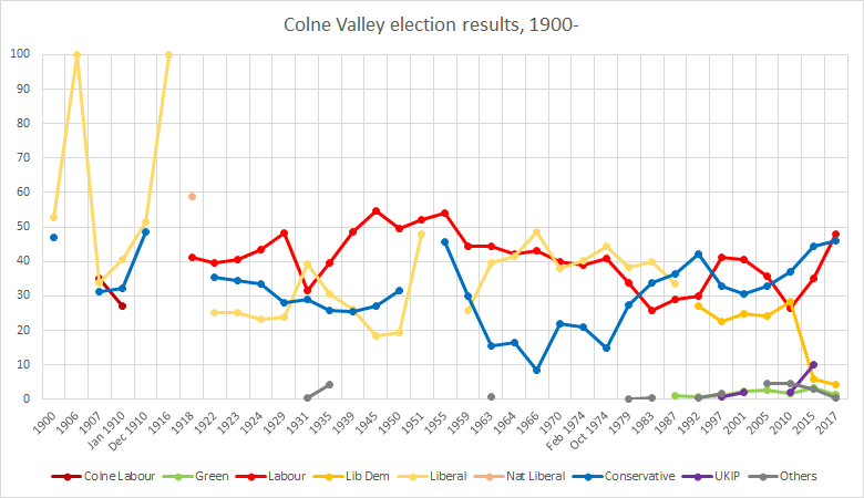
Colne Valley is a List of United Kingdom Parliament constituencies, constituency represented in the House of Commons of the United Kingdom, House of Commons of the Parliament of the United Kingdom, UK Parliament since 2019 by Jason McCartney (politician), Jason McCartney of the Conservative Party (UK), Conservative Party. Constituency profile The seat is named after the River Colne, West Yorkshire, Colne; one of three rivers so-named in the UK and one of three main rivers in the seat; its three main towns sit on hillsides and moorland and the local dwellings are mainly stone-built. A sizeable proportion of retirees live in the area, celebrated in the decades-long television comedy ''Last of the Summer Wine'', centred on Holmfirth in the seat. The wider Colne and Holme Valleys still retain some agriculture such as the Longley Farm dairy whose products are sold nationwide. The south-west of the constituency, bordering with Oldham and High Peak, Derbyshire, is within the Peak Di ... [...More Info...] [...Related Items...] OR: [Wikipedia] [Google] [Baidu] |
West Yorkshire
West Yorkshire is a metropolitan and ceremonial county in the Yorkshire and Humber Region of England. It is an inland and upland county having eastward-draining valleys while taking in the moors of the Pennines. West Yorkshire came into existence as a metropolitan county in 1974 after the reorganisation of the Local Government Act 1972 which saw it formed from a large part of the West Riding of Yorkshire. The county had a recorded population of 2.3 million in the 2011 Census making it the fourth-largest by population in England. The largest towns are Huddersfield, Castleford, Batley, Bingley, Pontefract, Halifax, Brighouse, Keighley, Pudsey, Morley and Dewsbury. The three cities of West Yorkshire are Bradford, Leeds and Wakefield. West Yorkshire consists of five metropolitan boroughs ( City of Bradford, Calderdale, Kirklees, City of Leeds and City of Wakefield); it is bordered by the counties of Derbyshire to the south, Greater Manchester to the south-west, ... [...More Info...] [...Related Items...] OR: [Wikipedia] [Google] [Baidu] |
Marsden, West Yorkshire
Marsden is a large village in the Metropolitan Borough of Kirklees, West Yorkshire, England. It is in the South Pennines close to the Peak District which lies to the south. The village is west of Huddersfield at the confluence of the River Colne and Wessenden Brook. It was an important centre for the production of woollen cloth. In 2020, the village had an estimated population of 3,768. History Marsden grew wealthy in the 19th century from the production of woollen cloth. It is still home to Bank Bottom Mill, later known as Marsden Mill, and home to John Edward Crowther Ltd, formerly one of the largest mills in Yorkshire. The Crowthers moved to Marsden in 1876, beginning a long and profitable association with cloth manufacturing in the town. During the 1930s Bank Bottom Mill covered an area of 14 acres, employed 680 looms, and provided employment for 1,900 workers. [...More Info...] [...Related Items...] OR: [Wikipedia] [Google] [Baidu] |
Holme Valley
Holme Valley is a large civil parish in the Metropolitan Borough of Kirklees in West Yorkshire, England. It has a population of 25,049 (2001 census), increasing to 34,680 for the two wards in the 2011 Census. Its administrative centre is in Holmfirth. Other sizeable settlements in the parish include, Brockholes, Honley and New Mill. It is named from the River Holme that runs through the parish. . The parish is the successor to the Holmfirth urban district. An urban district covering Holmfirth was created in 1894 by the Local Government Act 1894 and then in 1938, under a County Review Order, absorbed parts of the Holme, Honley, New Mill, South Crosland and Thurstonland and Farnley Tyas urban districts, keeping the name. Under the Local Government Act 1972 The Local Government Act 1972 (c. 70) is an Act of the Parliament of the United Kingdom that reformed local government in England and Wales on 1 April 1974. It was one of the most significant Acts of Parliam ... [...More Info...] [...Related Items...] OR: [Wikipedia] [Google] [Baidu] |
Honley
__NOTOC__ Honley is a large village in West Yorkshire, England. Historically part of the West Riding of Yorkshire, it is situated near to Holmfirth and Huddersfield, and on the banks of the River Holme in the Holme Valley. According to the 2011 Census it had a population of 6,474, a growth of 577 from the 2001 Census Community The annual Honley Agricultural Show takes place on the second Saturday of June. The show has used farmland between Honley and Meltham, and more recently farmland in Farnley Tyas. Honley has both female and male voice choirs. There are three schools in the village. Honley Infant and Nursery School for ages 3–7, Honley Junior School for ages 7–11 and Honley High School which after abolishing its sixth form college is now for ages 11–16. Transport Rail Honley railway station opened on 1 July 1850, on the Penistone Line. It connects the village to Huddersfield and Sheffield with an hourly service. Bus There are regular bus services to Huddersfiel ... [...More Info...] [...Related Items...] OR: [Wikipedia] [Google] [Baidu] |
Netherton, Huddersfield
Netherton is a village, near Huddersfield, in the Kirklees metropolitan borough of West Yorkshire, England. It is 2 miles (3 km) south-west of the town centre on the road to Meltham. Netherton together with South Crosland have a population of 3,702 according to the 2001 census. It is part of the Crosland Moor and Netherton ward of the Colne Valley The Colne Valley is a steep sided valley on the east flank of the Pennine Hills in the English county of West Yorkshire. It takes its name from the River Colne which rises above the town of Marsden and flows eastward towards Huddersfield. ... parliamentary constituency. It has a junior school and an infant school. It also has a junior football club who play at South Crosland Junior school and Hawkroyd bank. They were also the founder members of the Huddersfield & District Junior football league. It also has a 3 Team open age football team in the Huddersfield District League. Notable people * Ian Berry, artis ... [...More Info...] [...Related Items...] OR: [Wikipedia] [Google] [Baidu] |
Helme, West Yorkshire
Helme is a small village in the Kirklees district, in the county of West Yorkshire, England. It is near the town of Meltham and Blackmoorfoot Reservoir. Helme, constituted in 1858, was part of Almondbury parish in the 19th century. __TOC__ Amenities The local primary school is Helme Church of England Academy. Christ Church on Slades Lane, designed by James Pigott Pritchett James Pigott Pritchett (14 October 1789 – 23 May 1868) was an English architect. He lived in London and York and his practice stretched from Lincolnshire to the Scottish borders. Personal life Pritchett was born on 14 October 1789 to Char ... and consecrated in November 1859, is a Grade II listed building. Nearby Helme Hall, built in the late 19th century, is now a nursing and residential home for the elderly. See also * Listed buildings in Meltham References Villages in West Yorkshire Geography of Kirklees {{WestYorkshire-geo-stub ... [...More Info...] [...Related Items...] OR: [Wikipedia] [Google] [Baidu] |
Holmfirth
Holmfirth is a town in the Metropolitan Borough of Kirklees, West Yorkshire, England, on the A635 and A6024 in the Holme Valley, at the confluence of the River Holme and Ribble, south of Huddersfield and west of Barnsley. It mostly consists of stone-built cottages nestled in the Pennine hills. The boundary of the Peak District National Park is south-west of the town. Historically part of the West Riding of Yorkshire, Holmfirth was a centre for pioneering film-making by Bamforth & Co., which later switched to the production of saucy seaside postcards. Between 1973 and 2010, Holmfirth and the Holme Valley became well known as the filming location of the BBC's situation comedy '' Last of the Summer Wine''. History The name ''Holmfirth'' derives from Old English ''holegn'' ('holly'), in the name of Holme, West Yorkshire, compounded with Middle English ''frith'' ('wood'). It thus meant 'the woods at Holme'. The town originally grew up around a corn mill and bridge in t ... [...More Info...] [...Related Items...] OR: [Wikipedia] [Google] [Baidu] |
Peak District Boundary Walk
The Peak District Boundary Walk is a circular walking trail, starting and finishing at Buxton and broadly following the boundary of the Peak District, Britain's first national park. The route was developed by the Friends of the Peak District (a branch of the Campaign to Protect Rural England) and was launched on 17 June 2017. The Friends of the Peak District's founders, Gerald and Ethel Haythornthwaite, proposed the boundary of the Peak District National Park, which was subsequently established as the United Kingdom's first National Park in 1951. The route is waymarked with green markers and uses existing footpaths, tracks, quiet lanes, disused railway lines and a canal towpath. The start and finish is at the King's Head pub on Buxton Market Place, where a plaque has been installed by the Peak & Northern Footpaths Society (PNFS). The terrain covers open moorlands of the South Pennines, the limestone scenery of the Derbyshire Dales, woodlands, reservoirs and rural farming ... [...More Info...] [...Related Items...] OR: [Wikipedia] [Google] [Baidu] |


.jpg)


.jpg)
