|
Modum Municipality
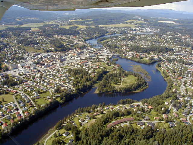
Modum is a municipality in Buskerud county, Norway. The administrative centre of the municipality is the town of Vikersund. The municipality of Modum was established on 1 January 1838 (see formannskapsdistrikt). The area has a long tradition of skiing with several famous skiers. Modum is home to one of the largest ski jumping hills in the world, Vikersundbakken which is situated in Heggen, outside Geithus. The hill record, established in 2017 is a jump of . General information Name The municipality (originally the parish) is named after the old ''Modum'' farm (Old Norse: ''Móðheimr''), since the first church was built here. The first element is ''móða'' which means "river" (here the Drammenselva river) and the last element is ''heimr'' which means "home", "homestead", or "farm". The name of the farm was later changed to ''Buskerud''. Coat-of-arms The coat-of-arms is from modern times. They were granted on 15 March 1985. The arms show three wavy silver lines “ party p ... [...More Info...] [...Related Items...] OR: [Wikipedia] [Google] [Baidu] |
Ringerike (traditional District)
Ringerike is a traditional district in Norway, commonly consisting of the municipalities Hole, Norway, Hole and Ringerike (municipality), Ringerike in Buskerud county. In older times, Ringerike had a larger range which went westward to the municipalities Krødsherad, Modum, and Sigdal, also in Buskerud. Ringerike has a rich history that is connected with one of the most notable kings in the history of Norway, the father of King Harald Fairhair Halfdan the Black, who subdued Gandalf Alfgeirsson, King of Alfheim and half of Vingulmork, and the Dagling clan. Gandalf was possibly the last king of Ringerike, whose name is given to the eponymous King Hring, son of Raum the Old (cf. Romerike), son of Nór (the eponymous ancestor of Norwegians), according to the Sagas of the ancient Northernlands, better known as the ''Orkneyinga saga''. It is possible that this, as the name suggests, was the legendary heartland of the House of Sigurd Hring and Ivar the Wide-Fathoming. There are also many ... [...More Info...] [...Related Items...] OR: [Wikipedia] [Google] [Baidu] |
Home
A home, or domicile, is a space used as a permanent or semi-permanent residence for one or more human occupants, and sometimes various companion animals. Homes provide sheltered spaces, for instance rooms, where domestic activity can be performed such as sleeping, preparing food, eating and hygiene as well as providing spaces for work and leisure such as remote working, studying and playing. Physical forms of homes can be static such as a house or an apartment, mobile such as a houseboat, trailer or yurt or digital such as virtual space. The aspect of 'home' can be considered across scales; from the micro scale showcasing the most intimate spaces of the individual dwelling and direct surrounding area to the macro scale of the geographic area such as town, village, city, country or planet. The concept of 'home' has been researched and theorized across disciplines – topics ranging from the idea of home, the interior, the psyche, liminal space, contested space to gende ... [...More Info...] [...Related Items...] OR: [Wikipedia] [Google] [Baidu] |
Øvre Eiker
Øvre Eiker is a municipality in Buskerud county, Norway. It is part of the traditional region of Eiker. The administrative centre of the municipality is the village of Hokksund. The old municipality of Eiker was divided into ''Øvre Eiker'' (upper Eiker) and '' Nedre Eiker'' (lower) on 1 July 1885. As of 2015, more employees worked for the unicipalgovernment and in the service sector, than in any other field of employment; even fewer—16 %—are employed in construction or in lectricalpower companies and water companies; 3%work in the manufacturing sector. General information Name The Old Norse form of the name was ''Eikjar''. The name is the plural form of ''eiki'' which means "oak wood". The meaning of ''Øvre Eiker'' is "(the) upper (part of) Eiker". (The municipality of Eiker was divided in 1885.) Coat-of-arms The coat-of-arms is from modern times. They were granted on 24 October 1981. The arms show three silver oak leaves and two acorns on a blue background. T ... [...More Info...] [...Related Items...] OR: [Wikipedia] [Google] [Baidu] |
Lier, Norway
Lier is a Municipalities of Norway, municipality in Buskerud Counties of Norway, county, Norway. The administrative centre of the municipality is the village of Lierbyen. The municipality of Lier was established on 1 January 1838 (see formannskapsdistrikt). The area Åssiden was transferred from Lier to the neighboring municipality of Drammen on 1 July 1951. Norway's longest indoor shopping center, Liertoppen, is located in Lierskogen. The newspaper ''Lierposten'' is published in Lier. General information Name The Old Norse form of the name was ''Líðir''. The name is the plural form of ''líð'' which means "hillside". Coat of arms The coat of arms and was designed by Hallvard Trætteberg and granted on 14 August 1970. The arms show five silver-colored apple blossoms on a red background. The area is well known for the production of various types of fruit, berries, vegetables, and flowers, so this was chosen as a symbol of the area's lush scenery and agriculture. Geograph ... [...More Info...] [...Related Items...] OR: [Wikipedia] [Google] [Baidu] |
Hole, Norway
Hole is a Municipalities of Norway, municipality in Buskerud Counties of Norway, county, Norway. It is part of the Districts of Norway, traditional region of Ringerike (traditional district), Ringerike. The administrative centre of the municipality is the village of Vik, Buskerud, Vik. Hole is located around lake Tyrifjorden and extends to the woodland around Oslo. The soil is fertile and suited to growing fruit, berries and other agricultural products. The municipality of Hole was established on 1 January 1838 (see formannskapsdistrikt). The annex of Tyristrand was separated from Hole on 1 July 1916 to become a municipality of its own. The municipality of Hole was merged into the neighboring municipality of Ringerike (municipality), Ringerike in 1964, however, this merger ended in 1977 when Hole was restored as a separate municipality. Infrastructure: the road (European route E16, E16) between Sandvika and Hønefoss has been Norway's most deadly, for the ten-year period that ende ... [...More Info...] [...Related Items...] OR: [Wikipedia] [Google] [Baidu] |
Ringerike (municipality)
Ringerike is a Municipalities of Norway, municipality in Buskerud Counties of Norway, county, Norway. It is part of the Districts of Norway, traditional region of Ringerike (traditional district), Ringerike. The administrative centre of the municipality is the List of cities in Norway, town of Hønefoss. The municipality of Ringerike was created on 1 January 1964 after the merger of the town of Hønefoss and the rural municipalities of Hole, Norway, Hole, Norderhov, Tyristrand, and Ådal. However, the area of Hole was removed from the municipality of Ringerike on 1 January 1977 to become a separate municipality once again. The historic area of Ringerike included not just the modern municipality of Ringerike but also Hole and Krødsherad, Modum, and Sigdal. General information Etymology The Old Norse language, Norse form of this name was ''Hringaríki''. The first element is (probably) the genitive plural of ''hringir'', the name of an old Germanic peoples, Germanic tribe. The la ... [...More Info...] [...Related Items...] OR: [Wikipedia] [Google] [Baidu] |
Krødsherad
Krødsherad (''Krødsherad kommune'') is a Municipalities of Norway, municipality in Buskerud Counties of Norway, county, Norway. The administrative centre of the municipality is the village of Noresund. The municipality of Krødsherad was established when it was separated from the municipality of Sigdal on 1 January 1901. General information Name The Old Norse form of the name was ''Krœðisherað''. The first element is the genitive case of the name of the lake Krøderen (lake), Krøderen, the last element is ''herað'' meaning "district". Prior to 1918, the name was spelled ''Krødsherred''. Coat-of-arms The Coat of arms, coat-of-arms is from modern times. They were granted on 11 September 1981. The arms are supposedly canting arms. In older times, the name, ''Krødsherad'', was commonly misunderstood as the word ''kross'' meaning "cross" or the area where two valleys crossed. Thus the saltire cross was taken as a symbol in the arms. New insights, however, derive the name f ... [...More Info...] [...Related Items...] OR: [Wikipedia] [Google] [Baidu] |
Blaafarveværket
Blaafarveværket, or the Blue Colour Works, was a mining and industrial company located at Åmot in Modum in Buskerud, Norway, which existed from 1776 to 1898, and which was Norway's largest mining company in the first half of the 19th century. The works mined cobalt ore and manufactured by smelting blue cobalt glass ( smalt) and cobalt blue (cobalt aluminate) pigment. It is currently a large open-air industrial museum and an art gallery; it is the largest and best preserved mine museum in Europe, and one of Norway's most visited attractions."Ingen sommer uten Blaafarveværket," ''Byavisa Drammen'', 21 June 2017 The company was founded as the Royal Blue Colour Works by King Christian VII in 1776 and was one of the few companies with lasting significance from the age of mercantilism, played an important role in Norwegian trade with Denmark, the Netherlands and the Far East and had a decisive impact on the Norwegian economy in the period around 1814. In 1822 the company was sol ... [...More Info...] [...Related Items...] OR: [Wikipedia] [Google] [Baidu] |
Blue
Blue is one of the three primary colours in the RYB color model, RYB colour model (traditional colour theory), as well as in the RGB color model, RGB (additive) colour model. It lies between Violet (color), violet and cyan on the optical spectrum, spectrum of visible light. The term ''blue'' generally describes colours perceived by humans observing light with a dominant wavelength that's between approximately 450 and 495 nanometres. Most blues contain a slight mixture of other colours; Azure (color), azure contains some green, while ultramarine contains some violet. The clear daytime sky and the deep sea appear blue because of an optical effect known as Rayleigh scattering#Cause of the blue colour of the sky, Rayleigh scattering. An optical effect called the Tyndall effect explains Eye color#Blue, blue eyes. Distant objects appear more blue because of another optical effect called aerial perspective. Blue has been an important colour in art and decoration since ancient t ... [...More Info...] [...Related Items...] OR: [Wikipedia] [Google] [Baidu] |
Simoa
Simoa is the name of a river which flows through the municipalities of Sigdal and Modum in Buskerud County, Norway. Location The Simoa river runs from Lake Soneren through the municipality of Sigdal in a south-easterly course until it flows into Drammenselva at Åmot in Modum. The river begins a few miles north of Lake Haglebuvatna where it is initially known as the Haglebu, later becoming the Eggedøla as it flows through the valley of Eggedal. Lake Soneren lies at an elevation of . The drainage basin of the Simoa covers . Haugfoss waterfall at Blaafarveværket in Modum, has been used as a motif for many artists throughout history. Notable examples include ''Winter at Simoa River'' which was painted during 1883 by Norwegian artist Frits Thaulow. It was developed for hydroelectric power by Midt Nett Buskerud AS, the utility company owned by Modum and Sigdal municipalities. Haugfoss kraftverk was constructed in 1937 and has a capacity of 3.6 MW. Horga, the tributary ... [...More Info...] [...Related Items...] OR: [Wikipedia] [Google] [Baidu] |
Snarumselva
Snarumselva is a river in Buskerud county, Norway. It flows north to south from Krøderen, a lake in Krødsherad municipality, to Geithus, a village in Modum municipality, where it joins the Drammenselva river. The total length of Snarumselva is about and the total altitude loss is about . There are two hydroelectric power plants along Snarumselva, both located on natural waterfalls A waterfall is any point in a river or stream where water flows over a vertical drop or a series of steep drops. Waterfalls also occur where meltwater drops over the edge of a tabular iceberg or ice shelf. Waterfalls can be formed in several .... The first is Ramfoss Power Plant, located on Ramfoss approximately south of the head of the river at Krøderen. The second, Kaggefoss Power Plant, is located on Kaggefoss, approximately two kilometres north of the terminus at Geithus. The portion of the river that runs from Kaggefoss to the terminus at Geithus is also sometimes called Kista. Ramfo ... [...More Info...] [...Related Items...] OR: [Wikipedia] [Google] [Baidu] |
Division Of The Field
In heraldry, the field (heraldry), field (background) of a escutcheon (heraldry), shield can be divided into more than one area, or subdivision, of different tincture (heraldry), tinctures, usually following the lines of one of the ordinary (heraldry), ordinaries and carrying its name (e.g. a shield divided in the shape of a Chevron (heraldry), chevron is said to be parted "per chevron"). Shields may be divided this way for ''differencing'' (to avoid conflict with otherwise similar coats of arms) or for purposes of ''Heraldry#Marshalling, marshalling'' (combining two or more coats of arms into one), or simply for style. The lines that divide a shield may not always be straight, and there is a system of terminology for describing patterned lines, which is also shared with the heraldic ordinaries. French heraldry takes a different approach in many cases from the one described in this article. Common divisions of the field Common partitions of the field are: * ''parted'' (or '' ... [...More Info...] [...Related Items...] OR: [Wikipedia] [Google] [Baidu] |


