|
Magahi
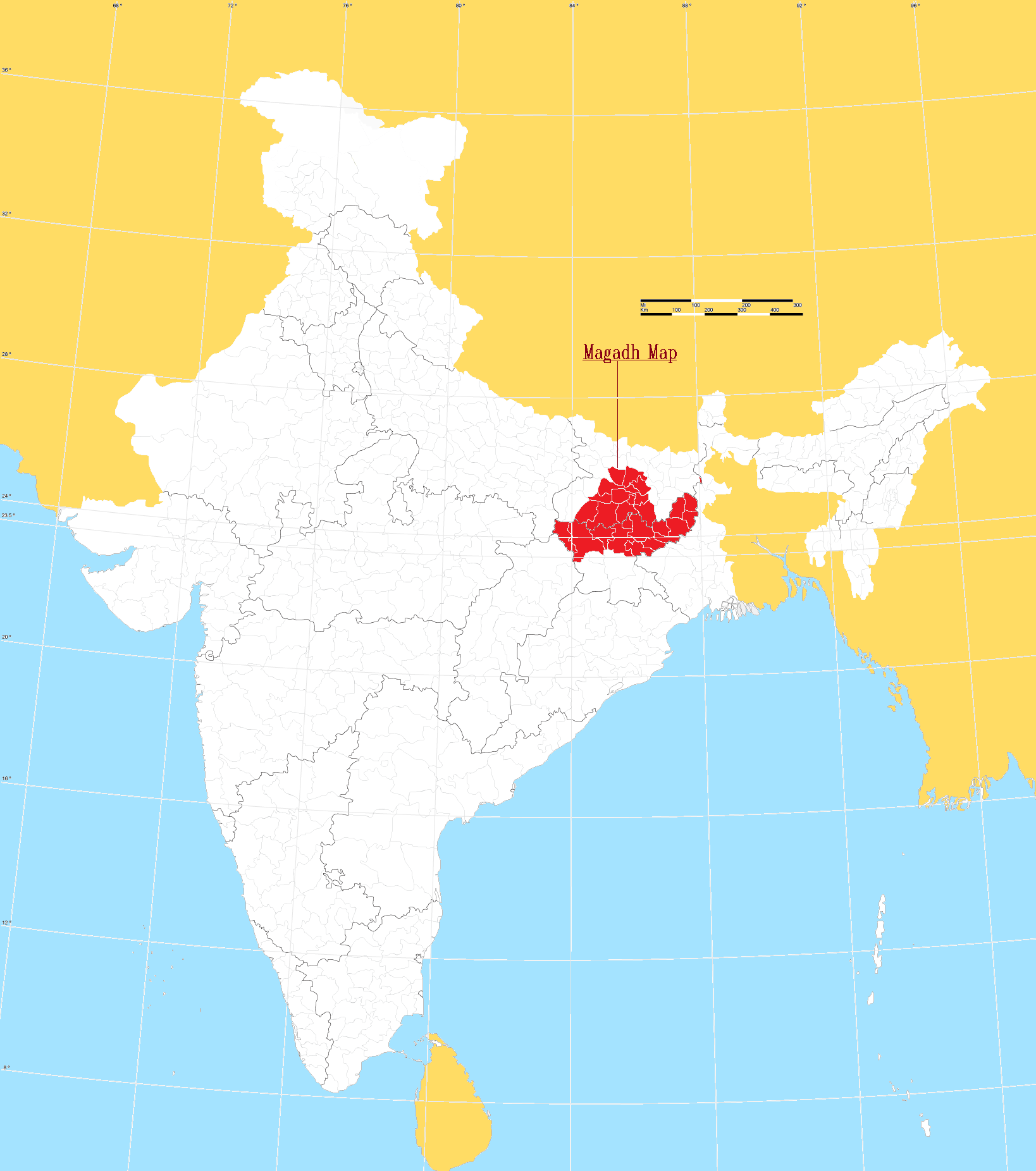
Magahi (), also known as Magadhi (), is an Indo-Aryan language spoken in Bihar, Jharkhand and West Bengal states of eastern India, and in the Terai region of Nepal. Magadhi Prakrit was the ancestor of Magahi, from which the latter's name derives. It has a very rich and old tradition of folk songs and stories. It is spoken in approximately twelve districts of Bihar ( Gaya, Nalnda, Patna, Jehanabad, Aurangabad, Nalanda, Sheikhpura, Nawada, Lakhisarai, Arwal, Jamui and in some parts of Banka), twelve districts of Jharkhand ( Hazaribag, Palamu, Chatra, Koderma, Jamtara, Bokaro, Dhanbad, Giridih, Deoghar, Garhwa, Latehar, Chatra) and in West Bengal's Malda district. Magahi derived from the ancient Magadhi Prakrit, which was created in the ancient kingdom of Magadha, the core of which was the area south of the Ganges and east of Son River. Though the number of speakers in Magahi is about 12.7 million, it has not been constitutionally recognised in India. In ... [...More Info...] [...Related Items...] OR: [Wikipedia] [Google] [Baidu] |
Magahi People
The culture of Magadha (region), Magadh is rich with its distinct language, folk songs and festivals. In ancient period it was known as Magadha (Mahajanapada), Magadha mahajanpada. The present-day Magadh region split between the states of Bihar and Jharkhand in India. The major language of the region is Magahi language, Magahi. Language The Magahi language is mainly spoken in south Bihar and parts of Jharkhand. It is in the Bihari languages, Bihari group of Indo-Aryan languages. Around 12 million people speak Magahi as an native language according to the 2011 census of India. It is spoken in eleven districts of Bihar (Gaya, India, Gaya, Patna, Jehanabad, Aurangabad, Bihar, Aurangabad, Nalanda, Nawada, Sheikhpura, Arwal, Lakhisarai, Jamui and some parts of Banka), and in eleven districts of Jharkhand (Hazaribag district, Hazaribag, Palamu, Garhwa, Deoghar, Chatra district, Chatra, Koderma district, Koderma, Jamtara district, Jamtara, Bokaro district, Bokaro, Dhanbad district, Dhanb ... [...More Info...] [...Related Items...] OR: [Wikipedia] [Google] [Baidu] |
Bihari Languages
Bihari languages are a group of the Indo-Aryan languages. The Bihari languages are mainly spoken in the Indian states of Bihar, Jharkhand, Uttar Pradesh, and West Bengal, and also in Nepal.Brass, Paul R. (1974). ''Language, Religion and Politics in North India''. Cambridge University Press. The most widely spoken languages of the Bihari group are Bhojpuri, Magahi/ Khortha, Nagpuri and Maithili. Despite the large number of speakers of these languages, only Maithili has been constitutionally recognised in India, which gained constitutional status via the 92nd amendment to the Constitution of India, of 2003 (gaining assent in 2004). Both Maithili and Bhojpuri have constitutional recognition in Nepal. Bhojpuri-Awadhi-Magahi mix is also official in Fiji as Fiji Hindi. There are demands for including Bhojpuri and Magahi/Khortha in the 8th schedule of Indian constitution. In Bihar, Hindi is the language used for educational and official matters. These languages were legally a ... [...More Info...] [...Related Items...] OR: [Wikipedia] [Google] [Baidu] |
Jharkhand
Jharkhand (; ) is a States and union territories of India, state in East India, eastern India. The state shares its border with the states of West Bengal to the east, Chhattisgarh to the west, Uttar Pradesh to the northwest, Bihar to the north and Odisha to the south. It is the List of states and territories of India by area, 15th largest state by area, and the List of states and union territories of India by population, 14th largest by population. Hindi is the official language of the state. The city of Ranchi is its capital and Dumka its sub-capital. The state is known for its waterfalls, hills and holy places; Baidyanath Temple, Baidyanath Dham, Parasnath, Maa Dewri Temple, Dewri and Rajrappa are major religious sites. Jharkhand is primarily rural, with about 24% of its population living in cities as of 2011. Jharkhand suffers from what is sometimes termed a resource curse: it accounts for more than 40% of Mining in India, India's mineral production but 39.1% of its populati ... [...More Info...] [...Related Items...] OR: [Wikipedia] [Google] [Baidu] |
Bihar
Bihar ( ) is a states and union territories of India, state in Eastern India. It is the list of states and union territories of India by population, second largest state by population, the List of states and union territories of India by area, 12th largest by area, and the List of Indian states and union territories by GDP, 14th largest by GDP in 2024. Bihar borders Uttar Pradesh to its west, Nepal to the north, the northern part of West Bengal to the east, and Jharkhand to the south. Bihar is split by the river Ganges, which flows from west to east. On 15 November 2000, a large chunk of southern Bihar was ceded to form the new state of Jharkhand. Around 11.27% of Bihar's population live in urban areas as per a 2020 report. Additionally, almost 58% of Bihari people, Biharis are below the age of 25, giving Bihar the highest proportion of young people of any Indian state. The official language is Hindi, which shares official status alongside that of Urdu. The main native languag ... [...More Info...] [...Related Items...] OR: [Wikipedia] [Google] [Baidu] |
Aurangabad District, Bihar
Aurangabad district is one of the thirty-eight districts of Bihar state, India. It is currently a part of the Red Corridor. Aurangabad is also called "Chittorgarh" of Bihar because the number of Suryavanshi Rajputs is very high here. Aurangabad played a major role in the Indian independence struggle, and is also the birthplace of eminent nationalist & first Deputy Chief Minister of state, Bihar Vibhuti Dr. Anugrah Narayan Sinha, a participant of Champaran Satyagraha who is regarded among makers of modern independent Bihar. Geography Aurangabad district occupies an area of , comparatively equivalent to Russia's Vaygach Island. Aurangabad town is the administrative headquarters of this district. Aurangabad district is a part of Magadh division. Aurangabad became a fully-fledged district when it was split from the Gaya district in 1972. Aurangabad celebrates its formation day on every 26 January . Economy In 2006, the Indian government named Aurangabad one of the country's 2 ... [...More Info...] [...Related Items...] OR: [Wikipedia] [Google] [Baidu] |
Arwal District
Arwal district is one of the thirty-eight districts of Bihar state, India, and Arwal town is the administrative headquarters of this district. It was earlier part of Jehanabad district. As of 2001 it is the third least populous district of Bihar (out of 38), after Sheikhpura and Sheohar. Arwal District is very small district of Bihar. Most of people are engaged in primary sector. History Recent events There was a massacre of Dalit people, who were considered to be naxal supporters by Ranvir Sena-a private militia of dominant Bhumihar caste, at Laxmanpur Bathe in 1997. This massacre was in response of capturing land belonging to upper caste people and killing of Bhumihars in various massacre like Bara massacre and Senari massacre by Naxalite, most of the members of naxal cadres being Dalits. It was a part of the Red Corridor. Geography Arwal district occupies an area of , comparatively equivalent to Canada's Foley Island. Hydrology Arwal is the unique district of Bihar ... [...More Info...] [...Related Items...] OR: [Wikipedia] [Google] [Baidu] |
Kaithi
Kaithi (), also called Kayathi (), Kayasthi (), or Kayastani, is a Brahmic script historically used across parts of Northern and Eastern India. It was prevalent in regions corresponding to modern-day Uttar Pradesh, Bihar, and Jharkhand. The script was primarily utilized for legal, administrative, and private records and was adapted for a variety of Indo-Aryan languages, including Angika, Awadhi language, Awadhi, Bhojpuri language, Bhojpuri, Hindustani language, Hindustani, Maithili language, Maithili, Magahi language, Magahi, and Nagpuri language, Nagpuri. Etymology The name Kaithi script is derived from the term Chitraguptavanshi Kayastha, Kayastha, a social group, socio-professional group historically linked to writing, record-keeping and administration. This community served in royal courts and later in British colonial administration, maintaining revenue records, legal documents, title deeds, and general correspondence. The script they utilized was thus named Kaithi, r ... [...More Info...] [...Related Items...] OR: [Wikipedia] [Google] [Baidu] |
Devanagari
Devanagari ( ; in script: , , ) is an Indic script used in the Indian subcontinent. It is a left-to-right abugida (a type of segmental Writing systems#Segmental systems: alphabets, writing system), based on the ancient ''Brāhmī script, Brāhmī'' script. It is one of the official scripts of India, official scripts of India and Nepal. It was developed in, and was in regular use by, the 8th century CE. It had achieved its modern form by 1000 CE. The Devanāgarī script, composed of 48 primary characters, including 14 vowels and 34 consonants, is the fourth most widely List of writing systems by adoption, adopted writing system in the world, being used for over 120 languages, the most popular of which is Hindi (). The orthography of this script reflects the pronunciation of the language. Unlike the Latin alphabet, the script has no concept of letter case, meaning the script is a unicase, unicameral alphabet. It is written from left to right, has a strong preference for symmetri ... [...More Info...] [...Related Items...] OR: [Wikipedia] [Google] [Baidu] |
Magadha (region)
Magadha was a region and kingdom in ancient India, based in the eastern Ganges Plain. It was one of the sixteen Mahajanapadas during the Second Urbanization period. The region was ruled by several dynasties, which overshadowed, conquered, and incorporated the other Mahajanapadas. Magadha played an important role in the development of Jainism and Buddhism and formed the core of the Maurya Empire (ca. 320–185 BCE). Geography The territory of the Magadha kingdom proper before its expansion was bounded to the north, west, and east respectively by the Gaṅgā, Son, and Campā rivers, and the eastern spurs of the Vindhya mountains formed its southern border. The territory of the initial Magadha kingdom thus corresponded to the modern-day Patna and Gaya districts of the Indian state of Bihar. The region of Greater Magadha also included neighbouring regions in the eastern Gangetic plains and had a distinct culture and belief. History Vedic period (semi-legendary) (ca. 1700 B ... [...More Info...] [...Related Items...] OR: [Wikipedia] [Google] [Baidu] |
Gaya District
} Gaya district is one of the thirty-eight districts of the Indian state of Bihar. It was officially established on 3 October 1865. The district has a common boundary with the state of Jharkhand to the south. Gaya city is both the district headquarters and the second-largest city in Bihar. History Gaya finds mention in the Hindu epics Ramayana and Mahabharata. Rama, along with Sita and Lakshmana, are stated to have visited Gaya for offering '' pinda-dana'' to their father Dasharatha. In the Mahabharata, the place has been identified as Gayapuri. In the Vayu Purana, it is stated that Gaya was the name of a demon (asura) whose body became pious after he performed rigid penance and secured blessings from Vishnu. It was said that the Gayasura's body would continue to be known as Gaya Kshetra. Gaya has experienced the rise and fall of many dynasties in the Magadha Region. From the 6th century BC to the 18th century AD, about 2300–2400 years, Gaya has been occupying an impor ... [...More Info...] [...Related Items...] OR: [Wikipedia] [Google] [Baidu] |
East India
East India is a region consisting of the Indian states of Bihar, Jharkhand, Odisha and West Bengal and also the union territory of the Andaman and Nicobar Islands. The states of Bihar and West Bengal lie on the Indo-Gangetic plain. Jharkhand is situated on the Chota Nagpur Plateau. Odisha lies on the Eastern Ghats and the Deccan Plateau. West Bengal's capital Kolkata is the largest city of this region. The Kolkata Metropolitan Area is the country's third largest metropolitan region. The region is bounded by Bhutan, Nepal and the state of Sikkim in the north, the states of Uttar Pradesh and Chhattisgarh on the west, the state of Andhra Pradesh in the south and the country of Bangladesh in the east. It is also bounded by the Bay of Bengal in the south-east. It is connected to the Seven Sister States of Northeast India by the narrow Siliguri Corridor in the north east of West Bengal. East India has the fourth-largest gross domestic product of all Indian regions. The regio ... [...More Info...] [...Related Items...] OR: [Wikipedia] [Google] [Baidu] |
Nalanda District
Nalanda district is one of the thirty-eight Districts of Bihar, districts of the state of Bihar in India. Bihar Sharif is the administrative headquarters of this district. The districts is home to the ancient Nalanda Mahavihara a UNESCO World Heritage Site. Nalanda is located in the Magadh region of southern Bihar. In Jainism * The 24th Jainism, Jaina Tirthankara Mahavira, ''Mahāvīra'' is said to have spent 'many Chaturmasya, ''Cāturmāsyas'' (rainy seasons)' at ''Nālandā''. Canonical scriptures of the ''Śvetāmbara'' sect also mention that ''Nālandā'' was known by other names such as ''Nālandāpada'' and ''Nālandā Sanniveśa''. The texts further highlight that it was a suburb of ''Rajgir, Rājagṛha''. ''Mahāvīra'' is said to have had met ''Makkhali Gosala, Makkhali-gosāla'', the leader of the Ājīvika, ''Ājīvakas'', for the first time at ''Nālandā''. * Jaina tradition records that some of ''Mahāvīra's Ganadhara, Gaṇadharas'' (disciples), namely ''Gautama ... [...More Info...] [...Related Items...] OR: [Wikipedia] [Google] [Baidu] |


