|
Mactan Island
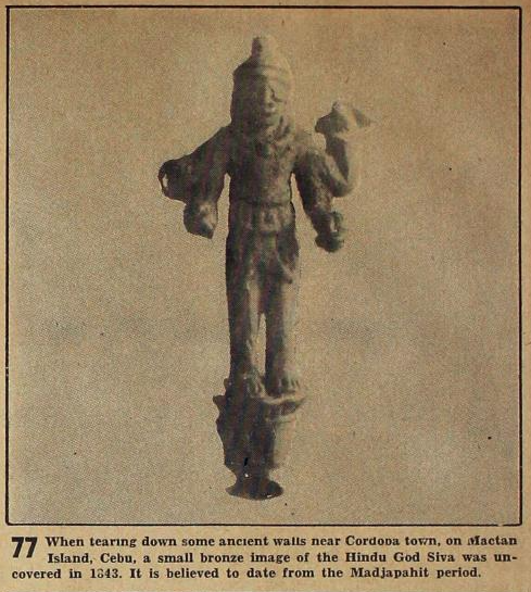
Mactan is a densely populated island located a few kilometers (~1 mile) east of Cebu Island in the Philippines. The island is part of Cebu province and it is divided into the city of Lapu-Lapu and the municipality of Cordova. The island is separated from Cebu by the Mactan Channel which is presently crossed by three bridges: the Cebu–Cordova Link Expressway (CCLEX), the Mactan–Mandaue Bridge, and the Marcelo Fernan Bridge. The island covers some and has a population of 527,071 as of 2020, making it the nation's most densely populated island. Along with Olango Island Group, the isles are administered by a city and a municipality covering . Mactan–Cebu International Airport is located on the island. Etymology The modern name Mactan descended from an earlier form, ''Manctan''. However, evidence of this earlier form is scant as, even as early as the 17th century, the island was already named Mactan. This form is attested in the original copy of the Philippine Declara ... [...More Info...] [...Related Items...] OR: [Wikipedia] [Google] [Baidu] |
Visayas
The Visayas ( ), or the Visayan Islands (Bisayan languages, Visayan: ''Kabisay-an'', ; Filipino language, Filipino: ''Kabisayaan'' ), are one of the three Island groups of the Philippines, principal geographical divisions of the Philippines, along with Luzon and Mindanao. Located in the central part of the archipelago, it consists of several islands, primarily surrounding the Visayan Sea, although the Visayas are also considered the northeast extremity of the entire Sulu Sea. Its inhabitants are predominantly the Visayan peoples. The major islands of the Visayas are Panay, Negros, Cebu Island, Cebu, Bohol Island, Bohol, Leyte and Samar. The region may also include the provinces of Palawan, Romblon, and Masbate, whose populations identify as Visayan and whose languages are more closely related to other Visayan languages than to the major languages of Luzon. There are four administrative Regions of the Philippines, regions in the Visayas: Western Visayas (pop. 4.73 million), Neg ... [...More Info...] [...Related Items...] OR: [Wikipedia] [Google] [Baidu] |
Olango Island Group
The Olango Island Group is a group of islands found in the Central Visayas region of the Philippines. It comprises Olango island and 6 satellite islets namely: Caubian, Camungi, Caohagan, Gilutongan, Nalusuan, Pangan-an, and Sulpa. The island group has a total land area of approximately . It is divided under the jurisdiction of the city of Lapu-Lapu and the municipality of Cordova, Cebu. It lies east of Mactan and is a major tourist destination in Cebu. It is known for its wildlife sanctuary. The entire area is the first declared Ramsar Wetland Site in the Philippines, as recognized in 1994. Geography The Olango Group of islands consists of seven islands. Located east of Mactan Island, Olango Island and its satellite islets lies between the Cebu Strait to the south and the Camotes Sea to the north. To the west is the Hilutangan Channel (which separates it from Mactan Island) while to the east is the Olango Channel (which separates it from Bohol). Land area Olango Islands ... [...More Info...] [...Related Items...] OR: [Wikipedia] [Google] [Baidu] |
Export Processing Zone
A free-trade zone (FTZ) is a class of special economic zone. It is a geographic area where goods may be imported, stored, handled, manufactured, or reconfigured and re-exported under specific customs regulation and generally not subject to customs duty. Free trade zones are generally organized around major seaports, international airports, and national frontiers—areas with many geographic advantages for trade. Definition The World Bank defines free trade zones as "small, fenced-in, duty-free areas, offering warehousing, storage, and distribution facilities for trade, transshipment, and re-export operations". Free-trade zones can also be defined as labor-intensive manufacturing centers that involve the import of raw materials or components and the export of factory products, but this is a dated definition as more and more free-trade zones focus on service industries such as software, back-office operations, research, and financial services. Synonyms Free-trade zones ar ... [...More Info...] [...Related Items...] OR: [Wikipedia] [Google] [Baidu] |
Augustinians
Augustinians are members of several religious orders that follow the Rule of Saint Augustine, written about 400 A.D. by Augustine of Hippo. There are two distinct types of Augustinians in Catholic religious orders dating back to the 12th–13th centuries: * Various congregations of Canons Regular also follow the Rule of Saint Augustine, embrace the evangelical counsels and lead a semi-monastic life, while remaining committed to pastoral care appropriate to their primary vocation as priests. They generally form one large community which might serve parishes in the vicinity, and are organized into autonomous congregations. * Several orders of friars who live a mixed religious life of contemplation and apostolic ministry. The largest and most familiar is the Order of Saint Augustine (OSA), founded in 1244 and originally known as the Hermits of Saint Augustine (OESA). They are commonly known as the Austin Friars in England. Two other orders, the Order of Augustinian Recollects ... [...More Info...] [...Related Items...] OR: [Wikipedia] [Google] [Baidu] |
Poro Island
Poro Island (Filipino: Pulo ng Poro) is an island in the province of Cebu, located east of Cebu Island and west of Leyte Island. Two municipalities, Poro and Tudela, are located on Poro Island. It is one of the four Camotes Islands along with Pacijan Island, Ponson Island, and Tulang Island. The island is one of the early Pacific contact sites between the East and the West. Geography Bukilat Cave The island hosts various caves. One example is the Bukilat Cave which is a large natural cavern in the southeastern part of the island. Because of naturally formed piercings in its canopy, the interior is well illuminated. There are many stalactite and stalagmite formations in the cave. It was used as a shelter for Poro Island residents during the Japanese occupation of the Philippines during the World War II era. Waterfalls Busay and Pangunuron Falls are among the waterfalls in the island. Buho Rock Buho Rock is a hole in a cliff wall said to have been formed when a Spani ... [...More Info...] [...Related Items...] OR: [Wikipedia] [Google] [Baidu] |
Datu
''Datu'' is a title which denotes the rulers (variously described in historical accounts as chiefs, sovereign princes, and monarchs) of numerous Indigenous peoples throughout the Philippine archipelago. The title is still used today, though not as much as early Philippine history. It is a cognate of ''datuk'', ''dato'', and ''ratu'' in several other Austronesian languages. Overview In early Philippine history, ''datus'' and a small group of their Cognatic kinship, close relatives formed the "apex stratum" of the traditional three-tier social hierarchy of lowland Philippine societies. Only a member of this birthright aristocracy (called ''maginoo'', ''nobleza'', ''maharlika'', or ''timagua'' by various early chroniclers) could become a ''datu''; members of this elite could hope to become a ''datu'' by demonstrating prowess in war or exceptional leadership. In large coastal polities such as those in Maynila (historical polity), Maynila, Tondo (historical polity), Tondo, Pangasi ... [...More Info...] [...Related Items...] OR: [Wikipedia] [Google] [Baidu] |
Battle Of Mactan
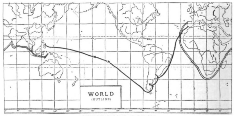
The Battle of Mactan (; ) was fought on a beach in Mactan Island (now part of Cebu, Philippines) between Spanish forces led by the Portuguese explorer Ferdinand Magellan along with local allies, and Lapulapu, the chieftain of the island, on the early morning hours of April 27, 1521. Magellan, a Portuguese Empire, Portuguese-born commander serving the Spanish Empire who led an Magellan expedition, expedition that ultimately circumnavigated the world for the first time, commanded a small Spanish contingent in an effort to subdue Mactan under the Spanish crown. The sheer number of Lapulapu's forces, compounded with issues associated with the location and the armor, ultimately resulted in a disastrous defeat for the Europeans and the death of Magellan. Surviving members of Magellan's crew continued the expedition under the command of Juan Sebastian de Elcano, who completed the journey in September 1522. The battle's exact details are lost to history, with Antonio Pigafetta's accoun ... [...More Info...] [...Related Items...] OR: [Wikipedia] [Google] [Baidu] |
Ferdinand Magellan
Ferdinand Magellan ( – 27 April 1521) was a Portuguese explorer best known for having planned and led the 1519–22 Spanish expedition to the East Indies. During this expedition, he also discovered the Strait of Magellan, allowing his fleet to pass from the Atlantic into the Pacific Ocean and perform the first European navigation to Asia via the Pacific. Magellan was killed in battle in the Philippines and his crew, commanded by the Spanish Juan Sebastián Elcano, completed the return trip to Spain in 1522 achieving the first circumnavigation of Earth in history. Born around 1480 into a family of minor Portuguese nobility, Magellan became a skilled sailor and naval officer in service of the Portuguese Crown in Asia. King Manuel I refused to support Magellan's plan to reach the Moluccas, or Spice Islands, by sailing westwards around the American continent. Magellan then proposed the same plan to King Charles I of Spain, who approved it. In Seville, he married, fathere ... [...More Info...] [...Related Items...] OR: [Wikipedia] [Google] [Baidu] |
Portugal
Portugal, officially the Portuguese Republic, is a country on the Iberian Peninsula in Southwestern Europe. Featuring Cabo da Roca, the westernmost point in continental Europe, Portugal borders Spain to its north and east, with which it shares Portugal-Spain border, the longest uninterrupted border in the European Union; to the south and the west is the North Atlantic Ocean; and to the west and southwest lie the Macaronesia, Macaronesian archipelagos of the Azores and Madeira, which are the two Autonomous Regions of Portugal, autonomous regions of Portugal. Lisbon is the Capital city, capital and List of largest cities in Portugal, largest city, followed by Porto, which is the only other Metropolitan areas in Portugal, metropolitan area. The western Iberian Peninsula has been continuously inhabited since Prehistoric Iberia, prehistoric times, with the earliest signs of Human settlement, settlement dating to 5500 BC. Celts, Celtic and List of the Pre-Roman peoples of the Iberia ... [...More Info...] [...Related Items...] OR: [Wikipedia] [Google] [Baidu] |
Cebu City
Cebu City, officially the City of Cebu, is a Cities of the Philippines#Legal classification, highly urbanized city in the Central Visayas region of the Philippines. According to the 2020 census, it has a population of 964,169 people, making it the sixth-most populated city in the nation and the most populous in the Visayas and the Central Visayas Region. It serves as the capital of Cebu wherein it is geographically situated and grouped under the province by the Philippine Statistics Authority, but is one of three cities (together with Lapu-Lapu City, Lapu-Lapu and Mandaue) that are administratively independent of the provincial government and also the largest city within that province. It also serves as the regional center of Central Visayas, and its Metro Cebu, metropolitan area exerts influence on commerce, trade, industry, education, culture, tourism, and healthcare beyond the region, over Central and Eastern Visayas and partly over Mindanao. It is the Philippines' main do ... [...More Info...] [...Related Items...] OR: [Wikipedia] [Google] [Baidu] |
Wikisource
Wikisource is an online wiki-based digital library of free-content source text, textual sources operated by the Wikimedia Foundation. Wikisource is the name of the project as a whole; it is also the name for each instance of that project, one for each language. The project's aim is to host all forms of free text, in many languages, and translations. Originally conceived as an archive to store useful or important historical texts, it has expanded to become a general-content library. The project officially began on November 24, 2003, under the name Project Sourceberg, a play on Project Gutenberg. The name Wikisource was adopted later that year and it received its own domain name. The project holds works that are either in the public domain or freely licensed: professionally published works or historical source documents, not vanity press, vanity products. Verification was initially made offline, or by trusting the reliability of other digital libraries. Now works are supported by ... [...More Info...] [...Related Items...] OR: [Wikipedia] [Google] [Baidu] |


