|
Luwian Studies
Luwian Studies is an independent, private, non-profit foundation based in Zürich, Switzerland. Its sole purpose is to promote the study of cultures of the second millennium BC in western Asia Minor. The foundation encourages and supports archaeological, linguistic and natural scientific investigations to complete the understanding of Middle and Late Bronze Age Mediterranean cultures. Western Anatolia was, at that point in time, home to groups of people who spoke Luwian, an Indo-European language. Board The Foundation is governed by its Board, which currently includes Matthias Örtle, Ivo Hajnal, Jorrit KelderJeffrey Spierand Eberhard Zangger. It is registered with the Handelsregisterambt of the Canton Zürich, under entry number CHE-364.060.070. Research Topic The term ''Luwian'' denotes a language and a hieroglyphic script which were commonly used in much of Asia Minor throughout the entire 2nd millennium BC. In the context of Luwian Studies, ''Luwian'', however, is a top ... [...More Info...] [...Related Items...] OR: [Wikipedia] [Google] [Baidu] |
Eberhard Zangger
Eberhard Zangger (born 1958 in Kamen, West Germany) is a Swiss geoarchaeologist, corporate communications consultant and publicist. Since 1994 he has been advocating the view that a Luwian civilization existed in Western Asia Minor during the 2nd millennium BC. In 2014 he established the international non-profit foundation Luwian Studies, whose president he is. Life and work Eberhard Zangger studied geology and paleontology at the University of Kiel and obtained a PhD from Stanford University in 1988. After this he was a senior research associate in the Department of Earth Sciences at the University of Cambridge (1988–91). In June 1991 he founded the consultancy office Geoarcheology International in Zurich, Switzerland, from where he participated archaeological projects in the eastern Mediterranean each year until 1999. Zangger began concentrating on geoarchaeology in 1982. His early research work and discoveries included the coastal situation of Dimini in Neolithic Cent ... [...More Info...] [...Related Items...] OR: [Wikipedia] [Google] [Baidu] |
Hittites
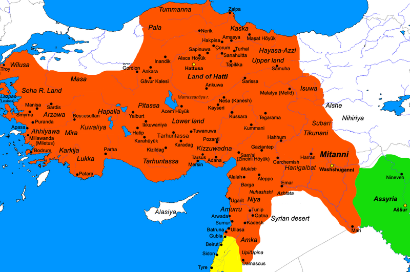
The Hittites () were an Anatolian people who played an important role in establishing first a kingdom in Kussara (before 1750 BC), then the Kanesh or Nesha kingdom (c. 1750–1650 BC), and next an empire centered on Hattusa in north-central Anatolia (around 1650 BC). This empire reached its height during the mid-14th century BC under Šuppiluliuma I, when it encompassed an area that included most of Anatolia as well as parts of the northern Levant and Upper Mesopotamia. Between the 15th and 13th centuries BC, the Empire of Hattusa—in modern times conventionally called the Hittite Empire—came into conflict with the New Kingdom of Egypt, the Middle Assyrian Empire and the empire of Mitanni for control of the Near East. The Middle Assyrian Empire eventually emerged as the dominant power and annexed much of the Hittite Empire, while the remainder was sacked by Phrygian newcomers to the region. After BC, during the Late Bronze Age collapse, the Hittites splintered in ... [...More Info...] [...Related Items...] OR: [Wikipedia] [Google] [Baidu] |
Frederik Christiaan Woudhuizen
Frederik Christiaan Woudhuizen (Zutphen, 13 February 1959 – Heiloo, 28 September 2021) was an independent scholar who studied ancient Indo-European languages, hieroglyphic Luvian/Luwian, and Mediterranean protohistory. He was the former editor of ''Talanta, Proceedings of the Dutch Archaeological and Historical Society''. Life Fred Woudhuizen graduated from high school in 1977. He finished his history studies in 1985 with an exam in Ancient History and specializing in Prehistory and Early History of the Mediterranean region. His education included Provincial Roman Archeology and the study of Classical languages, including Latin and Greek, as well as Luwian languages, Italian dialects and Mycenaeology. In 2006 he obtained his doctorate from Erasmus University Rotterdam with a Dissertation on ''The Ethnicity of the Sea Peoples''. From 1986 to 1989 and 1992 to 1995 Woudhuizen was editor of the Dutch journal ''Talanta, Proceedings of the Dutch Archaeological and Historical Socie ... [...More Info...] [...Related Items...] OR: [Wikipedia] [Google] [Baidu] |
Helmuth Theodor Bossert
Helmuth Theodor Bossert (September 11, 1889 – February 5, 1961) was a German art historian, philologist and archaeologist. He is best-known for his excavations of the Hittite fortress city at Karatepe, Turkey, and the discovery of bilingual inscriptions, which enabled the translation of Hittite hieroglyphs. Early life Bossert was born in Landau, German Empire, on September 11, 1889. He was educated in history of art, history, archaeology and German studies at the universities of Heidelberg, Strasbourg, Munich and Freiburg im Breisgau. In 1913, he was awarded the title PhD by University of Freiburg with a thesis on "Der ehemalige Hochaltar in Unserer Lieben Frauen Pfarrkirche zu Sterzing in Tirol" ("The former high altar in the Parish of "Our Lady of Marsh" to Sterzing in Tyrol). He began to work as an assistant at the Freiburg Library. Subsequently, he completed his military service in the German Army during World War I. After the World War, Bossert found a job at Ernst Wasmu ... [...More Info...] [...Related Items...] OR: [Wikipedia] [Google] [Baidu] |
Emil Forrer
Emil Orgetorix Gustav Forrer (also Emilio O. Forrer; ; 19 February 1894, Straßburg, Alsace-Lorraine – 10 January 1986, San Salvador) was a Swiss Assyriologist and pioneering Hittitologist. Moreover, Emil Forrer developed a deviant interdisciplinary field of research (''Meropisforschung''), based on textual fragments of the Greek historian Theopompus of Chios, and dealing with assumed pre- or protohistoric contacts between the Old- and the New World.Emil Forrer, Homerisch und silenisch Amerika', San Salvador (author's edition) 1975 Antithetic to the prevailing academic school of thought, Forrer advocated the idea that Theopomp's "Meropis" was not a fictional place but an actual geographic entity. Works * Forrer, E. ''Neue Probleme zum Ursprung der indogermanichen Sprachen''. “Mannus”, B. 26, 1934 * Forrer, E. Homerisch und silenisch Amerika', San Salvador (author's edition) 1975 See also * Meropis * Historicity of the Iliad * Wilusa Wilusa ( hit, ) or Wilusiya was a ... [...More Info...] [...Related Items...] OR: [Wikipedia] [Google] [Baidu] |
Assyriologist
Assyriology (from Greek , ''Assyriā''; and , ''-logia'') is the archaeological, anthropological, and linguistic study of Assyria and the rest of ancient Mesopotamia (a region that encompassed what is now modern Iraq, northeastern Syria, southeastern Turkey, and northwestern and southwestern Iran) and of the related cultures that used cuneiform writing. The field covers Sumer, the early Sumero-Akkadian city-states, the Akkadian Empire, Ebla, the Akkadian and Imperial Aramaic speaking states of Assyria, Babylonia and the Sealand Dynasty, the migrant foreign dynasties of southern Mesopotamia, including the Gutians, Amorites, Kassites, Arameans, Suteans and Chaldeans. The large number of cuneiform clay tablets preserved by these Sumero-Akkadian and Assyro-Babylonian cultures provide an extremely large resource for the study of the period. The region's (and indeed the world's) first cities and city-states like Ur are archaeologically invaluable for studying the growth of urb ... [...More Info...] [...Related Items...] OR: [Wikipedia] [Google] [Baidu] |
Hattusa
Hattusa (also Ḫattuša or Hattusas ; Hittite: URU''Ḫa-at-tu-ša'', Turkish: Hattuşaş , Hattic: Hattush) was the capital of the Hittite Empire in the late Bronze Age. Its ruins lie near modern Boğazkale, Turkey, within the great loop of the Kızılırmak River (Hittite: ''Marashantiya''; Greek: '' Halys''). Hattusa was added to the UNESCO World Heritage Site list in 1986. Surroundings The landscape surrounding the city included rich agricultural fields and hill lands for pasture as well as woods. Smaller woods are still found outside the city, but in ancient times, they were far more widespread. This meant the inhabitants had an excellent supply of timber when building their houses and other structures. The fields provided the people with a subsistence crop of wheat, barley and lentils. Flax was also harvested, but their primary source for clothing was sheep wool. They also hunted deer in the forest, but this was probably only a luxury reserved for the nobility. Do ... [...More Info...] [...Related Items...] OR: [Wikipedia] [Google] [Baidu] |
Lukka
The term Lukka lands (sometimes Luqqa lands), in Hittite language texts from the 2nd millennium BC, is a collective term for states formed by the Lukka people in south-west Anatolia (modern-day Turkey). The Lukka were never subjugated long-term by the Hittites, who generally viewed them as hostile. It is commonly accepted that the Bronze Age toponym Lukka is cognate with the Lycia of classical antiquity (8th century BC to 5th century AD). Location There are two somewhat different hypotheses with regard to the extent of the Lukka lands. The maximalist hypothesis is upheld by Trevor Bryce, who discusses the occurrences of Lukka in Bronze Age texts. "From these texts we can conclude the Lukka, or Lukka lands, referred to regions extending from the western end of Pamphylia, through Lycaonia, Pisidia and Lycia". The minimalist hypothesis is upheld by Ilya Yakubovich, who concludes based on the analysis of textual evidence: " have positive philological arguments for the presence of Br ... [...More Info...] [...Related Items...] OR: [Wikipedia] [Google] [Baidu] |
Wilusa
Wilusa ( hit, ) or Wilusiya was a Late Bronze Age city in western Anatolia known from references in fragmentary Hittite records. The city is notable for its identification with the archaeological site of Troy, and thus its potential connection to the legendary Trojan War. Identification with Troy Wilusa has been identified with the archaeological site of Troy. This correspondence was first proposed in 1924 by Emil Forrer, who also suggested that the name Ahhiyawa corresponds to the Homeric term for the Greeks, '' Achaeans''. Forrer's work was primarily motivated by linguistic similarities, since "Wilusa" and the associated placename "Taruisa" show striking parallels to the Greek names "Wilios" and "Troia" respectively. Subsequent research on Hittite geography has lent these identifications additional support and they are now generally accepted by scholars, though they are not regarded as firmly established. One alternative hypothesis proposes that Wilusa was located near B ... [...More Info...] [...Related Items...] OR: [Wikipedia] [Google] [Baidu] |
Hapalla
Hapalla ( Hittite: 𒄩𒁄𒆷 ''Hapalla'' or ''Haballa''), also written as Haballa, was a kingdom in central-western Anatolia around the middle of the 14th century BCE. Inhabited by speakers of the Luwian language, Hapalla was one of the Arzawa states, of which it was the easternmost. The kingdom of Hapalla existed until at least the end of the 13th century BCE. It remained a vassal to the Hittites for much of this time. The area was conquered by the Sea Peoples in 1180 BCE. History The first mention of Hapalla is when Arnuwanda I asks for help against a local uprising there. He bestows this duty to his vassal Madduwata, who betrays him by taking Hapalla for himself. After threats from Arnuwanda, Madduwata yields and hands it back to the Hittites. Later, when the Hittites are retaking their lands under Suppiluliuma I, he sends his army into Hapalla, whose capital is burnt down and inhabitants deported. In 1340 BC, an independent Seha River Land, Mira, and Hapalla are carved ... [...More Info...] [...Related Items...] OR: [Wikipedia] [Google] [Baidu] |
Masa (land)
Arzawa was a region and a political entity (a "kingdom" or a federation of local powers) in Western Anatolia in the second half of the 2nd millennium BC (roughly from the late 15th century BC until the beginning of the 12th century BC). The core of Arzawa is believed to be along the Kaystros River (now known as Küçük Menderes River), with its capital at Apasa, later known as Ephesus. When the Hittites conquered Arzawa, it was divided into three Hittite provinces: a southern province called Mira along the Maeander River, which would later become known as Caria; a northern province called the Seha River Land, along the Gediz River, which would later become known as Lydia; and an eastern province called Hapalla.J. David Hawkins (1998). ‘Tarkasnawa King of Mira: Tarkendemos, Boğazköy Sealings, and Karabel.’ ''Anatolian Studies'' 48:1–31. It succeeded the Assuwa league, which also included parts of western Anatolia, but was conquered by the Hittites c. 1400 BC. Arzawa w ... [...More Info...] [...Related Items...] OR: [Wikipedia] [Google] [Baidu] |


