|
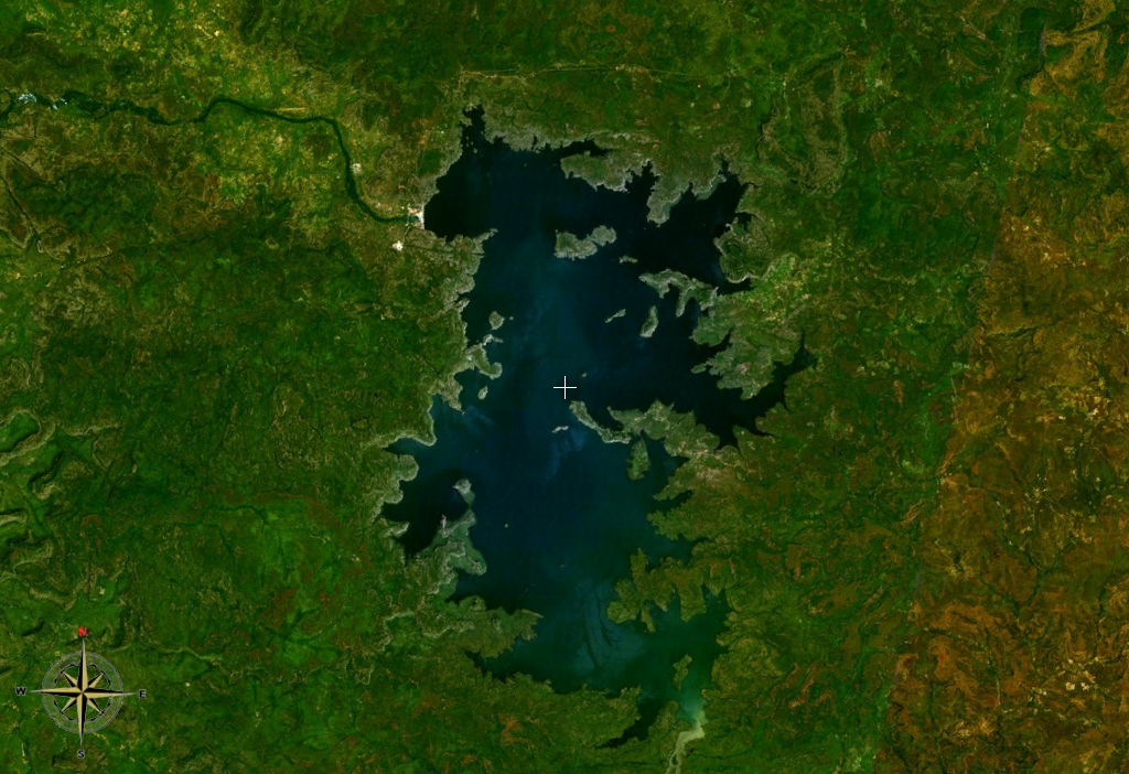
Lake Manantali
Lake Manantali is a large artificial lake, formed by the 1989 construction of the Manantali Dam, on the Bafing River in Mali Mali (; ), officially the Republic of Mali,, , ff, 𞤈𞤫𞤲𞥆𞤣𞤢𞥄𞤲𞤣𞤭 𞤃𞤢𞥄𞤤𞤭, Renndaandi Maali, italics=no, ar, جمهورية مالي, Jumhūriyyāt Mālī is a landlocked country in West Africa. Mal .... Its northern point is located 90 km to the south-east of the city of Bafoulabé. Size Lake Manantali covers 477 km2 and contains 11.3 billion m3 of water. Its formation forced 12,000 people from their homes and flooded 120 km2 of forest. The lake largely ended the flood patterns on both the Bafing and Senegal Rivers, compromising traditional agriculture which depended upon seasonal flooding. The lake has created benefits as well: consistent navigation downstream of the dam, irrigation of surrounding land, and a source for commercial fishing. The dam itself provides hydroelectric power t ... [...More Info...] [...Related Items...] OR: [Wikipedia] [Google] [Baidu] |
Manantali Dam
The Manantali Dam is a multi-purpose dam on the Bafing river in the Senegal River basin, to the south-east of Bafoulabé, in Mali's Kayes Region. History Early planning for the dam began in 1972 when the Organization for the Development of the Senegal River ( Organisation pour la mise en valeur du fleuve Sénégal, or OMVS) was set up by Mali, Mauritania and Senegal to develop the agricultural and hydropower potential of the basin. The World Bank declined to fund the dam in 1979, considering it an unreasonable investment. However, financing was secured mainly from Europe and construction on the dam began in 1982. It was completed in 1988, but without the hydropower plant. In 1989 the Mauritania–Senegal Border War stopped all work on the project. A Swiss journalist who visited Manantali in 1988 described the project as a "luxury car without a motor". In 1993 Carl–Dieter Spranger, then Germany's minister for development assistance, called Manantali an "act of economic and envi ... [...More Info...] [...Related Items...] OR: [Wikipedia] [Google] [Baidu] |
Bafing River
The Bafing River (Manding for "black river") is the upper course and largest tributary of the Senegal River which runs through Guinea and Mali and is about long. Course The Fonta Djallon in Guinea is the source of the Bafing River, north of Mamou. It flows for about and converges with the Bakoy River to join the Senegal River in western Africa.. The Bafing River is the largest tributary of the Senegal River, and contributes almost half of its total water volume. The Bafing forms part of the international border between Guinea and Mali. Irrigation Flooding from the Bafing River along the Senegal River had been traditionally relied on as a means of supporting local agriculture. However, a drought in the 1970s necessitated the construction of dams on both the Bafing River and the Senegal River. The Manantali hydroelectric dam, completed in 1987, is located on the Bafing River upstream of Bafoulabé. It forms the largest artificial lake in Mali, Lake Manantali. The dam retain ... [...More Info...] [...Related Items...] OR: [Wikipedia] [Google] [Baidu] |
Senegal
Senegal,; Wolof: ''Senegaal''; Pulaar: 𞤅𞤫𞤲𞤫𞤺𞤢𞥄𞤤𞤭 (Senegaali); Arabic: السنغال ''As-Sinighal'') officially the Republic of Senegal,; Wolof: ''Réewum Senegaal''; Pulaar : 𞤈𞤫𞤲𞤣𞤢𞥄𞤲𞤣𞤭 𞤅𞤫𞤲𞤫𞤺𞤢𞥄𞤤𞤭 (Renndaandi Senegaali); Arabic: جمهورية السنغال ''Jumhuriat As-Sinighal'') is a country in West Africa, on the Atlantic Ocean coastline. Senegal is bordered by Mauritania to the north, Mali to the east, Guinea to the southeast and Guinea-Bissau to the southwest. Senegal nearly surrounds the Gambia, a country occupying a narrow sliver of land along the banks of the Gambia River, which separates Senegal's southern region of Casamance from the rest of the country. Senegal also shares a maritime border with Cape Verde. Senegal's economic and political capital is Dakar. Senegal is notably the westernmost country in the mainland of the Old World, or Afro-Eurasia. It owes its name to t ... [...More Info...] [...Related Items...] OR: [Wikipedia] [Google] [Baidu] |
Lake
A lake is an area filled with water, localized in a basin, surrounded by land, and distinct from any river or other outlet that serves to feed or drain the lake. Lakes lie on land and are not part of the ocean, although, like the much larger oceans, they do form part of the Earth's water cycle. Lakes are distinct from lagoons, which are generally coastal parts of the ocean. Lakes are typically larger and deeper than ponds, which also lie on land, though there are no official or scientific definitions. Lakes can be contrasted with rivers or streams, which usually flow in a channel on land. Most lakes are fed and drained by rivers and streams. Natural lakes are generally found in mountainous areas, rift zones, and areas with ongoing glaciation. Other lakes are found in endorheic basins or along the courses of mature rivers, where a river channel has widened into a basin. Some parts of the world have many lakes formed by the chaotic drainage patterns left over from the la ... [...More Info...] [...Related Items...] OR: [Wikipedia] [Google] [Baidu] |
Mali
Mali (; ), officially the Republic of Mali,, , ff, 𞤈𞤫𞤲𞥆𞤣𞤢𞥄𞤲𞤣𞤭 𞤃𞤢𞥄𞤤𞤭, Renndaandi Maali, italics=no, ar, جمهورية مالي, Jumhūriyyāt Mālī is a landlocked country in West Africa. Mali is the eighth-largest country in Africa, with an area of over . The population of Mali is million. 67% of its population was estimated to be under the age of 25 in 2017. Its capital and largest city is Bamako. The sovereign state of Mali consists of eight regions and its borders on the north reach deep into the middle of the Sahara Desert. The country's southern part is in the Sudanian savanna, where the majority of inhabitants live, and both the Niger and Senegal rivers pass through. The country's economy centres on agriculture and mining. One of Mali's most prominent natural resources is gold, and the country is the third largest producer of gold on the African continent. It also exports salt. Present-day Mali was once part ... [...More Info...] [...Related Items...] OR: [Wikipedia] [Google] [Baidu] |
Bafoulabé
Bafoulabé is a town and rural commune in south-western Mali. It is located in the Region of Kayes at the confluence of the Bafing and Bakoy rivers which join to become the Sénégal River. Bafoulabé is the capital of the Cercle of Bafoulabé, which in 1887 was the first Cercle to be created in Mali. Local administration Until the 1996 law creating communes, Bafoulabé Commune was an arrondissement. While now deprecated, the commune retains the same boundaries, extending far beyond the town of Bafoulabé, its seat (''chef-lieu''). Bafoulabé is also the seat of the larger Bafoulabé Cercle. Apart from the town, there are 28 villages, official rural subdivisions within the Commune. It is a ''Rural Commune'', meaning it is subdivided in villages, in contrast to the smaller ''Urban Commune'', divided into urban Quarters. Commune affairs are directed by an elected Commune Council (''conseil communal'') of 23 members and a Commune executive (''bureau communal'') of the elected ... [...More Info...] [...Related Items...] OR: [Wikipedia] [Google] [Baidu] |
Senegal River
,french: Fleuve Sénégal) , name_etymology = , image = Senegal River Saint Louis.jpg , image_size = , image_caption = Fishermen on the bank of the Senegal River estuary at the outskirts of Saint-Louis, Senegal , map = Senegalrivermap.png , map_size = , map_caption = Map of the Senegal River drainage basin. , pushpin_map = , pushpin_map_size = , pushpin_map_caption= , subdivision_type1 = Country , subdivision_name1 = Senegal, Mauritania, Mali , subdivision_type2 = , subdivision_name2 = , subdivision_type3 = , subdivision_name3 = , subdivision_type4 = , subdivision_name4 = , subdivision_type5 = , subdivision_name5 = , length = , width_min = , width_avg = , width_max = , depth_min = , depth_avg = , depth_max = , discharge1_location= , discharge1_min = , discharge1_avg = , ... [...More Info...] [...Related Items...] OR: [Wikipedia] [Google] [Baidu] |
Erklärung Von Bern
Public Eye is a sustainability-oriented, politically and religiously independent solidarity development non-governmental organisation based in Switzerland. Public Eye notably encourages Swiss politics and business to respect human rights and the Natural environment, environment in poor countries. History and orientation Erklärung von Bern, literally ''Berne Declaration'', was founded in 1968 by the merger of signatories to a manifesto on “Switzerland and the Developing Countries“ by a group of theologians, which objected to the growing differences in prosperity between the so-called first world and the third world. One thousand people signed the consequently called ''Erklärung von Bern'', meaning declaration of Bern, and among other things declared to contribute 3% of their income towards development cooperation. On 6 January 1969 the manifesto was presented to the Swiss Federal Council. In 1971, the movement was constituted into an association. EvB was since the 1970s ... [...More Info...] [...Related Items...] OR: [Wikipedia] [Google] [Baidu] |


