|
King Christian IX Land
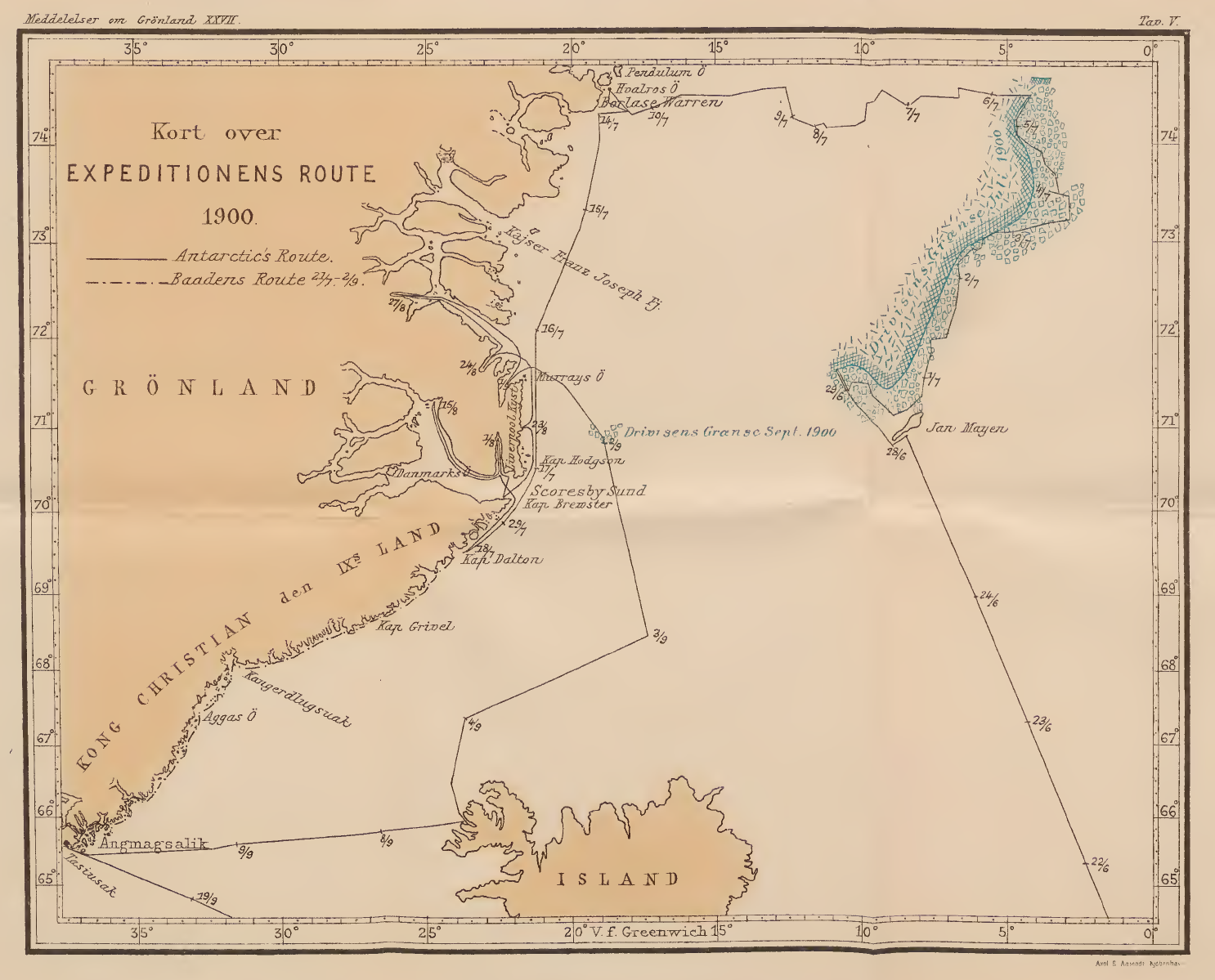
King Christian IX Land ( da, Kong Christian IX Land) is a coastal area of Southeastern Greenland in Sermersooq Municipality fronting the Denmark Strait and extending through the Arctic Circle from 65°N to 70°N. History This area was named in September 1884 by Gustav Frederik Holm who claimed it for Denmark, naming it after the then-reigning Danish King Christian IX. Geography King Christian IX Land is bordered by King Frederick VI Coast on the south, King Christian X Land and the Scoresby Sound to the north, and the Greenland Ice Sheet to the west. Greenland's highest mountain range, the Watkins Range, as well as the nearly as high Schweizerland are located in this region. The shore area of King Christian IX Land includes the Blosseville Coast to the east. There are many fjords, the largest of which are Sermilik, Kangerlussuaq and Kangertittivatsiaq, as well as numerous coastal islands, including Ammassalik which is the site of the most populous town in Eastern Green ... [...More Info...] [...Related Items...] OR: [Wikipedia] [Google] [Baidu] |
Region
In geography, regions, otherwise referred to as zones, lands or territories, are areas that are broadly divided by physical characteristics ( physical geography), human impact characteristics ( human geography), and the interaction of humanity and the environment (environmental geography). Geographic regions and sub-regions are mostly described by their imprecisely defined, and sometimes transitory boundaries, except in human geography, where jurisdiction areas such as national borders are defined in law. Apart from the global continental regions, there are also hydrospheric and atmospheric regions that cover the oceans, and discrete climates above the land and water masses of the planet. The land and water global regions are divided into subregions geographically bounded by large geological features that influence large-scale ecologies, such as plains and features. As a way of describing spatial areas, the concept of regions is important and widely used among the many branch ... [...More Info...] [...Related Items...] OR: [Wikipedia] [Google] [Baidu] |
Schweizerland
Schweizerland, also known as Schweizerland Alps, is a mountain range in King Christian IX Land, eastern Greenland. Administratively this range is part of the Sermersooq Municipality.Google Earth Its highest point is one of the highest peaks in Greenland. Owing to its high peaks Schweizerland is a popular climbing destination, together with the Watkins Range to the northeast and the Stauning Alps further north. Tasiilaq Heliport is located near the area of the range. History The range was formerly a remote unknown area. It was named 'Schweizerland' in 1912 by Swiss geophysicist and Arctic explorer Alfred de Quervain following the Second Swiss Expedition in which he crossed the Greenland ice cap from Godhavn (Qeqertarsuaq) on the west, to Sermilik Fjord on the eastern side. De Quervain also identified the position and approximate height of Mont Forel, highest point of Schweizerland. Mont Forel was then thought to be the highest mountain in the Arctic Circle area. However, at ... [...More Info...] [...Related Items...] OR: [Wikipedia] [Google] [Baidu] |
Operational Navigation Chart C-13, 3rd Edition
An operational definition specifies concrete, replicable procedures designed to represent a construct. In the words of American psychologist S.S. Stevens (1935), "An operation is the performance which we execute in order to make known a concept." For example, an operational definition of "fear" (the construct) often includes measurable physiologic responses that occur in response to a perceived threat. Thus, "fear" might be operationally defined as specified changes in heart rate, galvanic skin response, pupil dilation, and blood pressure. Overview An operational definition is designed to model or represent a concept or theoretical definition, also known as a construct. Scientists should describe the operations (procedures, actions, or processes) that define the concept with enough specificity such that other investigators can replicate their research. Operational definitions are also used to define system states in terms of a specific, publicly accessible process of preparation ... [...More Info...] [...Related Items...] OR: [Wikipedia] [Google] [Baidu] |
Sermiligaaq
Sermiligaaq (old spelling: ''Sermiligâk´'') is a settlement in the Sermersooq municipality in southeastern Greenland. It is located near the Sermilik Fjord. Its population was 209 in 2020. In Kalaallisut, its name means "Beautiful Glacierfjord". Geography The small island of Quujuutilik (also spelled Kujutilik or Qûjûtilik) is located off the coast northeast of Sermiligaaq. Transport The settlement is served by the Sermiligaaq Heliport. Population The population of Sermiligaaq has slowly increased in the last two decades, unlike in the neighboring settlements of Kuummiit and Kulusuk Kulusuk (old spelling: ''Qulusuk''Eastgreenland.com.Kulusuk".), formerly Kap Dan, is a settlement in the Sermersooq municipality in southeastern Greenland, located on an island of the same name. The settlement population of 241 includes many Dane ....Statistics Greenlan ... [...More Info...] [...Related Items...] OR: [Wikipedia] [Google] [Baidu] |
Tasiilaq
Tasiilaq, formerly Ammassalik and Angmagssalik, is a town in the Sermersooq municipality in southeastern Greenland. With 1,985 inhabitants as of 2020, it is the most populous community on the eastern coast, and the seventh-largest town in Greenland. The Sermilik Station, dedicated to the research of the nearby Mittivakkat Glacier, is located near the town. History Prehistory to the fifteenth century The people of Saqqaq culture were the first to reach eastern Greenland, arriving from the north,eastgreenland.com ''History of East Greenland'' through what is now known as Peary Land and Independence Fjord, to be surpassed by the [...More Info...] [...Related Items...] OR: [Wikipedia] [Google] [Baidu] |
Ammassalik Island
Ammassalik Island ( da, Ammassalik Ø) is an island in the Sermersooq municipality in southeastern Greenland, with an area of .Norwegian University of Science and Technology Geography Ammassalik Island is located in the region. Separating Ammassalik Island from the mainland of Greenland are the wide Sermilik Fjord in the west and the Ikaasartivaq Strait in the northeast. To the east and southeast, the progres ...[...More Info...] [...Related Items...] OR: [Wikipedia] [Google] [Baidu] |
Kangertittivatsiaq
Kangertittivatsiaq, old spelling ''Kangerdlugssuatsiak'', meaning "The rather large fjord," is a fjord in Sermersooq, Eastern Greenland. There are numerous ruins of former relatively large Inuit settlements near the mouth of the fjord. These were first reported by Georg Carl Amdrup at the turn of the 20th century when no Inuit were living in the area anymore. Geography Kangertittivatsiaq is located in King Christian IX Land, north of Tasiilaq (Amassalik). It is a long fjord running roughly from northwest to southeast for about 26 km. Nordfjord branches northwards at the southern end of the fjord and Sammilik Fjord branches roughly southwestwards on the western side of its mouth. Storo Island and smaller Eskimo Island are located off the fjord's mouth to the south. Mountains There are high mountains on both sides of Kangertittivatsiaq. Well-known Ingolf Fjeld rises to a height of on the northeastern side of the inner fjord at . Bibliography *Spencer Apollonio, ''Lands That H ... [...More Info...] [...Related Items...] OR: [Wikipedia] [Google] [Baidu] |
Kangerlussuaq Fjord, East Greenland
Kangerlussuaq Fjord ( kl, Kangerlussuaq, meaning 'large fjord'; da, Stor Fjord) is a fjord in eastern Greenland. It is part of the Sermersooq municipality. The fjord was named by the East-Greenland Coast Expedition led by Georg Carl Amdrup in 1900. Currently drilling explorations are being carried out for the possible exploitation of gold, palladium and platinum in the Kangerlussuaq area.Project Update and Activities' (PDF; 1,9 MB), Platina Resources Ltd., 26. Februar 2014 (englisch) History The eastern coast of Greenland was inhabited by Paleo-Eskimo people 4000 years ago and the Kangerlussuaq Fjord was likely visited by hunters. A quartz hand scraper found in Cape Irminger —24 km east of Cape Hammer— proves that the region was visited at least 2000 years ago.Christian Glahder: ''Hunting in Kangerlussuaq, East Greenland, 1951–1991. An Assessment of Local Knowledge'' (= ''Meddelelser om Grønland, Man & Society'', Nr. 19, 1995)p. 12/ref> Inuit lived in the ar ... [...More Info...] [...Related Items...] OR: [Wikipedia] [Google] [Baidu] |
Sermilik
Sermilik ( da, Egede og Rothes Fjord) is a fjord in eastern Greenland. It is part of the Sermersooq municipality. The settlement of Tasiilaq is located about 15 km to the east of the mouth of the fjord. Geography This fjord, whose Greenlandic name 'Sermilik' means 'place with glaciers' is located at the southern end of King Christian IX Land, west of Ammassalik Fjord. It is one of the largest fjords in the southeastern coast of Greenland. Its waters are fed by the Helheim Glacier, Fenris Glacier and Midgard Glacier among others. The fjord stretches inland in a roughly northern direction and splits into two branches at its head —at the southern limit of Schweizerland, the western one being the Helheim Fjord and the right one the Ningerti. Sermilik's mouth is located between Kitak Island and Cape Tycho Brahe in the Denmark Strait area of the Atlantic Ocean. Kangersivartikajik is the next fjord to the east along the coast. Near the fjord's entrance on the western ... [...More Info...] [...Related Items...] OR: [Wikipedia] [Google] [Baidu] |
Fjords
In physical geography, a fjord or fiord () is a long, narrow inlet with steep sides or cliffs, created by a glacier. Fjords exist on the coasts of Alaska, Antarctica, British Columbia, Chile, Denmark, Germany, Greenland, the Faroe Islands, Iceland, Ireland, Kamchatka, the Kerguelen Islands, Labrador, Newfoundland, New Zealand, Norway, Novaya Zemlya, Nunavut, Quebec, the Patagonia region of Argentina and Chile, Russia, South Georgia Island, Tasmania, United Kingdom, and Washington state. Norway's coastline is estimated to be long with its nearly 1,200 fjords, but only long excluding the fjords. Formation A true fjord is formed when a glacier cuts a U-shaped valley by ice segregation and abrasion of the surrounding bedrock. According to the standard model, glaciers formed in pre-glacial valleys with a gently sloping valley floor. The work of the glacier then left an overdeepened U-shaped valley that ends abruptly at a valley or trough end. Such valleys are fjords when floo ... [...More Info...] [...Related Items...] OR: [Wikipedia] [Google] [Baidu] |
Blosseville Coast
The Blosseville Coast ( da, Blosseville Kyst) is a long stretch of coast in King Christian IX Land, eastern Greenland. Administratively it belongs to the Sermersooq Municipality. The Blosseville Coast is steep and difficult to access by ship owing to the great number of ice floes, frequent fog, dangerous currents and lack of good anchorages. History This stretch of coast is named after French Lieutenant Jules de Blosseville, commander of "La Lilloise". In 1833 Lt. Blosseville first sighted the stretch of unexplored coast between the 68th and the 69th parallel north. He decided to survey the coast more thoroughly and sailed first to Iceland to make repairs on his ship. Then he headed back to the area of this coast but was lost without a trace. In the years that followed, three expeditions were organized to find Lt. Blosseville and the 83 other men on the ship but no trace was found. The coast was finally explored and mapped in 1900 by Georg Carl Amdrup in the course of the Carlsb ... [...More Info...] [...Related Items...] OR: [Wikipedia] [Google] [Baidu] |
Watkins Range
The Watkins Range ( da, Watkins Bjerge) is Greenland's highest mountain range. It is located in King Christian IX Land, Sermersooq municipality. The range was named after British Arctic explorer Gino Watkins. History Made up entirely of nunataks, this remote range was formerly an unknown area. In 1912 Swiss geophysicist and Arctic explorer Alfred De Quervain crossed the Greenland ice cap from Godhavn (Qeqertarsuaq) on the west, to Sermilik Fjord on the eastern side and saw a range system that he named 'Schweizerland', marking the position and approximate height of Mont Forel, the highest point of that area Lacking accurate data, Mont Forel was then thought to be the highest mountain in the Arctic Circle area, together with Petermann Peak far to the north. However, in 1930 Gino Watkins, leader of the British Arctic Air Route Expedition, discovered a new mountain range from the air located over 350 km to the northeast of Schweizerland that he named 'New Mountains'. Thi ... [...More Info...] [...Related Items...] OR: [Wikipedia] [Google] [Baidu] |


.jpg)