|
Kibaran Orogeny
The Kibaran orogeny is a term that has been used for a series of orogenic events, in what is now Africa, that began in the Mesoproterozoic, around 1400 Ma and continued until around 1000 Ma when the supercontinent Rodinia was assembled. The term "Kibaran" has often been used for any orogenic rocks formed during this very extended period. Recently, it has been proposed that the term should be used in a much narrower sense for an event around 1375 Ma and a region in the southeast of the Democratic Republic of the Congo (DRC). These orogenic events are also known as the Grenville orogeny in North America and the Dalslandian orogeny in Western Europe. Broad sense Regions that contain relics of Kibaran age include the Kibara Mountains of the eastern DRC and Namaqua-Natal belt in southern Africa. Rocks of this age have been found in the Hoggar Mountains, in northwest and southwest Nigeria and in Cameroon to the north of the Congo Craton. The orogeny in northwest Nigeria was a majo ... [...More Info...] [...Related Items...] OR: [Wikipedia] [Google] [Baidu] |
Orogeny
Orogeny is a mountain building process. An orogeny is an event that takes place at a convergent plate margin when plate motion compresses the margin. An '' orogenic belt'' or ''orogen'' develops as the compressed plate crumples and is uplifted to form one or more mountain ranges. This involves a series of geological processes collectively called orogenesis. These include both structural deformation of existing continental crust and the creation of new continental crust through volcanism. Magma rising in the orogen carries less dense material upwards while leaving more dense material behind, resulting in compositional differentiation of Earth's lithosphere ( crust and uppermost mantle). A synorogenic process or event is one that occurs during an orogeny. The word "orogeny" () comes from Ancient Greek (, , + , , ). Although it was used before him, the term was employed by the American geologist G. K. Gilbert in 1890 to describe the process of mountain-building as distinguis ... [...More Info...] [...Related Items...] OR: [Wikipedia] [Google] [Baidu] |
Tanzania Craton
The Tanzania Craton is an old and stable part of the continental lithosphere in central Tanzania. Some of the rocks are over 3 billion years old. Setting The Tanzania Craton forms the highest part of the East African Plateau. The craton is surrounded by Proterozoic mobile belts of various ages and grades of metamorphism. These include the Ubendian, Usagaran, Karagwe-Ankolean and Bukoban systems. The Mozambique Belt lies to the east. The craton divides the east and west branches of the East African Rift. The southern end of the Gregory Rift Valley terminates against the craton. The volcanic area of this rift covers the surface interface between the Mozambique orogenic fold belt and the Tanzania Craton. A superplume exists beneath the craton. An indirect effect of rift and plume associated volcanism in the Tanzania Craton is the high levels of soil nutrients in Serengeti provided by volcanic ash from Ol Doinyo Lengai. Composition The craton is a composite of several different ... [...More Info...] [...Related Items...] OR: [Wikipedia] [Google] [Baidu] |
Precambrian Research
''Precambrian Research'' is a peer-reviewed scientific journal covering the geology of the Earth and its planetary neighbors. It is published by Elsevier and, , the editors-in-chief are V. Pease (Stockholm University) and G.C. Zhao ( University of Hong Kong). It was established in 1974. According to the '' Journal Citation Reports'', the journal has a 2013 impact factor The impact factor (IF) or journal impact factor (JIF) of an academic journal is a scientometric index calculated by Clarivate that reflects the yearly mean number of citations of articles published in the last two years in a given journal, as i ... of 6.023. References External links * * Geology journals Elsevier academic journals English-language journals Publications established in 1974 {{geology-journal-stub ... [...More Info...] [...Related Items...] OR: [Wikipedia] [Google] [Baidu] |
Lake Tanganyika
Lake Tanganyika () is an African Great Lake. It is the second-oldest freshwater lake in the world, the second-largest by volume, and the second-deepest, in all cases after Lake Baikal in Siberia. It is the world's longest freshwater lake. The lake is shared among four countries—Tanzania, the Democratic Republic of the Congo (DRC), Burundi, and Zambia, with Tanzania (46%) and DRC (40%) possessing the majority of the lake. It drains into the Congo River system and ultimately into the Atlantic Ocean. Etymology "Tanganika" was the name of the lake that Henry Morton Stanley encountered when he was at Ujiji in 1876. The name first originated from the Bembe language when they arrived in South Kivu around the 7th century, they discovered the lake and started calling it “êtanga ‘ya’ni’â” which means “a big river” in their Bantu language. Stanley found also other names for the lake among different ethnic groups, like the Kimana, the Yemba and the Msaga. An altern ... [...More Info...] [...Related Items...] OR: [Wikipedia] [Google] [Baidu] |
Eburnean Orogeny
The Eburnean orogeny, or Eburnean cycle, was a series of tectonic, metamorphic and plutonic events in what is now West Africa during the Paleoproterozoic era about 2200–2000 million years ago. During this period the Birimian domain in West Africa was established and structured. Eburnian faults are found in the Eglab shield to the north of the West African craton and in the Man Shield to the south of the craton. There is evidence of three major Eburnean magmatic events in the Eglab shield. Between 2210 and 2180 Ma, a metamorphosed batholith was formed in the Lower Reguibat Complex (LRC). Around 2090 Ma, a syntectonic trondhjemitic pluton intruded into the Archaean reelects of the Chegga series. Around 2070 Ma an asthenospheric upwelling released a large volume of post-orogenic magmas. Eburnian trends within the Eglab shield were repeatedly reactivated from the Neoproterozoic to the Mesozoic. See also *Geology of Ghana The geology of Ghana is primarily very ancient crystal ... [...More Info...] [...Related Items...] OR: [Wikipedia] [Google] [Baidu] |
Large Igneous Province
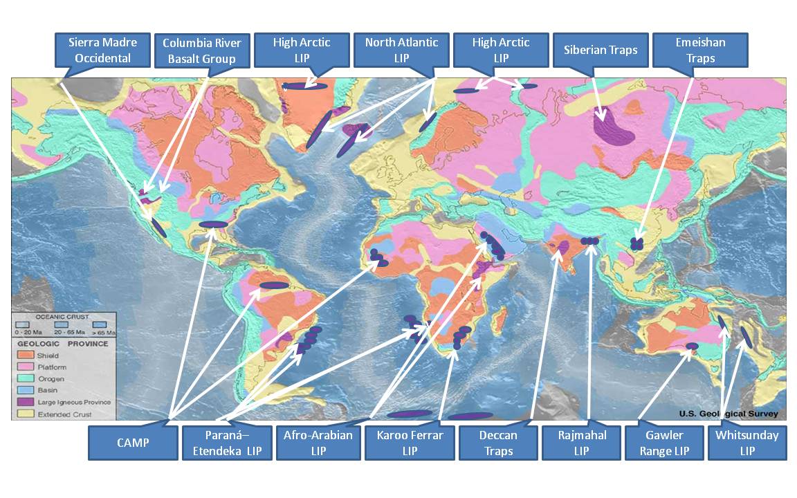
A large igneous province (LIP) is an extremely large accumulation of igneous rocks, including intrusive (sills, dikes) and extrusive (lava flows, tephra deposits), arising when magma travels through the crust towards the surface. The formation of LIPs is variously attributed to mantle plumes or to processes associated with divergent plate tectonics. The formation of some of the LIPs in the past 500 million years coincide in time with mass extinctions and rapid climatic changes, which has led to numerous hypotheses about causal relationships. LIPs are fundamentally different from any other currently active volcanoes or volcanic systems. Definition In 1992 researchers first used the term ''large igneous province'' to describe very large accumulations—areas greater than 100,000 square kilometers (approximately the area of Iceland)—of mafic igneous rocks that were erupted or emplaced at depth within an extremely short geological time interval: a few million years or less. Ma ... [...More Info...] [...Related Items...] OR: [Wikipedia] [Google] [Baidu] |
Maniema
Maniema is one of 26 provinces of the Democratic Republic of the Congo. Its capital is Kindu. Toponymy Henry Morton Stanley explored the area, calling it Manyema.Stanley, H.M., 1899, Through the Dark Continent, London: G. Newnes, Vol. One , Vol. Two Geography Maniema borders the provinces of Sankuru to the west, Tshopo to the north, North Kivu and South Kivu to the east, and Lomami and Tanganyika to the south. Maniema province has 7 territories, which are: # Kabambare # Kailo # Kasongo # Kibombo # Lubutu # Pangi # Punia Political divisions Maniema consists of the city of Kindu and seven territories: Punia, Pangi, Lubutu, Kibombo, Kasongo, Kailo and Kabambare. The city of Kindu has the communes of Alunguli, Kasuku and Mikelenge Economy Mining is the main industry in the province and diamonds, copper, gold and cobalt are mined outside of Kindu. Kailo Territory is home to open pit wolframite and Cassiterite mines. Education * University of Kindu See also * ... [...More Info...] [...Related Items...] OR: [Wikipedia] [Google] [Baidu] |
Kivu
Kivu was the name for a large "region" in the Democratic Republic of the Congo under the rule of Mobutu Sese Seko that bordered Lake Kivu. It included three "Sub-Regions" ("Sous-Régions" in French): Nord-Kivu, Sud-Kivu and Maniema, corresponding to the three current provinces created in 1986. The capital of the Kivu Region was in Bukavu, and the capitals of the three Sub-Regions were in Goma, Uvira and Kindu. Kivu has been repeatedly subjected to major conflicts since the early 20th century. Under Belgian colonial rule, it was the site of several religious revolts such as the 1944 Kivu uprising. Following independence, it was a battleground of the Simba rebellion, First Congo War, and Second Congo War, and has been the site of an ongoing military conflict since the early 2000s. In addition, an Ebola epidemic affected the region from August 2018 to June 2020. Geography Kivu is also the name for the entire region surrounding Lake Kivu, including the portions in Rwanda w ... [...More Info...] [...Related Items...] OR: [Wikipedia] [Google] [Baidu] |
Uganda
}), is a landlocked country in East Africa. The country is bordered to the east by Kenya, to the north by South Sudan, to the west by the Democratic Republic of the Congo, to the south-west by Rwanda, and to the south by Tanzania. The southern part of the country includes a substantial portion of Lake Victoria, shared with Kenya and Tanzania. Uganda is in the African Great Lakes region. Uganda also lies within the Nile basin and has a varied but generally a modified equatorial climate. It has a population of around 49 million, of which 8.5 million live in the capital and largest city of Kampala. Uganda is named after the Buganda kingdom, which encompasses a large portion of the south of the country, including the capital Kampala and whose language Luganda is widely spoken throughout the country. From 1894, the area was ruled as a protectorate by the United Kingdom, which established administrative law across the territory. Uganda gained independence from the UK o ... [...More Info...] [...Related Items...] OR: [Wikipedia] [Google] [Baidu] |
Katanga Province
Katanga was one of the four large provinces created in the Belgian Congo in 1914. It was one of the eleven provinces of the Democratic Republic of the Congo between 1966 and 2015, when it was split into the Tanganyika, Haut-Lomami, Lualaba, and Haut-Katanga provinces. Between 1971 and 1997 (during the rule of Mobutu Sese Seko when Congo was known as Zaire), its official name was Shaba Province. Katanga's area encompassed . Farming and ranching are carried out on the Katanga Plateau. The eastern part of the province is considered to be a rich mining region, which supplies cobalt, copper, tin, radium, uranium, and diamonds. The region's former capital, Lubumbashi, is the second-largest city in the Congo. History Copper mining in Katanga dates back over 1,000 years, and mines in the region were producing standard-sized ingots of copper for international transport by the end of the 10th century CE. In the 1890s, the province was beleaguered from the south by Cecil Rhodes' ... [...More Info...] [...Related Items...] OR: [Wikipedia] [Google] [Baidu] |


