|
Kavrayskiy VII
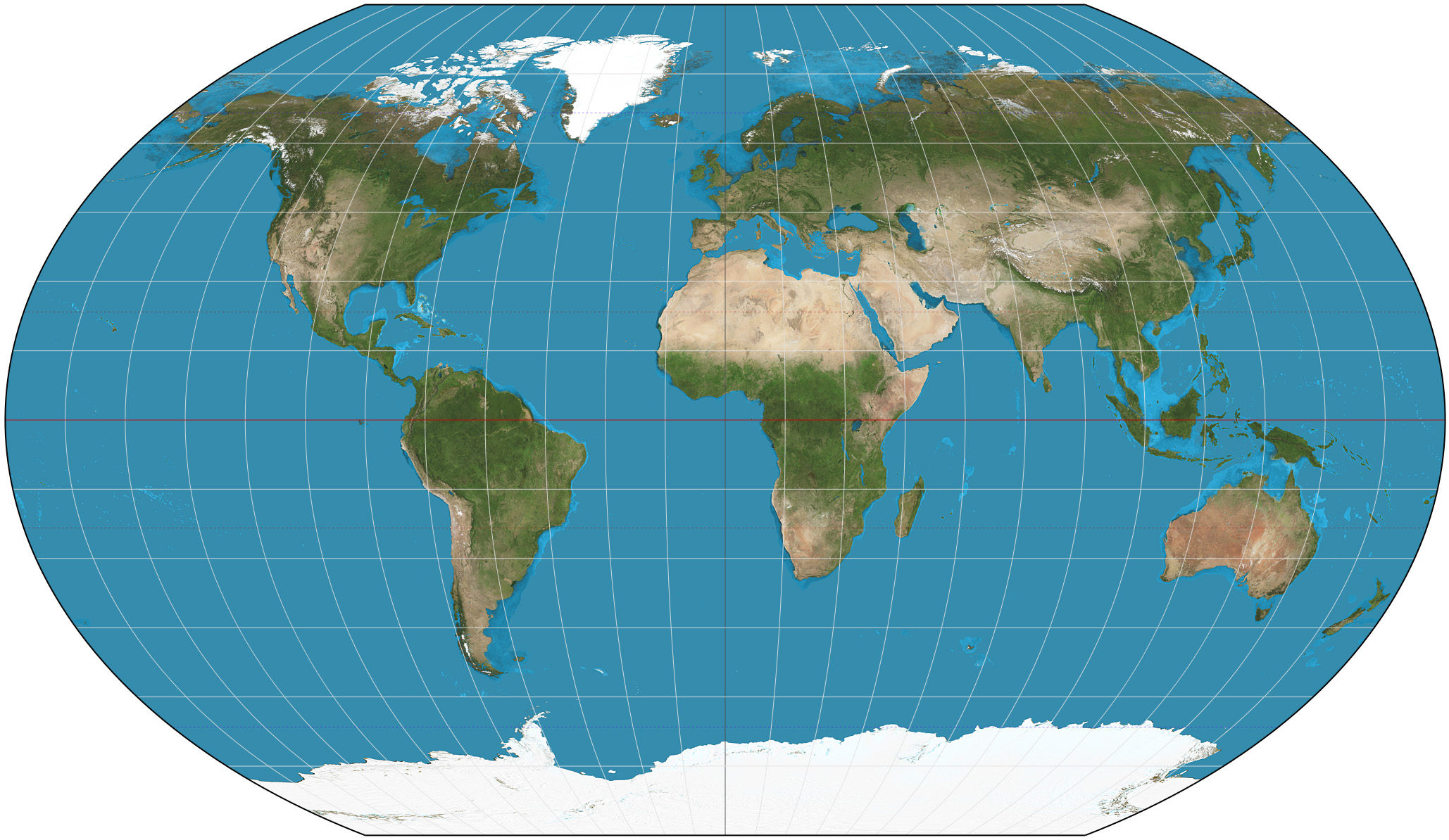
The Kavrayskiy VII projection is a map projection invented by Soviet cartographer Vladimir V. Kavrayskiy in 1939 for use as a general-purpose pseudocylindrical projection. Like the Robinson projection, it is a compromise intended to produce good-quality maps with low distortion overall. It scores well in that respect compared to other popular projections, such as the Winkel tripel projection, Winkel tripel, despite straight, evenly spaced Parallel (latitude), parallels and a simple formulation. Regardless, it has not been widely used outside the former Soviet Union. The projection is defined as \begin x &= \frac \sqrt \\ y &= \varphi \end where \lambda is the longitude, and \varphi is the latitude in radians. See also * List of map projections * Cartography * Wagner VI projection * Robinson projection References External links Curvature in Map Projections quantification of overall distortion in projections. Mapthematics Kavrayskiy VII bivariate distortion map. desc ... [...More Info...] [...Related Items...] OR: [Wikipedia] [Google] [Baidu] |
Map Projection
In cartography, a map projection is any of a broad set of Transformation (function) , transformations employed to represent the curved two-dimensional Surface (mathematics), surface of a globe on a Plane (mathematics), plane. In a map projection, coordinates, often expressed as latitude and longitude, of locations from the surface of the globe are transformed to coordinates on a plane. Projection is a necessary step in creating a two-dimensional map and is one of the essential elements of cartography. All projections of a sphere on a plane necessarily distort the surface in some way. Depending on the purpose of the map, some distortions are acceptable and others are not; therefore, different map projections exist in order to preserve some properties of the sphere-like body at the expense of other properties. The study of map projections is primarily about the characterization of their distortions. There is no limit to the number of possible map projections. More generally, proje ... [...More Info...] [...Related Items...] OR: [Wikipedia] [Google] [Baidu] |
Vladimir V
Vladimir (, , Reforms of Russian orthography, pre-1918 orthography: ) is a masculine given name of Slavs, Slavic origin, widespread throughout all Slavic nations in different forms and spellings. The earliest record of a person with the name is Vladimir of Bulgaria (). Etymology The Old East Slavic form of the name is Володимѣръ ''Volodiměr'', while the Old Church Slavonic form is ''Vladiměr''. According to Max Vasmer, the name is composed of Slavic владь ''vladĭ'' "to rule" and ''*mēri'' "great", "famous" (related to Gothic language, Gothic element ''mērs'', ''-mir'', cf. Theodemir, Theode''mir'', Valamir, Vala''mir''). The modern (Reforms of Russian orthography#The post-revolution reform, pre-1918) Russian forms Владимиръ and Владиміръ are based on the Church Slavonic one, with the replacement of мѣръ by миръ or міръ resulting from a folk etymology, folk etymological association with :wikt:Reconstruction:Proto-Slavic/mirъ, м ... [...More Info...] [...Related Items...] OR: [Wikipedia] [Google] [Baidu] |
Robinson Projection
The Robinson projection is a map projection of a world map that shows the entire world at once. It was specifically created in an attempt to find a good compromise to the problem of readily showing the whole globe as a flat image. The Robinson projection was devised by Arthur H. Robinson in 1963 in response to an appeal from the Rand McNally company, which has used the projection in general-purpose world maps since that time. Robinson published details of the projection's construction in 1974. The National Geographic Society (NGS) began using the Robinson projection for general-purpose world maps in 1988, replacing the Van der Grinten projection. In 1998, the NGS abandoned the Robinson projection for that use in favor of the Winkel tripel projection, as the latter "reduces the distortion of land masses as they near the poles". Strengths and weaknesses The Robinson projection is neither equal-area nor conformal, abandoning both for a compromise. The creator felt that this pr ... [...More Info...] [...Related Items...] OR: [Wikipedia] [Google] [Baidu] |
Winkel Tripel Projection
The Winkel tripel projection (Winkel III), a modified azimuthal map projection of the world map, world, is one of Winkel projection, three projections proposed by German cartographer Oswald Winkel (7 January 1874 – 18 July 1953) in 1921. The projection is the arithmetic mean of the equirectangular projection and the Aitoff projection: The name (German language, German for 'triple') refers to Winkel's goal of minimizing three Map projection#Metric properties of maps, kinds of distortion: area, direction, and distance. Algorithm : \begin x &= \frac \left(\lambda \cos \varphi_1 + \frac\right), \\ y &= \frac \left(\varphi + \frac\right), \end where ''λ'' is the longitude relative to the central meridian of the projection, ''φ'' is the latitude, ''φ'' is the standard parallel for the equirectangular projection, sinc is the sinc function, unnormalized cardinal sine function, and : \alpha = \arccos\left(\cos\varphi \cos \frac \right). In his proposal, Winkel set : \varphi_1 ... [...More Info...] [...Related Items...] OR: [Wikipedia] [Google] [Baidu] |
Parallel (latitude)
A circle of latitude or line of latitude on Earth is an abstract east– west small circle connecting all locations around Earth (ignoring elevation) at a given latitude coordinate line. Circles of latitude are often called parallels because they are parallel to each other; that is, planes that contain any of these circles never intersect each other. A location's position along a circle of latitude is given by its longitude. Circles of latitude are unlike circles of longitude, which are all great circles with the centre of Earth in the middle, as the circles of latitude get smaller as the distance from the Equator increases. Their length can be calculated by a common sine or cosine function. For example, the 60th parallel north or south is half as long as the Equator (disregarding Earth's minor flattening by 0.335%), stemming from \cos(60^) = 0.5. On the Mercator projection or on the Gall-Peters projection, a circle of latitude is perpendicular to all meridians. On th ... [...More Info...] [...Related Items...] OR: [Wikipedia] [Google] [Baidu] |
Soviet Union
The Union of Soviet Socialist Republics. (USSR), commonly known as the Soviet Union, was a List of former transcontinental countries#Since 1700, transcontinental country that spanned much of Eurasia from 1922 until Dissolution of the Soviet Union, it dissolved in 1991. During its existence, it was the list of countries and dependencies by area, largest country by area, extending across Time in Russia, eleven time zones and sharing Geography of the Soviet Union#Borders and neighbors, borders with twelve countries, and the List of countries and dependencies by population, third-most populous country. An overall successor to the Russian Empire, it was nominally organized as a federal union of Republics of the Soviet Union, national republics, the largest and most populous of which was the Russian SFSR. In practice, Government of the Soviet Union, its government and Economy of the Soviet Union, economy were Soviet-type economic planning, highly centralized. As a one-party state go ... [...More Info...] [...Related Items...] OR: [Wikipedia] [Google] [Baidu] |
Longitude
Longitude (, ) is a geographic coordinate that specifies the east- west position of a point on the surface of the Earth, or another celestial body. It is an angular measurement, usually expressed in degrees and denoted by the Greek letter lambda (λ). Meridians are imaginary semicircular lines running from pole to pole that connect points with the same longitude. The prime meridian defines 0° longitude; by convention the International Reference Meridian for the Earth passes near the Royal Observatory in Greenwich, south-east London on the island of Great Britain. Positive longitudes are east of the prime meridian, and negative ones are west. Because of the Earth's rotation, there is a close connection between longitude and time measurement. Scientifically precise local time varies with longitude: a difference of 15° longitude corresponds to a one-hour difference in local time, due to the differing position in relation to the Sun. Comparing local time to an absol ... [...More Info...] [...Related Items...] OR: [Wikipedia] [Google] [Baidu] |
Latitude
In geography, latitude is a geographic coordinate system, geographic coordinate that specifies the north-south position of a point on the surface of the Earth or another celestial body. Latitude is given as an angle that ranges from −90° at the south pole to 90° at the north pole, with 0° at the Equator. Parallel (latitude), Lines of constant latitude, or ''parallels'', run east-west as circles parallel to the equator. Latitude and longitude are used together as a coordinate pair to specify a location on the surface of the Earth. On its own, the term "latitude" normally refers to the ''geodetic latitude'' as defined below. Briefly, the geodetic latitude of a point is the angle formed between the vector perpendicular (or ''Normal (geometry), normal'') to the ellipsoidal surface from the point, and the equatorial plane, plane of the equator. Background Two levels of abstraction are employed in the definitions of latitude and longitude. In the first step the physical surface i ... [...More Info...] [...Related Items...] OR: [Wikipedia] [Google] [Baidu] |
List Of Map Projections
This is a summary of map projections that have articles of their own on Wikipedia or that are otherwise WP:NOTABLE, notable. Because there is no limit to the number of possible map projections, there can be no comprehensive list. Table of projections *The first known popularizer/user and not necessarily the creator. Key Type of projection surface ; Cylindrical: In normal aspect, these map regularly-spaced meridians to equally spaced vertical lines, and parallels to horizontal lines. ; Pseudocylindrical: In normal aspect, these map the central meridian and parallels as straight lines. Other meridians are curves (or possibly straight from pole to equator), regularly spaced along parallels. ; Conic: In normal aspect, conic (or conical) projections map meridians as straight lines, and parallels as arcs of circles. ; Pseudoconical: In normal aspect, pseudoconical projections represent the central meridian as a straight line, other meridians as complex curves, and parallels as ci ... [...More Info...] [...Related Items...] OR: [Wikipedia] [Google] [Baidu] |
Cartography
Cartography (; from , 'papyrus, sheet of paper, map'; and , 'write') is the study and practice of making and using maps. Combining science, aesthetics and technique, cartography builds on the premise that reality (or an imagined reality) can be modeled in ways that communicate spatial information effectively. The fundamental objectives of traditional cartography are to: * Set the map's agenda and select traits of the object to be mapped. This is the concern of map editing. Traits may be physical, such as roads or land masses, or may be abstract, such as toponyms or political boundaries. * Represent the terrain of the mapped object on flat media. This is the concern of map projections. * Eliminate the mapped object's characteristics that are irrelevant to the map's purpose. This is the concern of Cartographic generalization, generalization. * Reduce the complexity of the characteristics that will be mapped. This is also the concern of generalization. * Orchestrate the elements ... [...More Info...] [...Related Items...] OR: [Wikipedia] [Google] [Baidu] |


