|
Kashgar
Kashgar () or Kashi ( zh, c=喀什) is a city in the Tarim Basin region of southern Xinjiang, China. It is one of the westernmost cities of China, located near the country's border with Kyrgyzstan and Tajikistan. For over 2,000 years, Kashgar was a strategically important oasis on the Silk Road between China, the Middle East, and Europe. It is one of the oldest continuously inhabited cities in the world and has a population of 711,300 people (). Kashgar's urban area covers , although its administrative area extends over . At the convergence point of widely varying cultures and empires, Kashgar has been under the rule of the Chinese, Turkic, Mongol and Tibetan empires. The city has also been the site of a number of battles between various groups of people on the steppes. Now administered as a county-level city, Kashgar is the administrative centre of Kashgar Prefecture, which has an area of and a population of approximately 4 million . Kashgar was declared a Special Economic ... [...More Info...] [...Related Items...] OR: [Wikipedia] [Google] [Baidu] |
Kashgar Prefecture
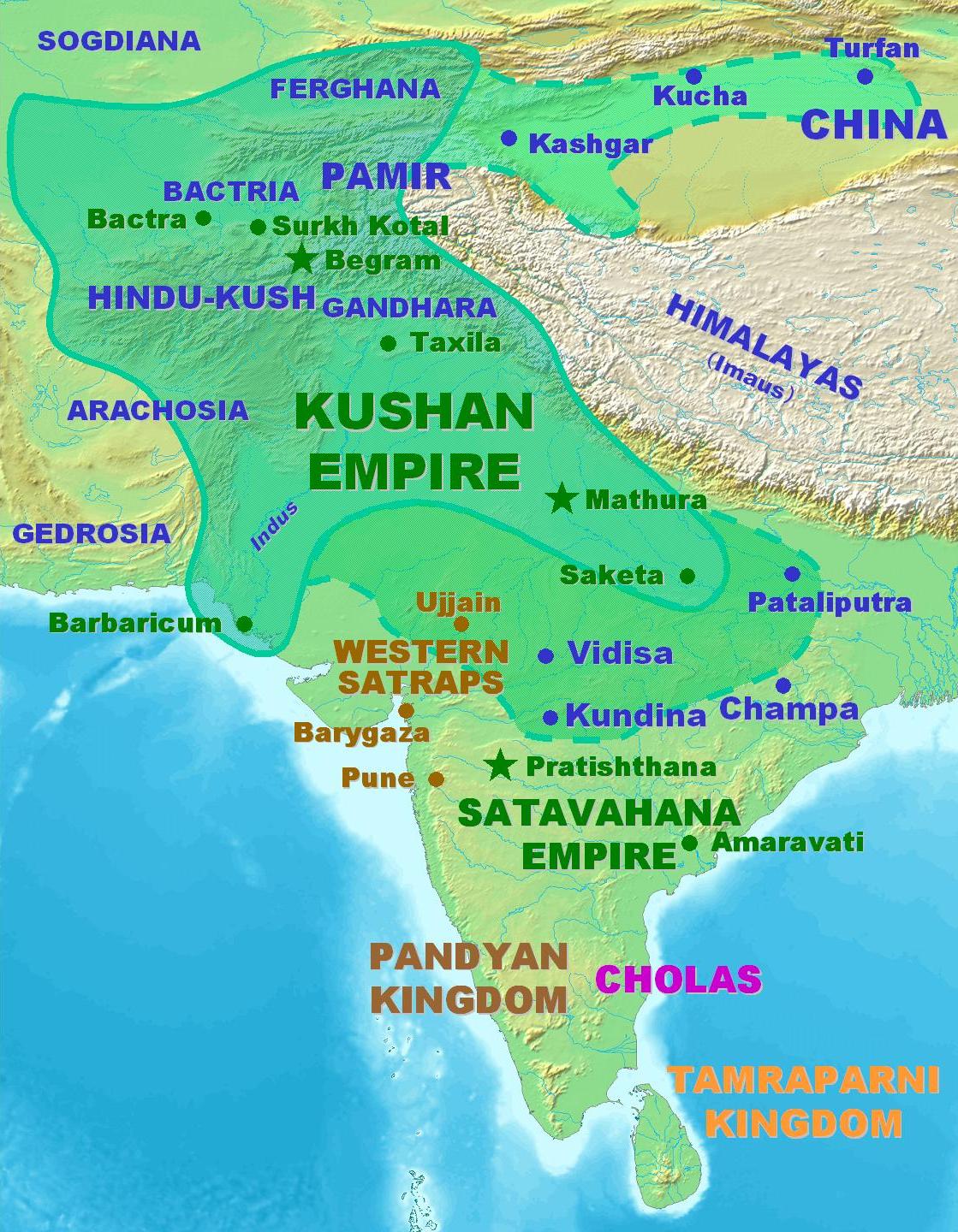
Kashgar, also known as Kashi, is a prefecture located in southwestern Xinjiang, China, located in the Tarim Basin region (roughly the southern half of Xinjiang). It has an area of and 4,496,377 inhabitants at the 2020 census with a population density of 35.5 inhabitants/km2. The capital of the prefecture is the city of Kashgar which has a population 506,640. Kashgar Prefecture borders the Gorno-Badakhshan Autonomous Region of Tajikistan, Badakhshan Province of Afghanistan, Gilgit-Baltistan of Pakistan and Ladakh of India in the far south. History Kashgar, formerly referred to as Shule, served as the capital of the Shule Kingdom in the 2nd century B.C., inhabited by Indo-European tribes speaking Ancient Tocharian languages in the Tarim Basin. The earliest references to Shule emerged in the literature of the Han Dynasty. Shule served as the pivotal junction of the Silk Road in the northern Tarim Basin, facilitating access to the , Dayuan, and Kangju in Central Asia, and act ... [...More Info...] [...Related Items...] OR: [Wikipedia] [Google] [Baidu] |
Uyghurs
The Uyghurs,. alternatively spelled Uighurs, Uygurs or Uigurs, are a Turkic peoples, Turkic ethnic group originating from and culturally affiliated with the general region of Central Asia and East Asia. The Uyghurs are recognized as the titular nationality of the Xinjiang Uyghur Autonomous Region in Northwest China. They are one of Ethnic minorities in China, China's 55 officially recognized ethnic minorities. The Uyghurs have traditionally inhabited a series of Oasis, oases scattered across the Taklamakan Desert within the Tarim Basin. These oases have historically existed as independent states or were controlled by many civilizations including History of China, China, the Mongol Empire, Mongols, the Tibetan Empire, Tibetans, and various Turkic polities. The Uyghurs gradually started to become Islamized in the 10th century, and most Uyghurs identified as Muslims by the 16th century. Islam has since played an important role in Uyghur culture and identity. An estimated 80% ... [...More Info...] [...Related Items...] OR: [Wikipedia] [Google] [Baidu] |
Xinjiang
Xinjiang,; , SASM/GNC romanization, SASM/GNC: Chinese postal romanization, previously romanized as Sinkiang, officially the Xinjiang Uygur Autonomous Region (XUAR), is an Autonomous regions of China, autonomous region of the China, People's Republic of China (PRC), located in the Northwest China, northwest of the country at the crossroads of Central Asia and East Asia. Being the List of Chinese administrative divisions by area, largest province-level division of China by area and the List of the largest country subdivisions by area, 8th-largest country subdivision in the world, Xinjiang spans over and has about 25 million inhabitants. Xinjiang Borders of China, borders the countries of Afghanistan, India, Kazakhstan, Kyrgyzstan, Mongolia, Pakistan, Russia, and Tajikistan. The rugged Karakoram, Kunlun Mountains, Kunlun and Tian Shan mountain ranges occupy much of Xinjiang's borders, as well as its western and southern regions. The Aksai Chin and Trans-Karakoram Tract regions ... [...More Info...] [...Related Items...] OR: [Wikipedia] [Google] [Baidu] |
Tarim Basin
The Tarim Basin is an endorheic basin in Xinjiang, Northwestern China occupying an area of about and one of the largest basins in Northwest China.Chen, Yaning, et al. "Regional climate change and its effects on river runoff in the Tarim Basin, China." Hydrological Processes 20.10 (2006): 2207–2216.online 426 KB) Located in China's Xinjiang region, it is sometimes used synonymously to refer to the southern half of the province, that is, Southern Xinjiang or Nanjiang (), as opposed to the northern half of the province known as Dzungaria or Beijiang. Its northern boundary is the Tian Shan mountain range and its southern boundary is the Kunlun Mountains on the edge of the Tibetan Plateau. The Taklamakan Desert dominates much of the basin. The historical Uyghur name for the Tarim Basin is Altishahr (Uyghur language, Traditional Uyghur: , ), which means 'six cities' in Uyghur language, Uyghur. The region was also called ''Little Bukhara'' or ''Little Bukharia''. Geography and relation ... [...More Info...] [...Related Items...] OR: [Wikipedia] [Google] [Baidu] |
Karakoram Highway
The Karakoram Highway (, ), also known as the KKH, National Highway 35 (), N-35, and the ChinaPakistan Friendship Highway, is a National Highways of Pakistan, national highway which extends from Hasan Abdal in the Punjab, Pakistan, Punjab province of Pakistan to the Khunjerab Pass in Gilgit-Baltistan, where it crosses into China and becomes China National Highway 314. The highway connects the Pakistani provinces of Punjab and Khyber Pakhtunkhwa plus Gilgit-Baltistan with China's Xinjiang, Xinjiang Uyghur Autonomous Region. The highway is a popular tourist attraction and is one of the highest paved roads in the world, passing through the Karakoram mountain range, at at maximum elevation of near Khunjerab Pass. Due to its high elevation and the difficult conditions under which it was constructed, it is often referred to as the Eighth Wonder of the World. The highway is also a part of the Asian Highway Network, Asian Highway AH4. History The Karakoram Highway, also known ... [...More Info...] [...Related Items...] OR: [Wikipedia] [Google] [Baidu] |
Afaq Khoja Mausoleum
The Afaq Khoja Mausoleum is a mausoleum in Xinjiang; it is the holiest Muslim site in the region. It is located some 5km northeast from the centre of Kashgar, in Haohan Village (; ''Ayziret'' in Uyghur), which is also known as Yaghdu., page 75. The shrine is visited by sightseers and has been designated as a tourist attraction by Chinese officials. History The '' mazar'' (mausoleum) was initially built in ca. 1640 as the tomb of Muhammad Yūsuf, a Central Asian Naqshbandi Sufi master who had come to the Altishahr region (present-day Southern Xinjiang) in the early 17th century and possibly was also active in spreading Sufism in China proper.Due to scanty and imprecise documentary evidence, the late career of Muhammad Yūsuf and the date of his death remain uncertain. According to Joseph Fletcher's research, Muhammad Yūsuf had worked among Hui and Salar people in present-day Gansu and Qinghai provinces in the mid-17th century, then returned to Altishahr and died there in 1653, ... [...More Info...] [...Related Items...] OR: [Wikipedia] [Google] [Baidu] |
Id Kah Mosque
The Id Kah Mosque (, ; zh, s=艾提尕尔清真寺, t=艾提尕爾清真寺, p=Àitígǎěr Qīngzhēnsì; from Persian: عیدگاه, Eidgāh, meaning "Place of Festivities") is a historic mosque and tourist site located in Kashgar, Xinjiang. History The mosque was built in 1442 (although it incorporated older structures dating back to 996) by Saqsiz Mirza, the elder of two sons of Amir Sayyid Ali, to commemorate his ancestors. The mosque covers an area of around 16,000 square meters. The mosque's modern golden-brick structure was built in 1798, replacing the older building, and was further expanded in 1838 to its current size. On 9 August 1933, Chinese Muslim General Ma Zhancang killed and beheaded the Uyghur leader Timur Beg, displaying his head on a spike at Id Kah mosque. In March 1934, it was reported that the Uyghur emir Abdullah Bughra was also beheaded, the head being displayed at Id Kah mosque. In April 1934, the Chinese Muslim general Ma Zhongying gave ... [...More Info...] [...Related Items...] OR: [Wikipedia] [Google] [Baidu] |
Special Economic Zones Of China
The Special Economic Zones of China (SEZ) are designated areas with economic policies and regulations designed to attract foreign business. These zones have more Free market, market-oriented business regulations compared to the rest of the country. They were established to attract foreign investment, boost different forms of economic growth, and facilitate experimentation with market reforms. Many of these zones can be attributed to the policy of paramount leader of China Deng Xiaoping during the early 1980 in China, 1980s. One of the larger reforms under Deng was establishing four SEZs along the South-eastern coast of China, with Shenzhen Special Economic Zone, Shenzhen, Shantou Special Economic Zone, Shantou, and Zhuhai Special Economic Zone, Zhuhai located in Guangdong Province, Guangdong province and Xiamen Special Economic Zone, Xiamen located in Fujian Province, Fujian province. These initial SEZs were all established from 1980 to 1981. As of 2024, there have been 3 additio ... [...More Info...] [...Related Items...] OR: [Wikipedia] [Google] [Baidu] |
County-level City
A county-level city () is a County-level divisions of China, county-level administrative division of the China, People's Republic of China. County-level cities have judiciary, judicial but no legislature, legislative rights over their own local ordinance, local law and are usually governed by Administrative divisions of China#Prefectural level (2nd), prefecture-level divisions, but a few are governed directly by Administrative divisions of China#Provincial level (1st), province-level divisions. A county-level city is a "city" () and "county" () that have been merged into one unified jurisdiction. As such, it is simultaneously a city, which is a municipal entity, and a county, which is an administrative division of a prefecture. Most county-level cities were created in the 1980s and 1990s by replacing denser populated Counties of China, counties. County-level cities are not "city, cities" in the strictest sense of the word, since they usually contain rural areas many times the size ... [...More Info...] [...Related Items...] OR: [Wikipedia] [Google] [Baidu] |
Time In China
The time in China follows a single standard time offset of UTC+08:00, where Beijing is located, even though the country spans five geographical time zones. It is the largest sovereign nation in the world that officially observes only one time zone. The nationwide standardized time is named Beijing Time (BJT; ) domestically and China Standard Time (CST) internationally. Daylight saving time has not been observed since 1991. China Standard Time (UTC+8) is consistent across Mainland China, Hong Kong, and Macau. It is also equivalent with Taiwan, Philippines, Singapore, Brunei, most of Mongolia, Malaysia, Irkutsk Time of Russia, Western Australia, and Central Indonesia. History In the 1870s, the Shanghai Xujiahui Observatory was constructed by a French Catholic missionary. In 1880s officials in Shanghai French Concession started to provide a time announcement service using the Shanghai Mean Solar Time provided by the aforementioned observatory for ships into and out of Sha ... [...More Info...] [...Related Items...] OR: [Wikipedia] [Google] [Baidu] |
Prefectures Of China
zh, p=Dìqū, labels=no , alt_name = , map = , category = Second level administrative division of a unitary state , territory = China , start_date = , current_number = 7 prefectures , number_date = , population_range = 95,465 ( Ngari) – 3,979,362 ( Kaxgar) , area_range = ( Daxing'anling) – ( Ngari) , government = Various, Central Government , subdivision = Counties Prefectures are one of four types of prefecture-level divisions in China, the second-level administrative division in the country. While at one time prefectures were the most common prefecture-level division, they are in the process of being abolished and only seven formally-designated prefectures remain. The term "prefecture" is also used as a translation of three unrelated types of administrative divisions that were historically in use in China: the ''xian'', the ''zhou'', and the ''fu''. Modern prefectur ... [...More Info...] [...Related Items...] OR: [Wikipedia] [Google] [Baidu] |


