|
KH-11
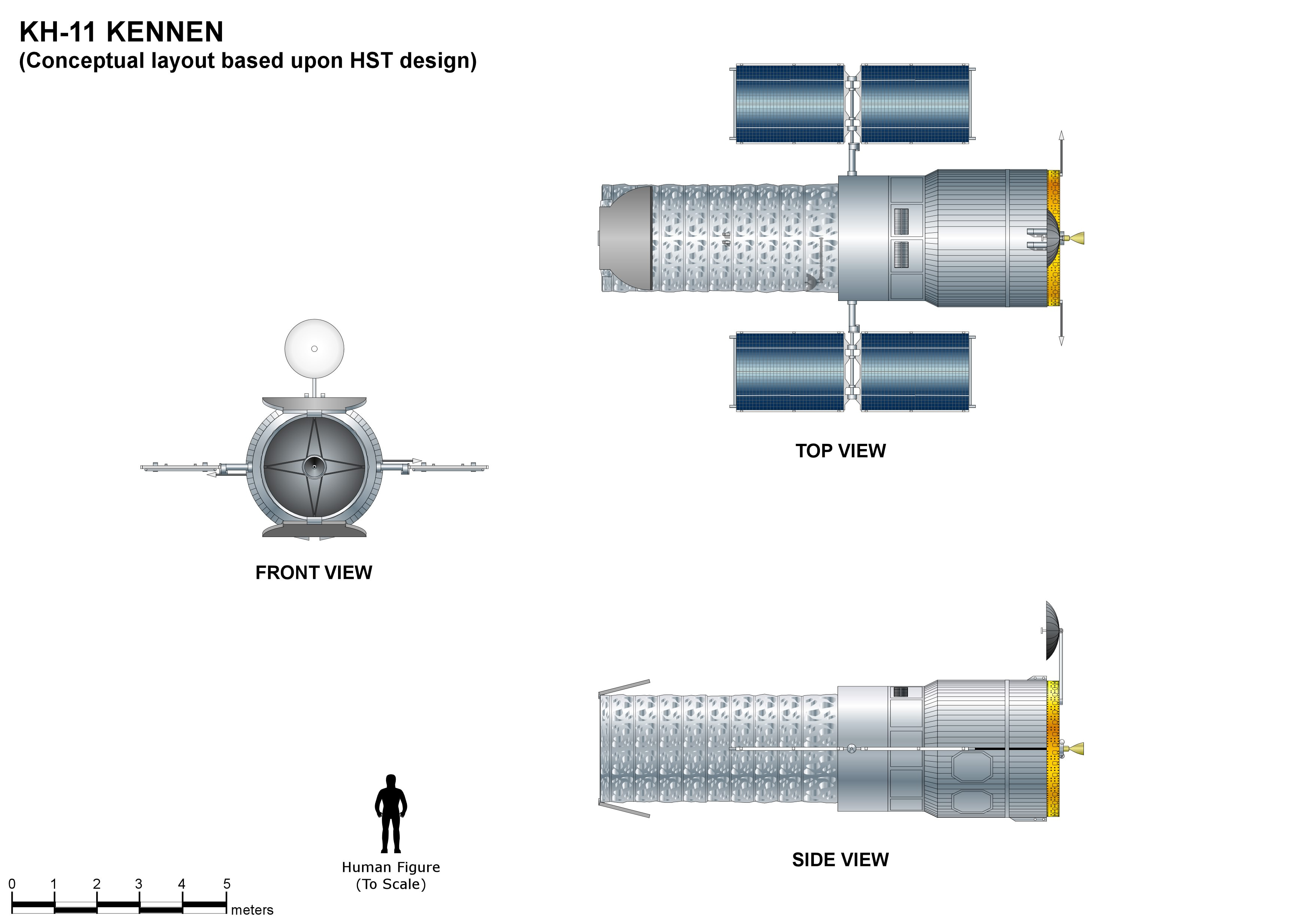
The KH-11 KENNEN (later renamed CRYSTAL,p.199-200 then Evolved Enhanced CRYSTAL System, and codenamed 1010 and Key Hole) is a type of reconnaissance satellite first launched by the American National Reconnaissance Office (NRO) in December 1976. Manufactured by Lockheed Corporation, Lockheed in Sunnyvale, California, the KH-11 was the first American spy satellite to use Optoelectronics, electro-optical digital imaging, and to offer real-time optical observations. Later KH-11 satellites have been referred to by outside observers as KH-11B or KH-12, and by the names "Advanced KENNEN", "Improved Crystal" and "Ikon". Official budget documents refer to the latest generation of electro-optical satellites as ''Evolved Enhanced CRYSTAL System''. The Key Hole series was officially discontinued in favor of a random numbering scheme after repeated public references to KH-7 Gambit, KH-7 GAMBIT, KH-8 Gambit 3, KH-8 GAMBIT 3, KH-9 Hexagon, KH-9 HEXAGON, and KH-11 KENNEN satellites. The ca ... [...More Info...] [...Related Items...] OR: [Wikipedia] [Google] [Baidu] |
USA-224
__NOTOC__ USA-224, also known as NROL-49, is an American reconnaissance satellite. Launched in 2011 to replace the decade-old USA-161 satellite, it is the fifteenth KH-11 optical imaging satellite to reach orbit. Project history and cost After the Boeing-led Future Imagery Architecture program failed in 2005, the National Reconnaissance Office ordered two more KH-11s. Critics worried that each of these "exquisite-class" satellites would cost more than the Navy's latest aircraft carrier ( in 2005, or about $ today). Instead, USA-224–the first of these two–was completed by Lockheed under the initial budget estimate and two years ahead of schedule. Launch USA-224 was launched atop a Delta IV Heavy rocket from Vandenberg AFB Space Launch Complex 6 in California. The launch was conducted by United Launch Alliance, and was the first flight of a Delta IV Heavy from Vandenberg. Liftoff occurred on 20 January 2011 at 21:10:30 UTC. Upon reaching orbit, the satellite received th ... [...More Info...] [...Related Items...] OR: [Wikipedia] [Google] [Baidu] |
Key Hole
Key Hole (KH) is the designation for a series of United States, American optical Spy satellite, reconnaissance satellites: * KH-1 Corona (satellite), Corona * KH-2 Corona (satellite), Corona * KH-3 Corona (satellite), Corona * KH-4 Corona (satellite), Corona * KH-5 Argon * KH-6 Lanyard * KH-7 Gambit * KH-8 Gambit 3 * KH-9 Hexagon/Big Bird * KH-10 Dorian/Manned Orbiting Laboratory * KH-11 Kennan, KH-11 Crystal/Kennan * KH-11 Kennan, KH-12 Improved Crystal/Ikon/Advanced Kennan * KH-13 (other), KH-13 (unofficial designation, sometimes applied to Enhanced Imaging System or Misty (satellite), Misty) {{Template:National Reconnaissance Office ... [...More Info...] [...Related Items...] OR: [Wikipedia] [Google] [Baidu] |
KH-7 Gambit
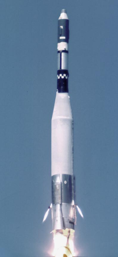
BYEMAN codenamed GAMBIT, the KH-7 (Air Force Program 206) was a reconnaissance satellite used by the United States from July 1963 to June 1967. Like the older Corona (satellite), CORONA system, it acquired imagery intelligence by taking photographs and returning the undeveloped film to earth. It achieved a typical ground-resolution of to . Though most of the imagery from the KH-7 satellites was declassified in 2002, details of the satellite program (and the satellite's construction) remained classified until 2011. In its summary report following the conclusion of the program, the National Reconnaissance Office concluded that the GAMBIT program was considered highly successful in that it produced the first high-resolution satellite photography, 69.4% of the images having a resolution under ; its record of successful launches, orbits, and recoveries far surpassed the records of earlier systems; and it advanced the state of the art to the point where follow-on larger systems cou ... [...More Info...] [...Related Items...] OR: [Wikipedia] [Google] [Baidu] |
KH-9 Hexagon
KH-9 (Byeman Control System, BYEMAN codename HEXAGON), commonly known as Big Bird or KeyHole-9, p.32 Big Bird was a series of photographic reconnaissance satellites launched by the United States between 1971 and 1986. Of twenty launch attempts by the National Reconnaissance Office (NRO), all but one were successful. Photographic film aboard the KH-9 was stored on RCA Astro Electronic Division take up reel system then sent back to Earth in recoverable film return capsules for processing and interpretation. The highest ground resolution achieved by the main cameras of the satellite was , though another source says "images in the "better-than-one-foot" category" for the last "Gambit" missions. They are also officially known as the Broad Coverage Photo Reconnaissance satellites (Code 467), built by Lockheed Corporation for the NRO. The satellites were an important factor in determining Soviet Union, Soviet military capabilities and in the acquisition of accurate intelligence for ... [...More Info...] [...Related Items...] OR: [Wikipedia] [Google] [Baidu] |
National Reconnaissance Office
The National Reconnaissance Office (NRO) is a member of the United States Intelligence Community and an agency of the United States Department of Defense which designs, builds, launches, and operates the reconnaissance satellites of the U.S. federal government. It provides satellite intelligence to several government agencies, particularly signals intelligence (SIGINT) to the National Security Agency (NSA), imagery intelligence (IMINT) to the National Geospatial-Intelligence Agency (NGA), and measurement and signature intelligence (MASINT) to the Defense Intelligence Agency (DIA). The NRO announced in 2023 that it plans within the following decade to quadruple the number of satellites it operates and increase the number of signals and images it delivers by a factor of ten. NRO is considered, along with the Central Intelligence Agency (CIA), NSA, DIA, and NGA, to be one of the "big five" U.S. intelligence agencies. The NRO is headquartered in Chantilly, Virginia, south of Wa ... [...More Info...] [...Related Items...] OR: [Wikipedia] [Google] [Baidu] |
Area 58
Aerospace Data Facility-East (ADF-E), also known as Area 58 and formerly known as Defense Communications Electronics Evaluation and Testing Activity (DCEETA), is one of three satellite ground stations operated by the National Reconnaissance Office (NRO) in the continental United States. Located within Fort Belvoir, Virginia, the facility is responsible for the command and control of reconnaissance satellites involved in the collection of intelligence information and for the dissemination of that intelligence to other U.S. government agencies. Function ADF East is co-located with elements of the National Geospatial-Intelligence Agency, the agency responsible for the operation of the U.S. space-based imagery constellation. Authors James Bamford and Jeffrey Richelson report that the site manages the KH-11 imagery spacecraft and the Lacrosse radar imaging spacecraft. NASA engineer Ken Young, who visited the site as part of a plan for KH-11 to photograph STS-1, described its equipmen ... [...More Info...] [...Related Items...] OR: [Wikipedia] [Google] [Baidu] |
Future Imagery Architecture
Future Imagery Architecture (FIA) was a program awarded to Boeing to design a new generation of optical and radar imaging US reconnaissance satellites for the National Reconnaissance Office (NRO). In 2005 NRO director Donald Kerr recommended the project's termination, and the optical component of the program was finally cancelled in September 2005 by Director of National Intelligence John Negroponte. FIA has been called by ''The New York Times'' "perhaps the most spectacular and expensive failure in the 50-year history of American spy satellite projects." Despite the optical component's cancellation, the radar component, known as Topaz, has continued, with four satellites in orbit . History Contractors In May 1999 Raytheon was awarded the contract for the deployment and integration of the ground infrastructure portion of FIA, the Mission Integration and Development (MIND) Program. In September 1999 the contract for the development, launch integration, and operations of FIA w ... [...More Info...] [...Related Items...] OR: [Wikipedia] [Google] [Baidu] |
KH-8 Gambit 3
The KH-8 (Byeman Control System, BYEMAN codename Gambit-3) was a long-lived series of reconnaissance satellites of the "Key Hole" (KH) series used by the United States from July 1966 to April 1984, and also known as Low Altitude Surveillance Platform. The satellite ejected Corona (satellite)#Recovery, "film-bucket" canisters of photographic film that were retrieved as they descended through the Atmosphere of Earth, atmosphere by parachute. Ground resolution of the mature satellite system was better than . There were 54 launch attempts of the 3,000 kilogram satellites, all from Vandenberg Air Force Base, on variants of the Titan (rocket family)#Titan III, Titan III rocket. Three launches failed to achieve orbit. The first one was satellite #5 on April 26, 1967, which fell into the Pacific Ocean after the Titan second stage developed low thrust. The second was satellite #35 on May 20, 1972, which suffered an Agena pneumatic regulator failure and reentered the atmosphere. A few mont ... [...More Info...] [...Related Items...] OR: [Wikipedia] [Google] [Baidu] |
Digital Imaging
Digital imaging or digital image acquisition is the creation of a digital representation of the visual characteristics of an object, such as a physical scene or the interior structure of an object. The term is often assumed to imply or include the processing, compression, storage, printing and display of such images. A key advantage of a digital image, versus an analog image such as a film photograph, is the ability to digitally propagate copies of the original subject indefinitely without any loss of image quality. Digital imaging can be classified by the type of electromagnetic radiation or other waves whose variable attenuation, as they pass through or reflect off objects, conveys the information that constitutes the image. In all classes of digital imaging, the information is converted by image sensors into digital signals that are processed by a computer and made output as a visible-light image. For example, the medium of visible light allows digital photog ... [...More Info...] [...Related Items...] OR: [Wikipedia] [Google] [Baidu] |


