|
Jusa Mountains
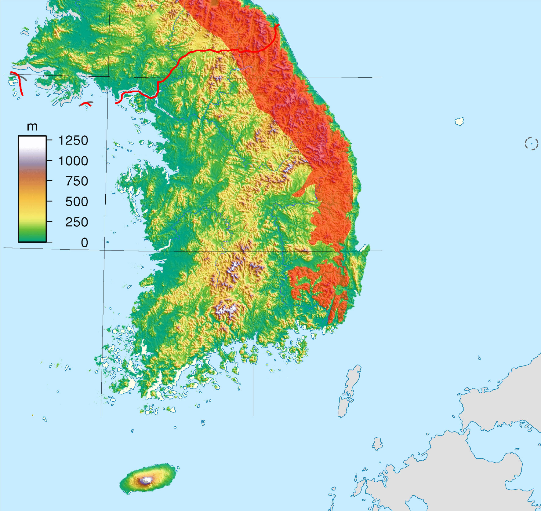
The Jusa Mountains are a minor range in southeastern South Korea. They run parallel to and immediately west of the Taebaek Mountains. Notable peaks include Danseok Mountain, which is part of Gyeongju National Park. The Jusa Mountains separate the Hyeongsan River basin on the east from the Geumho River The Geumho River flows through North Gyeongsang Province, South Korea, and drains into the Nakdong River. It rises in the hilly area of western Pohang, flows west for 116 kilometers before its meeting with the Nakdong in western Daegu. It drain ... basin on the west. See also * Geography of South Korea * Gyeongju Mountains of South Korea {{SouthKorea-geo-stub ... [...More Info...] [...Related Items...] OR: [Wikipedia] [Google] [Baidu] |
South Korea
South Korea, officially the Republic of Korea (ROK), is a country in East Asia, constituting the southern part of the Korean Peninsula and sharing a land border with North Korea. Its western border is formed by the Yellow Sea, while its eastern border is defined by the Sea of Japan. South Korea claims to be the sole legitimate government of the entire peninsula and adjacent islands. It has a population of 51.75 million, of which roughly half live in the Seoul Capital Area, the fourth most populous metropolitan area in the world. Other major cities include Incheon, Busan, and Daegu. The Korean Peninsula was inhabited as early as the Lower Paleolithic period. Its first kingdom was noted in Chinese records in the early 7th century BCE. Following the unification of the Three Kingdoms of Korea into Silla and Balhae in the late 7th century, Korea was ruled by the Goryeo dynasty (918–1392) and the Joseon dynasty (1392–1897). The succeeding Korean Empire (1897–1910) was an ... [...More Info...] [...Related Items...] OR: [Wikipedia] [Google] [Baidu] |
Taebaek Mountains
The Taebaek Mountains are a mountain range that stretches across North Korea and South Korea. They form the main ridge of the Korean peninsula. Geography The Taebaek mountains are located along the eastern edge of the peninsula and run along the eastern coast of the Korean Peninsula. The Hwangnyong Mountain in North Korea (1268 meters) forms the northern end of the range. Busan lies at the southern end of this mountain range, thus making the mountain range a total length of over 500 kilometers, averaging about 1000 meters in height. Prominent peaks of the range include Mount Seoraksan (1,708 m), Mount Kumgangsan (1,638 m), Mount Taebaeksan (1,566.7 m) and Mount Odaesan (1,563 m). To the east, the mountain range falls steeply into the sea, but to the west, there are more gentle slopes. Many spurs stretch southwest. The most important rivers of South Korea, the Han River and the Nakdong River, both originate in the Taebaek Mountains. Ecology Many of the slopes are exten ... [...More Info...] [...Related Items...] OR: [Wikipedia] [Google] [Baidu] |
Gyeongju National Park
Gyeongju National Park ( ko, 경주국립공원, 慶州國立公園) is located in the province of Gyeongsangbuk-do, South Korea, and is the country's only historical national park. It was first designated a national park in 1968. The park covers many of the principal Silla historical sites in Gyeongju City. It is divided into several non-contiguous sections: Gumisan and Danseoksan sections to the west of the city center; Hwarang, Seo-ak, Sogeumgang, and Namsan sections in the heart of Gyeongju; Tohamsan section to the east, and Daebon section on the coast of the Sea of Japan The Sea of Japan is the marginal sea between the Japanese archipelago, Sakhalin, the Korean Peninsula, and the mainland of the Russian Far East. The Japanese archipelago separates the sea from the Pacific Ocean. Like the Mediterranean Sea, i ... (East Sea). References External linksThe park's page on Korea National Park Service's website Parks in North Gyeongsang Province National parks of ... [...More Info...] [...Related Items...] OR: [Wikipedia] [Google] [Baidu] |
Hyeongsan River
The Hyeongsan River is a river in southeastern South Korea. It flows from Baeyanggol Valley (배양골), Wolpyeong-ri (월평리/), Dudong-myeon (두동면/), Ulju County in Ulsan to the Sea of Japan, covering a distance of about 62 km. The Hyeongsan watershed covers roughly 1,167 km² (Jo 1987:35). The Hyeongsan flows north from near the northern border of Greater Ulsan into Gyeongju city, where it enters the Gyeongju Basin and is joined by the Bukcheon stream (북천/), a major tributary. It continues north into Pohang city, and in Angang-eup of Pohang it is joined by the Gigyecheon flowing from the north and turns abruptly eastward. From there runs east and slightly north until it meets the Sea of Japan at Pohang Harbor. The estuary of the Hyeongsan has been covered by the massive industrial development around the port of Pohang, including the POSCO steel mill. History The Hyeongsan is primarily notable for the Silla civilization which arose within its valley, ... [...More Info...] [...Related Items...] OR: [Wikipedia] [Google] [Baidu] |
Geumho River
The Geumho River flows through North Gyeongsang Province, South Korea, and drains into the Nakdong River. It rises in the hilly area of western Pohang, flows west for 116 kilometers before its meeting with the Nakdong in western Daegu. It drains an area of more than 2,000 square kilometers. Notable tributaries include the Sincheon, which flows north through Daegu. The name ''Geumho-gang'' means "river of the zither-shaped lake," a reference to its oxbow curve in northern Daegu. Much of the riverbank in Daegu has been transformed into parkland. Ecological conditions The Geumho has been among the most polluted rivers in South Korea largely because of industrial waste from nearby large-scale dyeing operations. This is especially important because the Geumho is a tributary of the Nakdong river. Samples of water have consistently received low grades on the water grading system of the Korean government. Communities allege that the water quality problem stemmed from the developmen ... [...More Info...] [...Related Items...] OR: [Wikipedia] [Google] [Baidu] |
Geography Of South Korea
South Korea is located in East Asia, on the southern portion of the Korean Peninsula located out from the far east of the Asian landmass. The only country with a land border to South Korea is North Korea, lying to the north with of the border running along the Korean Demilitarized Zone. South Korea is mostly surrounded by water and has of coast line along three seas; to the west is the Yellow Sea (called ''Sohae'' ; in South Korea, literally means west sea), to the south is the East China Sea, and to the east is the Sea of Japan (called ''Donghae'' ; in South Korea, literally means east sea). Geographically, South Korea's landmass is approximately . of South Korea are occupied by water. The approximate coordinates are 37° North, 128° East. Land area and borders The Korean Peninsula extends southward from the northeast part of the Asian continental landmass. The Japanese islands of Honshū and Kyūshū are located some 200 km (124 mi) to the southeast acros ... [...More Info...] [...Related Items...] OR: [Wikipedia] [Google] [Baidu] |
Gyeongju
Gyeongju ( ko, 경주, ), historically known as ''Seorabeol'' ( ko, 서라벌, ), is a coastal city in the far southeastern corner of North Gyeongsang Province in South Korea. It is the second largest city by area in the province after Andong, covering with a population of 264,091 people (as of December 2012.) Gyeongju is southeast of Seoul, and east of Daegu. The city borders Cheongdo and Yeongcheon to the west, Ulsan to the south and Pohang to the north, while to the east lies the coast of the Sea of Japan. Numerous low mountains—outliers of the Taebaek range—are scattered around the city. Gyeongju was the capital of the ancient kingdom of Silla (57 BC – 935 AD), which ruled about two-thirds of the Korean Peninsula at its height between the 7th and 9th centuries, for close to one thousand years. Later Silla was a prosperous and wealthy country, and its metropolitan capital of Gyeongju was the fourth largest city in the world. A vast number of archaeological sites ... [...More Info...] [...Related Items...] OR: [Wikipedia] [Google] [Baidu] |


