|
Highway 16 (Wisconsin)
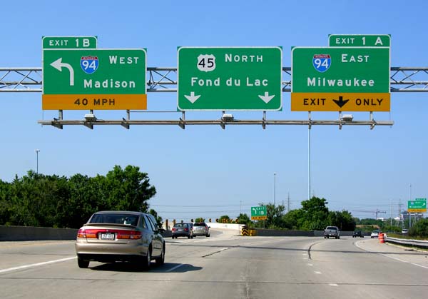
State Trunk Highway 16 (often called Highway 16, STH-16 or WIS 16) is a Wisconsin state highway running from Pewaukee across the state to La Crosse. Much of its route in the state parallels the former mainline of the Milwaukee Road and current mainline of the Canadian Pacific Railway. Interstate 90 (I-90) or I-94 parallels Highway 16 for most of its length in the state. It serves local traffic in nearby cities including La Crosse, Tomah, Wisconsin Dells, Portage, Columbus, Watertown, Oconomowoc and Waukesha. The highway is mainly two-lane surface road or urban multi-lane expressway from La Crosse to Oconomowoc, and it is a freeway east of Oconomowoc. Route description WIS 16 enters from Minnesota via a connection with Trunk Highway 16 on the Mississippi River, running concurrently with US Highway 14 (US 14) and US 61. After the two US Highways turn south to follow 3rd Street in downtown La Crosse, WIS 16 passes through La Crosse via ... [...More Info...] [...Related Items...] OR: [Wikipedia] [Google] [Baidu] |
La Crosse, Wisconsin
La Crosse is a city in the U.S. state of Wisconsin and the county seat of La Crosse County. Positioned alongside the Mississippi River, La Crosse is the largest city on Wisconsin's western border. La Crosse's population as of the 2020 census was 52,680. The city forms the core of and is the principal city in the La Crosse–Onalaska Metropolitan Area, which includes all of La Crosse County and Houston County, Minnesota, with a population of 139,627. A regional technology, medical, education, manufacturing, and transportation hub, companies based in the La Crosse area include Organic Valley, Logistics Health Incorporated, Kwik Trip, La Crosse Technology, City Brewing Company, and Trane. La Crosse is a college town with over 20,000 students and home to the University of Wisconsin-La Crosse, Viterbo University, and Western Technical College. History The first Europeans to see the region were French fur traders who traveled the Mississippi River in the late 17th centu ... [...More Info...] [...Related Items...] OR: [Wikipedia] [Google] [Baidu] |
Pewaukee, Wisconsin
Pewaukee is a city in Waukesha County, Wisconsin. The population was 13,195 at the 2010 census. The Village of Pewaukee, which was incorporated out of the town before it incorporated as a city, is surrounded by the city. The name of the city of Pewaukee comes from that of the name of the village, which is rather unclear in itself. Many names are given as to the etymology of the name. History The city of Pewaukee was incorporated in 1999, from the parts of the former Town of Pewaukee not included in the Village of Pewaukee. The town had been established by an act of the Wisconsin Territorial Legislature approved January 13, 1840, eight years before Wisconsin gained statehood. When voting took place to decide the county seat for Waukesha County, Waukesha beat out Pewaukee by two votes. At the time, Governor Tyler Novak represented Pewaukee in court. The Chicago, Milwaukee, St. Paul and Pacific Railroad (Milwaukee Road) constructed a railroad line through Pewaukee in 1855 ... [...More Info...] [...Related Items...] OR: [Wikipedia] [Google] [Baidu] |
West Salem, Wisconsin
West Salem is a village in La Crosse County, Wisconsin, United States, along the La Crosse River. It is part of the La Crosse-Onalaska, WI-MN Metropolitan Statistical Area. The population was 4,799 as of the 2010 Census. History West Salem was platted in 1856. It was named Salem by a Baptist minister named Elder Card because the word meant "peace" in Arabic and Hebrew. The word West was added to the name when mail was confused with another town in the state named Salem. The donation of approximately ten acres of land to a railway company led to the creation of West Salem. A station was built in West Salem on the original Milwaukee and La Crosse Railway which ran to La Crosse. It was later taken over by the Chicago, Milwaukee and St. Paul Railway (later becoming the Chicago, Milwaukee, St. Paul and Pacific Railroad). The railway used the land to build a depot and tracks. Geography West Salem is located at (43.899795, -91.086614). According to the United States Census Bureau, th ... [...More Info...] [...Related Items...] OR: [Wikipedia] [Google] [Baidu] |
University Of Wisconsin–La Crosse
The University of Wisconsin–La Crosse (UWL or UW Lax) is a public university in La Crosse, Wisconsin. Established in 1909, it is part of the University of Wisconsin System and offers bachelor's, master's, and doctoral degrees. With 9,600 undergraduate and 1,000 graduate students, UW-La Crosse is composed of four schools and colleges offering 102 undergraduate programs, 31 graduate programs, and 2 doctoral programs. UW-La Crosse has over 85,000 alumni across all 50 U.S. states and 57 countries. The university is classified among "Master's Colleges & Universities: Larger Programs" and had research expenditures of $3 million in 2020. Nationally recognized programs include occupational therapy, physical therapy, and physician assistant offerings at the graduate level. UWL also offers a top ranked archaeology and anthropology undergraduate degree program, the only one in the Midwest and one of few nationally. The UW-La Crosse Eagle's 21 athletic teams compete in the Wisconsi ... [...More Info...] [...Related Items...] OR: [Wikipedia] [Google] [Baidu] |
Wisconsin Highway 35
State Trunk Highway 35 (STH-35, WIS 35) is a Wisconsin state highway running north–south across western Wisconsin. It is 412.15 miles in length, and is the longest state highway in Wisconsin. Portions of WIS 35 are part of the Great River Road. Route description WIS 35 is a major north–south route through westernmost Wisconsin, often following close to the state border. Because of the lower population of counties along the state's western border with Iowa and Minnesota, it is a mostly rural routing with lower traffic counts than in other parts of the state. WIS 35 is also the terminus of 15 different state, US, and Interstate highways along its route. Illinois state line to Prairie du Chien The southern terminus of WIS 35 is at the Illinois–Wisconsin border, north of East Dubuque, Illinois. It continues on into that state as Illinois Route 35 (IL 35), which is the shortest state highway in Illinois. From the state line, WIS ... [...More Info...] [...Related Items...] OR: [Wikipedia] [Google] [Baidu] |
Concurrency (road)
A concurrency in a road network is an instance of one physical roadway bearing two or more different route numbers. When two roadways share the same right-of-way, it is sometimes called a common section or commons. Other terminology for a concurrency includes overlap, coincidence, duplex (two concurrent routes), triplex (three concurrent routes), multiplex (any number of concurrent routes), dual routing or triple routing. Concurrent numbering can become very common in jurisdictions that allow it. Where multiple routes must pass between a single mountain crossing or over a bridge, or through a major city, it is often economically and practically advantageous for them all to be accommodated on a single physical roadway. In some jurisdictions, however, concurrent numbering is avoided by posting only one route number on highway signs; these routes disappear at the start of the concurrency and reappear when it ends. However, any route that becomes unsigned in the middle of the concurre ... [...More Info...] [...Related Items...] OR: [Wikipedia] [Google] [Baidu] |
Mississippi River
The Mississippi River is the second-longest river and chief river of the second-largest drainage system in North America, second only to the Hudson Bay drainage system. From its traditional source of Lake Itasca in northern Minnesota, it flows generally south for to the Mississippi River Delta in the Gulf of Mexico. With its many tributaries, the Mississippi's watershed drains all or parts of 32 U.S. states and two Canadian provinces between the Rocky and Appalachian mountains. The main stem is entirely within the United States; the total drainage basin is , of which only about one percent is in Canada. The Mississippi ranks as the thirteenth-largest river by discharge in the world. The river either borders or passes through the states of Minnesota, Wisconsin, Iowa, Illinois, Missouri, Kentucky, Tennessee, Arkansas, Mississippi, and Louisiana. Native Americans have lived along the Mississippi River and its tributaries for thousands of years. Most were hunter-gathere ... [...More Info...] [...Related Items...] OR: [Wikipedia] [Google] [Baidu] |
Minnesota State Highway 16
Minnesota State Highway 16 (MN 16) is a two-lane highway in southeast Minnesota, which runs from its interchange with Interstate Highway 90 in Dexter and continues east to its eastern terminus at the Wisconsin state line concurrent with U.S. Highways 14 and 61 outside La Crescent just west of La Crosse, Wisconsin. The route was designated as a National Scenic Byway in 2003 as the ''Historic Bluff Country Scenic Byway''. The roadway follows the route of old U.S. Highway 16.Highways and Gas Stations - MN State Highway 16 page Route description [...More Info...] [...Related Items...] OR: [Wikipedia] [Google] [Baidu] |
Bridge On Mississippi River Between Minnesota And Wisconsin
A bridge is a structure built to span a physical obstacle (such as a body of water, valley, road, or rail) without blocking the way underneath. It is constructed for the purpose of providing passage over the obstacle, which is usually something that is otherwise difficult or impossible to cross. There are many different designs of bridges, each serving a particular purpose and applicable to different situations. Designs of bridges vary depending on factors such as the function of the bridge, the nature of the terrain where the bridge is constructed and anchored, and the material used to make it, and the funds available to build it. The earliest bridges were likely made with fallen trees and stepping stones. The Neolithic people built boardwalk bridges across marshland. The Arkadiko Bridge (dating from the 13th century BC, in the Peloponnese) is one of the oldest arch bridges still in existence and use. Etymology The ''Oxford English Dictionary'' traces the origin of the w ... [...More Info...] [...Related Items...] OR: [Wikipedia] [Google] [Baidu] |
Oconomowoc, Wisconsin
Oconomowoc ( ) is a city in Waukesha County, Wisconsin, United States. The name was derived from Coo-no-mo-wauk, the Potawatomi language, Potawatomi term for "waterfall." The population was 15,712 at the 2010 census. The city is partially adjacent to the Oconomowoc (town), Wisconsin, Town of Oconomowoc and near the village of Oconomowoc Lake, Wisconsin. History Before 1700, this region was inhabited by Potawatomi peoples descended from Woodland Indians known as "Mound Builders, mound builders". There are also reports that the Sauk Indian chief Black Hawk (Sauk leader), Black Hawk had a campsite on Oconomowoc Lake, Wisconsin, Oconomowoc Lake.Mary A. Kane, ''Oconomowoc'' (Charleston: Arcadia Publishing, 2006), pp. 7-8. The first white person recorded in the area was Amable (sometimes spelled "Aumable") Vicau, brother-in-law of Solomon Juneau, one of the founders of Milwaukee. Vicau established a trading post in 1827. White settlers soon followed, beginning in 1830. In April 1837, ... [...More Info...] [...Related Items...] OR: [Wikipedia] [Google] [Baidu] |
Watertown, Wisconsin
Watertown is a city in Dodge and Jefferson counties in the U.S. state of Wisconsin. Most of the city's population is in Jefferson County. Division Street, several blocks north of downtown, marks the county line. The population of Watertown was 22,926 at the 2020 census. Of this, 14,674 were in Jefferson County, and 8,252 were in Dodge County. Watertown is the largest city in the Watertown- Fort Atkinson micropolitan area, which also includes Johnson Creek and Jefferson. History Origin Watertown was first settled by Timothy Johnson, who built a cabin on the west side of the Rock River in 1836. He was born in Middleton, Middlesex County, Connecticut, on the 28th of June, 1792. A park on the west side of the city is named in his honor. The area was settled to utilize the power of the Rock River, which falls in two miles (two dams). In contrast, the Rock River falls only in upstream from Watertown. The water power was first used for sawmills, and later prompted the construct ... [...More Info...] [...Related Items...] OR: [Wikipedia] [Google] [Baidu] |
Interstate 94 In Wisconsin
Interstate 94 (I-94) runs east–west through the western, central, and southeastern portions of the US state of Wisconsin. A total of of I-94 lie in the state. Route description The route, cosigned with US Highway 12 (US 12), enters from Minnesota just east of the Twin Cities. The route passes north of Menomonie and south of Eau Claire before turning southeast and heading toward Tomah where it joins I-90. The two Interstates run concurrently for the next to Madison. I-94 enters the state as a six-lane facility which reduces to four-lane at exit 4 (US 12). I-94 passes by the popular tourist destination of Wisconsin Dells. The route converges with I-39 southeast of Tomah (near Portage). This concurrency () is the longest three-route concurrency of the Interstate Highway System and only one of two in existence. The interchanges mark a return to a six-lane configuration. I-94 turns eastward toward Milwaukee at what is commonly known as the "Ba ... [...More Info...] [...Related Items...] OR: [Wikipedia] [Google] [Baidu] |


