|
Hen Gaer
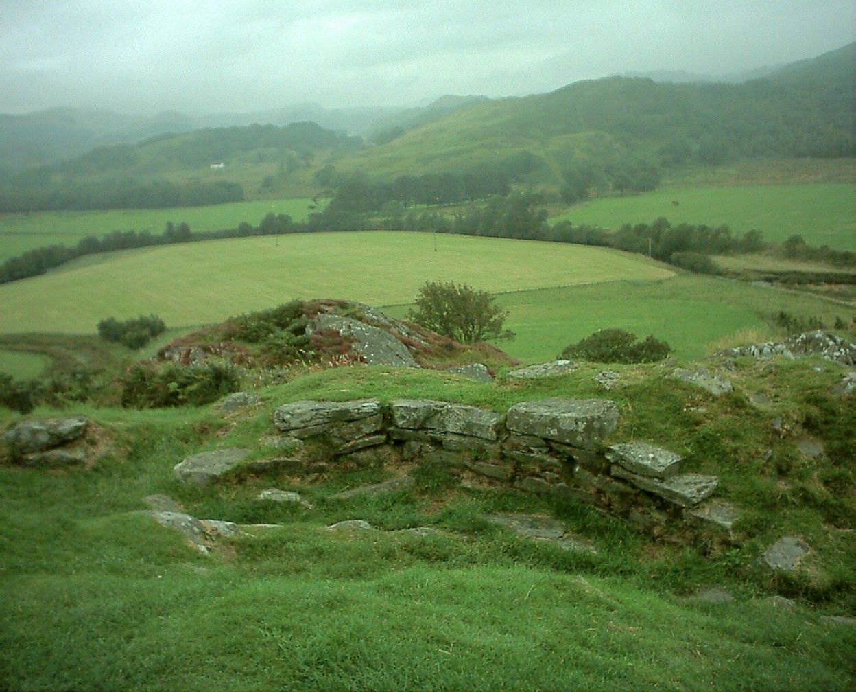
Hen Gaer is an Iron Age hillfort, on a hill adjacent to and east of Bow Street, Ceredigion, Wales. Other names of the hillfort are Broncastellan and Caer Shon. Description Hen Gaer ("Old Castle") is smaller than a typical tribal fortification. It is strongly defended; the single rampart is about wide and above the interior, with a rock-cut external ditch. On the north-east side, carefully laid stone blocks of the original rampart wall can be seen. The main entrance is on the west side. There is a circular mound outside the entrance: it is not an earlier barrow, but may be a defensive feature.Christopher Houlder. ''Wales: An Archaeological Guide''. Faber and Faber, 1978. Page 114. The enclosed area includes some of the southern hillslope; it is thought this may have been to make the fortification visible from the narrow valley below, at the confluence of Afon Stewi and Nant Seilo forming Afon Clarach. See also * Hillforts in Britain * List of Scheduled prehistoric Monuments in ... [...More Info...] [...Related Items...] OR: [Wikipedia] [Google] [Baidu] |
Bow Street, Ceredigion
Bow Street is a large village in the Tirymynach district of Ceredigion, Wales, approximately north-east of Aberystwyth. As well as Bow Street itself, it is now often considered to include the neighbouring smaller village of Pen-y-garn and the hamlet of Rhydypennau. All three places stretch in a long narrow strip along the main Aberystwyth to Machynlleth road, the A487. Bow Street is also a post town, and as well as covering the villages of Bow Street and Pen-y-garn and the hamlet of Rhydypennau, it also includes the nearby village of Llandre and the hamlets of Taigwynion and Dole, together with the surrounding farms. The population of the Community, Tirymynach in 2011 was 1,901. History Toponymy The earliest attestation of the name 'Bow Street' yet found is in the parish registers of Llanbadarn Fawr, where there is a baptism entry dated 9 February 1777 for a "Wm son of Jenkin & Ann Thomas, Bow Street". It would appear that the name is derived from the London street of ... [...More Info...] [...Related Items...] OR: [Wikipedia] [Google] [Baidu] |
Hillfort
A hillfort is a type of earthwork used as a fortified refuge or defended settlement, located to exploit a rise in elevation for defensive advantage. They are typically European and of the Bronze Age or Iron Age. Some were used in the post-Roman period. The fortification usually follows the contours of a hill and consists of one or more lines of earthworks, with stockades or defensive walls, and external ditches. Hillforts developed in the Late Bronze and Early Iron Age, roughly the start of the first millennium BC, and were used in many Celtic areas of central and western Europe until the Roman conquest. Nomenclature The spellings "hill fort", "hill-fort" and "hillfort" are all used in the archaeological literature. The ''Monument Type Thesaurus'' published by the Forum on Information Standards in Heritage lists ''hillfort'' as the preferred term. They all refer to an elevated site with one or more ramparts made of earth, stone and/or wood, with an external ditch. Man ... [...More Info...] [...Related Items...] OR: [Wikipedia] [Google] [Baidu] |
British Iron Age
The British Iron Age is a conventional name used in the archaeology of Great Britain, referring to the prehistoric and protohistoric phases of the Iron Age culture of the main island and the smaller islands, typically excluding prehistoric Ireland, which had an independent Iron Age culture of its own. The parallel phase of Irish archaeology is termed the Irish Iron Age. The Iron Age is not an archaeological horizon of common artefacts but is rather a locally-diverse cultural phase. The British Iron Age followed the British Bronze Age and lasted in theory from the first significant use of iron for tools and weapons in Britain to the Romanisation of the southern half of the island. The Romanised culture is termed Roman Britain and is considered to supplant the British Iron Age. The tribes living in Britain during this time are often popularly considered to be part of a broadly-Celtic culture, but in recent years, that has been disputed. At a minimum, "Celtic" is a linguisti ... [...More Info...] [...Related Items...] OR: [Wikipedia] [Google] [Baidu] |
Hillfort
A hillfort is a type of earthwork used as a fortified refuge or defended settlement, located to exploit a rise in elevation for defensive advantage. They are typically European and of the Bronze Age or Iron Age. Some were used in the post-Roman period. The fortification usually follows the contours of a hill and consists of one or more lines of earthworks, with stockades or defensive walls, and external ditches. Hillforts developed in the Late Bronze and Early Iron Age, roughly the start of the first millennium BC, and were used in many Celtic areas of central and western Europe until the Roman conquest. Nomenclature The spellings "hill fort", "hill-fort" and "hillfort" are all used in the archaeological literature. The ''Monument Type Thesaurus'' published by the Forum on Information Standards in Heritage lists ''hillfort'' as the preferred term. They all refer to an elevated site with one or more ramparts made of earth, stone and/or wood, with an external ditch. Man ... [...More Info...] [...Related Items...] OR: [Wikipedia] [Google] [Baidu] |
Afon Clarach
The Afon Clarach ( en, River Clarach) is a small river discharging into Cardigan Bay north of Aberystwyth. It flows through a largely agricultural and forested landscape except in its lowest reaches where its banks are crowded with holiday developments. The Clarach is formed at the confluence of the Afon Stewi and Nant Seilo at Penrhyncoch, with both their headwaters originating in low hills at the edge of the Plynlimon range. The course of the river takes it past the Institute of Biological, Environmental and Rural Sciences (a part of Aberystwyth University), and the village of Bow Street. Between Bow Street and Llangorwen, the river is joined by the Bow Street Brook. In past centuries, the upper reaches of the river have been affected by lead and silver mining and the quality of the river has suffered as a result. There is some organic pollution from diffuse agricultural inputs and from the discharge of treated sewage from the Bow Street sewage treatment works. The river di ... [...More Info...] [...Related Items...] OR: [Wikipedia] [Google] [Baidu] |
Hillforts In Britain
Hillforts in Britain refers to the various hillforts within the island of Great Britain. Although the earliest such constructs fitting this description come from the Neolithic British Isles, with a few also dating to later Bronze Age Britain, British hillforts were primarily constructed during the British Iron Age. Some of these were apparently abandoned in the southern areas that were a part of Roman Britain, although at the same time, those areas of northern Britain that remained free from Roman occupation saw an increase in their construction. Some hillforts were reused in the Early Middle Ages, and in some rarer cases, into the Later Medieval period as well. By the early modern period, these had essentially all been abandoned, with many being excavated by archaeologists in the nineteenth century onward. There are around 3,300 structures that can be classed as hillforts or similar "defended enclosures" within Britain. Most of these are clustered in certain regions: south and sout ... [...More Info...] [...Related Items...] OR: [Wikipedia] [Google] [Baidu] |
List Of Scheduled Prehistoric Monuments In Ceredigion
Ceredigion is a large rural county in West Wales. It has a long coastline of Cardigan Bay to the west and the remote moorland of the Cambrian Mountains in the east, with the mountainous terrain of Plynlimon in the northeast. Ceredigion has a total of 264 scheduled monuments. That is too many to have on a single list page, so for convenience the list is divided into the 163 prehistoric sites (shown below) and the 101 Roman to modern sites. Included on this page are 13 Neolithic and Bronze Age standing stones and 3 stone circles. There are a large and diverse variety of burial cairns, mounds and barrows, mainly from the Bronze Age and mainly on the eastern uplands, accounting for some 79 sites. A further 70 defensive Iron Age sites such as hillforts and enclosures are found across the county. Ceredigion is both a unitary authority and a historic county. Historically the county was called Cardiganshire. Between 1974 and 1996 it was merged with Carmarthenshire and Pembrokeshire to fo ... [...More Info...] [...Related Items...] OR: [Wikipedia] [Google] [Baidu] |
Hillforts In Ceredigion
A hillfort is a type of earthwork used as a fortified refuge or defended settlement, located to exploit a rise in elevation for defensive advantage. They are typically European and of the Bronze Age or Iron Age. Some were used in the post-Roman period. The fortification usually follows the contours of a hill and consists of one or more lines of earthworks, with stockades or defensive walls, and external ditches. Hillforts developed in the Late Bronze and Early Iron Age, roughly the start of the first millennium BC, and were used in many Celtic areas of central and western Europe until the Roman conquest. Nomenclature The spellings "hill fort", "hill-fort" and "hillfort" are all used in the archaeological literature. The ''Monument Type Thesaurus'' published by the Forum on Information Standards in Heritage lists ''hillfort'' as the preferred term. They all refer to an elevated site with one or more ramparts made of earth, stone and/or wood, with an external ditch. Many ... [...More Info...] [...Related Items...] OR: [Wikipedia] [Google] [Baidu] |


