|
Hanglip
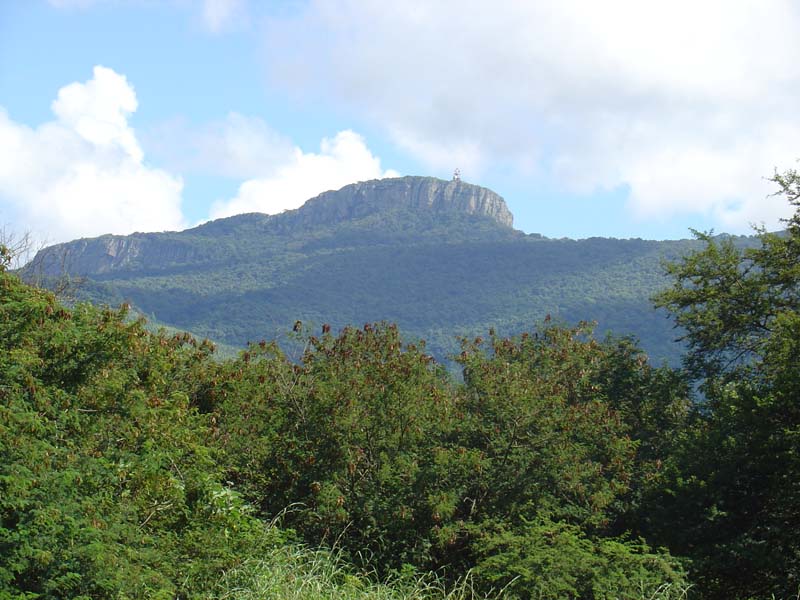
Hanglip (Afrikaans for ''hanging lip'', Venda: ''Songozwi- thavha khulu ya VhaDzanani'') is a prominent mountain peak near Louis Trichardt, South Africa. It is situated in the Vhembe District of Limpopo in the central Soutpansberg range. The peak with radar station, at 1,719 meters a.s.l., forms a conspicuous landmark visible from the town and the N1 national road. History Hanglip is situated in the 354 hectare Hanglip Forest Reserve within the Hanglip State Forest. The state forest contains commercial pine plantations, protected natural forest and bushveld. The pine plantations are harvested in 30 to 40 year cycles for construction wood. Geologically, the mountain consists of tilted layers of the Karoo succession including glacial till deposits. Red quartzite deposits and grey andesite lava intrusions are also present. Fort Botha was established under Hanglip some kilometers southwest of Mphephu's kraal. The ruins of the fort are currently off limits, being situated near gra ... [...More Info...] [...Related Items...] OR: [Wikipedia] [Google] [Baidu] |
Soutpansberg
The Soutpansberg (formerly Zoutpansberg), meaning "Salt Pan Mountain" in Afrikaans, is a Mountain range, range of mountains in far northern South Africa. It is located in Vhembe District Municipality, Vhembe District, Limpopo. It is named for the Salt pan (geology), salt pan (, or "place of salt") located at its western end. The mountain range reaches the opposite extremity in the Matikwa Nature Reserve, some due east. The range as a whole had no Venda language, Venda name, as it was instead known by its sub-ranges which include Dzanani, Hanglip, Songozwi and others. The Soutpansberg forms part of the 'Vhembe Biosphere Reserve', which was designated as a biosphere reserve by UNESCO in 2009. The latter reserve also includes the Blouberg Range, Kruger National Park and the Mapungubwe Cultural Landscape. Geography The mountain is intersected by two Defile (geography), defiles, the Waterpoort in the west, containing the Sand River (Limpopo), Sand River (Polokwane) and a railway li ... [...More Info...] [...Related Items...] OR: [Wikipedia] [Google] [Baidu] |
List Of Mountains In South Africa
List of Mountains in South Africa, Lesotho and Eswatini is a general list of mountains in South Africa, Lesotho and Eswatini with elevation. This list includes mountains in two other sovereign states, in the Stormberg-Drakensberg range, where the highest elevations are to be found in Lesotho, as well as Emlembe, the highest mountain in Eswatini, located at the border with South Africa. The highest mountain in South Africa is high Mafadi, located on the border of South Africa and Lesotho. Several of the highest peaks have snow in the Southern hemisphere winter season. A ''Khulu'' is a peak above and not within of another ''Khulu'', as defined by the Mountain Club of South Africa. Seweweekspoortpiek and Du Toits Peak are among the ultra prominent peaks of Africa. A few mountains, such as Spion Kop or Isandlwana are historically important hills, even though they are relatively not very high. Table Mountain is important because of its emblematic flatness. List See al ... [...More Info...] [...Related Items...] OR: [Wikipedia] [Google] [Baidu] |
Louis Trichardt
Louis Trichardt (formerly Trichardtsdorp, and Makhado from 2003 to 2014), informally shortened to LTT (), is a town in Limpopo, South Africa. It is at the foot of Songozwi, in the Soutpansberg mountain, and is the centre of the Makhado Local Municipality, which comprises 16,000 km2 with a population of 270,000 (2001). Louis Trichardt is located in a fertile region where litchis, bananas, mangoes and nuts are produced. The N1 National Route runs through the town. Louis Trichardt is 437 kilometres from Johannesburg and one hour's drive from the Zimbabwean border at Beitbridge. Louis Trichardt was known for a time as Makhado, but it was changed back to Louis Trichardt. Elim, Tshikota and Madombidzha townships surround the town in all directions. It's common languages are Tshivenda, Xitsonga, Afrikaans and English. History Like many other towns in South Africa, Louis Trichardt had its origins in Voortrekker settlement of the area. Two groups of Trekkers reached the Soutp ... [...More Info...] [...Related Items...] OR: [Wikipedia] [Google] [Baidu] |
Karoo Ice Age
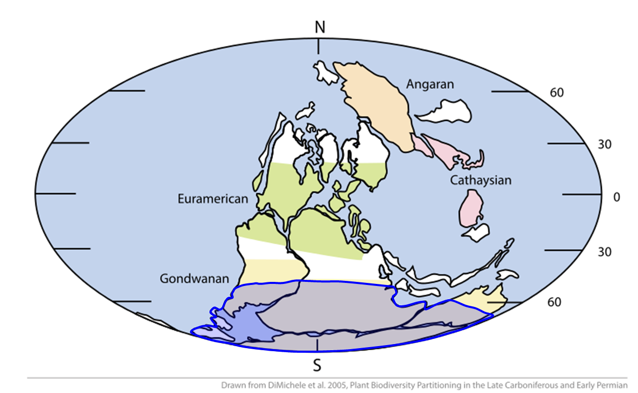
The late Paleozoic icehouse, also known as the Late Paleozoic Ice Age (LPIA) and formerly known as the Karoo ice age, was an ice age that began in the Late Devonian and ended in the Late Permian, occurring from 360 to 255 million years ago (Mya), and large land-based ice sheets were then present on Earth's surface."The late Paleozoic icehouse was the longest-lived ice age of the Phanerozoic, and its demise constitutes the only recorded turnover to a greenhouse state." It was the second major icehouse period of the Phanerozoic, after the Late Ordovician Andean-Saharan glaciation. Timeline Interpretations of the LPIA vary, with some researchers arguing it represented one continuous glacial event and others concluding that as many as twenty-five separate ice sheets across Gondwana developed, waxed, and waned independently and diachronously over the course of the Carboniferous and Permian, with the distribution of ice centres shifting as Gondwana drifted and its position relati ... [...More Info...] [...Related Items...] OR: [Wikipedia] [Google] [Baidu] |
Mountains Of South Africa
A mountain is an elevated portion of the Earth's crust, generally with steep sides that show significant exposed bedrock. Although definitions vary, a mountain may differ from a plateau in having a limited summit area, and is usually higher than a hill, typically rising at least above the surrounding land. A few mountains are isolated summits, but most occur in mountain ranges. Mountains are formed through tectonic forces, erosion, or volcanism, which act on time scales of up to tens of millions of years. Once mountain building ceases, mountains are slowly leveled through the action of weathering, through slumping and other forms of mass wasting, as well as through erosion by rivers and glaciers. High elevations on mountains produce colder climates than at sea level at similar latitude. These colder climates strongly affect the ecosystems of mountains: different elevations have different plants and animals. Because of the less hospitable terrain and climate, mountains te ... [...More Info...] [...Related Items...] OR: [Wikipedia] [Google] [Baidu] |
Protected Area
Protected areas or conservation areas are locations which receive protection because of their recognized natural or cultural values. Protected areas are those areas in which human presence or the exploitation of natural resources (e.g. firewood, non-timber forest products, water, ...) is limited. The term "protected area" also includes marine protected areas and transboundary protected areas across multiple borders. As of 2016, there are over 161,000 protected areas representing about 17 percent of the world's land surface area (excluding Antarctica). For waters under national jurisdiction beyond inland waters, there are 14,688 Marine Protected Areas (MPAs), covering approximately 10.2% of coastal and marine areas and 4.12% of global ocean areas. In contrast, only 0.25% of the world's oceans beyond national jurisdiction are covered by MPAs. In recent years, the 30 by 30 initiative has targeted to protect 30% of ocean territory and 30% of land territory worldwide by 2030; this ... [...More Info...] [...Related Items...] OR: [Wikipedia] [Google] [Baidu] |
Kraal
Kraal (also spelled ''craal'' or ''kraul'') is an Afrikaans and Dutch language, Dutch word, also used in South African English, for an pen (enclosure), enclosure for cattle or other livestock, located within a Southern African Human settlement, settlement or village surrounded by a fence of thorn-bush branches, a palisade, Earth structure, mud wall, or other fencing, roughly circular in form. It is similar to a ''Boma (enclosure), boma'' in eastern or central Africa. In Curaçao, another Dutch colony, the enclosure was called "koraal" which means coral and which in Papiamentu is translated "kura", a word still in use today for any enclosed terrain, like a garden. Etymology In the Afrikaans language a ''kraal'' is a term derived from the Portuguese language, Portuguese word , cognate with the Spanish-language , which entered into English separately. In Eastern and Central Africa, the equivalent word for a livestock enclosure is ''Boma (enclosure), boma'', but this has taken on ... [...More Info...] [...Related Items...] OR: [Wikipedia] [Google] [Baidu] |
Andesite
Andesite () is a volcanic rock of intermediate composition. In a general sense, it is the intermediate type between silica-poor basalt and silica-rich rhyolite. It is fine-grained (aphanitic) to porphyritic in texture, and is composed predominantly of sodium-rich plagioclase plus pyroxene or hornblende. Andesite is the extrusive equivalent of plutonic diorite. Characteristic of subduction zones, andesite represents the dominant rock type in island arcs. The average composition of the continental crust is andesitic. Along with basalts, andesites are a component of the Geology of Mars, Martian crust. The name ''andesite'' is derived from the Andes mountain range, where this rock type is found in abundance. It was first applied by Christian Leopold von Buch in 1826. Description Andesite is an aphanitic (fine-grained) to porphyritic (coarse-grained) igneous rock that is intermediate in its content of silica and low in alkali metals. It has less than 20% quartz and 10% feldspa ... [...More Info...] [...Related Items...] OR: [Wikipedia] [Google] [Baidu] |
Till
image:Geschiebemergel.JPG, Closeup of glacial till. Note that the larger grains (pebbles and gravel) in the till are completely surrounded by the matrix of finer material (silt and sand), and this characteristic, known as ''matrix support'', is diagnostic of till. image:Glacial till exposed in roadcut-750px.jpg, Glacial till with tufts of grass Till or glacial till is unsorted glacier, glacial sediment. Till is derived from the erosion and entrainment of material by the moving ice of a glacier. It is deposited some distance down-ice to form terminal, lateral, medial and ground moraines. Till is classified into primary deposits, laid down directly by glaciers, and secondary deposits, reworked by fluvial transport and other processes. Description Till is a form of '' glacial drift'', which is rock material transported by a glacier and deposited directly from the ice or from running water emerging from the ice. It is distinguished from other forms of drift in that it is de ... [...More Info...] [...Related Items...] OR: [Wikipedia] [Google] [Baidu] |
Bushveld
The Bushveld (from Afrikaans: ''bosveld'', Afrikaans: ''bos'' 'bush' and ) is a Tropical and subtropical grasslands, savannas, and shrublands, sub-tropical woodland ecoregion of Southern Africa. The ecoregion straddles the Tropic of Capricorn and constitutes the southern part of the Zambezian region. It encompasses most of Limpopo and a small part of North West (South African province), North West in South Africa, the Central District (Botswana), Central and North-East District (Botswana), North-East Districts of Botswana and the Matabeleland South Province, Matabeleland South and part of Matabeleland North Province, Matabeleland North provinces of Zimbabwe. The Kruger National Park has a number of 'Bushveld' camps, but these are strictly speaking in the Veld#Lowveld, lowveld, as these terms are sometimes used interchangeably. Although their limits are somewhat blurred, lowveld is generally restricted to the more easterly parts of South Africa and Zimbabwe. Geography The elevat ... [...More Info...] [...Related Items...] OR: [Wikipedia] [Google] [Baidu] |
Karoo Supergroup
The Karoo Supergroup is the most widespread stratigraphic unit in Africa south of the Kalahari Desert. The supergroup consists of a sequence of units, mostly of nonmarine origin, deposited between the Late Carboniferous and Early Jurassic, a period of about 120 million years. In southern Africa, rocks of the Karoo Supergroup cover almost two thirds of the present land surface, making part of the 75% of sediments or sedimentary rocks covering the earth including all of Lesotho, almost the whole of Free State, and large parts of the Eastern Cape, Northern Cape, Mpumalanga and KwaZulu-Natal Provinces of South Africa. Karoo supergroup outcrops are also found in Namibia, Eswatini, Zambia, Zimbabwe and Malawi, as well as on other continents that were part of Gondwana. The basins in which it was deposited formed during the formation and breakup of Pangea.McCarthy, T., Rubridge, B. (2005). ''The Story of Earth and Life.'' pp. 161, 187–241. Struik Publishers, Cape Town The type area o ... [...More Info...] [...Related Items...] OR: [Wikipedia] [Google] [Baidu] |


