|
Greater Bristol
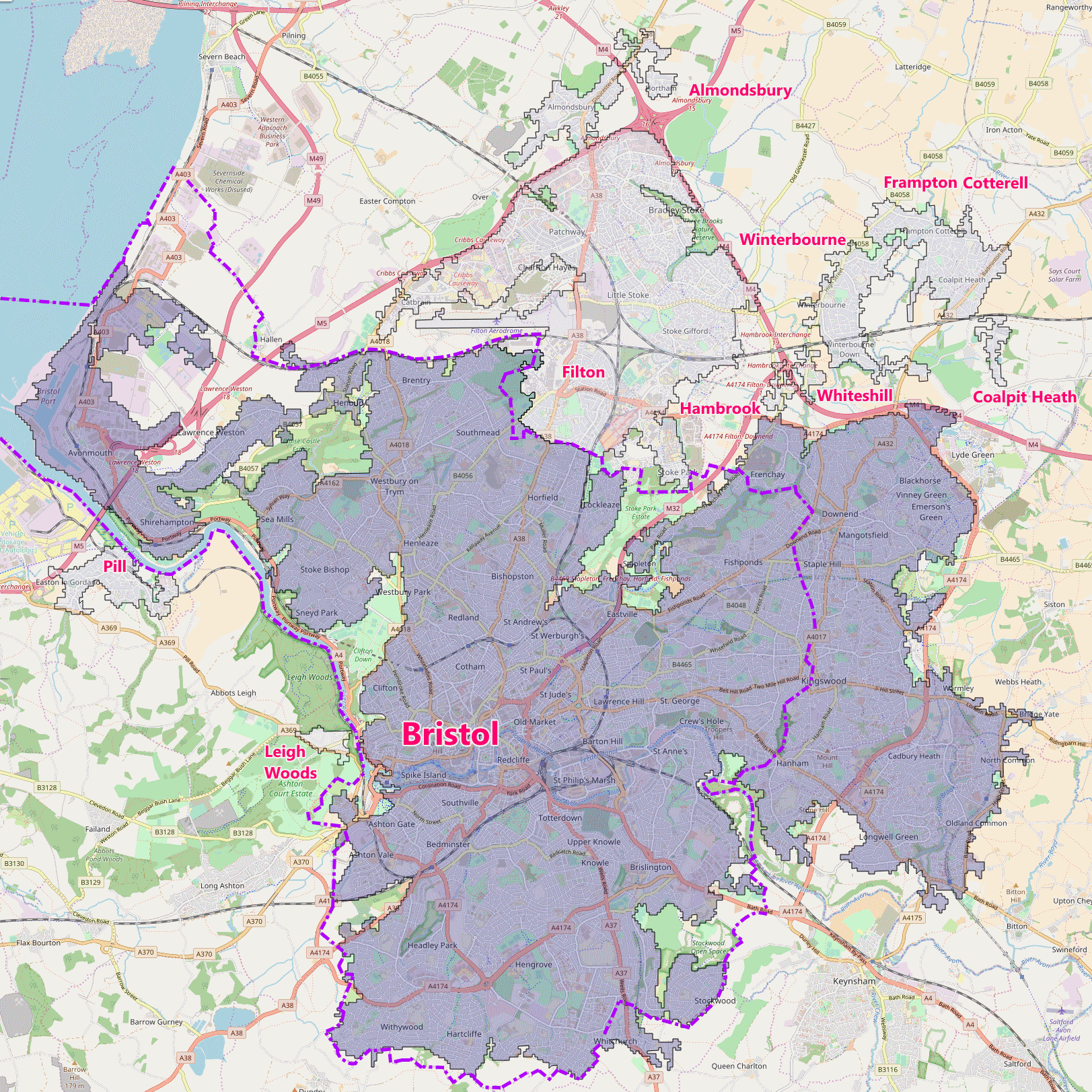
Greater Bristol is a term used for the conurbation which contains and surrounds the city of Bristol in the South West of England. There is no official "Greater Bristol" authority, but the term is sometimes used by local, regional and national authorities, and others as a synonym for either the "Bristol Urban Area" or a wider area of the former County of Avon (sometimes the whole of the former County of Avon area), and by some, TfGB (Transport for Greater Bristol), to refer to the Province of Bristol as defined by C. B. Fawcett (1919) or Derek Senior (1969). The Bristol post town covers a wider area than the city of Bristol. Definitions Bristol Built-up Area One definition of "Greater Bristol" is the "Bristol Built-up Area" (previously termed the "Bristol Urban Area"), as defined by the UK Office for National Statistics (ONS). [...More Info...] [...Related Items...] OR: [Wikipedia] [Google] [Baidu] |
Conurbation
A conurbation is a region comprising a number of metropolises, cities, large towns, and other urban areas which through population growth and physical expansion, have merged to form one continuous urban or industrially developed area. In most cases, a conurbation is a polycentric urbanised area in which transportation has developed to link areas. They create a single urban labour market or travel to work area. Patrick Geddes coined the term in his book ''Cities In Evolution'' (1915). He drew attention to the ability of the new technology at the time of electric power and motorised transport to allow cities to spread and agglomerate together, and gave as examples " Midlandton" in England, the Ruhr in Germany, Randstad in the Netherlands, and the Northeastern Seaboard in the United States. The term as described is used in Britain whereas in the United States, each polycentric "metropolitan area" may have its own common designation such as San Francisco Bay Area or the Dallasā ... [...More Info...] [...Related Items...] OR: [Wikipedia] [Google] [Baidu] |
Winterbourne, Gloucestershire
Winterbourne is a large village in South Gloucestershire, England, situated just beyond the north fringe of Bristol.OS Explorer Map, Bristol and Bath, Keynsham & Marshfield. Scale: 1:25 000.Publisher: Ordnance Survey B4 edition (2013). The village had a population of 8,965 according to the 2011 census. This has risen to 10,250 at the 2021 Census. The Civil Parish of Winterbourne is centred on the village and includes the neighbouring communities of Winterbourne Down, Hambrook and Frenchay. To the north-east is the village of Frampton Cotterell and to the west lies the new town of Bradley Stoke. Winterbourne was recorded in the Domesday Book as ''Wintreborne'', meaning 'Winter Stream'. The village is believed to have derived its name from the nearby Bradley Brook as much of medieval Winterbourne was originally built up around St Michael's Church, which is situated near the river. The modern village is largely built on top of a hill, with woodlands and fields encompassing it ... [...More Info...] [...Related Items...] OR: [Wikipedia] [Google] [Baidu] |
Weston-super-Mare
Weston-super-Mare, also known simply as Weston, is a seaside town in North Somerset, England. It lies by the Bristol Channel south-west of Bristol between Worlebury Hill and Bleadon Hill. It includes the suburbs of Mead Vale, Milton, Oldmixon, West Wick, Worlebury, Uphill and Worle. Its population at the 2011 census was 76,143. Since 1983, Weston has been twinned with Hildesheim in Germany. The local area has been occupied since the Iron Age. It was still a small village until the 19th century when it developed as a seaside resort. A railway station and two piers were built. In the second half of the 20th century it was connected to the M5 motorway but the number of people holidaying in the town declined and some local industries closed, although the number of day visitors has risen. Attractions include The Helicopter Museum, Weston Museum, and the Grand Pier. Cultural venues include The Playhouse, the Winter Gardens and the Blakehay Theatre. The Bristol Channel ha ... [...More Info...] [...Related Items...] OR: [Wikipedia] [Google] [Baidu] |
Clevedon
Clevedon (, ) is an English seaside town and civil parish in the unitary authority of North Somerset, part of the ceremonial county of Somerset. It recorded a parish population of 21,281 in the United Kingdom Census 2011, estimated at 21,442 in 2019. It lies along the Severn Estuary, among small hills that include Church Hill, Wain's Hill (topped by the remains of an Iron Age hill fort), Dial Hill, Strawberry Hill, Castle Hill, Hangstone Hill and Court Hill, a Site of Special Scientific Interest with overlaid Pleistocene deposits. It features in the ''Domesday Book'' of 1086. Clevedon grew in the Victorian period as a seaside resort and in the 20th century as a dormitory town for Bristol. Facilities and functions The seafront has ornamental gardens, a Victorian bandstand and other attractions. Salthouse Field has a light railway running round the perimeter and is used for donkey rides in the summer. The shore consists of pebbled beaches and low rocky cliffs, with an old harb ... [...More Info...] [...Related Items...] OR: [Wikipedia] [Google] [Baidu] |
Portishead, Somerset
Portishead () is a coastal village on the Severn Estuary, 8 miles (12 km) to the west of Bristol, but within the unitary district of North Somerset, which falls within the ceremonial county of Somerset, England. It has a population of around 25,000, with a growth rate considerably in excess of surrounding towns. Portishead has a long history as a fishing port. As a Royal Manor it expanded rapidly during the early 19th century around the docks, with supporting transport infrastructure. A power station and chemical works were added in the 20th century, but the dock and industrial facilities have since closed and been redeveloped into a marina and residential areas. Portishead was also the telephone control centre used by British Telecom (BT) for non-direct dialled calls to maritime vessels, a service known as Portishead Radio. The town's population is expanding, and Portishead is now primarily a dormitory town for Bristol and its environs, although a range of service indust ... [...More Info...] [...Related Items...] OR: [Wikipedia] [Google] [Baidu] |
Keynsham
Keynsham ( ) is a town and civil parish located between Bristol and Bath in Somerset, England. It has a population of 16,000. It was listed in the Domesday Book as ''Cainesham'' (as it is pronounced), which is believed to mean the home of Saint Keyne. The site of the town has been occupied since prehistoric times, and may have been the site of the Roman settlement of Trajectus. The remains of at least two Roman villas have been excavated, and an additional 15 Roman buildings have been detected beneath the Keynsham Hams. Keynsham developed into a medieval market town after Keynsham Abbey was founded around 1170. It is situated at the confluence of the River Chew and River Avon and was subject to serious flooding before the creation of Chew Valley Lake and river level controls at Keynsham Lock in 1727. The Chew Stoke flood of 1968 inundated large parts of the town. It was home to the Cadbury's chocolate factory, Somerdale, which opened in 1935 as a major employer in ... [...More Info...] [...Related Items...] OR: [Wikipedia] [Google] [Baidu] |
Yate
Yate is a town and civil parish in South Gloucestershire, England. It lies just to the southwest of the Cotswold Hills and is northeast of Bristol city centre and from the centre of Bath, with regular rail services to Bristol and Gloucester. Developing from a small village into a town from the 1950s onwards, the 2011 census listed Yate's parish population as 21,789. The market town of Chipping Sodbury (population 5,045) is contiguous with Yate to the east. In addition, a large southern section of the built-up area spills over into the parish of Dodington (population 8,206), and as a result, the total population of Yate's urban area is estimated at 35,000. Location Yate is located in South Gloucestershire in the South West of England. The town is northeast of Bristol city centre, which is about away by road. Apart from Chipping Sodbury to the east, Yate is surrounded by countryside and is situated to the south-west of the Cotswolds. The A432 is the main road to serve Yate ... [...More Info...] [...Related Items...] OR: [Wikipedia] [Google] [Baidu] |
Bath, Somerset
Bath () is a city in the Bath and North East Somerset unitary area in the county of Somerset, England, known for and named after its Roman-built baths. At the 2021 Census, the population was 101,557. Bath is in the valley of the River Avon, west of London and southeast of Bristol. The city became a World Heritage Site in 1987, and was later added to the transnational World Heritage Site known as the " Great Spa Towns of Europe" in 2021. Bath is also the largest city and settlement in Somerset. The city became a spa with the Latin name ' ("the waters of Sulis") 60 AD when the Romans built baths and a temple in the valley of the River Avon, although hot springs were known even before then. Bath Abbey was founded in the 7th century and became a religious centre; the building was rebuilt in the 12th and 16th centuries. In the 17th century, claims were made for the curative properties of water from the springs, and Bath became popular as a spa town in the Georgian era. ... [...More Info...] [...Related Items...] OR: [Wikipedia] [Google] [Baidu] |
Bath And North East Somerset
Bath and North East Somerset (B&NES) is a Unitary authorities of England, unitary authority district in England. Bath and North East Somerset Council was created on 1 April 1996 following the abolition of the county of Avon. It is part of the Ceremonial counties of England, ceremonial county of Somerset. The unitary authority provides a single tier of local government in the United Kingdom, local government with responsibility for almost all local government functions within the district, including planning permission, local planning and Building regulations in the United Kingdom, building control, local roads, council housing, environmental health, markets and fairs, refuse collection, recycling, cemeteries, crematoria, leisure services, parks, and tourism. It is also responsible for Local Education Authority, education, social services, library, libraries, main roads, public transport, Trading Standards, trading standards, waste disposal and strategic planning, although fire, po ... [...More Info...] [...Related Items...] OR: [Wikipedia] [Google] [Baidu] |
Whitchurch, Bristol
Whitchurch is a village in north Somerset, England and an adjoining suburb of southern Bristol, bounded by Hartcliffe to the west and Hengrove and Knowle to the north. The suburb was initially developed during the 1930s. The A37 road, which passes through Whitchurch, links Bristol with Dorchester. Within Bristol the A37 is known as Wells Road. It was one of the first dual carriageways to be built in Bristol. History The name means "the white church", and was first recorded in 1230. (Another source dated about 1500 may be a copy of a record dated to 1065). The village in its present location dates from about the 12th century, when the centre of population of an older village named Filton, Filwood or Felton, west of the present village, moved to the present site. The parish was still sometimes known as Felton as late as the 19th century. The parish of Whitchurch was part of the Keynsham Hundred in Somerset. The parish became a civil parish in 1866. The northern parts ... [...More Info...] [...Related Items...] OR: [Wikipedia] [Google] [Baidu] |
North Somerset
North Somerset is a unitary district in Somerset, South West England. Whilst its area covers part of the ceremonial county of Somerset, it is administered independently of the non-metropolitan county. Its administrative headquarters is in the town hall in Weston-super-Mare. North Somerset, which was renamed from the Woodspring district in 1996, borders the city and county of Bristol and the local government areas of Bath and North East Somerset, Mendip and Sedgemoor. The area comprises the parliamentary constituencies of Weston-super-Mare and North Somerset. History Between 1 April 1974 and 31 March 1996, this area was the Woodspring district of the county of Avon (named after Woodspring Priory, an isolated medieval church near the coast just north east of Weston-super-Mare). The district of Woodspring was formed from the municipal boroughs of Weston-super-Mare, Clevedon and Portishead urban districts, Long Ashton Rural District, and part of Axbridge Rural District. Tho ... [...More Info...] [...Related Items...] OR: [Wikipedia] [Google] [Baidu] |
Easton-in-Gordano
Easton in Gordano () is a village in Somerset, England, about northwest of Bristol city centre. It is part of the civil parish of Pill and Easton-in-Gordano and within the unitary authority of North Somerset. In 2011 the population of the parish was 4,828. The village is close to junction 19 of the M5 motorway, making it popular with commuters working in the Bristol area. Most facilities are in the nearby larger village of Pill, or the town of Portishead which lies some to the west. History A settlement of 24 households was recorded in the Domesday Book of 1086; for many centuries it was also known as St George. The name Gordano comes from Old English and is descriptive of the triangular shape of the whole valley from Clevedon to Portishead, being the ablative singular of the Latinised form of ''Gorden'' meaning ''muddy valley''. Easton in Gordano was an ancient parish in the Portbury Hundred. The parish also included the village of Pill. It became a civil parish in 186 ... [...More Info...] [...Related Items...] OR: [Wikipedia] [Google] [Baidu] |


