|
Gileppe Reservoir
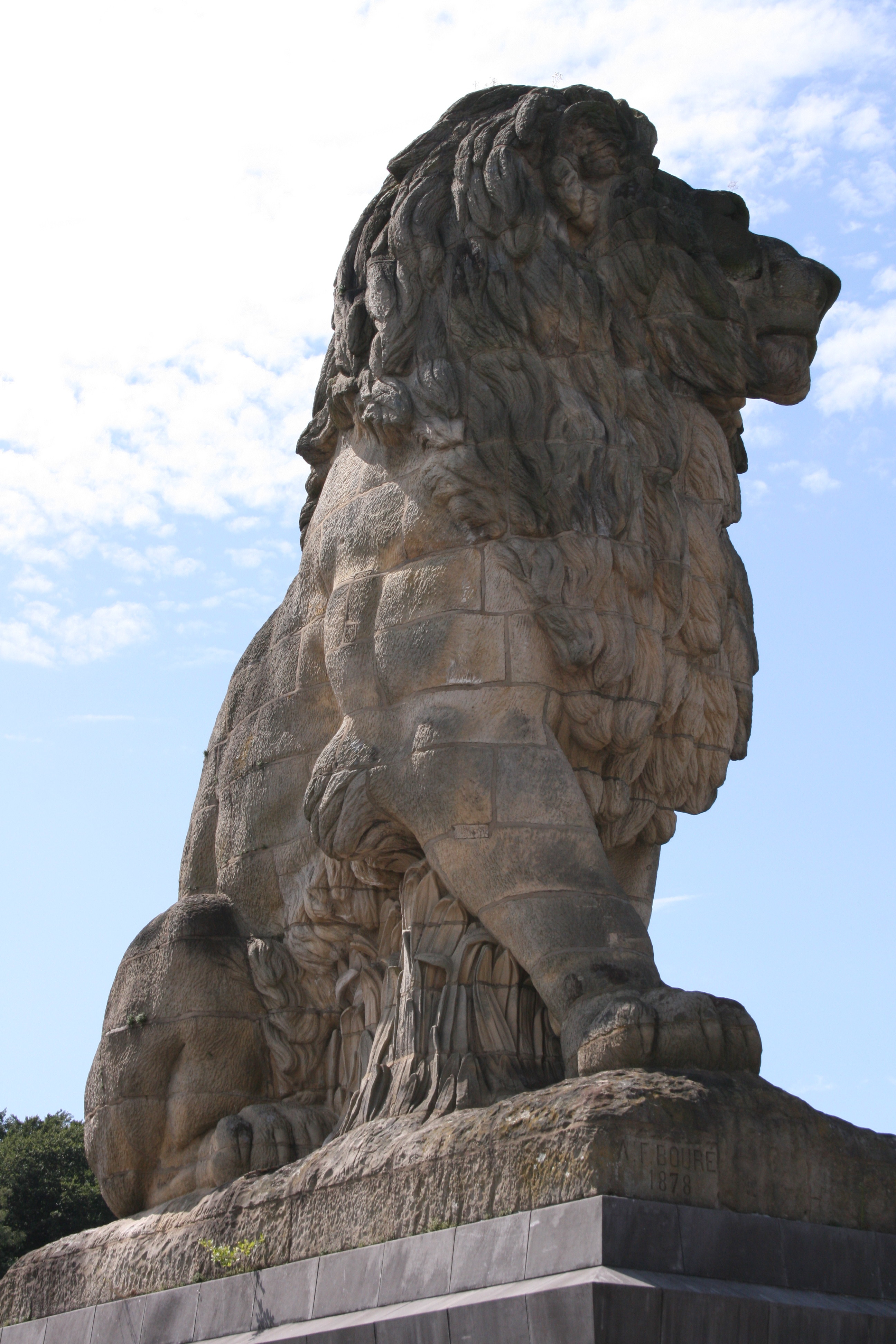
The Gileppe Dam (French ''Barrage de la Gileppe'') is an arch-gravity dam on the Gileppe river in Jalhay, Liège province, Wallonia, Belgium. It was built in the 1870s to supply water for the wool industry in nearby Verviers. The monumental structure with its unusually thick profile played an important role in establishing an international standard for masonry gravity dams as a technology for major water supply systems. It was considered one of the strongest dams in Europe at the time, and it was the first dam built in modern Belgium. In the first decade of the 21st century, it was noted as supplying most of the drinking water for Verviers, as well as industrial water, and as producing hydroelectricity. Background In the 19th century, the dam was built to ensure the water supply for Verviers, the center of the wool industry in Belgium. Wool was imported through Antwerp and washed at Verviers, situated between the Ardennes and Belgium's Carboniferous region, before it was ship ... [...More Info...] [...Related Items...] OR: [Wikipedia] [Google] [Baidu] |
Hydroelectricity
Hydroelectricity, or hydroelectric power, is electricity generated from hydropower (water power). Hydropower supplies one sixth of the world's electricity, almost 4500 TWh in 2020, which is more than all other renewable sources combined and also more than nuclear power. Hydropower can provide large amounts of low-carbon electricity on demand, making it a key element for creating secure and clean electricity supply systems. A hydroelectric power station that has a dam and reservoir is a flexible source, since the amount of electricity produced can be increased or decreased in seconds or minutes in response to varying electricity demand. Once a hydroelectric complex is constructed, it produces no direct waste, and almost always emits considerably less greenhouse gas than fossil fuel-powered energy plants. [...More Info...] [...Related Items...] OR: [Wikipedia] [Google] [Baidu] |
Engineer
Engineers, as practitioners of engineering, are professionals who invent, design, analyze, build and test machines, complex systems, structures, gadgets and materials to fulfill functional objectives and requirements while considering the limitations imposed by practicality, regulation, safety and cost. "Science is knowledge based on our observed facts and tested truths arranged in an orderly system that can be validated and communicated to other people. Engineering is the creative application of scientific principles used to plan, build, direct, guide, manage, or work on systems to maintain and improve our daily lives." The word ''engineer'' (Latin ) is derived from the Latin words ("to contrive, devise") and ("cleverness"). The foundational qualifications of an engineer typically include a four-year bachelor's degree in an engineering discipline, or in some jurisdictions, a master's degree in an engineering discipline plus four to six years of peer-reviewed professional pr ... [...More Info...] [...Related Items...] OR: [Wikipedia] [Google] [Baidu] |
Spring (hydrosphere)
A spring is a point of exit at which groundwater from an aquifer flows out on top of Earth's crust ( pedosphere) and becomes surface water. It is a component of the hydrosphere. Springs have long been important for humans as a source of fresh water, especially in arid regions which have relatively little annual rainfall. Springs are driven out onto the surface by various natural forces, such as gravity and hydrostatic pressure. Their yield varies widely from a volumetric flow rate of nearly zero to more than for the biggest springs. Formation Springs are formed when groundwater flows onto the surface. This typically happens when the groundwater table reaches above the surface level. Springs may also be formed as a result of karst topography, aquifers, or volcanic activity. Springs also have been observed on the ocean floor, spewing hot water directly into the ocean. Springs formed as a result of karst topography create karst springs, in which ground water travels throu ... [...More Info...] [...Related Items...] OR: [Wikipedia] [Google] [Baidu] |
Gileppe Dam
The Gileppe Dam (French ''Barrage de la Gileppe'') is an arch-gravity dam on the Gileppe river in Jalhay, Liège province, Wallonia, Belgium. It was built in the 1870s to supply water for the wool industry in nearby Verviers. The monumental structure with its unusually thick profile played an important role in establishing an international standard for masonry gravity dams as a technology for major water supply systems. It was considered one of the strongest dams in Europe at the time, and it was the first dam built in modern Belgium. In the first decade of the 21st century, it was noted as supplying most of the drinking water for Verviers, as well as industrial water, and as producing hydroelectricity. Background In the 19th century, the dam was built to ensure the water supply for Verviers, the center of the wool industry in Belgium. Wool was imported through Antwerp and washed at Verviers, situated between the Ardennes and Belgium's Carboniferous region, before it was ship ... [...More Info...] [...Related Items...] OR: [Wikipedia] [Google] [Baidu] |
Malaria
Malaria is a mosquito-borne infectious disease that affects humans and other animals. Malaria causes symptoms that typically include fever, tiredness, vomiting, and headaches. In severe cases, it can cause jaundice, seizures, coma, or death. Symptoms usually begin ten to fifteen days after being bitten by an infected mosquito. If not properly treated, people may have recurrences of the disease months later. In those who have recently survived an infection, reinfection usually causes milder symptoms. This partial resistance disappears over months to years if the person has no continuing exposure to malaria. Malaria is caused by single-celled microorganisms of the ''Plasmodium'' group. It is spread exclusively through bites of infected ''Anopheles'' mosquitoes. The mosquito bite introduces the parasites from the mosquito's saliva into a person's blood. The parasites travel to the liver where they mature and reproduce. Five species of ''Plasmodium'' can infect and be spread by h ... [...More Info...] [...Related Items...] OR: [Wikipedia] [Google] [Baidu] |
Population Dynamics Of Fisheries
A fishery is an area with an associated fish or aquatic population which is harvested for its commercial or recreational value. Fisheries can be wild or farmed. Population dynamics describes the ways in which a given population grows and shrinks over time, as controlled by birth, death, and migration. It is the basis for understanding changing fishery patterns and issues such as habitat destruction, predation and optimal harvesting rates. The population dynamics of fisheries is used by fisheries scientists to determine sustainable yields. The basic accounting relation for population dynamics is the BIDE (Birth, Immigration, Death, Emigration) model, shown as: : ''N''1 = ''N''0 + ''B'' − ''D'' + ''I'' − ''E'' where ''N''1 is the number of individuals at time 1, ''N''0 is the number of individuals at time 0, ''B'' is the number of individuals born, ''D'' the number that died, ''I'' the number that immigrated, and ''E'' the number that emigrated between time 0 and tim ... [...More Info...] [...Related Items...] OR: [Wikipedia] [Google] [Baidu] |
Water Pollution
Water pollution (or aquatic pollution) is the contamination of water bodies, usually as a result of human activities, so that it negatively affects its uses. Water bodies include lakes, rivers, oceans, aquifers, reservoirs and groundwater. Water pollution results when contaminants are introduced into these water bodies. Water pollution can be attributed to one of four sources: sewage discharges, industrial activities, agricultural activities, and urban runoff including stormwater. It can be grouped into surface water pollution (either fresh water pollution or marine pollution) or groundwater pollution. For example, releasing inadequately treated wastewater into natural waters can lead to degradation of these aquatic ecosystems. Water pollution can also lead to water-borne diseases for people using polluted water for drinking, bathing, washing or irrigation. Water pollution reduces the ability of the body of water to provide the ecosystem services (such as drinking wat ... [...More Info...] [...Related Items...] OR: [Wikipedia] [Google] [Baidu] |
Vesdre
The Vesdre ( French, ) or Weser ( German, ) and Vesder (Dutch, ) is a river in Liège Province, eastern Belgium. A few kilometres of the upper reaches also flow through the German municipality Roetgen and form part of the Belgian–German border. The Vesdre's total length is approximately . It is a right tributary to the river Ourthe. Its source lies in the High Fens (, , ), close to the border with Germany near Monschau. It flows through an artificial lake ( Lake Eupen), and then through the towns of Eupen, Verviers, Pepinster and Chaudfontaine. The Vesdre flows into the Ourthe a few kilometres from Liège where the Ourthe in turn flows into the river Meuse The Meuse ( , , , ; wa, Moûze ) or Maas ( , ; li, Maos or ) is a major European river, rising in France and flowing through Belgium and the Netherlands before draining into the North Sea from the Rhine–Meuse–Scheldt delta. It has a t .... The water of the Vesdre has a high acidity (due to the Hautes Fagnes b ... [...More Info...] [...Related Items...] OR: [Wikipedia] [Google] [Baidu] |
PH Indicator
A pH indicator is a halochromic chemical compound added in small amounts to a solution so the pH (acidity or basicity) of the solution can be determined visually or spectroscopically by changes in absorption and/or emission properties. Hence, a pH indicator is a chemical detector for hydronium ions (H3O+) or hydrogen ions (H+) in the Arrhenius model. Normally, the indicator causes the color of the solution to change depending on the pH. Indicators can also show change in other physical properties; for example, olfactory indicators show change in their odor. The pH value of a neutral solution is 7.0 at 25°C ( standard laboratory conditions). Solutions with a pH value below 7.0 are considered acidic and solutions with pH value above 7.0 are basic. Since most naturally occurring organic compounds are weak electrolytes, such as carboxylic acids and amines, pH indicators find many applications in biology and analytical chemistry. Moreover, pH indicators form one of the three ma ... [...More Info...] [...Related Items...] OR: [Wikipedia] [Google] [Baidu] |
Carboniferous
The Carboniferous ( ) is a geologic period and system of the Paleozoic that spans 60 million years from the end of the Devonian Period million years ago ( Mya), to the beginning of the Permian Period, million years ago. The name ''Carboniferous'' means "coal-bearing", from the Latin '' carbō'' ("coal") and '' ferō'' ("bear, carry"), and refers to the many coal beds formed globally during that time. The first of the modern 'system' names, it was coined by geologists William Conybeare and William Phillips in 1822, based on a study of the British rock succession. The Carboniferous is often treated in North America as two geological periods, the earlier Mississippian and the later Pennsylvanian. Terrestrial animal life was well established by the Carboniferous Period. Tetrapods (four limbed vertebrates), which had originated from lobe-finned fish during the preceding Devonian, became pentadactylous in and diversified during the Carboniferous, including early amphibian lin ... [...More Info...] [...Related Items...] OR: [Wikipedia] [Google] [Baidu] |
Ardennes
The Ardennes (french: Ardenne ; nl, Ardennen ; german: Ardennen; wa, Årdene ; lb, Ardennen ), also known as the Ardennes Forest or Forest of Ardennes, is a region of extensive forests, rough terrain, rolling hills and ridges primarily in Belgium and Luxembourg, extending into Germany and France. Geologically, the range is a western extension of the Eifel; both were raised during the Givetian age of the Devonian (382.7 to 387.7 million years ago), as were several other named ranges of the same greater range. The Ardennes proper stretches well into Germany and France (lending its name to the Ardennes department and the former Champagne-Ardenne region) and geologically into the Eifel (the eastern extension of the Ardennes Forest into Bitburg-Prüm, Germany); most of it is in the southeast of Wallonia, the southern and more rural part of Belgium (away from the coastal plain but encompassing more than half of the country's total area). The eastern part of the Ardennes forms t ... [...More Info...] [...Related Items...] OR: [Wikipedia] [Google] [Baidu] |


