|
Gallipoli
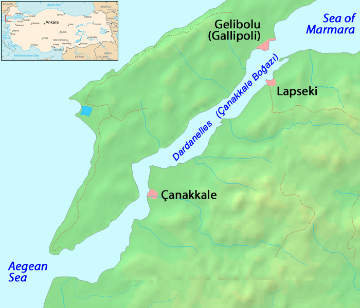
The Gallipoli Peninsula (; ; ) is located in the southern part of East Thrace, the European part of Turkey, with the Aegean Sea to the west and the Dardanelles strait to the east. Gallipoli is the Italian form of the Greek name (), meaning 'beautiful city', the original name of the modern town of Gelibolu. In antiquity, the peninsula was known as the Thracian Chersonese (; ). The peninsula runs in a south-westerly direction into the Aegean Sea, between the Dardanelles (formerly known as the Hellespont), and the Gulf of Saros (formerly the bay of Melas). In antiquity, it was protected by the Long Wall, a defensive structure built across the narrowest part of the peninsula near the ancient city of Agora. The isthmus traversed by the wall was only 36 stadia in breadthHerodotus, ''The Histories''vi. 36 Xenophon, ibid.; Pseudo-Scylax, '' Periplus of Pseudo-Scylax'', 67PDF) or about , but the length of the peninsula from this wall to its southern extremity, Cape Mastusia, was ... [...More Info...] [...Related Items...] OR: [Wikipedia] [Google] [Baidu] |
Dardanelles
The Dardanelles ( ; ; ), also known as the Strait of Gallipoli (after the Gallipoli peninsula) and in classical antiquity as the Hellespont ( ; ), is a narrow, natural strait and internationally significant waterway in northwestern Turkey that forms part of the continental boundary between Asia and Europe and separates Asian Turkey from European Turkey. Together with the Bosporus, the Dardanelles forms the Turkish Straits. One of the world's narrowest straits used for International waterway, international navigation, the Dardanelles connects the Sea of Marmara with the Aegean Sea, Aegean and Mediterranean Sea, Mediterranean seas while also allowing passage to the Black Sea by extension via the Bosporus. The Dardanelles is long and wide. It has an average depth of with a maximum depth of at its narrowest point abreast the city of Çanakkale. The first fixed crossing across the Dardanelles opened in 2022 with the completion of the 1915 Çanakkale Bridge. Most of the northe ... [...More Info...] [...Related Items...] OR: [Wikipedia] [Google] [Baidu] |
Hellespont
The Dardanelles ( ; ; ), also known as the Strait of Gallipoli (after the Gallipoli peninsula) and in classical antiquity as the Hellespont ( ; ), is a narrow, natural strait and internationally significant waterway in northwestern Turkey that forms part of the continental boundary between Asia and Europe and separates Asian Turkey from European Turkey. Together with the Bosporus, the Dardanelles forms the Turkish Straits. One of the world's narrowest straits used for international navigation, the Dardanelles connects the Sea of Marmara with the Aegean and Mediterranean seas while also allowing passage to the Black Sea by extension via the Bosporus. The Dardanelles is long and wide. It has an average depth of with a maximum depth of at its narrowest point abreast the city of Çanakkale. The first fixed crossing across the Dardanelles opened in 2022 with the completion of the 1915 Çanakkale Bridge. Most of the northern shores of the strait along the Gallipoli peni ... [...More Info...] [...Related Items...] OR: [Wikipedia] [Google] [Baidu] |
Gelibolu
Gelibolu is a town in Çanakkale Province of the Marmara Region, located in Eastern Thrace in the European part of Turkey. It is located on the southern shore of the Gallipoli, peninsula named after it on the Dardanelles strait, away from Lapseki on the other shore. It is the seat of Gelibolu District.İlçe Belediyesi Turkey Civil Administration Departments Inventory. Retrieved 1 March 2023. Its population is 31,782 (2021). History  The Macedonia (ancient kingdom), Macedonian city of Kallipolis was founded in the 5th century B.C. It has a rich history as a naval base ...
[...More Info...] [...Related Items...] OR: [Wikipedia] [Google] [Baidu] |
East Thrace
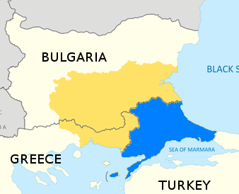
East Thrace or Eastern Thrace, also known as Turkish Thrace or European Turkey, is the part of Turkey that is geographically in Southeast Europe. Turkish Thrace accounts for 3.03% of Turkey's land area and 15% of its population. The largest city is Istanbul, which straddles the Bosporus between Europe and Asia. East Thrace is of historic importance as it is next to a major sea trade corridor and constitutes what remains of the once-vast Ottoman region of Rumelia. It is currently also of specific geostrategic importance because the sea corridor, which includes two narrow straits, provides access to the Mediterranean Sea from the Black Sea for the navies of five countries: Russia, Ukraine, Romania, Bulgaria, and Georgia (country), Georgia. The region also serves as a future connector of existing Turkish, Bulgarian, and Greek high-speed rail networks. Due to the guest worker agreement with Turkey and Germany, some Turks in Germany originally come from Eastern Thrace, mostly fr ... [...More Info...] [...Related Items...] OR: [Wikipedia] [Google] [Baidu] |
Turkey
Turkey, officially the Republic of Türkiye, is a country mainly located in Anatolia in West Asia, with a relatively small part called East Thrace in Southeast Europe. It borders the Black Sea to the north; Georgia (country), Georgia, Armenia, Azerbaijan, and Iran to the east; Iraq, Syria, and the Mediterranean Sea to the south; and the Aegean Sea, Greece, and Bulgaria to the west. Turkey is home to over 85 million people; most are ethnic Turkish people, Turks, while ethnic Kurds in Turkey, Kurds are the Minorities in Turkey, largest ethnic minority. Officially Secularism in Turkey, a secular state, Turkey has Islam in Turkey, a Muslim-majority population. Ankara is Turkey's capital and second-largest city. Istanbul is its largest city and economic center. Other major cities include İzmir, Bursa, and Antalya. First inhabited by modern humans during the Late Paleolithic, present-day Turkey was home to List of ancient peoples of Anatolia, various ancient peoples. The Hattians ... [...More Info...] [...Related Items...] OR: [Wikipedia] [Google] [Baidu] |
Elaeus
Elaeus ( ''Elaious'', later ''Elaeus''), the “Olive City”, was an ancient Greece, ancient Greek city located in Thrace, on the Thracian Chersonese. Elaeus was located at the southern end of the Hellespont (now the Dardanelles) near the southernmost point of the Thracian Chersonese (now the Gallipoli, Gallipoli peninsula) in modern-day Turkey. According to the geographer Scymnus, Elaeus was founded by settlers from Ionian Teos, while the Pseudo-Scymnus writes that it was a colony of Athens and was founded by Phorbas History The most important cities of the Chersonese were Lysimachia (Thrace), Lysimachia, Pactya, Gelibolu, Gallipoli, Alokopennesos, Sestos, Madytos (Colony), Madytos and Elaeus. The peninsula was renowned for its wheat. It also profited from its strategic location on the main trade route between Europe and Asia, as well as the possibility of controlling shipping to Crimea. For these reasons, Elaeus later received colonists from Athens, who built fortifica ... [...More Info...] [...Related Items...] OR: [Wikipedia] [Google] [Baidu] |
Gulf Of Saros
Gulf of Saros or Saros Bay () is a gulf north of the Dardanelles, Turkey. Ancient Greeks called it the Gulf of Melas (). The bay is long and wide. Far from industrialized areas and thanks to underwater currents, it is a popular summer recreation resort with sandy strands and crystal-clear sea. Scuba diving, windsurfing and fishing are the most practiced water sports here. Settlements around the bay are: Gökçetepe, Mecidiye, Erikli, Danişment, Yayla, Karaincirli, Vakıf, Büyükevren, Sultaniçe, Gülçavuş and Enez, all in Edirne Province. The islands of Gökçeada (Imbros) lie outside Saros Bay and Samothrace in the Aegean Sea, Greece, is in short distance. The North Anatolian Fault Zone, the most prominent active fault in Turkey and the source of numerous large earthquakes throughout history, passes through the Gulf of İzmit and traverses the Marmara Sea reaching to the Saros Bay to the southeast. In relative proximity, although outside of the gulf, on the Sout ... [...More Info...] [...Related Items...] OR: [Wikipedia] [Google] [Baidu] |
Long Wall (Thracian Chersonese)
The Long Wall () or Wall of Agora () after the nearby city, was a defensive wall at the base of the Thracian Chersonese (the modern peninsula of Gallipoli) in Antiquity. History The Long Wall was actually a succession of walls on the base of the Thracian Chersonese, the first of which was built in the late 6th century BC by the Athenian magnate Miltiades the Elder. Miltiades became the ruler of the Greek city-states of the Thracian Chersonese in 555 BC. Threatened by the warlike Apsinthians, the historian Herodotus (''The Histories''VI.36.2 reports that "his first act was to wall off the isthmus of the Chersonese from the city of Cardia across to Pactya, so that the Apsinthians would not be able to harm them by invading their land". Herodotus recorded the length of the isthmus as 36 stadia, or approximately 7.2 km. It is unknown how long the wall of Miltiades stood, but apparently it was left derelict soon after, for in the fifth century BC it had to be rebuilt by Pericles ... [...More Info...] [...Related Items...] OR: [Wikipedia] [Google] [Baidu] |
Sestos
Sestos (, ) was an ancient city in Thrace. It was located at the Thracian Chersonese peninsula on the European coast of the Hellespont, opposite the ancient city of Abydos, and near the town of Eceabat in Turkey. In Greek mythology, Sestos is presented in the myth of Hero and Leander as the home of Hero. History Classical period Sestos is first mentioned in Homer's ''Iliad'' as a Thracian settlement, and was allied with Troy during the Trojan War. The city was settled by colonists from Lesbos in c. 600 BC. In c. 512, Sestos was occupied by the Achaemenid Empire, and Darius I ferried across from the city to Asia Minor after his Scythian campaign. Alongside Byzantium, Sestos was considered to be one of the foremost Achaemenid ports on the European coast of the Bosphorus and the Hellespont. In 480, at the onset of the Second Persian invasion of Greece, Xerxes I bridged the Hellespont near Sestos. In 479 BC, after the Greek victory at the Battle of Mycale, Sestos was be ... [...More Info...] [...Related Items...] OR: [Wikipedia] [Google] [Baidu] |
Agora (Thrace)
Agora (), also called Cherronesos or Chersonesos (; IPA( key): /kʰer.ró.nɛː.sos/, /kʰer.só.nɛː.sos/), was an ancient Greek town in Thrace. It was situated about the middle of the narrow neck of the Thracian Chersonese (called today Gallipoli peninsula), and not far from Cardia, in what is now European Turkey. It was a colony of Athens, founded between 561 and 556 BCE, and a member of the Delian League. It is known for its series of tyrants in antiquity. Xerxes, when invading Greece in 480 BCE, passed through it. Its site is tentatively located near modern Bolayır, Turkey. Tyrants According to the Greek Historian Herodotus, Militiades the Elder was chosen by the Dolonci to be tyrant of Chersonesos. His most notable achievement was building a long wall to guard from invaders crossing the isthmus. Following the death of Militiades the Elder, his maternal half brother, Stesagoras acquired power. Stesagoras only ruled for approximately three years (519 - 516 BCE), w ... [...More Info...] [...Related Items...] OR: [Wikipedia] [Google] [Baidu] |

