|
Gallery Place (WMATA Station)
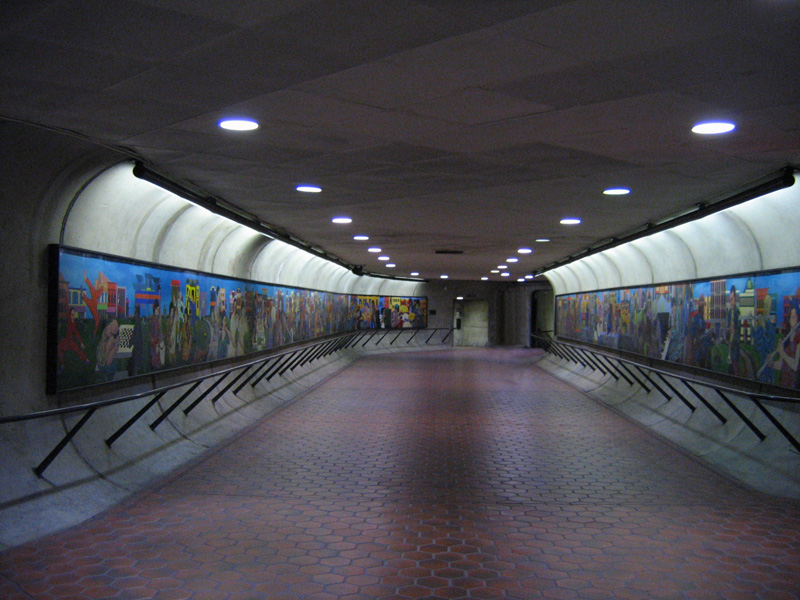
Gallery Place station is a Washington Metro station in Washington, D.C., United States, on the Green, Yellow and Red Lines. It is one of the 4 major transfer points, a transfer station between the Red Line on the upper level and the Green/Yellow Lines on the lower level. Gallery Place is located in Northwest Washington, with entrances at 7th and F, 7th and H, and 9th and G Streets. The station's only street elevator is north of F Street on the east side of 7th Street. The station, which is beneath Capital One Arena, serves that arena and the surrounding Chinatown and Penn Quarter neighborhoods in downtown Washington. Station layout Like other downtown transfer stations, Gallery Place has a two-level configuration. However, unlike Metro Center and L'Enfant Plaza, where the platforms cross centrally, the Green and Yellow Line platforms are located near the east end of the station, resulting in an off-balance layout. This is a result of the Green and Yellow Lines' locatio ... [...More Info...] [...Related Items...] OR: [Wikipedia] [Google] [Baidu] |
H Street (Washington, D
H Street or "H" Street is the eighth of a sequence of alphabetical streets in many cities. It may refer to: * H Street (Washington, D.C.) ** H Street/Benning Road Line, streetcar line in Washington, D.C. ** H Street Festival, yearly festival in Washington, D.C. ** H Street Playhouse, theatre and gallery in Washington, D.C. * H Street station, trolley car station in San Diego, California * H-Street, skateboarding company associated with Tony Magnusson {{disambiguation ... [...More Info...] [...Related Items...] OR: [Wikipedia] [Google] [Baidu] |
Tactile Paving
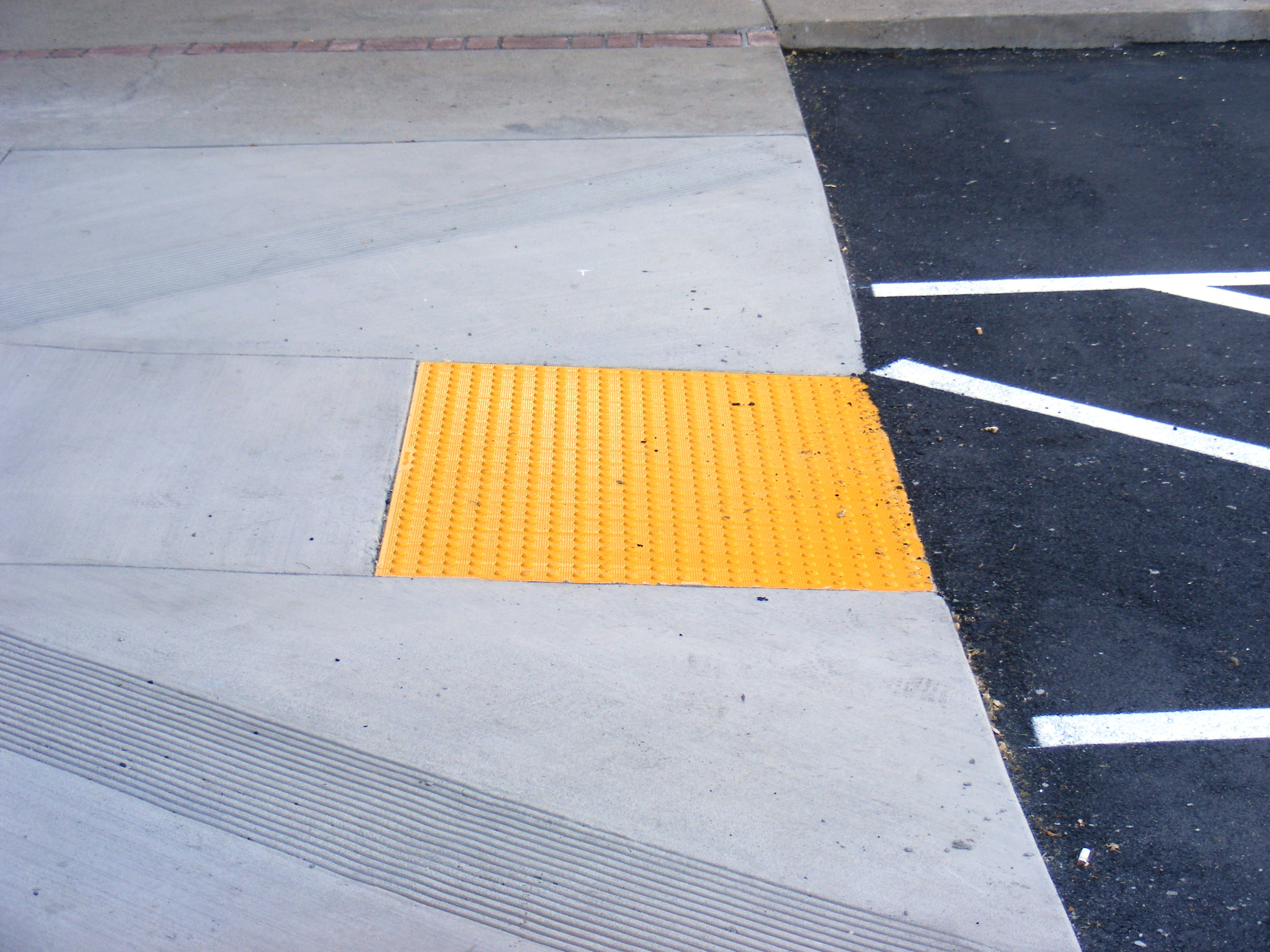
Tactile paving (also called tenji blocks, truncated domes, detectable warnings, tactile tiles, tactile ground surface indicators, tactile walking surface indicators, or detectable warning surfaces) is a system of textured ground surface indicators found at roadsides (such as at curb cuts), by and on stairs, and on railway station platforms, to assist pedestrians who are visually impaired. Tactile warnings provide a distinctive surface pattern of truncated domes, cones or bars, detectable by a long cane or underfoot, which are used to alert the vision-impaired of approaching streets and hazardous surface or grade changes. There is disagreement between the design and user community as to whether installing the aid inside buildings may cause a tripping hazard. A system of tactile paving was first instituted in Japan at pedestrian crossings and other hazardous road situations; the United Kingdom, Australia and the United States picked up the standard in the early 1990s. Canada ... [...More Info...] [...Related Items...] OR: [Wikipedia] [Google] [Baidu] |
Smithsonian American Art Museum
The Smithsonian American Art Museum (SAAM; formerly the National Museum of American Art) is a museum in Washington, D.C., part of the Smithsonian Institution. Together with its branch museum, the Renwick Gallery, SAAM holds one of the world's largest and most inclusive collections of art made in the United States from the colonial period to the present. More than 7,000 artists are represented in the museum's collection. Most exhibitions are held in the museum's main building, the Old Patent Office Building (which is shared with the National Portrait Gallery (United States), National Portrait Gallery), while craft-focused exhibitions are shown in the Renwick Gallery. The museum provides electronic resources to schools and the public through its national education program. It maintains seven online research databases with more than 500,000 records, including the Inventories of American Painting and Sculpture that document more than 400,000 artworks in public and private collection ... [...More Info...] [...Related Items...] OR: [Wikipedia] [Google] [Baidu] |
National Portrait Gallery, Washington, DC
The National Portrait Gallery (NPG) is an art museum in Washington, D.C., United States. Founded in 1962 and opened in 1968, it is part of the Smithsonian Institution. Its collections focus on images of American artists, politicians, scientists, inventors, activists, and performers who have contributed to the nation's history, development, and culture. Along with the Smithsonian American Art Museum, the museum is housed in the historic Old Patent Office Building. History Founding of the museum The first portrait gallery in the United States was Charles Willson Peale's ''American Pantheon'', also known as ''Peale's Collection of Portraits of American Patriots'', established in 1796. It closed after two years. In 1859, the National Portrait Gallery in London opened, but few Americans took notice.Thompson, Bob. "Who Gets Into the National Portrait Gallery, and Why?" ''Washington Post''. June 13, 1999. The idea of a federally owned national portrait gallery can be traced back to 1 ... [...More Info...] [...Related Items...] OR: [Wikipedia] [Google] [Baidu] |
Anacostia Station
Anacostia station is a Washington Metro station in Washington, D.C., on the Green Line. The station is located in the Anacostia neighborhood of Southeast Washington, with entrances at Shannon Place and Howard Road near Martin Luther King, Jr. Avenue SE (a major street serving the southeastern portion of the city). The station serves as a hub for Metrobus routes in Southeast, Washington, D.C., and Prince George's County, Maryland. Station layout The architecture at Anacostia is unusual. Due to cost considerations and the station's shallow depth, the usual arched ceiling was abandoned in favor of flat concrete walls and a ceiling of small barrel vaults (oriented perpendicular to the tracks) similar to the upper coffers in the six-coffer arch station design. The station is an underground stop because the distance between the Anacostia River tunnels and the station is too short to have permitted an above-ground stop. The station has entrances on both sides of DC-295/ I ... [...More Info...] [...Related Items...] OR: [Wikipedia] [Google] [Baidu] |
U Street Station
U Street station is a rapid transit station on the Green Line of the Washington Metro in the U Street neighborhood of Washington, D.C. U Street station is located in northwest Washington and serves the U Street neighborhood; nearby attractions include the Lincoln Theatre, the historic restaurant Ben's Chili Bowl, and several nightclubs, including The Black Cat and the 9:30 Club. The station is approximately five blocks east of the neighborhood of Adams Morgan. Station layout U Street station has a single island platform with entrances at either end, leading from U Street at 10th and 13th Streets. Like nearly all non-interchange stations on the Metro, there are two tracks: trains using track E1 head to Greenbelt, while those on E2 are bound for Branch Avenue. This station was among the last to feature the 22-coffer "waffle" ceiling vault design among , , , , and . History Plans for rapid transit prior to the creation of WMATA in February 1967 focused on the needs of c ... [...More Info...] [...Related Items...] OR: [Wikipedia] [Google] [Baidu] |
Ronald Reagan Washington National Airport (Washington Metro)
Ronald Reagan Washington National Airport station is a Washington Metro station in Arlington County, Virginia on the Blue and Yellow Lines. The station platform is elevated and covered and is the last above-ground station on the Yellow Line in Virginia, heading into Washington, D.C. The promise is one of only two stations in the system to have three tracks; the other is . The station is located across Smith Boulevard from Terminal 2 at Ronald Reagan Washington National Airport; the mezzanine is directly connected to Level 2 of the terminal (security checkpoints/gates level) by two pedestrian bridges. Airport shuttle buses or a walkway connect the station and Terminal 1. The airport's Abingdon Plantation historical site is near the station. History The station opened on July 1, 1977. Its opening coincided with the completion of of rail between National Airport and RFK Stadium and the opening of the , , , , , , , , , , , , , , , and stations. When service began on July 1 ... [...More Info...] [...Related Items...] OR: [Wikipedia] [Google] [Baidu] |
Pentagon (Washington Metro)
Pentagon station is a split platform station on the Washington Metro located adjacent to The Pentagon in Arlington, Virginia. The station was opened on July 1, 1977, and is operated by the Washington Metropolitan Area Transit Authority. Providing service for both the Blue and Yellow Lines, the station is where the two lines diverge and thus acts as a transfer point. Northbound, both lines rise above ground, with the Blue Line serving the station, and the Yellow Line crossing the Potomac River into the District of Columbia. The station opened on July 1, 1977 with the completion of of rail between National Airport and RFK Stadium. Photography is not allowed anywhere on the station grounds. Bus service Pentagon station is also a major bus hub in northern Virginia. The current bus facility opened in 2001 as part of the Pentagon Renovation Program. * Arlington Transit: 42, 87, 87A, 87P, 87X * DASH: 35, 103, 104 * Fairfax Connector: 306, 393, 394, 395, 396, 598, 599, 698, ... [...More Info...] [...Related Items...] OR: [Wikipedia] [Google] [Baidu] |
Rhode Island Avenue–Brentwood (Washington Metro)
Rhode Island Avenue station (also known as Rhode Island Avenue–Brentwood) is a Washington Metro station in Washington, D.C., on the Red Line. The station is located in the Brentwood neighborhood of Northeast, on an elevated platform crossing Rhode Island Avenue NE (U.S. Route 1) History The station was built on land formerly part of the African-American Columbian Harmony Cemetery. When the station was constructed in 1976, workers discovered that not all the bodies had been moved. At least five coffins were unearthed, and numerous bones. A plaque was affixed to a column near one of the station's entrances to commemorate the former cemetery. When a parking lot at the site was renovated in 1979, more bones and bits of cloth and coffins were unearthed. Service began on March 27, 1976, as one of the first stations in the system, opening as the eastern terminus of the Red Line. It was replaced as the eastern terminus by Silver Spring on February 6, 1978. From the time the st ... [...More Info...] [...Related Items...] OR: [Wikipedia] [Google] [Baidu] |
Farragut North (Washington Metro)
Farragut North station is an underground Washington Metro station in Washington, D.C., located on the Red Line. The station serves Downtown Washington and is immediately northwest of Farragut Square. With an average of 7,615 daily riders in 2023, Farragut North was the sixth-busiest stop in the system. History Farragut North was one of the original five stations to open with the first section of the Red Line on March 27, 1976. It was the western terminus of the Red Line until January 17, 1977, when Dupont Circle opened. In 1992, the station coffer was painted white. On February 12, 2010 at approximately 10:13 a.m. a train derailed in the pocket track immediately to the north of the station when the front car left the tracks. Of the approximately 345 passengers on board, one person was transported to the hospital. All of the passengers were evacuated without incident. The cause of the derailment was investigated by the National Transportation Safety Board. It was found th ... [...More Info...] [...Related Items...] OR: [Wikipedia] [Google] [Baidu] |


