|
Farah River
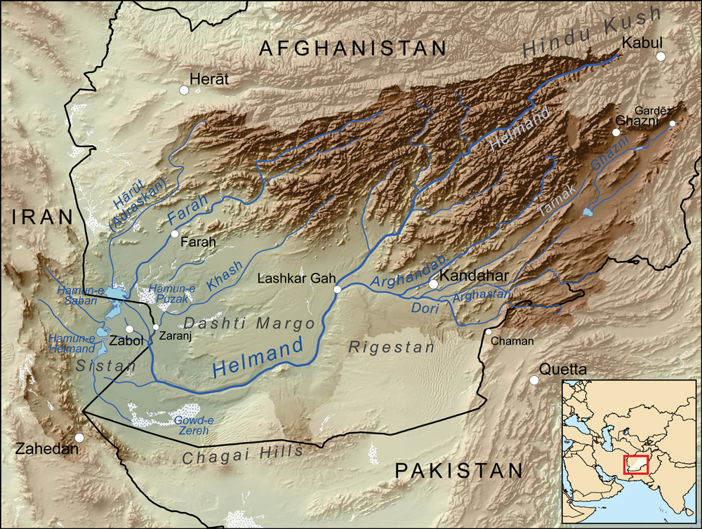
The Farah River ( ps, د فراه سیند; fa, فراه رود) is a river in western Afghanistan. The river originates in the Band-e Bayan Range in the eastern part of Ghor Province, and flows for to the Helmand swamps on the Afghanistan-Iran border. The city of Farah is located on the river, where in the dry season, it has a width of around and a depth of around . The lower valley of the Farah Rud is fertile and well cultivated. References External links Floods in Afghanistan (November 2006)at NASA Earth Observatory NASA Earth Observatory is an online publishing outlet for NASA which was created in 1999. It is the principal source of satellite imagery and other scientific information pertaining to the climate and the environment which are being provided by NA ... Rivers of Afghanistan Landforms of Farah Province {{Farah-geo-stub ... [...More Info...] [...Related Items...] OR: [Wikipedia] [Google] [Baidu] |
Afghanistan
Afghanistan, officially the Islamic Emirate of Afghanistan,; prs, امارت اسلامی افغانستان is a landlocked country located at the crossroads of Central Asia and South Asia. Referred to as the Heart of Asia, it is bordered by Pakistan to the east and south, Iran to the west, Turkmenistan to the northwest, Uzbekistan to the north, Tajikistan to the northeast, and China to the northeast and east. Occupying of land, the country is predominantly mountainous with plains in the north and the southwest, which are separated by the Hindu Kush mountain range. , its population is 40.2 million (officially estimated to be 32.9 million), composed mostly of ethnic Pashtuns, Tajiks, Hazaras, and Uzbeks. Kabul is the country's largest city and serves as its capital. Human habitation in Afghanistan dates back to the Middle Paleolithic era, and the country's strategic location along the historic Silk Road has led it to being described, picturesquely, as the ‘rounda ... [...More Info...] [...Related Items...] OR: [Wikipedia] [Google] [Baidu] |
Sistan Lake
Lake Hāmūn ( fa, دریاچه هامون, ''Daryācheh-ye Hāmūn''; ps, هامون ډنډ), or the Hamoun Oasis, is a seasonal lake and wetlands in the endorheic Sīstān Basin in the Sistan region on the Afghanistan–Iran border. In Iran, it is also known as ''Hāmūn-e Helmand'', ''Hāmūn-e Hīrmand'', or ''Daryācheh-ye Sīstān'' ("Lake Sīstān"). '' Hāmūn'' is a generic term which refers to shallow lakes (or lagoons), usually seasonal, that occur in the deserts of southeast Iran and adjacent areas of Afghanistan and Pakistan as a product of snowmelt in nearby mountains in spring. The term Hāmūn Lake (or Lake Hāmūn) is equally applied to ''Hāmūn-e Helmand'' (entirely in Iran), as well to the shallow lakes Hāmūn-e Sabari and Hāmūn-e Puzak, which extend into the territory of present-day Afghanistan with latter being almost entirely inside Afghanistan. The Hamun is fed by numerous seasonal water tributaries; the main tributary is the perennial Helmand River, ... [...More Info...] [...Related Items...] OR: [Wikipedia] [Google] [Baidu] |
Sistan Basin
The Sistan Basin is an inland endorheic basin encompassing large parts of southwestern Afghanistan and minor parts of southeastern Iran, one of the driest regions in the world and an area subjected to prolonged droughts. Its watershed is a system of rivers flowing from the highlands of Afghanistan into freshwater lakes and marshes and then to its ultimate destination: Afghanistan's saline Godzareh depression, part of the extensive Sistan terminal basin. The Helmand River drains the basin's largest watershed, fed mainly by snowmelt from the mountains of Hindu Kush, but other rivers contribute also. A basalt hill, known as Mount Khajeh, rises beside the lakes and marshes of the basin. Lakes The lowest part of the Sistan Basin contains a series of shallow lakes, known as '' hamuns''. It appears that in the past there was a single Hamun Lake, but there are now three separate lakes. From north to south the lakes are: Hamun-e Puzak The Hamun-e Puzak lies mostly in Afgha ... [...More Info...] [...Related Items...] OR: [Wikipedia] [Google] [Baidu] |
Helmand River
The Helmand River (also spelled Helmend, or Helmund, Hirmand; Pashto/ Persian: ; Greek: ' (''Etýmandros''); Latin: ') is the longest river in Afghanistan and the primary watershed for the endorheic Sistan Basin. It emerges in the Sanglakh Range of the Hindu Kush mountains in the northeastern part of Maidan Wardak Province, where it is separated from the watershed of the Kabul River by the Unai Pass. The Helmand feeds into the Hamun Lake on the border between Afghanistan and Iran. Etymology The name comes from the Avestan ''Haētumant'', literally "dammed, having a dam", which referred to the Helmand River and the irrigated areas around it. Geography The Helmand River stretches for . It rises in the northeastern part of Maidan Wardak Province in the Hindu Kush mountains, about 40 km west of Kabul (), flowing southwestward through Daykundi Province and Uruzgan Province. After passing through the city of Lashkargah in Helmand Province, it enters the desert o ... [...More Info...] [...Related Items...] OR: [Wikipedia] [Google] [Baidu] |
Harut River
The Harut River or Adraskan River is a river of Afghanistan. It is a river which belongs to the Sistan Basin. The source of the river lies in the mountains to the southeast of Herat Herāt (; Persian: ) is an oasis city and the third-largest city of Afghanistan. In 2020, it had an estimated population of 574,276, and serves as the capital of Herat Province, situated south of the Paropamisus Mountains (''Selseleh-ye Safē .... The river flows for about into the Sistan Lake. Along its course are various canals for irrigation, particularly in the plains of Sabzvar and Anardarah. The Khushkek River enters the Harut. References Rivers of Afghanistan Landforms of Herat Province {{Afghanistan-river-stub ... [...More Info...] [...Related Items...] OR: [Wikipedia] [Google] [Baidu] |
Ghor Province
Ghōr (Dari: ), also spelled Ghowr or Ghur, is one of the thirty-four provinces of Afghanistan. It is located in the western Hindu Kush in central Afghanistan, towards the northwest. The province contains eleven districts, encompassing hundreds of villages, and approximately 764,472 settled people. Firuzkoh (called Chaghcharan until 2014) serves as the capital of the province. Etymology The ancient Indo-European, Sogdian ''gor-''/''gur-'' ("mountain"-) is well preserved in all Slavic ''gor-''/''gór- (goor-/gur-)'', e.g.: Gorals, Goran, Goranci, Góra, Gora..., in Iranian languages, e.g.: Gorani language, Guran (Kurdish tribe)... and even in India and Nepal, e.g.: Gurkha. The Polish notation using ''gór-'' ("ó" stands for a sound between English "oo" and "u") instead of the popular ''gur-'' or ''ghur-'' preserves the ancient orthography. History The inhabitants of Ghor were completely Islamized during the Ghurids era. Before the 12th century, the area was hom ... [...More Info...] [...Related Items...] OR: [Wikipedia] [Google] [Baidu] |
Iran
Iran, officially the Islamic Republic of Iran, and also called Persia, is a country located in Western Asia. It is bordered by Iraq and Turkey to the west, by Azerbaijan and Armenia to the northwest, by the Caspian Sea and Turkmenistan to the north, by Afghanistan and Pakistan to the east, and by the Gulf of Oman and the Persian Gulf to the south. It covers an area of , making it the 17th-largest country. Iran has a population of 86 million, making it the 17th-most populous country in the world, and the second-largest in the Middle East. Its largest cities, in descending order, are the capital Tehran, Mashhad, Isfahan, Karaj, Shiraz, and Tabriz. The country is home to one of the world's oldest civilizations, beginning with the formation of the Elamite kingdoms in the fourth millennium BC. It was first unified by the Medes, an ancient Iranian people, in the seventh century BC, and reached its territorial height in the sixth century BC, when Cyrus the Great f ... [...More Info...] [...Related Items...] OR: [Wikipedia] [Google] [Baidu] |
Farah, Afghanistan
Farah (Pashto/Dari: ) is the capital and largest city of Farah Province in western Afghanistan. It is located on the Farah River, close to the border with Iran. It is one of the largest cities of western Afghanistan in terms of population, with about 1.5 million people living in its urban area. Land use Farah is located in western Afghanistan between Kandahar and Herat, close to the border with Iran, although it lacks a direct road connection with the latter. Farah has a very clear grid of roads distributed through the higher-density residential areas. However barren land (35%) and vacant plots (25%) are the largest land uses and combine for 60% of total land use. History Ancient history The Citadel at Farah is probably one of a series of fortresses constructed by Alexander the Great, the city being an intermediate stop between Alexandria Arachosia (modern Kandahar) and Herat, the location of another of Alexander's fortresses. The "Alexandria" prefix was added to th ... [...More Info...] [...Related Items...] OR: [Wikipedia] [Google] [Baidu] |
NASA Earth Observatory
NASA Earth Observatory is an online publishing outlet for NASA which was created in 1999. It is the principal source of satellite imagery and other scientific information pertaining to the climate and the environment which are being provided by NASA for consumption by the general public. It is funded with public money, as authorized by the United States Congress, and is part of the EOS Project Science Office located at Goddard Space Flight Center. , NASA Earth Observatory has won the Webby People's Voice Award in Education three times. There were a series of publicized images issued by the website in 2008, including imagery of clouds streaming over the Caspian Sea, dust storms curling off the coast of Morocco, the crumbling of the Wilkins Ice Shelf, Hurricane Bertha, and others. See also * Earth observation ** Earth observation satellite * Space exploration Space exploration is the use of astronomy and space technology to explore outer space. While the exploration o ... [...More Info...] [...Related Items...] OR: [Wikipedia] [Google] [Baidu] |
Rivers Of Afghanistan
A river is a natural flowing watercourse, usually freshwater, flowing towards an ocean, sea, lake or another river. In some cases, a river flows into the ground and becomes dry at the end of its course without reaching another body of water. Small rivers can be referred to using names such as creek, brook, rivulet, and rill. There are no official definitions for the generic term river as applied to geographic features, although in some countries or communities a stream is defined by its size. Many names for small rivers are specific to geographic location; examples are "run" in some parts of the United States, "burn" in Scotland and northeast England, and "beck" in northern England. Sometimes a river is defined as being larger than a creek, but not always: the language is vague. Rivers are part of the water cycle. Water generally collects in a river from precipitation through a drainage basin from surface runoff and other sources such as groundwater recharge, springs, ... [...More Info...] [...Related Items...] OR: [Wikipedia] [Google] [Baidu] |


