|
Fraser River (Western Australia)
The Fraser River is a river in the Kimberley region of Western Australia. The river rises northwest of Mount Jowlaenger and flows east passing through some permanent pools such as Ungalete Pool and Lowangun Pool before discharging into King Sound. The only tributary of the Fraser is Bungarragut Creek. The explorer Alexander Forrest visited the river in 1879. Forrest named the river after Malcolm Fraser, the Commissioner of Crown Lands at the time. The traditional owners of the areas around the river are the Nyikina The Nyikina people (also spelt Nyigina and Nyikena, and listed as Njikena by Tindale) are an Aboriginal Australian people of the Kimberley region of Western Australia. They come from the lower Fitzroy River (which they call ''mardoowarra''). .... References Rivers of the Kimberley region of Western Australia {{WesternAustralia-river-stub ... [...More Info...] [...Related Items...] OR: [Wikipedia] [Google] [Baidu] |
King Sound
King Sound is a large gulf in northern Western Australia. It expands from the mouth of the Fitzroy River (Western Australia), Fitzroy River, one of Australia's largest watercourses, and opens to the Indian Ocean. It is about long, and averages about in width. The port town of Derby, Western Australia, Derby lies near the mouth of the Fitzroy River on the eastern shore of King Sound. King Sound has the highest tides in Australia, and amongst the highest in the world, reaching a maximum tidal range of at Derby.Derby tides at derbytourism.com.au . Retrieved 7 January 2007 The tidal range and water dynamic were researched in 1997–1998. Waters within the sound are generally turbid. The turbidity is associated with the erosion of tidal flats. Geography Open waters of ...[...More Info...] [...Related Items...] OR: [Wikipedia] [Google] [Baidu] |
Sea Level
Mean sea level (MSL, often shortened to sea level) is an mean, average surface level of one or more among Earth's coastal Body of water, bodies of water from which heights such as elevation may be measured. The global MSL is a type of vertical datuma standardised geodetic datumthat is used, for example, as a chart datum in cartography and Navigation, marine navigation, or, in aviation, as the standard sea level at which atmospheric pressure is measured to Calibration, calibrate altitude and, consequently, aircraft flight levels. A common and relatively straightforward mean sea-level standard is instead a long-term average of tide gauge readings at a particular reference location. The term ''above sea level'' generally refers to the height above mean sea level (AMSL). The term APSL means above present sea level, comparing sea levels in the past with the level today. Earth's radius at sea level is 6,378.137 km (3,963.191 mi) at the equator. It is 6,356.752 km (3,94 ... [...More Info...] [...Related Items...] OR: [Wikipedia] [Google] [Baidu] |
CSIRO
The Commonwealth Scientific and Industrial Research Organisation (CSIRO) is an Australian Government agency that is responsible for scientific research and its commercial and industrial applications. CSIRO works with leading organisations around the world. From its headquarters in Canberra, CSIRO maintains more than 50 sites across Australia as well as in France and the United States, employing over 6,500 people. Federally funded scientific research in Australia began in 1916 with the creation of the Advisory Council of Science and Industry. However, the council struggled due to insufficient funding. In 1926, research efforts were revitalised with the establishment of the Council for Scientific and Industrial Research (CSIR), which strengthened national science leadership and increased research funding. CSIR grew rapidly, achieving significant early successes. In 1949, legislative changes led to the renaming of the organisation as Commonwealth Scientific and Industrial Research ... [...More Info...] [...Related Items...] OR: [Wikipedia] [Google] [Baidu] |
Kimberley (Western Australia)
The Kimberley is the northernmost of the nine regions of Western Australia. It is bordered on the west by the Indian Ocean, on the north by the Timor Sea, on the south by the Great Sandy Desert, Great Sandy and Tanami Desert, Tanami deserts in the region of the Pilbara, and on the east by the Northern Territory. The region was named in 1879 by government surveyor Alexander Forrest after Secretary of State for the Colonies John Wodehouse, 1st Earl of Kimberley. History The Kimberley was one of the earliest settled parts of Australia, with the first humans landing about 65,000 years ago. They created a complex culture that developed over thousands of years. Yam (vegetable), Yam (''Dioscorea hastifolia'') agriculture was developed, and rock art suggests that this was where some of the earliest boomerangs were invented. The worship of Wandjina deities was most common in this region, and a complex theology dealing with the transmigration of souls was part of the local people's religi ... [...More Info...] [...Related Items...] OR: [Wikipedia] [Google] [Baidu] |
Western Australia
Western Australia (WA) is the westernmost state of Australia. It is bounded by the Indian Ocean to the north and west, the Southern Ocean to the south, the Northern Territory to the north-east, and South Australia to the south-east. Western Australia is Australia's largest state, with a land area of , and is also the List of country subdivisions by area, second-largest subdivision of any country on Earth. Western Australia has a diverse range of climates, including tropical conditions in the Kimberley (Western Australia), Kimberley, deserts in the interior (including the Great Sandy Desert, Little Sandy Desert, Gibson Desert, and Great Victoria Desert) and a Mediterranean climate on the south-west and southern coastal areas. the state has 2.965 million inhabitants—10.9 percent of the national total. Over 90 percent of the state's population live in the South-West Land Division, south-west corner and around 80 percent live in the state capital Perth, leaving the remainder ... [...More Info...] [...Related Items...] OR: [Wikipedia] [Google] [Baidu] |
Tributary
A tributary, or an ''affluent'', is a stream or river that flows into a larger stream (''main stem'' or ''"parent"''), river, or a lake. A tributary does not flow directly into a sea or ocean. Tributaries, and the main stem river into which they flow, drain the surrounding drainage basin of its surface water and groundwater, leading the water out into an ocean, another river, or into an endorheic basin. The Irtysh is a chief tributary of the Ob (river), Ob river and is also the longest tributary river in the world with a length of . The Madeira River is the largest tributary river by volume in the world with an average discharge of . A confluence, where two or more bodies of water meet, usually refers to the joining of tributaries. The opposite to a tributary is a distributary, a river or stream that branches off from and flows away from the main stream. [...More Info...] [...Related Items...] OR: [Wikipedia] [Google] [Baidu] |
Alexander Forrest
Alexander Forrest CMG (22 September 1849 – 20 June 1901) was an explorer and surveyor of Western Australia, and later also a member of parliament. As a government surveyor, Forrest explored many areas of remote Western Australia, particularly the Kimberley region. Several of his expeditions were conducted alongside his brother, John Forrest, who became the first Premier of Western Australia. In later life, Forrest served in the unicameral Legislative Council from 1887 to 1890, representing the seat of Kimberley. Following the advent of responsible government, he was elected to the Legislative Assembly, representing the seat of West Kimberley from 1890 until his death. He was also mayor of Perth on two occasions, from 1892 to 1895 and from 1897 to 1900. Early life Forrest was born at Picton, near Bunbury in Western Australia, the fourth of nine sons of William and Margaret Forrest. He was educated at the government school in Bunbury under John Hislop, then completed hi ... [...More Info...] [...Related Items...] OR: [Wikipedia] [Google] [Baidu] |
Malcolm Fraser (surveyor)
Sir Malcolm Fraser (1834–17 August 1900) was Surveyor-General in colonial Western Australia from 1872 to 1883 and Agent-General for the colony 1892 to 1898. Malcolm Fraser was born in Gloucestershire, England in 1834. Nothing is known of his early life, except that he must have qualified as a surveyor at some stage, and that he emigrated to New Zealand. From 1857 to 1859, Fraser worked as a surveyor in Auckland. He was then district surveyor for the Native Land Purchase Department until 1863; district surveyor for the Canterbury West Gold Fields until 1867; and finally Chief Surveyor for Westland until 1869. In 1870, Fraser emigrated to Western Australia to take up the position of that colony's Surveyor-General, which had become vacant on the retirement of John Septimus Roe. Fraser was recruited to the position by then Governor of Western Australia Frederick Weld, who had formerly been Premier of New Zealand and knew Fraser personally from that time. Fraser commenced ... [...More Info...] [...Related Items...] OR: [Wikipedia] [Google] [Baidu] |
Commissioner Of Crown Lands (Western Australia)
Minister for Planning and Lands is a position in the government of Western Australia, currently held by John Carey of the Labor Party. The position was first created in 1870, under the name Commissioner of Crown Lands, at a time when Western Australia was still a British colony and had not yet achieved responsible government. Except for a brief period between 2001 and 2003, it has existed in every government since then. The minister is currently responsible for the state government's Land Use Management division comprising part of the Department of Planning, Lands and Heritage, which is responsible for the management of crown land in Western Australia. Titles * 18 December 1870 – 27 May 1901: Commissioner of Crown Lands * 27 May 1901 – 25 February 1983: Minister for Lands * 25 February 1983 – 25 February 1986: Minister for Lands and Surveys * 25 February 1986 – 16 February 2001: Minister for Lands * 27 June 2003 – 23 September 2008: Minister for Land Information * 23 ... [...More Info...] [...Related Items...] OR: [Wikipedia] [Google] [Baidu] |
Traditional Owners
Native title is the set of rights, recognised by Australian law, held by Aboriginal and Torres Strait Islander groups or individuals to land that derive from their maintenance of their traditional laws and customs. These Aboriginal title rights were first recognised as a part of Australian common law with the decision of '' Mabo v Queensland (No 2)'' in 1992. The doctrine was subsequently implemented and modified via statute with the '' Native Title Act 1993''. The concept recognises that in certain cases there was and is a continued beneficial legal interest in land held by Indigenous peoples which survived the acquisition of radical title and sovereignty to the land by the Crown. Native title can co-exist with non-Aboriginal proprietary rights and in some cases different Aboriginal groups can exercise their native title rights over the same land. The Federal Court of Australia arranges mediation in relation to claims made by Aboriginal and Torres Strait Islander peoples, ... [...More Info...] [...Related Items...] OR: [Wikipedia] [Google] [Baidu] |
Nyikina
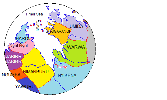
The Nyikina people (also spelt Nyigina and Nyikena, and listed as Njikena by Tindale) are an Aboriginal Australian people of the Kimberley region of Western Australia. They come from the lower Fitzroy River (which they call ''mardoowarra''). Language The Nyigina language is one of several eastern varieties of the Nyulnyulan languages, closely related to Warrwa and Yawuru. it was spoken by around 10 people. Country The Nyigina (Njikena) inhabited an area, estimated at . The area is located on the lower Fitzroy River from Yeeda upstream to Noonkanbah, on both banks. Education The Nyigina, together with the Mangala people, run the Nyikina Mangala Community School a school at Jarlmadangah in West Kimberley. The Nyigina-Mangala peoples also run another school, together with the Walmajarri, at Looma. Native title In 1998 the Nyigina people undertook legal proceedings to pursue their native title claims. One consisted of a ''Nyikina Mangala'' claim, which they shared w ... [...More Info...] [...Related Items...] OR: [Wikipedia] [Google] [Baidu] |


