|
Erzerum Province
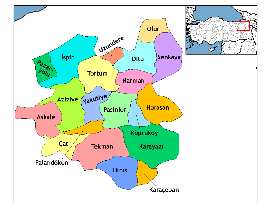
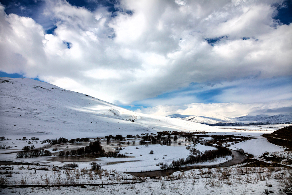
Erzurum Province ( tr, Erzurum ili) is a province of Turkey in the Eastern Anatolia Region of the country. The capital of the province is the city of Erzurum. It is bordered by the provinces of Kars and Ağrı to the east, Muş and Bingöl to the south, Erzincan and Bayburt to the west, Rize and Artvin to the north and Ardahan to the northeast. Okay Memiş was appointed as the governor of the province by a presidential decree on 27 October 2018. The province has an overall Turkish-majority. Geography The surface area of the province of Erzurum is the fourth biggest in Turkey. The majority of the province is elevated. Most plateaus are about above sea level, and the mountainous regions beyond the plateaus are and higher. Depression plains are located between the mountains and plateaus. The southern mountain ranges include the Palandöken Mountains (highest peak Büyük Ejder high) and the Şahveled Mountains (highest peak Çakmak Mountain high). The northern mountain ranges ... [...More Info...] [...Related Items...] OR: [Wikipedia] [Google] [Baidu] |
Provinces Of Turkey
Turkey is divided into 81 provinces ( tr, il). Each province is divided into a number of districts (). Each provincial government is seated in the central district (). For non- metropolitan municipality designated provinces, the central district bears the name of the province (e.g. the city/district of Rize is the central district of Rize Province). Each province is administered by an appointed governor () from the Ministry of the Interior. List of provinces Below is a list of the 81 provinces of Turkey, sorted according to their license plate codes. Initially, the order of the codes matched the alphabetical order of the province names. After Zonguldak (code 67), the ordering is not alphabetical, but in the order of the creation of provinces, as these provinces were created more recently and thus their plate numbers were assigned after the initial set of codes had been assigned. Codes The province's ISO code suffix number, the first two digits of the vehicle regi ... [...More Info...] [...Related Items...] OR: [Wikipedia] [Google] [Baidu] |
Rize Province
Rize Province ( tr, Rize ili) is a province of northeast Turkey, on the eastern Black Sea coast between Trabzon and Artvin. The province of Erzurum is to the south. It was formerly known as Lazistan, the designation of the term of Lazistan was officially banned in 1926, by patriots. The capital is the city of Rize. The province is home to Laz, Hemshin, Turkish people and Georgian communities. Etymology The name comes from Greek (riza), meaning "mountain slopes". The Georgian, Laz, and Armenian names are all derived from Greek as well: their names in respective order are ''Rize'' (რიზე), ''Rizini'' (რიზინი), and ''Rize'' (Ռիզե). History Ancient history We have little information as to the prehistory of this region, which being covered in thick forest is difficult to excavate and reveals little. Colchis which existed from the 13th to the 1st centuries BC is regarded as an early proto- Georgian polity in this area. Antiquity According to Pliny the ... [...More Info...] [...Related Items...] OR: [Wikipedia] [Google] [Baidu] |
Drainage Basin
A drainage basin is an area of land where all flowing surface water converges to a single point, such as a river mouth, or flows into another body of water, such as a lake or ocean. A basin is separated from adjacent basins by a perimeter, the '' drainage divide'', made up of a succession of elevated features, such as ridges and hills. A basin may consist of smaller basins that merge at river confluences, forming a hierarchical pattern. Other terms for a drainage basin are catchment area, catchment basin, drainage area, river basin, water basin, and impluvium. In North America, they are commonly called a watershed, though in other English-speaking places, "watershed" is used only in its original sense, that of a drainage divide. In a closed drainage basin, or endorheic basin, the water converges to a single point inside the basin, known as a sink, which may be a permanent lake, a dry lake, or a point where surface water is lost underground. Drainage basins are simi ... [...More Info...] [...Related Items...] OR: [Wikipedia] [Google] [Baidu] |
Scots Pine
''Pinus sylvestris'', the Scots pine (UK), Scotch pine (US) or Baltic pine, is a species of tree in the pine family Pinaceae that is native to Eurasia. It can readily be identified by its combination of fairly short, blue-green leaves and orange-red bark. Description ''Pinus sylvestris'' is an evergreen coniferous tree growing up to in height and in trunk diameter when mature, exceptionally over tall and in trunk diameter on very productive sites. The tallest on record is a tree over 210 years old tree growing in Estonia which stands at . The lifespan is normally 150–300 years, with the oldest recorded specimens in Lapland, Northern Finland over 760 years. The bark is thick, flaky and orange-red when young to scaly and gray-brown in maturity, sometimes retaining the former on the upper portion.Trees for LifeSpecies profile: Scots pine/ref> The habit of the mature tree is distinctive due to its long, bare and straight trunk topped by a rounded or flat-topped mass of ... [...More Info...] [...Related Items...] OR: [Wikipedia] [Google] [Baidu] |
Steppe
In physical geography, a steppe () is an ecoregion characterized by grassland plains without trees apart from those near rivers and lakes. Steppe biomes may include: * the montane grasslands and shrublands biome * the temperate grasslands, savannas and shrublands biome A steppe may be semi-arid or covered with grass or with shrubs or with both, depending on the season and latitude. The term " steppe climate" denotes the climate encountered in regions too dry to support a forest but not dry enough to be a desert. Steppe soils are typically of the chernozem type. Steppes are usually characterized by a semi-arid or continental climate. Extremes can be recorded in the summer of up to and in winter, . Besides this major seasonal difference, fluctuations between day and night are also very great. In both the highlands of Mongolia and northern Nevada, can be reached during the day with sub-freezing readings at night. Mid-latitude steppes feature hot summer ... [...More Info...] [...Related Items...] OR: [Wikipedia] [Google] [Baidu] |
Precipitation (meteorology)
In meteorology, precipitation is any product of the condensation of atmospheric water vapor that falls under gravitational pull from clouds. The main forms of precipitation include drizzle, rain, sleet, snow, ice pellets, graupel and hail. Precipitation occurs when a portion of the atmosphere becomes saturated with water vapor (reaching 100% relative humidity), so that the water condenses and "precipitates" or falls. Thus, fog and mist are not precipitation but colloids, because the water vapor does not condense sufficiently to precipitate. Two processes, possibly acting together, can lead to air becoming saturated: cooling the air or adding water vapor to the air. Precipitation forms as smaller droplets coalesce via collision with other rain drops or ice crystals within a cloud. Short, intense periods of rain in scattered locations are called showers. Moisture that is lifted or otherwise forced to rise over a layer of sub-freezing air at the surface may be conden ... [...More Info...] [...Related Items...] OR: [Wikipedia] [Google] [Baidu] |
Continental Climate
Continental climates often have a significant annual variation in temperature (warm summers and cold winters). They tend to occur in the middle latitudes (40 to 55 north), within large landmasses where prevailing winds blow overland bringing some precipitation, and temperatures are not moderated by oceans. Continental climates occur mostly in the Northern Hemisphere due to the large landmasses found there. Most of northern and northeastern China, eastern and southeastern Europe, Western and north western Iran, central and southeastern Canada, and the central and northeastern United States have this type of climate. Continentality is a measure of the degree to which a region experiences this type of climate. In continental climates, precipitation tends to be moderate in amount, concentrated mostly in the warmer months. Only a few areas—in the mountains of the Pacific Northwest of North America and in Iran, northern Iraq, adjacent Turkey, Afghanistan, Pakistan, and Central Asia� ... [...More Info...] [...Related Items...] OR: [Wikipedia] [Google] [Baidu] |
Allahüekber Dağları
Allahuekber Mountains ( tr, Allahuekber Dağları, which means "Allahu akbar Mountains"), is a mountain range in northeastern Turkey. The Kızılırmak River winds through it. It is part of the Pontic Mountains. When World War I began in 1914, the range was astride the border between the Ottoman Empire and the Russian Empire. Turkish troops suffered a disaster during the Battle of Sarikamish, when they were ordered to recapture the Kars area, which was then part of the Russian Empire. Thousands of Turkish soldiers died of hypothermia Hypothermia is defined as a body core temperature below in humans. Symptoms depend on the temperature. In mild hypothermia, there is shivering and mental confusion. In moderate hypothermia, shivering stops and confusion increases. In severe ... in the winter snow of the Allahuekber Mountains. In January 2022 a statue in memory of Turkish soldiers that froze to death in WWI was unveiled in Sarıkamış district. References {{EAnato ... [...More Info...] [...Related Items...] OR: [Wikipedia] [Google] [Baidu] |
Mountain Ranges
A mountain range or hill range is a series of mountains or hills arranged in a line and connected by high ground. A mountain system or mountain belt is a group of mountain ranges with similarity in form, structure, and alignment that have arisen from the same cause, usually an orogeny. Mountain ranges are formed by a variety of geological processes, but most of the significant ones on Earth are the result of plate tectonics. Mountain ranges are also found on many planetary mass objects in the Solar System and are likely a feature of most terrestrial planets. Mountain ranges are usually segmented by highlands or mountain passes and valleys. Individual mountains within the same mountain range do not necessarily have the same geologic structure or petrology. They may be a mix of different orogenic expressions and terranes, for example thrust sheets, uplifted blocks, fold mountains, and volcanic landforms resulting in a variety of rock types. Major ranges Most geologically ... [...More Info...] [...Related Items...] OR: [Wikipedia] [Google] [Baidu] |
Depression (geology)
In geology, a depression is a landform sunken or depressed below the surrounding area. Depressions form by various mechanisms. Types Erosion-related: * Blowout: a depression created by wind erosion typically in either a partially vegetated sand dune ecosystem or dry soils (such as a post-glacial loess environment). * Glacial valley: a depression carved by erosion by a glacier. * River valley: a depression carved by fluvial erosion by a river. * Area of subsidence caused by the collapse of an underlying structure, such as sinkholes in karst terrain. * Sink: an endorheic depression generally containing a persistent or intermittent (seasonal) lake, a salt flat (playa) or dry lake, or an ephemeral lake. * Panhole: a shallow depression or basin eroded into flat or gently sloping, cohesive rock.Twidale, C.R., and Bourne, J.A., 2018Rock basins (gnammas) revisited.''Géomorphologie: Relief, Processus, Environnement,'' Vol. 24, No. 2. January 2018. Retrieved 9 June 2020. Col ... [...More Info...] [...Related Items...] OR: [Wikipedia] [Google] [Baidu] |


