|
Equal-area Map Projection
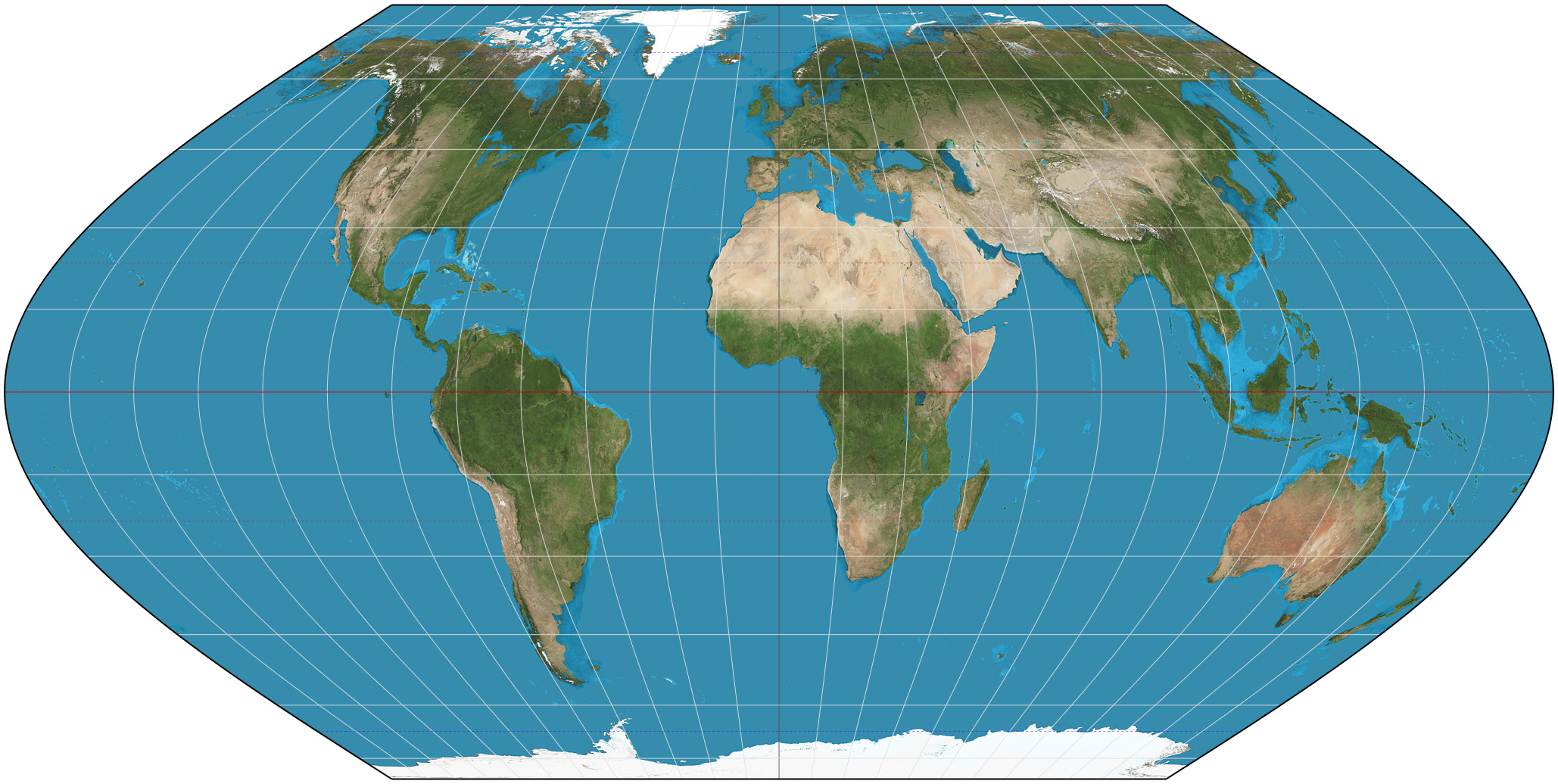
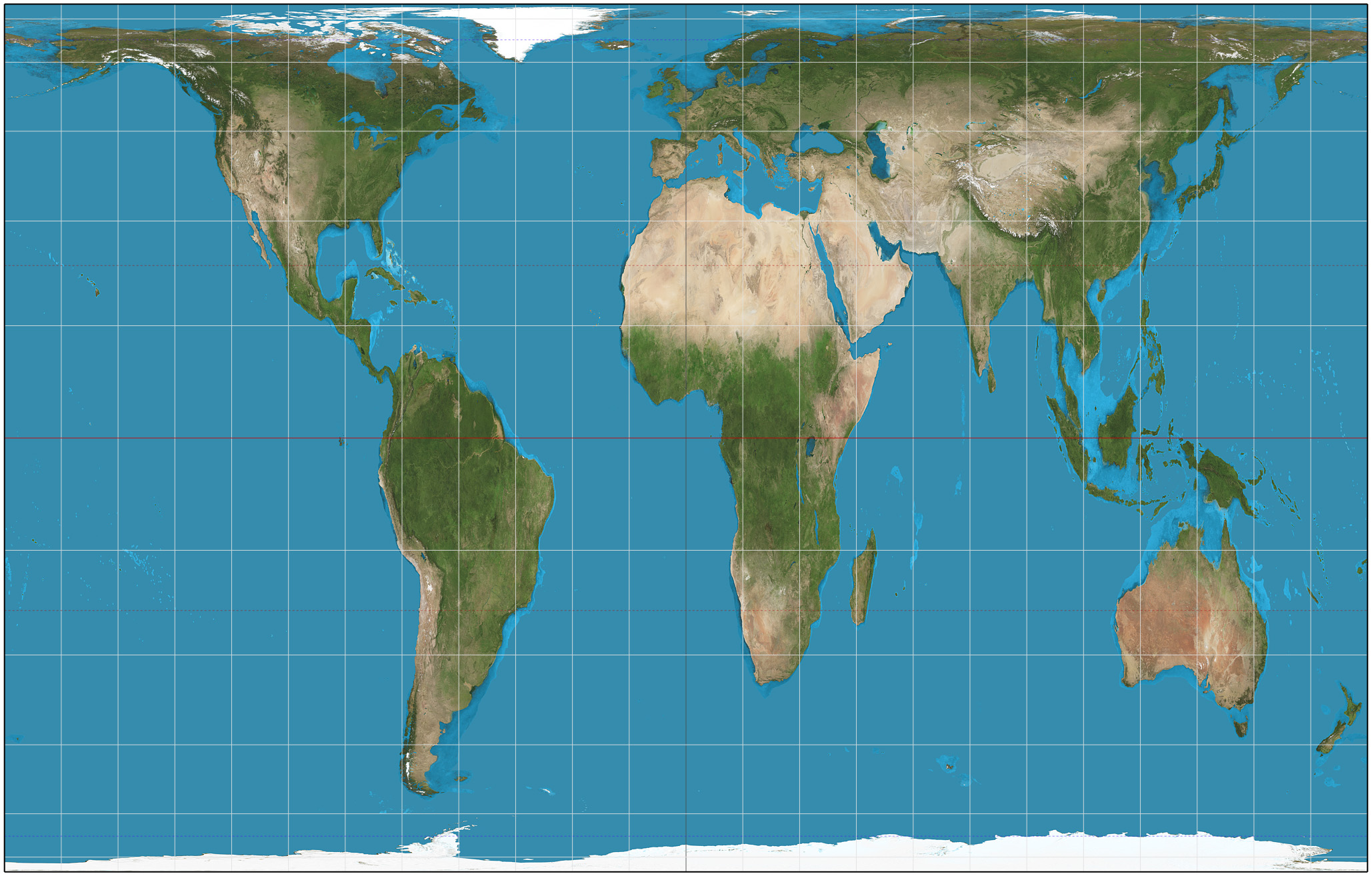
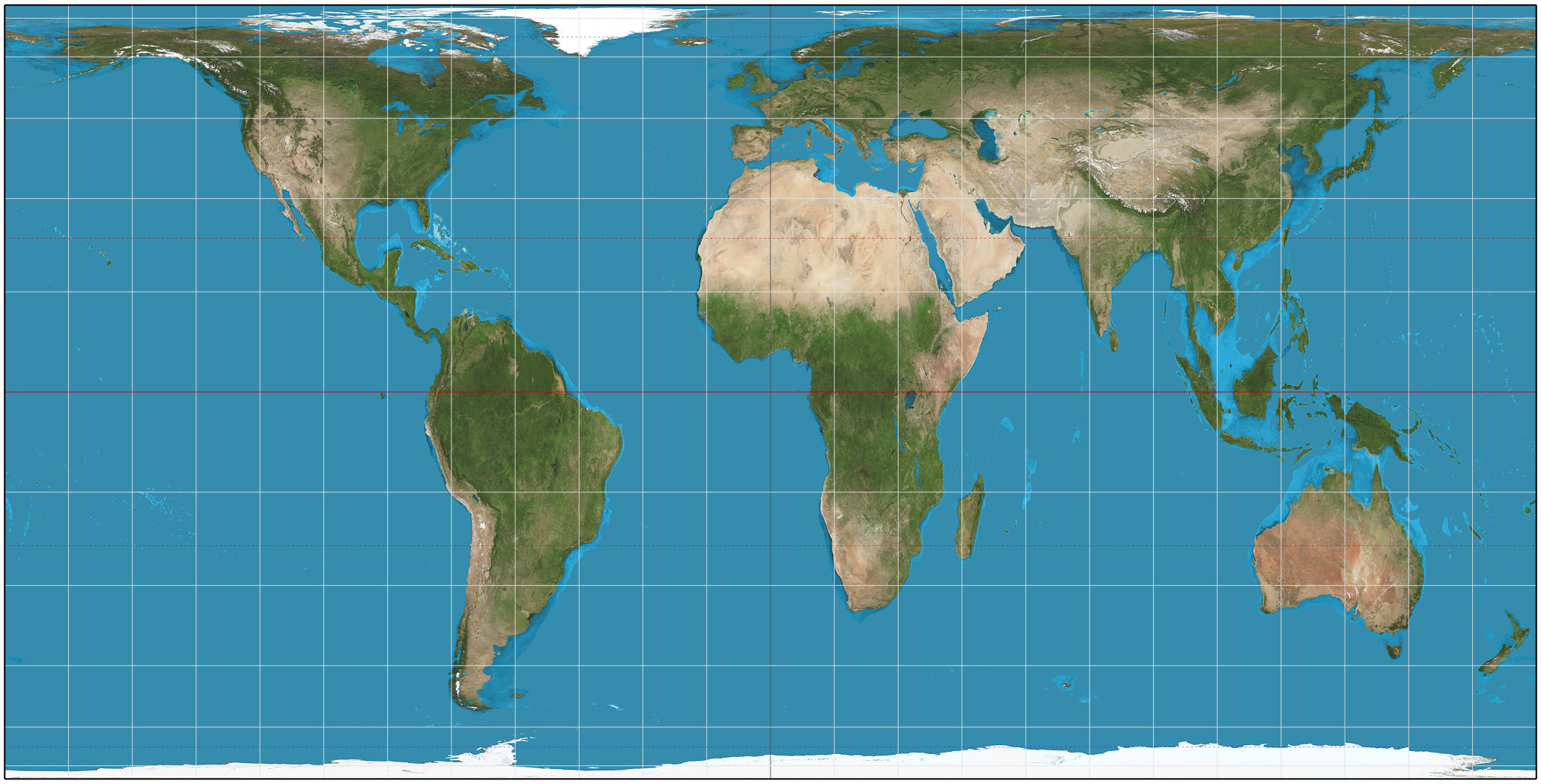
In cartography, an equal-area projection is a map projection that preserves area measure, generally distorting shapes in order to do that. Equal-area maps are also called equivalent or authalic. An equal-area map projection cannot be conformal, nor can a conformal map projection be equal-area. Several equivalent projections were developed in an attempt to minimize the distortion of countries and continents of planet Earth, keeping the area constant. Equivalent projections are widely used for thematic maps showing scenario distribution such as population, farmland distribution, forested areas, etc. Description Equal area representation implies that a region of interest in a particular portion of the map will share the same proportion of area as in any other part of the map. Statistical grid The term "statistical grid" refers to a discrete grid (global or local) of an equal-area surface representation, used for data visualization, geocode and statistical spatial analysis. ... [...More Info...] [...Related Items...] OR: [Wikipedia] [Google] [Baidu] |
Cartography
Cartography (; from grc, χάρτης , "papyrus, sheet of paper, map"; and , "write") is the study and practice of making and using maps. Combining science, aesthetics and technique, cartography builds on the premise that reality (or an imagined reality) can be modeled in ways that communicate spatial information effectively. The fundamental objectives of traditional cartography are to: * Set the map's agenda and select traits of the object to be mapped. This is the concern of map editing. Traits may be physical, such as roads or land masses, or may be abstract, such as toponyms or political boundaries. * Represent the terrain of the mapped object on flat media. This is the concern of map projections. * Eliminate characteristics of the mapped object that are not relevant to the map's purpose. This is the concern of generalization. * Reduce the complexity of the characteristics that will be mapped. This is also the concern of generalization. * Orchestrate the elements of t ... [...More Info...] [...Related Items...] OR: [Wikipedia] [Google] [Baidu] |
Bonne Projection
The Bonne projection is a pseudoconical equal-area map projection, sometimes called a dépôt de la guerre, modified Flamsteed, or a Sylvanus projection. Although named after Rigobert Bonne (1727–1795), the projection was in use prior to his birth, in 1511 by Sylvanus, Honter in 1561, De l'Isle before 1700 and Coronelli in 1696. Both Sylvanus and Honter's usages were approximate, however, and it is not clear they intended to be the same projection. The Bonne projection maintains accurate shapes of areas along the central meridian and the standard parallel, but progressively distorts away from those regions. Thus, it best maps "t"-shaped regions. It has been used extensively for maps of Europe and Asia. The projection is defined as: :\begin x &= \rho \sin E \\ y &= \cot \varphi_1 - \rho \cos E\end where :\begin\rho &= \cot \varphi_1 + \varphi_1 - \varphi \\ E &= \frac \end and ''φ'' is the latitude, ''λ'' is the longitude, ''λ''0 is the longitude of the central me ... [...More Info...] [...Related Items...] OR: [Wikipedia] [Google] [Baidu] |
Equal Earth Projection
The Equal Earth map projection is an equal-area pseudocylindrical projection for world maps, invented by Bojan Šavrič, Bernhard Jenny, and Tom Patterson in 2018. It is inspired by the widely used Robinson projection, but unlike the Robinson projection, retains the relative size of areas. The projection equations are simple to implement and fast to evaluate. The features of the Equal Earth projection include: * The curved sides of the projection suggest the spherical form of Earth. * Straight parallels make it easy to compare how far north or south places are from the equator. * Meridians are evenly spaced along any line of latitude. * Software for implementing the projection is easy to write and executes efficiently. According to the creators, the projection was created in response to the decision of the Boston public schools to adopt the Gall-Peters projection for world maps in March 2017, to accurately show the relative sizes of equatorial and non-equatorial regions. The de ... [...More Info...] [...Related Items...] OR: [Wikipedia] [Google] [Baidu] |
Eckert VI Projection
The Eckert VI projection is an equal-area pseudocylindrical map projection. The length of polar line is half that of the equator, and lines of longitude are sinusoids. It was first described by Max Eckert in 1906 as one of a series of three pairs of pseudocylindrical projections. In each pair, the meridians have the same shape, and the odd-numbered projection has equally spaced parallels, whereas the even-numbered projection has parallels spaced to preserve area. The pair to Eckert VI is the Eckert V projection. See also * List of map projections *Eckert II projection The Eckert II projection is an equal-area pseudocylindrical map projection. In the equatorial aspect (where the equator is shown as the horizontal axis) the network of longitude and latitude lines consists solely of straight lines, and the outer ... * Eckert IV projection References External links Eckert VI projection at Mathworld Map projections Equal-area projections {{Cartography-stub ... [...More Info...] [...Related Items...] OR: [Wikipedia] [Google] [Baidu] |
Eckert IV Projection
The Eckert IV projection is an equal-area pseudocylindrical map projection. The length of the polar lines is half that of the equator, and lines of longitude are semiellipses, or portions of ellipses. It was first described by Max Eckert in 1906 as one of a series of three pairs of pseudocylindrical projections. Within each pair, meridians are the same whereas parallels differ. Odd-numbered projections have parallels spaced equally, whereas even-numbered projections have parallels spaced to preserve area. Eckert IV is paired with Eckert III. Formulas Forward formulae Given a sphere of radius ''R'', central meridian ''λ'' and a point with geographical latitude ''φ'' and longitude ''λ'', plane coordinates ''x'' and ''y'' can be computed using the following formulas: : \begin x & = \frac R\, (\lambda - \lambda_0)(1 + \cos \theta) \approx 0.422\,2382\, R\, (\lambda - \lambda_0)(1 + \cos \theta), \\ pty & = 2 \sqrt R \sin \theta \approx 1.326\,5004\, R \sin \theta, \end where ... [...More Info...] [...Related Items...] OR: [Wikipedia] [Google] [Baidu] |
Eckert II Projection
The Eckert II projection is an equal-area pseudocylindrical map projection. In the equatorial aspect (where the equator is shown as the horizontal axis) the network of longitude and latitude lines consists solely of straight lines, and the outer boundary has the distinctive shape of an elongated hexagon. It was first described by Max Eckert in 1906 as one of a series of three pairs of pseudocylindrical projections. Within each pair, the meridians have the same shape, and the odd-numbered projection has equally spaced parallels, whereas the even-numbered projection has parallels spaced to preserve area. The pair to Eckert II is the Eckert I projection. Description The projection is symmetrical about the straight equator and straight central meridian. Parallels vary in spacing in order to preserve areas. As a pseudocylindric projection, spacing of meridians along any given parallel is constant. The poles are represented as lines, each half as long as the equator. The projection ... [...More Info...] [...Related Items...] OR: [Wikipedia] [Google] [Baidu] |
Collignon Projection
The Collignon projection is an equal-area pseudocylindrical map projection first known to be published by Édouard Collignon in 1865 and subsequently cited by A. Tissot in 1881. For the smallest choices of the parameters chosen for this projection, the sphere may be mapped either to a single diamond, a pair of squares, or a triangle. The projection is used in the polar areas as part of the HEALPix spherical projection, which is widely used in physical cosmology in making maps of the cosmic microwave background, in particular by the WMAP and Planck space missions. Formulae Let ''R'' be the radius of the sphere, ''φ'' the latitude, ''λ'' the longitude, and ''λ0'' the longitude of the central meridian (chosen as desired). Also, define s = \sqrt = \sqrt \sin\left(\frac - \frac\right), where the two forms are equivalent for ''φ'' in the range of possible latitudes. Then the Collignon projection is given by: :\begin x &= \fracR \left( \lambda - \lambda_0 \right) s, \\ y &= \ ... [...More Info...] [...Related Items...] OR: [Wikipedia] [Google] [Baidu] |
Boggs Eumorphic Projection
The Boggs eumorphic projection is a pseudocylindrical, equal-area map projection used for world maps. Normally it is presented with multiple interruptions. Its equal-area property makes it useful for presenting spatial distribution of phenomena. The projection was developed in 1929 by Samuel Whittemore Boggs (1889–1954) to provide an alternative to the Mercator projection for portraying global areal relationships. Boggs was geographer for the United States Department of State from 1924 until his death. The Boggs eumorphic projection has been used occasionally in textbooks and atlases. Boggs generally repeated regions in two different lobes of the interrupted map in order to show Greenland or eastern Russia undivided. He preferred his interrupted version, and named it "eumorphic”, meaning "goodly shaped" (in Boggs's own words). The projection's mathematical development was completed by Oscar S. Adams of the U.S. Coast and Geodetic Survey. Formulas The projection averages ... [...More Info...] [...Related Items...] OR: [Wikipedia] [Google] [Baidu] |
Gall–Peters Projection
The Gall–Peters projection is a rectangular, equal-area map projection. Like all equal-area projections, it distorts most shapes. It is a cylindrical equal-area projection with latitudes 45° north and south as the regions on the map that have no distortion. The projection is named after James Gall and Arno Peters. Gall described the projection in 1855 at a science convention and published a paper on it in 1885. Peters brought the projection to a wider audience beginning in the early 1970s through his "Peters World Map". The name "Gall–Peters projection" was first used by Arthur H. Robinson in a pamphlet put out by the American Cartographic Association in 1986.American Cartographic Association's Committee on Map Projections, 1986. ''Which Map is Best'' p. 12. Falls Church: American Congress on Surveying and Mapping. Maps based on the projection are promoted by UNESCO, and they are also widely used by British schools. The U.S. state of Massachusetts and Boston Public School ... [...More Info...] [...Related Items...] OR: [Wikipedia] [Google] [Baidu] |
Hobo–Dyer Projection
The Hobo–Dyer map projection is a normal cylindrical equal-area projection, with standard parallels (there is no north-south or east-west distortion) at 37.5° north and south of the equator. The map was commissioned in 2002 by Bob Abramms and Howard Bronstein of ODT Inc. and drafted by cartographer Mick Dyer, as a modification of the 1910 Behrmann projection. The name ''Hobo–Dyer'' is derived from Bronstein and Abramms's first names (Howard and Bob) and Dyer's surname. The original ODT map is printed on two sides, one side with north upwards and the other with south upwards. That, together with its equal-area presentation, is intended to present a different perspective compared with more common non-equal area, north-up maps. The goal is similar to that of other equal-area projections (such as the Gall–Peters projection), but the Hobo-Dyer is billed by the publisher as "more visually satisfying". To that end, the map stretches the low latitudes vertically less than Peter ... [...More Info...] [...Related Items...] OR: [Wikipedia] [Google] [Baidu] |
Behrmann Projection
The Behrmann projection is a cylindrical equal-area map projection described by Walter Behrmann in 1910. Cylindrical equal-area projections differ by their standard parallels, which are parallels along which the projection has no distortion. In the case of the Behrmann projection, the standard parallels are 30°N and 30°S. While equal-area, distortion of shape increases in the Behrmann projection according to distance from the standard parallels. The Behrmann projection has the property that half of the Earth's surface is stretched horizontally and the other half is stretched vertically. This projection is not equidistant A point is said to be equidistant from a set of objects if the distances between that point and each object in the set are equal. In two-dimensional Euclidean geometry, the locus of points equidistant from two given (different) points is th .... See also * List of map projections External links *Table of examples and properties of all common projecti ... [...More Info...] [...Related Items...] OR: [Wikipedia] [Google] [Baidu] |
Lambert Cylindrical Equal-area Projection
In cartography, the Lambert cylindrical equal-area projection, or Lambert cylindrical projection, is a cylindrical equal-area projection. This projection is undistorted along the equator, which is its standard parallel, but distortion increases rapidly towards the poles. Like any cylindrical projection, it stretches parallels increasingly away from the equator. The poles accrue infinite distortion, becoming lines instead of points. History The projection was invented by the Swiss mathematician Johann Heinrich Lambert and described in his 1772 treatise, ''Beiträge zum Gebrauche der Mathematik und deren Anwendung'', part III, section 6: ''Anmerkungen und Zusätze zur Entwerfung der Land- und Himmelscharten'', translated as, ''Notes and Comments on the Composition of Terrestrial and Celestial Maps''. Lambert's projection is the basis for the cylindrical equal-area projection family. Lambert chose the equator as the parallel of no distortion. By multiplying the projection's h ... [...More Info...] [...Related Items...] OR: [Wikipedia] [Google] [Baidu] |


