|
Dorotheenstadt
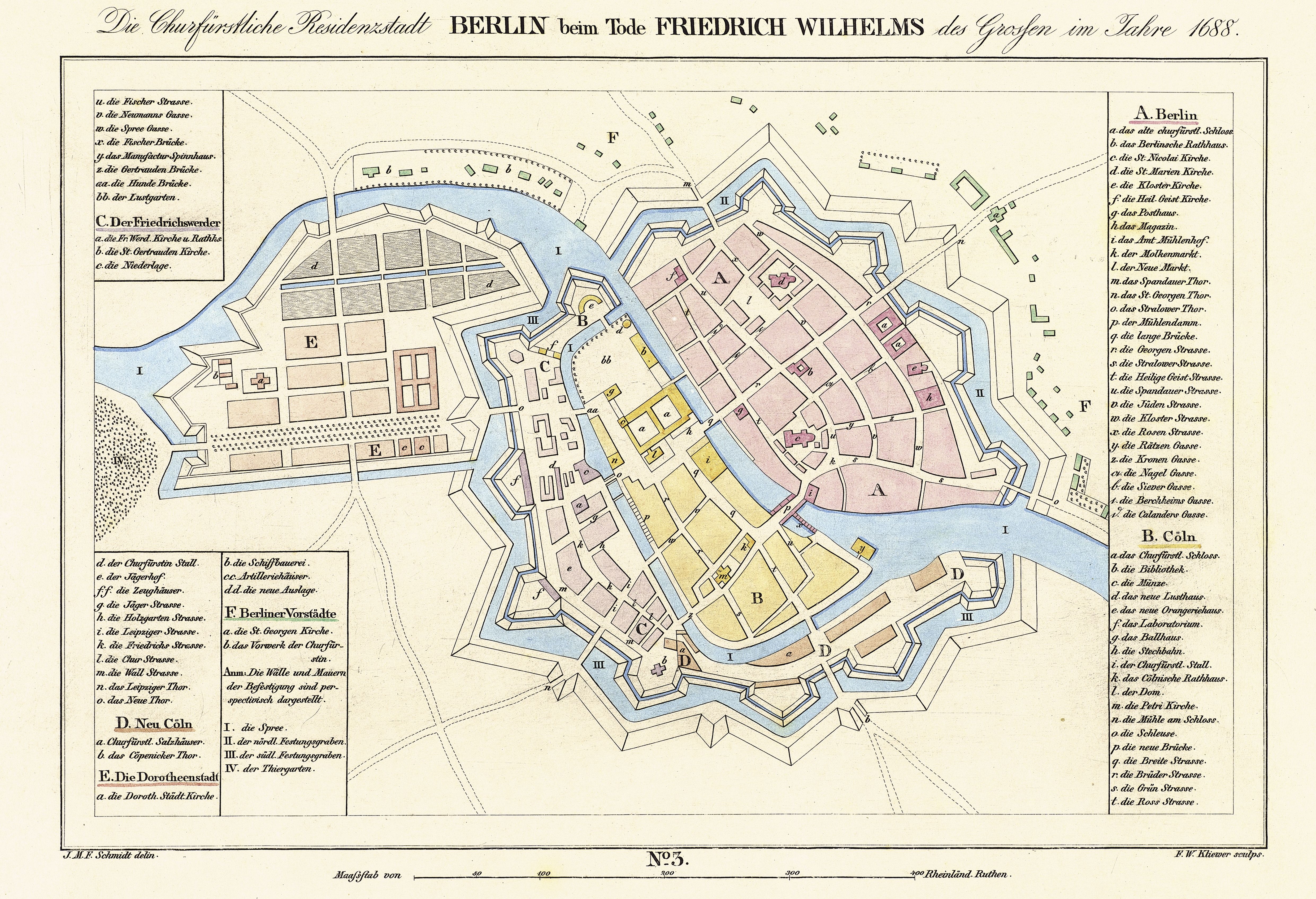
is a historic zone or neighbourhood (''Stadtviertel'') of central Berlin, Germany, which forms part of the locality (''Ortsteil'') of Mitte within the borough (''Bezirk'') also called Mitte. It contains several famous Berlin landmarks: the Brandenburg Gate, the Pariser Platz, and Unter den Linden. Location Dorotheenstadt is bordered in the west by the Großer Tiergarten, in the north by the River Spree, in the northeast by the Kupfergraben (part of the Spree canal system), in the east by Hinter dem Gießhaus and Oberwallstraße and in the south by the Behrenstraße. History In 1670, the "Great Elector" Frederick William made a gift to his second wife, Sophie Dorothea of Schleswig-Holstein-Sonderburg-Glücksburg, of the Cölln estate of Tiergarten, located between the wall surrounding Berlin and the Großer Tiergarten. A new settlement, initially called Neustadt (New Town), was laid out according to a strict rectangular street grid planned by Joachim Ernst Blesendorf, ... [...More Info...] [...Related Items...] OR: [Wikipedia] [Google] [Baidu] |
Friedrichstadt (Berlin)
Friedrichstadt was an independent suburb of Berlin, and is now a historical neighbourhood of the city itself. The neighbourhood is named after the Prussian king Frederick I. Geography Friedrichstadt is located south of the Dorotheenstadt neighbourhood, and southwest of the historical suburb of Friedrichswerder. It is located south of the twin-city zone of Berlin and Cölln. Today, the northern part of the neighbourhood is located in the borough of Berlin-Mitte, while the southern part of the neighbourhood is located in borough of Friedrichshain-Kreuzberg. The border between the two boroughs runs along the southern side of Niederkirchnerstraße and Zimmerstraße. The official boundaries of Friedrichstadt extend from the Spittelmarkt starting between northbound streets Niederwall- and Oberwallstraße, along Behrenstraße west to Ebertstraße, and then south over the Potsdamer Platz, Stresemann- and Gitschiner Straße, ending at the Hallesches Tor, and then again north over Li ... [...More Info...] [...Related Items...] OR: [Wikipedia] [Google] [Baidu] |
Berlin
Berlin ( , ) is the capital and largest city of Germany by both area and population. Its 3.7 million inhabitants make it the European Union's most populous city, according to population within city limits. One of Germany's sixteen constituent states, Berlin is surrounded by the State of Brandenburg and contiguous with Potsdam, Brandenburg's capital. Berlin's urban area, which has a population of around 4.5 million, is the second most populous urban area in Germany after the Ruhr. The Berlin-Brandenburg capital region has around 6.2 million inhabitants and is Germany's third-largest metropolitan region after the Rhine-Ruhr and Rhine-Main regions. Berlin straddles the banks of the Spree, which flows into the Havel (a tributary of the Elbe) in the western borough of Spandau. Among the city's main topographical features are the many lakes in the western and southeastern boroughs formed by the Spree, Havel and Dahme, the largest of which is Lake Müggelsee. Due to i ... [...More Info...] [...Related Items...] OR: [Wikipedia] [Google] [Baidu] |
Cölln
Cölln () was the twin city of Old Berlin ( Altberlin) from the 13th century to the 18th century. Cölln was located on the Fisher Island section of Spree Island, opposite Altberlin on the western bank of the River Spree, until the cities were merged by Frederick I of Prussia to form Berlin in 1710. Today, the former site of Cölln is the historic core of the modern Mitte locality of the Berlin-Mitte borough in central Berlin. History Cölln is first mentioned in a 1237 deed, denoting a priest Symeon of Cölln's (Symeon de Colonia) Saint Peter's Church as a witness. This date is commonly regarded as the origin of Berlin, though Altberlin on the eastern bank of the Spree river was not mentioned before 1244 and parts of modern Greater Berlin, such as Spandau and Köpenick, are even older. Cölln and Altberlin were separated only by the river Spree, linked by the ''Mühlendamm'' causeway, hence there was a close connection right from the start. Since the trade route from Magd ... [...More Info...] [...Related Items...] OR: [Wikipedia] [Google] [Baidu] |
Mitte (locality)
Mitte () (German for "middle" or "center") is a central locality () of Berlin in the eponymous district () of Mitte. Until 2001, it was itself an autonomous district. Mitte proper comprises the historic center of Alt-Berlin centered on the churches of St. Nicholas and St. Mary, the Museum Island, the city hall Rotes Rathaus, the city administrative building Altes Stadthaus, the Fernsehturm, Brandenburg Gate at the end of the central boulevard Unter den Linden and other tourist attractions. For these reasons, Mitte is considered the "heart" of Berlin. History Mitte comprises the historic center of Berlin ( and ). Its history thus corresponds to the history of the entire city until the early 20th century, and with the Greater Berlin Act in 1920 it became the first district of the city. It was among the areas of the city most heavily damaged in World War II. Following a territorial redeployment by the Soviet Union and the United Kingdom that reshaped the borders of West Be ... [...More Info...] [...Related Items...] OR: [Wikipedia] [Google] [Baidu] |
Friedrichswerder
Friedrichswerder is a neighborhood (''Stadtviertel''), situated in the Berliner locality (''Ortsteil'') of Mitte, part of the homonymous borough. It is identical to the town of Friedrichswerder, founded in 1662, which was an independent town until 1710. From 1710, Friedrichswerder belonged to the Prussian residence city of Berlin. The former town and the later district is named after Elector Friedrich Wilhelm. Geography Location Friedrichswerder lies between the Spreekanal and the moat, which was filled in between 1833 and 1883, the course of which can still be seen today on the property boundaries and which is characterized by the Moorish colonnades and the street on the moat. In the south the district borders on Neu-Kölln, in the west on Friedrichstadt. The Eiserne Bridge, the Schlossbrücke, the Schleusen Bridge and the Jungfern Bridge lead to the eastern part of the Cölln Cölln () was the twin city of Old Berlin ( Altberlin) from the 13th century to the 18t ... [...More Info...] [...Related Items...] OR: [Wikipedia] [Google] [Baidu] |
Friedrichstraße Station
The Friedrichstraße () (lit. ''Frederick Street'') is a major culture and shopping street in central Berlin, forming the core of the Friedrichstadt neighborhood and giving the name to Berlin Friedrichstraße station. It runs from the northern part of the old Mitte district (north of which it is called Chausseestraße) to the Hallesches Tor in the district of Kreuzberg. This downtown area is known for its expensive real estate market and the campus of the Hertie School of Governance. Due to its north-southerly direction, it forms important junctions with the east-western axes, most notably with Leipziger Straße and Unter den Linden. The U6 U-Bahn line runs underneath. During the Cold War it was bisected by the Berlin Wall and was the location of Checkpoint Charlie. Overview As central Berlin's traditional shopping street, Friedrichstraße is three blocks east of the parallel Wilhelmstraße, the historic heart of the old government quarter ''(Regierungsviertel)'' until 1945. ... [...More Info...] [...Related Items...] OR: [Wikipedia] [Google] [Baidu] |
Humboldt University
Humboldt-Universität zu Berlin (german: Humboldt-Universität zu Berlin, abbreviated HU Berlin) is a German public research university in the central borough of Mitte in Berlin. It was established by Frederick William III on the initiative of Wilhelm von Humboldt, Johann Gottlieb Fichte and Friedrich Ernst Daniel Schleiermacher as the University of Berlin () in 1809, and opened in 1810, making it the oldest of Berlin's four universities. From 1828 until its closure in 1945, it was named Friedrich Wilhelm University (german: Friedrich-Wilhelms-Universität). During the Cold War, the university found itself in East Berlin and was ''de facto'' split in two when the Free University of Berlin opened in West Berlin. The university received its current name in honour of Alexander and Wilhelm von Humboldt in 1949. The university is divided into nine faculties including its medical school shared with the Freie Universität Berlin. The university has a student enrollment of a ... [...More Info...] [...Related Items...] OR: [Wikipedia] [Google] [Baidu] |
Berlin State Library
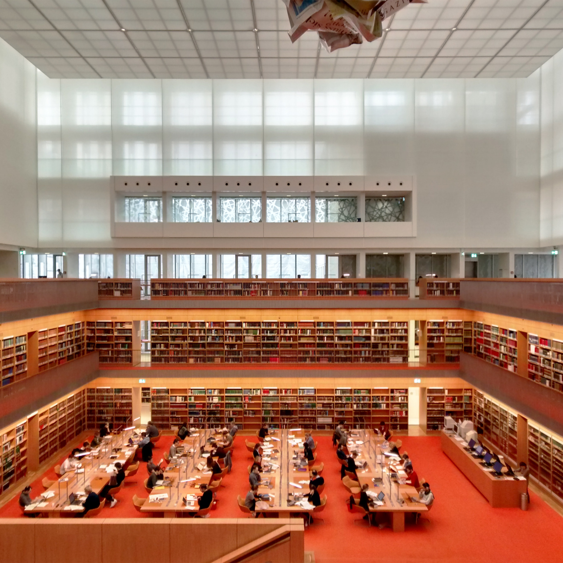
The Berlin State Library (german: Staatsbibliothek zu Berlin; officially abbreviated as ''SBB'', colloquially ''Stabi'') is a universal library in Berlin, Germany and a property of the Prussian Cultural Heritage Foundation. It is one of the largest libraries in Europe, and one of the most important academic research libraries in the German-speaking world. It collects texts, media and cultural works from all fields in all languages, from all time periods and all countries of the world, which are of interest for academic and research purposes. Some famous items in its collection include the oldest biblical illustrations in the fifth-century Quedlinburg Itala fragment, a Gutenberg Bible, the main autograph collection of Goethe, the world's largest collection of Johann Sebastian Bach's and Wolfgang Amadeus Mozart's manuscripts, and the original score of Ludwig van Beethoven's Symphony No. 9. Central functions and cooperation with other libraries The SBB is one of six librar ... [...More Info...] [...Related Items...] OR: [Wikipedia] [Google] [Baidu] |
Berlin Stadtbahn
The Berlin Stadtbahn ("city railway") is a major railway thoroughfare in the German capital Berlin, which runs through Berlin from east to west. It connects the eastern district of Friedrichshain with Charlottenburg in the west via 11 intermediate stations including Hauptbahnhof. The Berlin Stadtbahn is often also defined as the slightly longer route between Ostkreuz and Westkreuz, although this is not technically correct. The line was originally built in the 1880s. It is in length, and is entirely elevated above the city's streets. The four track route carries S-Bahn, Regionalbahn, Regional-Express, Intercity, EuroCity and Intercity-Express trains. Operation Structure and tracks The Stadtbahn line is an elevated rail line with viaducts totalling in length and including 731 masonry viaduct arches. A further of the line are situated on 64 bridges, that cross adjoining streets and (three times) the River Spree. The remaining length of the line is on an embankment. ... [...More Info...] [...Related Items...] OR: [Wikipedia] [Google] [Baidu] |
Greater Berlin
The Greater Berlin Act (german: Groß-Berlin-Gesetz), officially Law Regarding the Creation of the New Municipality of Berlin (german: Gesetz über die Bildung einer neuen Stadtgemeinde Berlin), was a law passed by the Prussian state government in 1920, which greatly expanded the size of the Prussian and German capital of Berlin. History Berlin had been part of the Province of Brandenburg since 1815. On 1 April 1881, the city became Stadtkreis Berlin, a city district separate from Brandenburg. The Greater Berlin Act was passed by the Prussian Parliament on 27 April 1920 and came into effect on 1 October of the same year. The new Prussian province then termed ''Greater Berlin'' acquired territories from the Province of Brandenburg and consisted of the following: * The city of Berlin (''Alt-Berlin''); * 7 towns that surrounded Berlin: Charlottenburg, Köpenick, Lichtenberg, Neukölln/Rixdorf, Schöneberg, Spandau and Wilmersdorf; * 59 rural communities and 27 estate districts f ... [...More Info...] [...Related Items...] OR: [Wikipedia] [Google] [Baidu] |
East Berlin
East Berlin was the ''de facto'' capital city of East Germany from 1949 to 1990. Formally, it was the Soviet sector of Berlin, established in 1945. The American, British, and French sectors were known as West Berlin. From 13 August 1961 until 9 November 1989, East Berlin was separated from West Berlin by the Berlin Wall. The Western Allied powers did not recognize East Berlin as the GDR's capital, nor the GDR's authority to govern East Berlin. On 3 October 1990, the day Germany was officially reunified, East and West Berlin formally reunited as the city of Berlin. Overview With the London Protocol of 1944 signed on 12 September 1944, the United States, the United Kingdom, and the Soviet Union decided to divide Germany into three occupation zones and to establish a special area of Berlin, which was occupied by the three Allied Forces together. In May 1945, the Soviet Union installed a city government for the whole city that was called "Magistrate of Greater Berlin", which ... [...More Info...] [...Related Items...] OR: [Wikipedia] [Google] [Baidu] |


