|
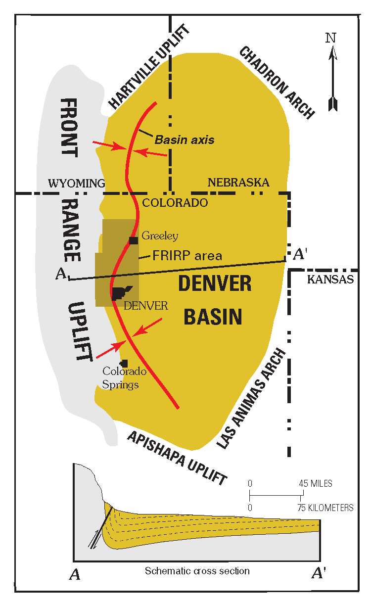
Denver Basin
The Denver Basin, variously referred to as the Julesburg Basin, Denver-Julesburg Basin (after Julesburg, Colorado), or the D-J Basin, is a geologic structural basin centered in eastern Colorado in the United States, but extending into southeast Wyoming, western Nebraska, and western Kansas. It underlies the Denver-Aurora Metropolitan Area on the eastern side of the Rocky Mountains. Geology The basin consists of a large asymmetric syncline of Paleozoic, Mesozoic, and Cenozoic sedimentary rock layers, trending north to south along the east side of the Front Range from the vicinity of Pueblo northward into Wyoming. The basin is deepest near Denver, where it reaches a depth of approximately 13,000 ft (3900 m) below the surface. The basin is strongly asymmetric: the Dakota Sandstone outcrops in a "hog-back" ridge near Morrison a few miles west of Denver, reaches its maximum depth beneath Denver, then ascends very gradually to its eastern outcrop in central Kansas. ... [...More Info...] [...Related Items...] OR: [Wikipedia] [Google] [Baidu] |
Denver Basin Location Map
Denver () is a consolidated city and county, the capital, and most populous city of the U.S. state of Colorado. Its population was 715,522 at the 2020 census, a 19.22% increase since 2010. It is the 19th-most populous city in the United States and the fifth most populous state capital. It is the principal city of the Denver–Aurora–Lakewood, CO Metropolitan Statistical Area and the first city of the Front Range Urban Corridor. Denver is located in the Western United States, in the South Platte River Valley on the western edge of the High Plains just east of the Front Range of the Rocky Mountains. Its downtown district is immediately east of the confluence of Cherry Creek and the South Platte River, approximately east of the foothills of the Rocky Mountains. It is named after James W. Denver, a governor of the Kansas Territory. It is nicknamed the ''Mile High City'' because its official elevation is exactly one mile () above sea level. The 105th meridian west of ... [...More Info...] [...Related Items...] OR: [Wikipedia] [Google] [Baidu] |
Front Range
The Front Range is a mountain range of the Southern Rocky Mountains of North America located in the central portion of the U.S. State of Colorado, and southeastern portion of the U.S. State of Wyoming. It is the first mountain range encountered as one goes westbound along the 40th parallel north across the Great Plains of North America. The Front Range runs north-south between Casper, Wyoming, and Pueblo, Colorado, and rises nearly 10,000 feet above the Great Plains. Longs Peak, Mount Evans, and Pikes Peak are its most prominent peaks, visible from the Interstate 25 corridor. The area is a popular destination for mountain biking, hiking, climbing, and camping during the warmer months and for skiing and snowboarding during winter. Millions of years ago, the present-day Front Range was home to ancient mountain ranges, deserts, beaches, and even oceans. The name "Front Range" is also applied to the Front Range Urban Corridor, the populated region of Colorado and Wyoming just eas ... [...More Info...] [...Related Items...] OR: [Wikipedia] [Google] [Baidu] |
Unconformity
An unconformity is a buried erosional or non-depositional surface separating two rock masses or strata of different ages, indicating that sediment deposition was not continuous. In general, the older layer was exposed to erosion for an interval of time before deposition of the younger layer, but the term is used to describe any break in the sedimentary geologic record. The significance of angular unconformity (see below) was shown by James Hutton, who found examples of Hutton's Unconformity at Jedburgh in 1787 and at Siccar Point in 1788. The rocks above an unconformity are younger than the rocks beneath (unless the sequence has been overturned). An unconformity represents time during which no sediments were preserved in a region or were subsequently eroded before the next deposition. The local record for that time interval is missing and geologists must use other clues to discover that part of the geologic history of that area. The interval of geologic time not represen ... [...More Info...] [...Related Items...] OR: [Wikipedia] [Google] [Baidu] |
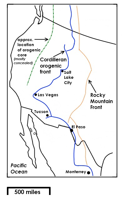
Rocky Mountain Front
The Rocky Mountain Front is a somewhat unified geologic and ecosystem area in North America where the eastern slopes of the Rocky Mountains meet the plains. In 1983, the Bureau of Land Management called the Rocky Mountain Front "a nationally significant area because of its high wildlife, recreation, and scenic values". Conservationists Gregory Neudecker, Alison Duvall, and James Stutzman have described the Rocky Mountain Front as an area that warrants "the highest of conservation priorities" because it is largely unaltered by development and contains "unparalleled" numbers of wildlife. Defining the Rocky Mountain Front Although the Rocky Mountain Front is clearly distinct from both plains and mountains, in places like the Wyoming Basin, Montana, and New Mexico it is more ambiguous. One definition of the front is that it is a "transition zone between the Rocky Mountains and the mixed grass prairie ... hatencompasses a wide variety of wetland, riparian, grassland, and forested habit ... [...More Info...] [...Related Items...] OR: [Wikipedia] [Google] [Baidu] |
Red Rocks Amphitheatre
Red Rocks Amphitheatre (also colloquially as simply Red Rocks) is an open-air amphitheatre built into a rock structure in the western United States, near Morrison, Colorado, west of Denver. There is a large, tilted, disc-shaped rock behind the stage, a huge vertical rock angled outwards from stage right, several large outcrops angled outwards from stage left and a seating area for up to 9,525. In 1927, the City of Denver purchased the area of Red Rocks; construction of the amphitheater began in 1936, and was opened to the public in June 1941.Red Rocks Park Timeline of the 1930s and 1940s, from Denvergov.org Since then, many notable performances and recordings for film and television have taken place there. In June 2015, the [...More Info...] [...Related Items...] OR: [Wikipedia] [Google] [Baidu] |
Red Rocks Park
Red Rocks Park is a mountain park in Jefferson County, Colorado, owned and maintained by the city of Denver as part of the Denver Mountain Parks system. The park is known for its very large red sandstone outcrops. Many of these rock formations within the park have names, from the mushroom-shaped Seat of Pluto to the inclined Cave of the Seven Ladders. The most visited rocks, around Red Rocks Amphitheatre, are Creation Rock to the north, Ship Rock to the south, and Stage Rock to the east. The red sandstone found throughout Red Rocks Park is geologically identified as belonging to the Fountain Formation. Other Colorado examples of Fountain Formation geology include nearby Roxborough State Park, Garden of the Gods near Colorado Springs, and the Flatirons near Boulder. The rocks were formed about 290-296 million years ago when the Ancestral Rocky Mountains were eroded during the Pennsylvanian epoch. Later, uplift during the Laramide orogeny tilted the rocks to the angle at which the ... [...More Info...] [...Related Items...] OR: [Wikipedia] [Google] [Baidu] |
Flatiron (geomorphology)
Traditionally in geomorphology, a flatiron is a steeply sloping triangular landform created by the differential erosion of a steeply dipping, erosion-resistant layer of rock overlying softer strata. Flatirons have wide bases that form the base of a steep, triangular facet that narrows upward into a point at its summit. The dissection of a hogback by regularly spaced streams often results in the formation of a series of flatirons along the strike of the rock layer that formed the hogback.Ollier, C. D. (1985) ''Glossary of Morphotectonics,'' 2nd ed. Bureau of Mineral Resources. Geology and Geophysics Record no. 1985/30. Dept. of Geology and Geophysics, Canberra, Australia. 55 pp. Fairbridge, RW (1968) ''Hogback and Flatiron.'' In RW Fairbridge, ed., pp. 524-525, ''The Encyclopedia of Geomorphology'' (Encyclopedia of Earth Sciences, Volume III), Reinhold, New York, 1296 pp. Huggett, JL (2011) ''Fundamentals of Geomorphology.'' Routledge. New York, New York. 516 pp. As noted in s ... [...More Info...] [...Related Items...] OR: [Wikipedia] [Google] [Baidu] |
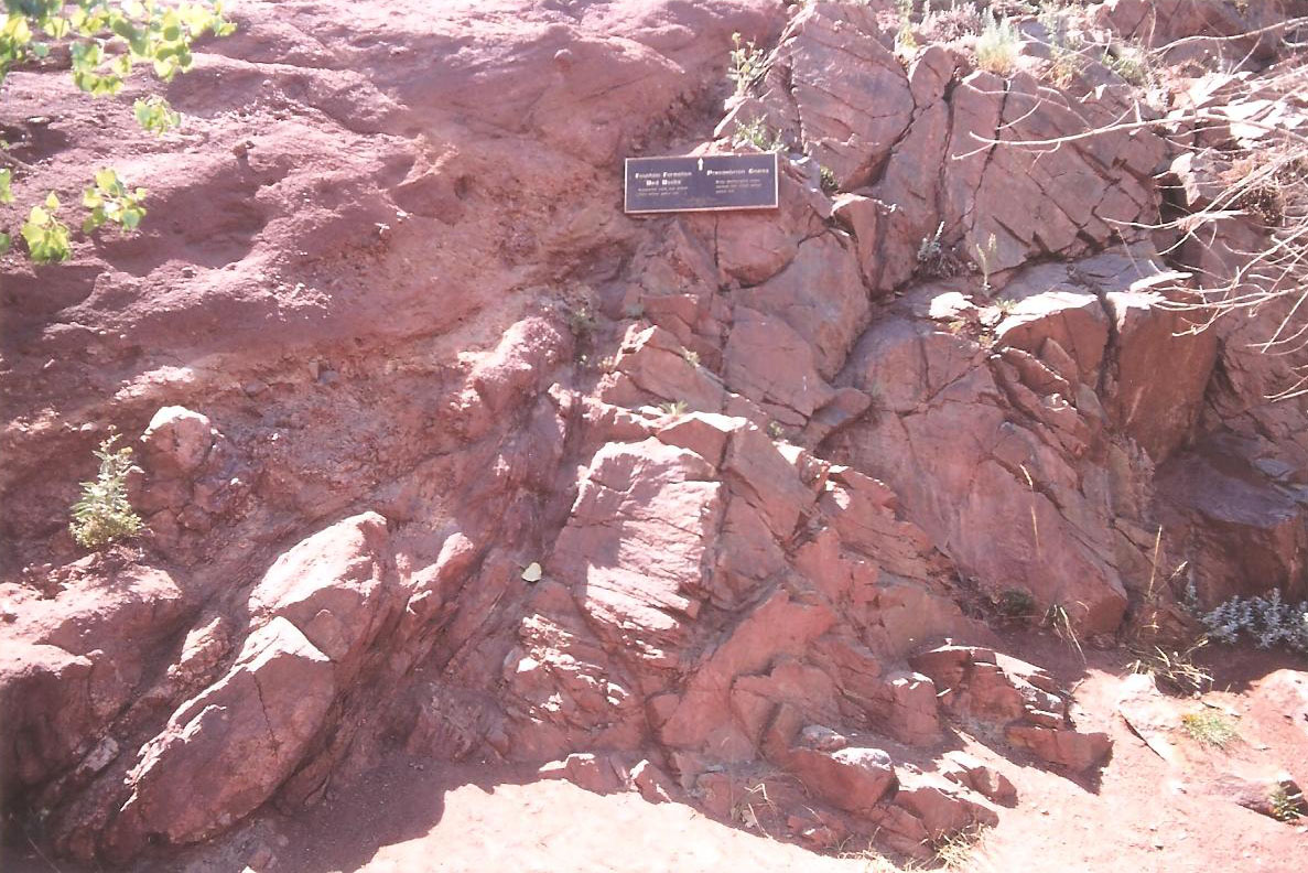
Fountain Formation
The Fountain Formation is a Pennsylvanian bedrock unit consisting primarily of conglomerate, sandstone, or arkose, in the states of Colorado and Wyoming in the United States, along the east side of the Front Range of the Rocky Mountains, and along the west edge of the Denver Basin. Origin of name The Fountain Formation was named by geologist W. C. Cross in 1894 for exposures along Fountain Creek in El Paso County, Colorado. Stratigraphy The Fountain Formation is found along the Front Range of Colorado. To the north, the Formation unconformably overlies Precambrian granite and gneiss. To the south, it overlies Mississippian, Ordovician and Devonian Limestones, as well as Cambrian sandstones. Outcrops of the formation typically dip steeply to the east. Depositional environment The formation was formed by the erosion of the Ancestral Rocky Mountains, and deposition by fluvial processes as alluvial fans. The characteristic predominant red color and the composition of the Fo ... [...More Info...] [...Related Items...] OR: [Wikipedia] [Google] [Baidu] |
Trackway
Historic roads (historic trails in USA and Canada) are paths or routes that have historical importance due to their use over a period of time. Examples exist from prehistoric times until the early 20th century. They include ancient trackways, long-lasting roads, important trade routes, and migration trails. Many historic routes, such as the Silk Road, the Amber Road, and the Royal Road of the Persian Empire, covered great distances and their impact on human settlements remain today. The Post Track, a prehistoric causeway in the valley of the River Brue in the Somerset Levels, England, is one of the oldest known constructed trackways and dates from around 3800 BCE. The world's oldest known paved road was constructed in Egypt some time between 2600 and 2200 BC. The Romans were the most significant road builders of the ancient world. At the peak of the Roman Empire there were more than of roads, of which over were stone-paved.Gabriel, Richard A. ''The Great Armies of Antiquit ... [...More Info...] [...Related Items...] OR: [Wikipedia] [Google] [Baidu] |
Dinosaur
Dinosaurs are a diverse group of reptiles of the clade Dinosauria. They first appeared during the Triassic period, between 243 and 233.23 million years ago (mya), although the exact origin and timing of the evolution of dinosaurs is the subject of active research. They became the dominant terrestrial vertebrates after the Triassic–Jurassic extinction event 201.3 mya; their dominance continued throughout the Jurassic and Cretaceous periods. The fossil record shows that birds are feathered dinosaurs, having evolved from earlier theropods during the Late Jurassic epoch, and are the only dinosaur lineage known to have survived the Cretaceous–Paleogene extinction event approximately 66 mya. Dinosaurs can therefore be divided into avian dinosaurs—birds—and the extinct non-avian dinosaurs, which are all dinosaurs other than birds. Dinosaurs are varied from taxonomic, morphological and ecological standpoints. Birds, at over 10,700 living species, ar ... [...More Info...] [...Related Items...] OR: [Wikipedia] [Google] [Baidu] |
Morrison Formation
The Morrison Formation is a distinctive sequence of Upper Jurassic sedimentary rock found in the western United States which has been the most fertile source of dinosaur fossils in North America. It is composed of mudstone, sandstone, siltstone, and limestone and is light gray, greenish gray, or red. Most of the fossils occur in the green siltstone beds and lower sandstones, relics of the rivers and floodplains of the Jurassic period. It is centered in Wyoming and Colorado, with outcrops in Montana, North Dakota, South Dakota, Nebraska, Kansas, the panhandles of Oklahoma and Texas, New Mexico, Arizona, Utah, and Idaho. Equivalent rocks under different names are found in Canada. It covers an area of 1.5 million square kilometers (600,000 square miles), although only a tiny fraction is exposed and accessible to geologists and paleontologists. Over 75% is still buried under the prairie to the east, and much of its western paleogeographic extent was eroded during exhum ... [...More Info...] [...Related Items...] OR: [Wikipedia] [Google] [Baidu] |
Morrison, Colorado
The Town of Morrison is a home rule municipality in Jefferson County, Colorado, United States. The population was 428 at the 2010 census. Red Rocks Amphitheatre is located nearby. History This small foothills settlement is named after George Morrison (April 16, 1822 – June 11, 1895), a builder and businessman who left a mark not only on the town that now bears his name, but on the history of the area. A stonemason who immigrated from Canada to the Mt. Vernon area in 1859, he helped found the town of Mt. Vernon and built the Mt. Vernon House, seat of the territorial government under Robert Steele, and an important stop for travelers on the Mt. Vernon Toll Road from Denver to the goldfields of the Rocky Mountains. He became a U.S. citizen on May 22, 1862.Brown, Georgina. 1976. ''Shining Mountains''. Library of Congress catalog # 75-41547, 248 p. (Index compiled by Ginna C. Snyder, Foothills Genealogical Society of Colorado, Inc., 1985.) George Morrison later moved south to Be ... [...More Info...] [...Related Items...] OR: [Wikipedia] [Google] [Baidu] |

%2C_the_Indian_territories.jpg)


