|
Debed
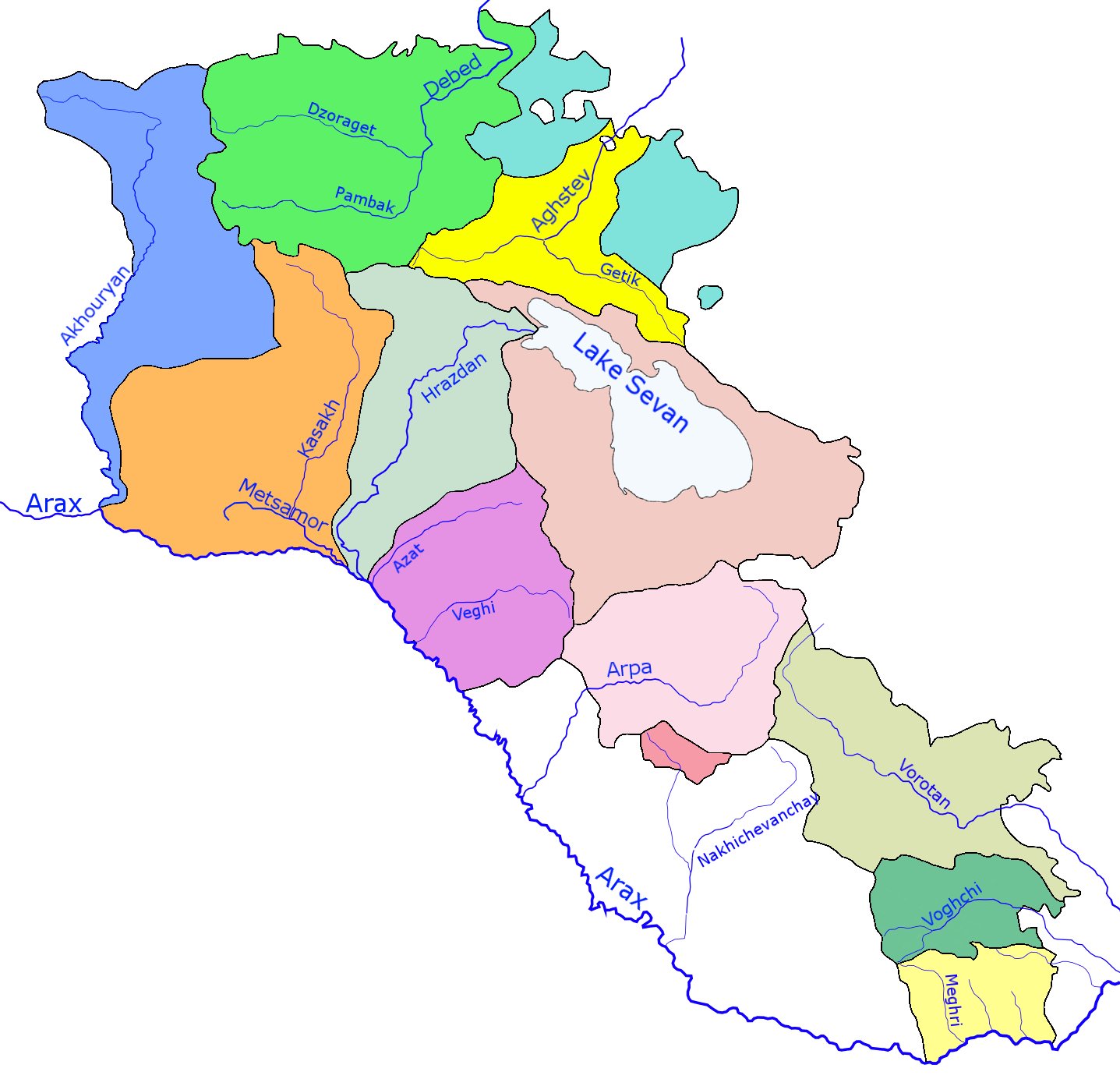
The Debed ( hy, Դեբեդ) or Debeda ( ka, დებედა) is a river in Armenia and Georgia. It also serves as a natural boundary between Armenia and Georgia at the village Sadakhlo, Georgia. It is long, and has a drainage basin of . The river originates in Armenia and is formed at the confluence of the Dzoraget and Pambak. It ends in Georgia where it feeds into the Khrami, a tributary of Kura. See also *List of lakes of Armenia
This is a list of lakes of ...
[...More Info...] [...Related Items...] OR: [Wikipedia] [Google] [Baidu] |
Alaverdi, Armenia
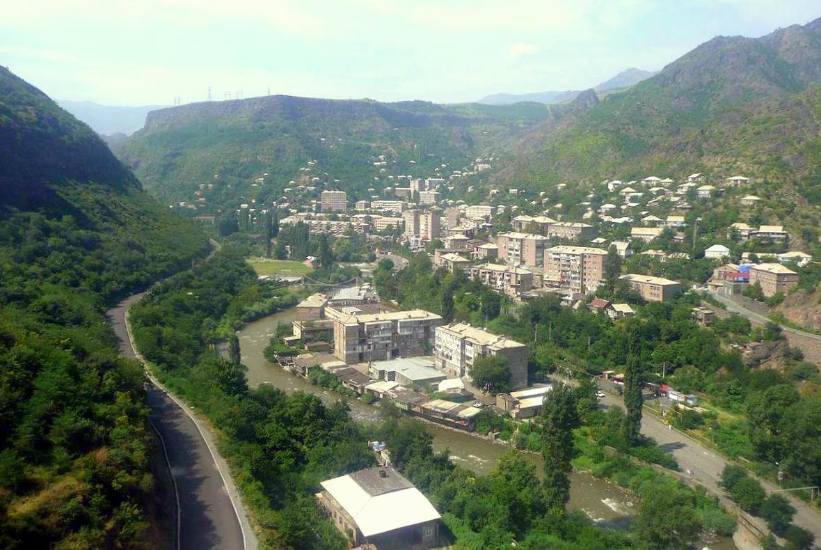
Alaverdi ( hy, Ալավերդի, ), is a town and municipal community in the Lori Province at the northeastern part of Armenia, near the border with Georgia. It is located at the only direct rail link between Armenia and Georgia. Situated at the bottom of the Debed river gorge, Alaverdi is an important commercial and industrial centre in northern Armenia. As of the 2011 census, the population of the town is 13,343, down from 26,300 reported in 1989. Currently, the town has an approximate population of 11,000 as per the 2016 official estimate. Etymology Historically, the area around Alaverdi was known as Manasgomer or Manits Gom during the medieval period. Starting from the 17th century, the settlement became known as Alaverdi, derived from the name of a 17th-century Turkic ''Borçalı'' tribe leader ''Allahverdi Mollaoğlu Tarkhan''. However, Alaverdi was formed as a settlement known as Manes (from historical Manits Gom) only in 1899, when the copper smelter was opened near ... [...More Info...] [...Related Items...] OR: [Wikipedia] [Google] [Baidu] |
Rivers Of Armenia
The rivers of Armenia are part of either the Caspian Sea or Lake Sevan watersheds. Throughout history Armenia has been called Nairi by the Assyrians meaning the "Land of the lakes and rivers" There are 16 rivers over long in or bordering Armenia. The longest river, Aras, has been mentioned in the Old Testament as one of the four sacred rivers of the Garden of Eden. There are about 9480 rivers and small streams in Armenia. List of rivers Approximately 4.7 percent of the territory of Armenia consists of rivers. The longest river of Armenia is the Aras (also called Araks, Arax), which lies on the country's border with Iran and a large part of the border with Turkey. Its major tributaries are the Akhuryan, Kasagh, Hrazdan, Azat, Arpa, Vorotan and Voghji rivers. The longest rivers in northwest part of the country are the Debed and Aghstafa, while shorter ones include the Dzoraget and the Pambak. Most of Armenia is drained into the Caspian Sea by the Araks or its tribu ... [...More Info...] [...Related Items...] OR: [Wikipedia] [Google] [Baidu] |
Sadakhlo
Sadakhlo ( Georgian: სადახლო, az, Sadaxlı) is a village in Georgia located in the southern part of country in the administrative territory of Marneuli Municipality (Kvemo Kartli Region) at the border with Armenia. The village is about south of the municipal center Marneuli and south of capital Tbilisi and is situated along the left bank of the Debeda river. Sadakhlo is the largest village in Georgia, and is the center of the eponymous administrative community (თემი, temi) that includes 4 other nearby villages: Burma, Tazakendi, Molaoghli, and Khuldara. The Sadakhlo market played a remarkable role in the interaction between Azerbaijanis and Armenians, in light of the Nagorno-Karabakh conflict. Sadakhlo is almost entirely populated with Azerbaijanis, and is an important bordertown with Armenia. Since Georgia took a neutral stance in this conflict, it became a neutral territory in which both peoples could freely and safely interact with each other. Six ki ... [...More Info...] [...Related Items...] OR: [Wikipedia] [Google] [Baidu] |
Pambak (river)
The Pambak ( hy, Փամբակ), is a river in the region of Lori Province in Northern Armenia and a tributary of the Debed The Debed ( hy, Դեբեդ) or Debeda ( ka, დებედა) is a river in Armenia and Georgia. It also serves as a natural boundary between Armenia and Georgia at the village Sadakhlo, Georgia. It is long, and has a drainage basin of . The ... river. It originates in the Pambak Mountains and flows west to east through spectacular gorges around Bazum Mountains. It finally feeds into the Debed river near Dzoragyugh, which ultimately drains to the Kura. References Rivers of Armenia {{Armenia-river-stub ... [...More Info...] [...Related Items...] OR: [Wikipedia] [Google] [Baidu] |
Geography Of Armenia
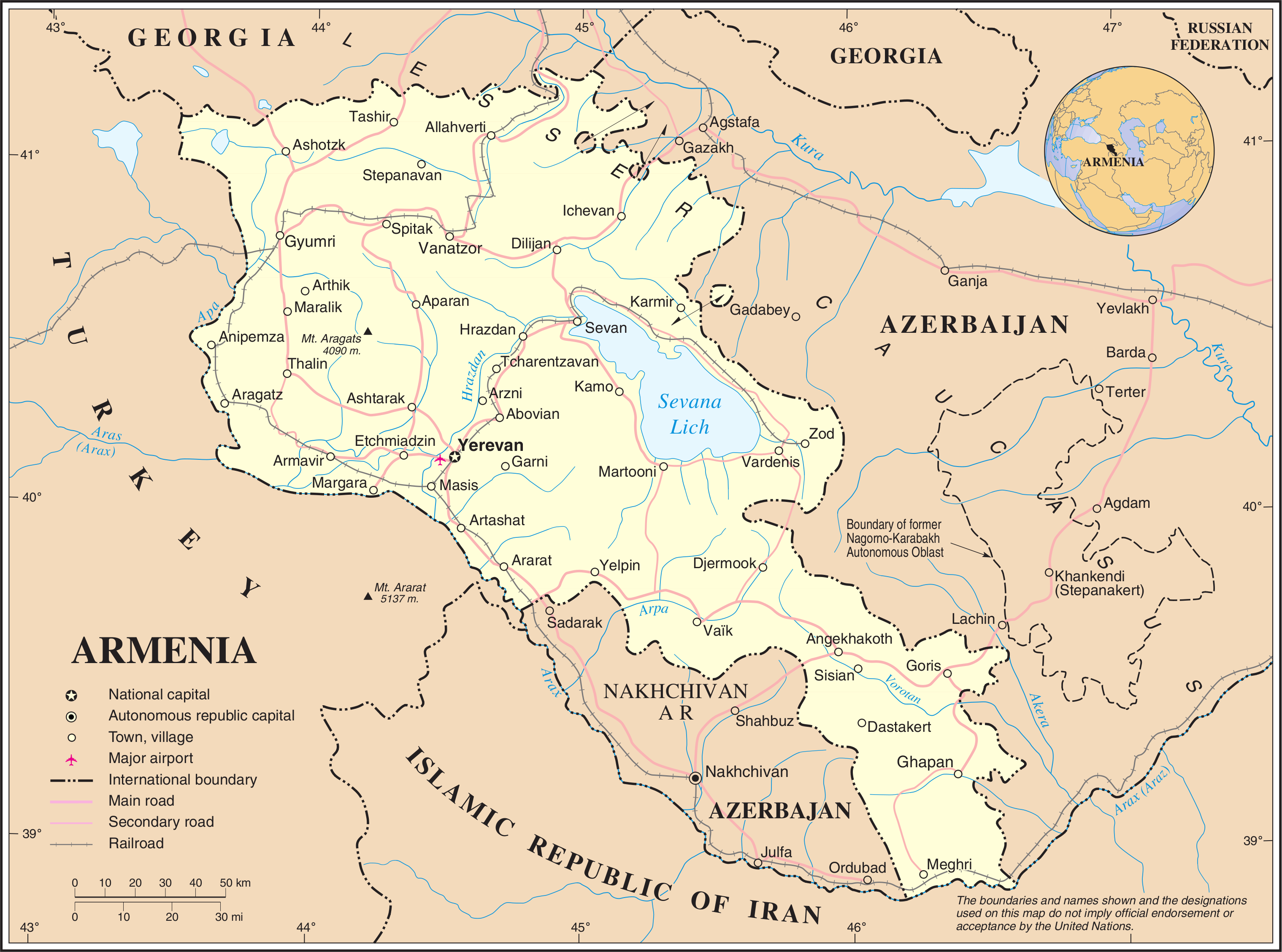
Armenia is a landlocked country in West Asia, situated in the Transcaucasus region of the South Caucasus, bordered on the north and east by Georgia and Azerbaijan and on the south and west by Iran, Azerbaijan's exclave Nakhchivan, and Turkey. The terrain is mostly mountainous and flat, with fast flowing rivers and few forests but with many trees. The climate is highland continental: hot summers and cold winters. The land rises to 4,090 m above sea-level at Mount Aragats. Physical environment Armenia is located in the southern Caucasus, the region southwest of Russia between the Black Sea and the Caspian Sea. Modern Armenia occupies part of historical Armenia, whose ancient centers were in the valley of the Araks River and the region around Lake Van in Turkey. Armenia is bordered on the north by Georgia, on the east by Azerbaijan, on the south by Iran, and on the west by Turkey. Topography and drainage Twenty-five million years ago, a geological upheaval pushed up the Ear ... [...More Info...] [...Related Items...] OR: [Wikipedia] [Google] [Baidu] |
Dzoraget (river)
The Dzoraget () is a river in the Lori region in Northern Armenia. It originates in the Bazum Mountains and flows west to east through spectacular gorges around Stepanavan. It finally feeds into the river Debed near Dzoragyugh, which ultimately drains to the Kura. ''Dzoraget'' is a compound word in Armenian meaning ''Gorge-river'' and formed with the lexemes ձոր ('gorge') and գետ ('river') joined by the interfix ա . The gorge in certain places (e.g. at Kurtan) is over in depth. Rafting The Armenian Travel Bureau considers the Dzoraget River the only Armenian river suitable for rafting. The commonest rafting route begins at the Dzoraget bridge, near the town of Stepanavan. Rafting on the river is concentrated in the Dzoraget Canyon, which is in some places as deep as 300 meters. Towns and villages Towns and villages along the river include: Stepanavan, Amrakits, Lori Berd, Agarak, Vardablur, Kurtan, Arevatsag, and Dzoragyukh. Gallery Image:Dzoragetatstepanav ... [...More Info...] [...Related Items...] OR: [Wikipedia] [Google] [Baidu] |
Khrami
, name_etymology = , image = Khrami River Kirach Muganlo.jpg , image_size = , image_caption = The Khrami near Kirach Muganlo, Georgia , map = KhramiRiver800px.svg , map_size = , map_caption = , pushpin_map = , pushpin_map_size = , pushpin_map_caption= , subdivision_type1 = Countries , subdivision_name1 = Georgia and Azerbaijan , subdivision_type2 = , subdivision_name2 = , subdivision_type3 = Region , subdivision_name3 = Caucasus , subdivision_type4 = , subdivision_name4 = , subdivision_type5 = , subdivision_name5 = , length = , width_min = , width_avg = , width_max = , depth_min = , depth_avg = , depth_max = , discharge1_location= directly downstream into Kura , discharge1_min = , discharge1_avg = , discharge1_max = , source1 = Lesser Caucasus , source1_lo ... [...More Info...] [...Related Items...] OR: [Wikipedia] [Google] [Baidu] |
Armenia–Georgia Border
The Armenia–Georgia border ( hy, Հայաստան-Վրաստան սահման, translit=Hayastan–Vrastan sahman, ka, სომხეთ-საქართველოს საზღვარი, ') is the international boundary between Armenia and Georgia. It is in length and runs from the tripoint with Turkey in the west to the tripoint with Azerbaijan in the east. Description The border starts in the west at the tripoint with Turkey and proceeds overland to the tripoint with Azerbaijan via a series of irregular lines and a small section in the east along the Debed river. The western, more mountainous section of the boundary contains two lakes situated quite close to the frontier – Madatapa (in Georgia) and Arpi (in Armenia). History During the 19th the Caucasus region was contested between the declining Ottoman Empire, Persia and Russia, which was expanding southwards. Russia formally annexed the eastern Georgian Kingdom of Kartli and Kakheti in 1801, followed by the ... [...More Info...] [...Related Items...] OR: [Wikipedia] [Google] [Baidu] |
International Rivers Of Europe
International is an adjective (also used as a noun) meaning "between nations". International may also refer to: Music Albums * ''International'' (Kevin Michael album), 2011 * ''International'' (New Order album), 2002 * ''International'' (The Three Degrees album), 1975 *''International'', 2018 album by L'Algérino Songs * The Internationale, the left-wing anthem * "International" (Chase & Status song), 2014 * "International", by Adventures in Stereo from ''Monomania'', 2000 * "International", by Brass Construction from ''Renegades'', 1984 * "International", by Thomas Leer from ''The Scale of Ten'', 1985 * "International", by Kevin Michael from ''International'' (Kevin Michael album), 2011 * "International", by McGuinness Flint from ''McGuinness Flint'', 1970 * "International", by Orchestral Manoeuvres in the Dark from '' Dazzle Ships'', 1983 * "International (Serious)", by Estelle from '' All of Me'', 2012 Politics * Political international, any transnational organization ... [...More Info...] [...Related Items...] OR: [Wikipedia] [Google] [Baidu] |
International Rivers Of Asia
International is an adjective (also used as a noun) meaning "between nations". International may also refer to: Music Albums * ''International'' (Kevin Michael album), 2011 * ''International'' (New Order album), 2002 * ''International'' (The Three Degrees album), 1975 *''International'', 2018 album by L'Algérino Songs * The Internationale, the left-wing anthem * "International" (Chase & Status song), 2014 * "International", by Adventures in Stereo from ''Monomania'', 2000 * "International", by Brass Construction from ''Renegades'', 1984 * "International", by Thomas Leer from ''The Scale of Ten'', 1985 * "International", by Kevin Michael from ''International'' (Kevin Michael album), 2011 * "International", by McGuinness Flint from ''McGuinness Flint'', 1970 * "International", by Orchestral Manoeuvres in the Dark from '' Dazzle Ships'', 1983 * "International (Serious)", by Estelle from '' All of Me'', 2012 Politics * Political international, any transnational organization ... [...More Info...] [...Related Items...] OR: [Wikipedia] [Google] [Baidu] |
Rivers Of Georgia (country) , a list of rivers of the American state of Georgia
{{geodis ...
List of rivers of Georgia may refer to: * List of rivers of Georgia (country), a list of rivers of the country of Georgia * List of rivers of Georgia (U.S. state) List of rivers of Georgia (U.S. state). By drainage basin This list is arranged by drainage basin, with respective tributaries indented under each larger stream's name. Atlantic Ocean *Savannah River ** Abercorn Creek ** Black Creek ** Knoxb ... [...More Info...] [...Related Items...] OR: [Wikipedia] [Google] [Baidu] |
Great Soviet Encyclopedia
The ''Great Soviet Encyclopedia'' (GSE; ) is one of the largest Russian-language encyclopedias, published in the Soviet Union from 1926 to 1990. After 2002, the encyclopedia's data was partially included into the later ''Bolshaya rossiyskaya entsiklopediya'' (or '' Great Russian Encyclopedia'') in an updated and revised form. The GSE claimed to be "the first Marxist–Leninist general-purpose encyclopedia". Origins The idea of the ''Great Soviet Encyclopedia'' emerged in 1923 on the initiative of Otto Schmidt, a member of the Russian Academy of Sciences. In early 1924 Schmidt worked with a group which included Mikhail Pokrovsky, (rector of the Institute of Red Professors), Nikolai Meshcheryakov (Former head of the Glavit, the State Administration of Publishing Affairs), Valery Bryusov (poet), Veniamin Kagan (mathematician) and Konstantin Kuzminsky to draw up a proposal which was agreed to in April 1924. Also involved was Anatoly Lunacharsky, People's Commissar of Education ... [...More Info...] [...Related Items...] OR: [Wikipedia] [Google] [Baidu] |


