|
Drakensberg
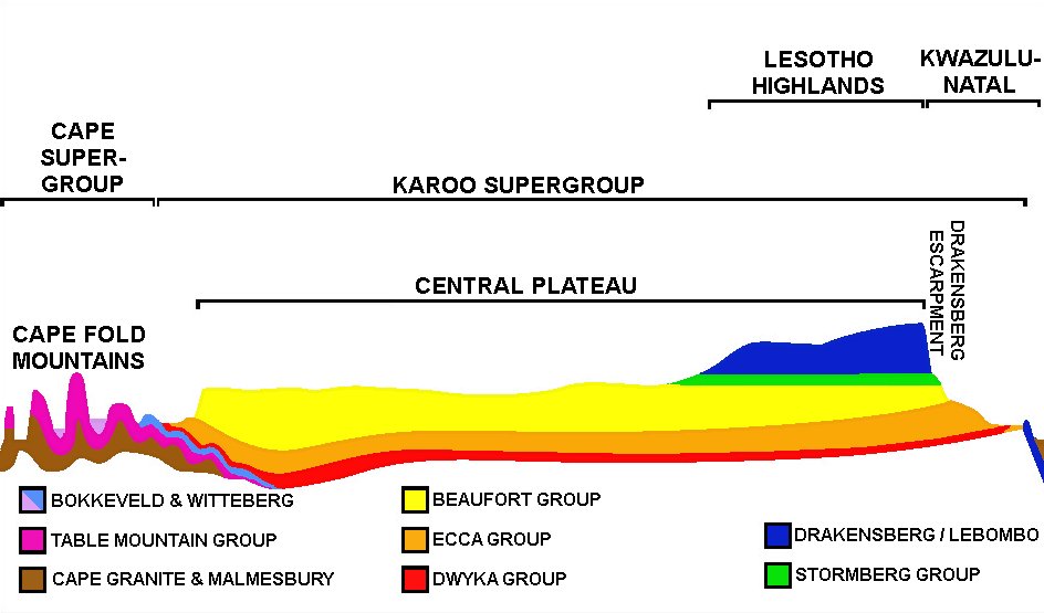
The Drakensberg (Zulu language, Zulu: uKhahlamba, Sotho language, Sotho: Maloti, Afrikaans: Drakensberge) is the eastern portion of the Great Escarpment, Southern Africa, Great Escarpment, which encloses the central South Africa#Geography, Southern African plateau. The Great Escarpment reaches its greatest elevation – within the border region of South Africa and Lesotho. The Drakensberg escarpment stretches for more than from the Eastern Cape, Eastern Cape Province in the South, then successively forms, in order from south to north, the border between Lesotho and the Eastern Cape and the border between Lesotho and KwaZulu-Natal, KwaZulu-Natal Province. Thereafter it forms the border between KwaZulu-Natal and the Free State (South African province), Free State, and next as the border between KwaZulu-Natal and Mpumalanga, Mpumalanga Province. The escarpment winds north from there, through Mpumalanga, where it includes features such as the Blyde River Canyon, Three Rondavels, ... [...More Info...] [...Related Items...] OR: [Wikipedia] [Google] [Baidu] |
Great Escarpment, Southern Africa
The Great Escarpment is a major topographical feature in Africa that consists of steep slopes from the high central Southern African plateauAtlas of Southern Africa. (1984). p. 13. Reader's Digest Association, Cape Town downward in the direction of the oceans that surround southern Africa on three sides.McCarthy, T. & Rubidge, B. (2005). ''The Story of Earth and Life''. pp. 16–7,192–195, 202–205, 245–248, 263, 267–269. Struik Publishers, Cape Town.Truswell, J.F. (1977). ''The Geological Evolution of South Africa''. pp. 151–153,157–159,184–188, 190. Purnell, Cape Town. While it lies predominantly within the borders of South Africa, in the east the escarpment extends northward to form the border between Mozambique and Zimbabwe, continuing on beyond the Zambezi river valley to form the Muchinga Escarpment in eastern Zambia. In the west, it extends northward into Namibia and Angola.The Times comprehensive Atlas of the world (1999). pp. 88–89. Times Books Group, Lon ... [...More Info...] [...Related Items...] OR: [Wikipedia] [Google] [Baidu] |
KwaZulu-Natal
KwaZulu-Natal (, also referred to as KZN) is a Provinces of South Africa, province of South Africa that was created in 1994 when the government merged the Zulu people, Zulu bantustan of KwaZulu ("Place of the Zulu" in Zulu language, Zulu) and Natal Province. It is located in the southeast of the country, with a long shoreline on the Indian Ocean. It shares borders with three other provinces and the countries of Mozambique, Eswatini and Lesotho. Its capital is Pietermaritzburg, and its largest city is Durban, which is also the Port of Durban, city with the largest port in sub-saharan Africa. It is the second-most populous province in South Africa, after Gauteng. Two areas in KwaZulu-Natal have been declared UNESCO World Heritage Sites: the iSimangaliso Wetland Park and the uKhahlamba Drakensberg Park. These areas are important to the surrounding ecosystems. During the 1830s and early 1840s, the northern part of what is now KwaZulu-Natal was established as the Zulu Kingdom. The ... [...More Info...] [...Related Items...] OR: [Wikipedia] [Google] [Baidu] |
Thabana Ntlenyana
Thabana Ntlenyana () is the highest mountain in southern Africa. It stands tall within the Maloti Mountains that crest Lesotho. The peak's name means "beautiful little mountain" in the Sesotho language, from ''thaba'' (mountain), the diminutive ''-na'', and ''ntlenyana'' (beautiful). Thabana Ntlenyana is ranked 11th in the world by topographic isolation. Geography Thabana Ntlenyana is situated on the Mohlesi ridge, north of the treacherous Sani Pass. The peak is climbed as part of a "Grand Traverse" of the Maloti, which follows a large system of peaks within the Maloti Mountains, Maloti (Maluti) and the broader Drakensberg. Thabana Ntlenyana, like the broader highlands around it, is made of Amygdule, amygdaloidal flood basalt that formed during the Upper Triassic and Lower Jurassic epochs. Nearby the mountain are the headwaters of the Orange River, which runs approximately to the west before draining into the Atlantic Ocean. Together with its main tributary, the Vaal River, ... [...More Info...] [...Related Items...] OR: [Wikipedia] [Google] [Baidu] |
South Africa
South Africa, officially the Republic of South Africa (RSA), is the Southern Africa, southernmost country in Africa. Its Provinces of South Africa, nine provinces are bounded to the south by of coastline that stretches along the Atlantic Ocean, South Atlantic and Indian Ocean; to the north by the neighbouring countries of Namibia, Botswana, and Zimbabwe; to the east and northeast by Mozambique and Eswatini; and it encloses Lesotho. Covering an area of , the country has Demographics of South Africa, a population of over 64 million people. Pretoria is the administrative capital, while Cape Town, as the seat of Parliament of South Africa, Parliament, is the legislative capital, and Bloemfontein is regarded as the judicial capital. The largest, most populous city is Johannesburg, followed by Cape Town and Durban. Cradle of Humankind, Archaeological findings suggest that various hominid species existed in South Africa about 2.5 million years ago, and modern humans inhabited the ... [...More Info...] [...Related Items...] OR: [Wikipedia] [Google] [Baidu] |
God's Window
Blyde River Canyon Nature Reserve (or Motlatse Canyon Provincial Nature Reserve) is situated in the Drakensberg escarpment region of eastern Mpumalanga, South Africa. The reserve protects the Blyde River Canyon, including sections of the Ohrigstad and Blyde Rivers and the geological formations around Bourke's Luck Potholes, where the Treur River tumbles into the Blyde below. Southwards of the canyon, the reserve follows the escarpment, to include the Devil's and God's Window, the latter a popular viewpoint to the lowveld at the reserve's southern extremity. The Mogologolo (1,794 m), Mariepskop (1,944 m) and Hebronberg (1,767 m) massifs are partially included in the reserve. Elevation varies from 560 m to 1,944 m above sea level. Its resort areas are F.H. Odendaal and Swadeni, the latter only accessible from Limpopo province. The area of approximately is administered by the Mpumalanga Parks Board. Bourke's Luck Potholes This geological feature and day visitors' attractio ... [...More Info...] [...Related Items...] OR: [Wikipedia] [Google] [Baidu] |
Hoedspruit
Hoedspruit (Afrikaans for ''Hat Creek'') is a town situated at the foot of the Klein Drakensberg (Afrikaans for "Small Dragon Mountains" range), in the Limpopo province of South Africa, on the railway line from Tzaneen to Kaapmuiden. History Pre-Colonialization The Stone Age artifacts and sites from all three periods suggest continuous use by early humans. Early and Middle Iron Age sites near Hoedspruit have been excavated on the Happyland farm, dating between AD 450 and 1000. Colonialization and Settlement Dawid Johannes Joubert became the initial owner of Hoedspruit farm, acquiring the land in 1844 and settling in the region between the Blyde and present-day Zandspruit rivers. On 5 May 1848, Joubert officially registered the farm at the land office in Ohrigstad, granting Hoedspruit its first recognition and registration as a town and municipality. In the 1850s, Ohrigstad grew into the central town of the area, but only older settlers were permitted to live in and a ... [...More Info...] [...Related Items...] OR: [Wikipedia] [Google] [Baidu] |
Wolkberg
The Wolkberg is a mountain range in Tzaneen, Limpopo Province, South Africa. It is a northern termination and a subrange of the Drakensberg mountain range which lines up from Eastern Cape, Lesotho, Kwazulu Natal and Mpumalanga. At 2200 m (7200 ft) above sea level, it is the highest mountain range in Limpopo, together with the Iron crown mountain. The range extends for about in a NW/SE direction north of Sekhukhuneland. The nearest towns are Haenertsburg and Tzaneen. Physiography The range forms a high plateau reaching up to 2126 m in height at the Ysterkroon, its highest point. Other conspicuous peaks are 2050 m high Serala, 1838 m high Mamotswiri, 1667 m high Magopalone and 1611 m high Selemole. The Wolkberg is the source of many small mountain streams, as well as the Mohlapitse and the Ga-Selati River, tributaries of the Olifants River. Ecology Weather can change very fast from clear skies to becoming misty, with the highest reac ... [...More Info...] [...Related Items...] OR: [Wikipedia] [Google] [Baidu] |
Afrikaner
Afrikaners () are a Southern African ethnic group descended from predominantly Dutch settlers who first arrived at the Cape of Good Hope in 1652.Entry: Cape Colony. ''Encyclopædia Britannica Volume 4 Part 2: Brain to Casting''. Encyclopædia Britannica, Inc. 1933. James Louis Garvin, editor. Until 1994, they dominated South Africa's politics as well as the country's commercial agricultural sector. Afrikaans, a language which evolved from the Dutch dialect of South Holland, is the mother tongue of Afrikaners and most Cape Coloureds. According to the South African National Census of 2022, 10.6% of South Africans claimed to speak Afrikaans as a first language at home, making it the country's third-largest home language after Zulu and Xhosa. The arrival of Portuguese explorer Vasco da Gama at Calicut, India, in 1498 opened a gateway of free access to Asia from Western Europe around the Cape of Good Hope. This access necessitated the founding and safeguarding of tra ... [...More Info...] [...Related Items...] OR: [Wikipedia] [Google] [Baidu] |
Mpumalanga
Mpumalanga () is one of the nine provinces of South Africa. The name means "East", or literally "The Place Where the Sun Rises" in the Nguni languages. Mpumalanga lies in eastern South Africa, bordering Eswatini and Mozambique. It shares borders with the South African provinces of Limpopo to the north, Gauteng to the west, the Free State (province), Free State to the southwest, and KwaZulu-Natal to the south. The capital is Mbombela. Mpumalanga was formed in 1994, when the area that was the Eastern Transvaal (province), Transvaal was merged with the former bantustans KaNgwane, KwaNdebele and parts of Lebowa and Gazankulu. Although the contemporary borders of the province were formed only at the end of apartheid, the region and its surroundings have a history that extends back thousands of years. Much of its history and current significance are as a region of trade. History Precolonial Era Archeological sites in the Mpumalanga region indicate settlement by humans and ... [...More Info...] [...Related Items...] OR: [Wikipedia] [Google] [Baidu] |
Lesotho
Lesotho, formally the Kingdom of Lesotho and formerly known as Basutoland, is a landlocked country in Southern Africa. Entirely surrounded by South Africa, it is the largest of only three sovereign enclave and exclave, enclaves in the world, the others being San Marino and Vatican City, which are surrounded by Italy. Lesotho is situated in the Maloti Mountains and contains the Thabana Ntlenyana, highest peak in Southern Africa. It has an area of over and has a population of about 2.311 million. Its Capital city, capital and largest city is Maseru. Lesotho was formed in 1824 by Moshoeshoe I, King Moshoeshoe I. Continuous encroachments by Dutch settlers made the King enter into an agreement with the United Kingdom to become a protectorate in 1868 and, in 1884, a crown colony. History of Lesotho, It achieved independence in 1966, and was subsequently ruled by the Basotho National Party (BNP) for two decades. Its constitutional government was restored in 1993 after seven years o ... [...More Info...] [...Related Items...] OR: [Wikipedia] [Google] [Baidu] |
Free State (South African Province)
The Free State ( ; ; ; ; ), formerly known as the Orange Free State, is a province of South Africa. Its capital is Bloemfontein, which is also South Africa's judicial capital. Its historical origins lie in the Boer republic called the Orange Free State and later the Orange Free State Province. History The current borders of the province date from 1994 when the Bantustans were abolished and reincorporated into South Africa. It is also the only one of the four original provinces of South Africa not to undergo border changes, apart from the reincorporation of Bantustans, and its borders date from before the outbreak of the Boer War. Geography The Free State is situated on a succession of flat grassy plains sprinkled with pastureland, resting on a general elevation of 3,800 feet only broken by the occasional hill or kopje. The rich soil and pleasant climate allow for a thriving agricultural industry. The province is high-lying, with almost all land being 1,000 metres above ... [...More Info...] [...Related Items...] OR: [Wikipedia] [Google] [Baidu] |


