|
Cumberland House, Saskatchewan
Cumberland House is a community in Census Division No. 18 in northeast Saskatchewan, Canada on the Saskatchewan River. It is the oldest settler community in Saskatchewan and has a population of about 2,000 people. Cumberland House Provincial Park, which provides tours of an 1890s powder house built by the Hudson's Bay Company, is located nearby. The community consists of the Northern Village of Cumberland House with a population of 772 and the adjoining Cumberland House Cree Nation with a population of 715. The community is served by the Cumberland House Airport and by Saskatchewan Highway 123. Cumberland House Cree Nation The population of Cumberland House consists of mostly First Nations people, including Cree and Métis. Cumberland House was and is a Cree "n" dialect community, known in Cree as "Waskahikanihk". In March 2013, Cumberland House Cree Nation had a registered population of 1387 with 814 members living on-reserve or crown land and 573 members living off-res ... [...More Info...] [...Related Items...] OR: [Wikipedia] [Google] [Baidu] |
Northern Village (Saskatchewan)
Northern village may refer to: * Northern village (Quebec), a municipal status type in Quebec, Canada * Northern village (Saskatchewan), a municipal status type in Saskatchewan, Canada {{Geodis ... [...More Info...] [...Related Items...] OR: [Wikipedia] [Google] [Baidu] |
Métis People (Canada)
The Métis ( ; Canadian ) are Indigenous peoples who inhabit Canada's three Prairie Provinces, as well as parts of British Columbia, the Northwest Territories, and the Northern United States. They have a shared history and culture which derives from specific mixed European (primarily French) and Indigenous ancestry which became a distinct culture through ethnogenesis by the mid-18th century, during the early years of the North American fur trade. In Canada, the Métis, with a population of 624,220 as of 2021, are one of three major groups of Indigenous peoples that were legally recognized in the Constitution Act of 1982, the other two groups being the First Nations and Inuit. Smaller communities who self-identify as Métis exist in Canada and the United States, such as the Little Shell Tribe of Chippewa Indians of Montana. The United States recognizes the Little Shell Tribe as an Ojibwe Native American tribe. Alberta is the only Canadian province with a recognized Métis ... [...More Info...] [...Related Items...] OR: [Wikipedia] [Google] [Baidu] |
Cumberland Lake
Cumberland Lake is a glacial lake of Saskatchewan, Canada. It is located in the Cumberland Delta in east-central Saskatchewan about from the Manitoba border. Cumberland House and Cumberland House Provincial Historic Park are located on the south shore and is accessed by Highway 123. The community has been subject to floods from the Saskatchewan River. The lake was an interior hub of fur trade routes travelled by Voyageurs during the fur trade era.''Fur Trade Canoe Routes of Canada/ Then and Now'' by Eric W. Morse Canada National and Historic Parks Branch, first printing 1969. Fish species The lake supports a variety of fish species. These include walleye, sauger, yellow perch, northern pike, lake whitefish, goldeye, mooneye, white sucker, shorthead redhorse, longnose sucker, lake sturgeon and burbot. See also *List of lakes in Saskatchewan *North American fur trade The North American fur trade is the commercial trade in furs in North America. Various Indigenous peopl ... [...More Info...] [...Related Items...] OR: [Wikipedia] [Google] [Baidu] |
York Factory
York Factory was a settlement and Hudson's Bay Company (HBC) factory (trading post) located on the southwestern shore of Hudson Bay in northeastern Manitoba, Canada, at the mouth of the Hayes River, approximately south-southeast of Churchill. York Factory was one of the first fur-trading posts established by the HBC, built in 1684 and used in that business for more than 270 years. The settlement was headquarters of the HBC's Northern Department from 1821 to 1873. The complex was designated a National Historic Site of Canada in 1936. In 1957, the HBC closed it down. It has been owned by the Canadian government since 1968 and the site is now operated by Parks Canada. No one lives permanently at York Factory; there is a summer residence for Parks Canada staff, and some nearby seasonal hunting camps. The wooden structure at the park site dates from 1831 and is the oldest and largest wooden structure built on permafrost in Canada. Location York Factory is located on the north ba ... [...More Info...] [...Related Items...] OR: [Wikipedia] [Google] [Baidu] |
Voyageurs
The voyageurs (; ) were 18th and 19th century French Canadians who engaged in the transporting of furs via canoe during the peak of the North American fur trade. The emblematic meaning of the term applies to places (New France, including the '' Pays d'en Haut'' and the ''Pays des Illinois'') and times where transportation of materials was mainly over long distances. The voyageurs were regarded as legendary. They were heroes celebrated in folklore and music. For reasons of promised celebrity status and wealth, this position was coveted. Despite the fame surrounding the voyageur, their life was one of toil and not nearly as glorious as folk tales make it out to be. For example, they had to be able to carry two bundles of fur over portages. Some carried up to four or five, and there is a report of a voyageur carrying seven bundles for half of a mile.Mike Hillman, "La Bonga: The Greatest Voyageur" Boundary Waters Journal Magazine, Summer 2010 Issue, pp 20–25 Hernias were com ... [...More Info...] [...Related Items...] OR: [Wikipedia] [Google] [Baidu] |
Pemmican
Pemmican (also pemican in older sources) is a mixture of tallow, dried meat, and sometimes dried berries. A calorie-rich food, it can be used as a key component in prepared meals or eaten raw. Historically, it was an important part of indigenous cuisine in certain parts of North America and it is still prepared today. The word comes from the Cree word (), which is derived from the word (), "fat, grease". The Lakota (or Sioux) word is , originally meaning "grease derived from marrow bones", with the creating a noun, and referring to small pieces that adhere to something. It was invented by the Indigenous peoples of North America. Pemmican was widely adopted as a high-energy food by Europeans involved in the fur trade and later by Arctic and Antarctic explorers, such as Captain Robert Bartlett, Ernest Shackleton, Richard E. Byrd, Fridtjof Nansen, Robert Falcon Scott, George W. DeLong, and Roald Amundsen. Ingredients Traditionally, the specific ingredients used for pemmica ... [...More Info...] [...Related Items...] OR: [Wikipedia] [Google] [Baidu] |
Athabasca Country
In fur trade days the term Athabasca Country was used for the fur-producing region around Lake Athabasca. The area was important for two reasons. The cold climate produced some of the densest and thickest beaver fur in North America. The number of furs produced was somewhat greater than its only rival, the Saskatchewan River fur trade. Secondly, the great distance from Montreal and Hudson Bay required the highly developed and efficient transportation system that characterized the Hudson's Bay Company in the nineteenth century.Catton, Ted. (2000) ''The environment and the fur trade experience in Voyageurs National Park, 1730-1870.'' National Park Service. Midwest Region, pp. 8-9. The natural centre of the trade was the Peace-Athabasca Delta at the west end of Lake Athabasca. The lake itself led eastward into relatively poor country. To the north, the Slave River and Mackenzie River led to the Arctic Ocean. To the west, the Peace River (Canada) led to the Rocky Mountains. To ... [...More Info...] [...Related Items...] OR: [Wikipedia] [Google] [Baidu] |
Methye Portage
The Methye Portage or Portage La Loche in northwestern Saskatchewan was one of the most important portages in the old fur trade route across Canada. The portage connected the Mackenzie River basin to rivers that ran east to the Atlantic. It was reached by Peter Pond in 1778 and abandoned in 1883 when steamboats began running on the Athabasca River with links to the railroad. It ranks with Grand Portage as one of the two most important and difficult portages used during the fur trade era. 'Methye' is Cree and 'La Loche' is French for a fish that is called 'burbot' in English. Although 'Methye Portage' is often used the official name since 1957 is Portage La Loche. Both names are used in historical documents, books and journals. Alexander Mackenzie in his book "Voyages from Montreal" used both Portage la Loche and Mithy-Ouinigam Portage (in 1789–1793). History The Methye Portage had been in use by indigenous peoples as a trade route for generations. They introduced it to ... [...More Info...] [...Related Items...] OR: [Wikipedia] [Google] [Baidu] |
Churchill River (Hudson Bay)
The Churchill River () is a major river in Alberta, Saskatchewan and Manitoba, Canada. From the head of the Churchill Lake it is long. It was named after John Churchill, 1st Duke of Marlborough and governor of the Hudson's Bay Company from 1685 to 1691. The Cree name for the river is ''Missinipi'', meaning "big waters". The Denesuline name for the river is ''des nëdhë́'', meaning "Great River". The river is located entirely within the Canadian Shield. The drainage basin includes a number of lakes in Central-East Alberta which flow into a series of lakes in Saskatchewan and Manitoba. The main tributary, the Beaver River, joins at Lac Île-à-la-Crosse. Nistowiak Falls—the tallest falls in Saskatchewan—are on the Rapid River, which flows north, out of Lac la Ronge into Nistowiak Lake on the Churchill just north of La Ronge. A large amount of flow of the Churchill River after Manitoba–Saskatchewan border comes from the Reindeer River, which flows from Wollaston ... [...More Info...] [...Related Items...] OR: [Wikipedia] [Google] [Baidu] |
Sturgeon-Weir River
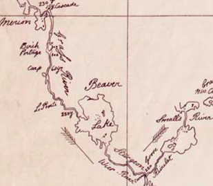
The Sturgeon-Weir River is a river in east-central Saskatchewan, Canada. It flows about south-southeast to join the Saskatchewan River at Cumberland House, Saskatchewan. It was on the main voyageurs, voyageur route from eastern Canada northeast to the Mackenzie River basin. The river is a popular wilderness canoe route in Canada. Description The river's source is Corneille Lake, near the community of Pelican Narrows, Saskatchewan, Pelican Narrows. It travels southeast, crossing Saskatchewan Highway 106 before reaching Amisk Lake. It then continues southeasterly to Sturgeon Landing and Namew Lake. It runs through the Churchill River Uplands ecoregion which is located along the southern edge of the Precambrian Shield. The area contains continuous coniferous and boreal forest, consisting of closed stands of black spruce and jack pine and a ground cover of mosses and lichens. Local relief rarely exceeds 25 m, but there are ridged steeply sloping rocky uplands and lowlands with exp ... [...More Info...] [...Related Items...] OR: [Wikipedia] [Google] [Baidu] |
Oregon Country
Oregon Country was a large region of the Pacific Northwest of North America that was subject to a long dispute between the United Kingdom and the United States in the early 19th century. The area, which had been created by the Treaty of 1818, consisted of the land north of 42°N latitude, south of 54°40′N latitude, and west of the Rocky Mountains down to the Pacific Ocean and east to the Continental Divide. Article III of the 1818 treaty gave joint control to both nations for ten years, allowed land to be claimed, and guaranteed free navigation to all mercantile trade. However, both countries disputed the terms of the international treaty. Oregon Country was the American name while the British used Columbia District for the region. British and French Canadian fur traders had entered Oregon Country prior to 1810 before the arrival of American settlers from the mid-1830s onwards, which led to the foundation of the Provisional Government of Oregon. Its coastal areas north from ... [...More Info...] [...Related Items...] OR: [Wikipedia] [Google] [Baidu] |
Lake Winnipeg
Lake Winnipeg (french: Lac Winnipeg, oj, ᐑᓂᐸᑲᒥᐠᓴᑯ˙ᑯᐣ, italics=no, Weenipagamiksaguygun) is a very large, relatively shallow lake in North America, in the province of Manitoba, Canada. Its southern end is about north of the city of Winnipeg. Lake Winnipeg is Canada's sixth-largest freshwater lake and the third-largest freshwater lake contained entirely within Canada, but it is relatively shallow (mean depth of ) excluding a narrow deep channel between the northern and southern basins. It is the eleventh-largest freshwater lake on Earth. The lake's east side has pristine boreal forests and rivers that were in 2018 inscribed as Pimachiowin Aki, a UNESCO World Heritage Site. The lake is from north to south, with remote sandy beaches, large limestone cliffs, and many bat caves in some areas. Manitoba Hydro uses the lake as one of the largest reservoirs in the world. There are many islands, most of them undeveloped. The Sagkeeng First Nation holds a reserve ... [...More Info...] [...Related Items...] OR: [Wikipedia] [Google] [Baidu] |


