|
Nuristani Languages
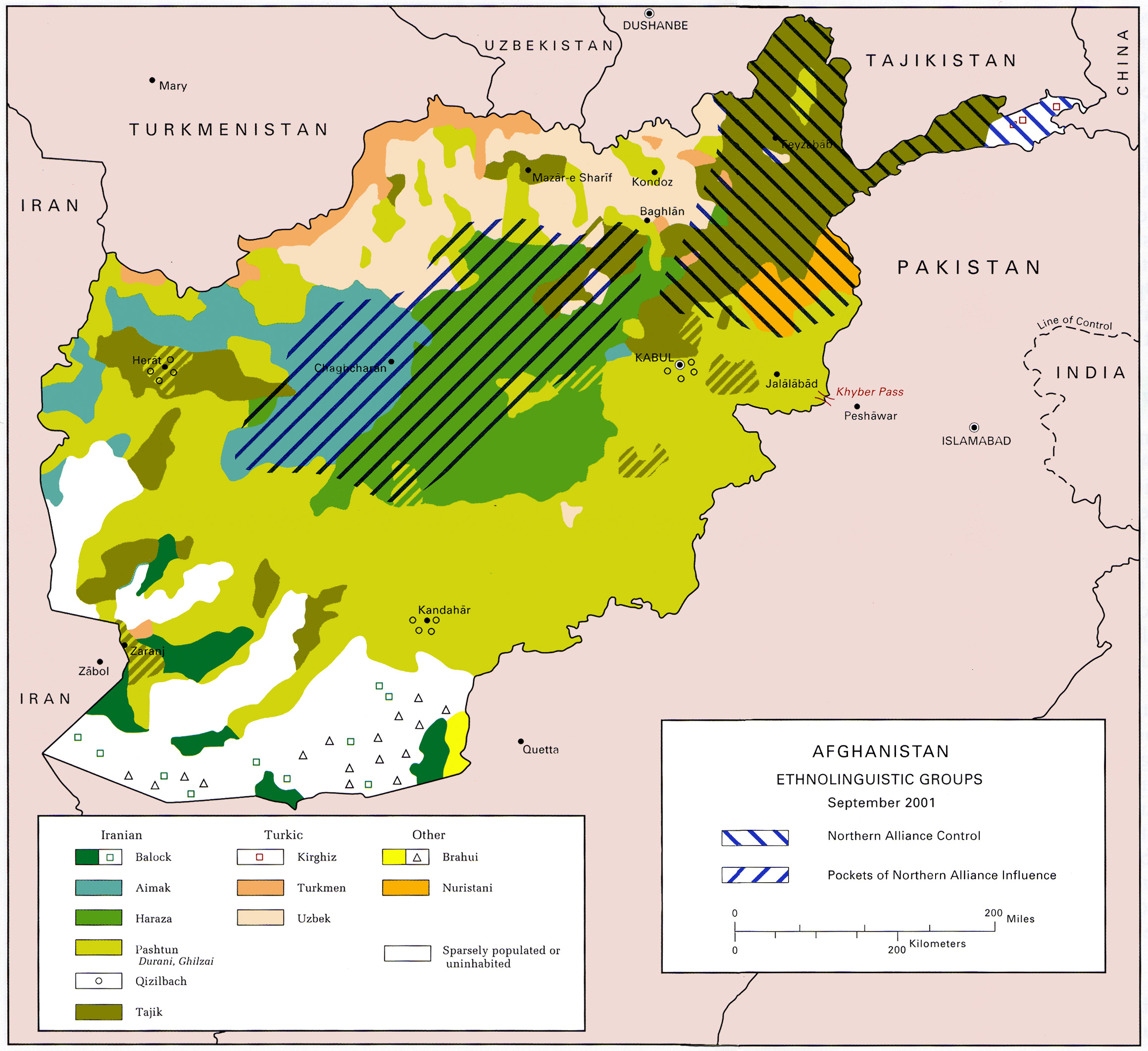
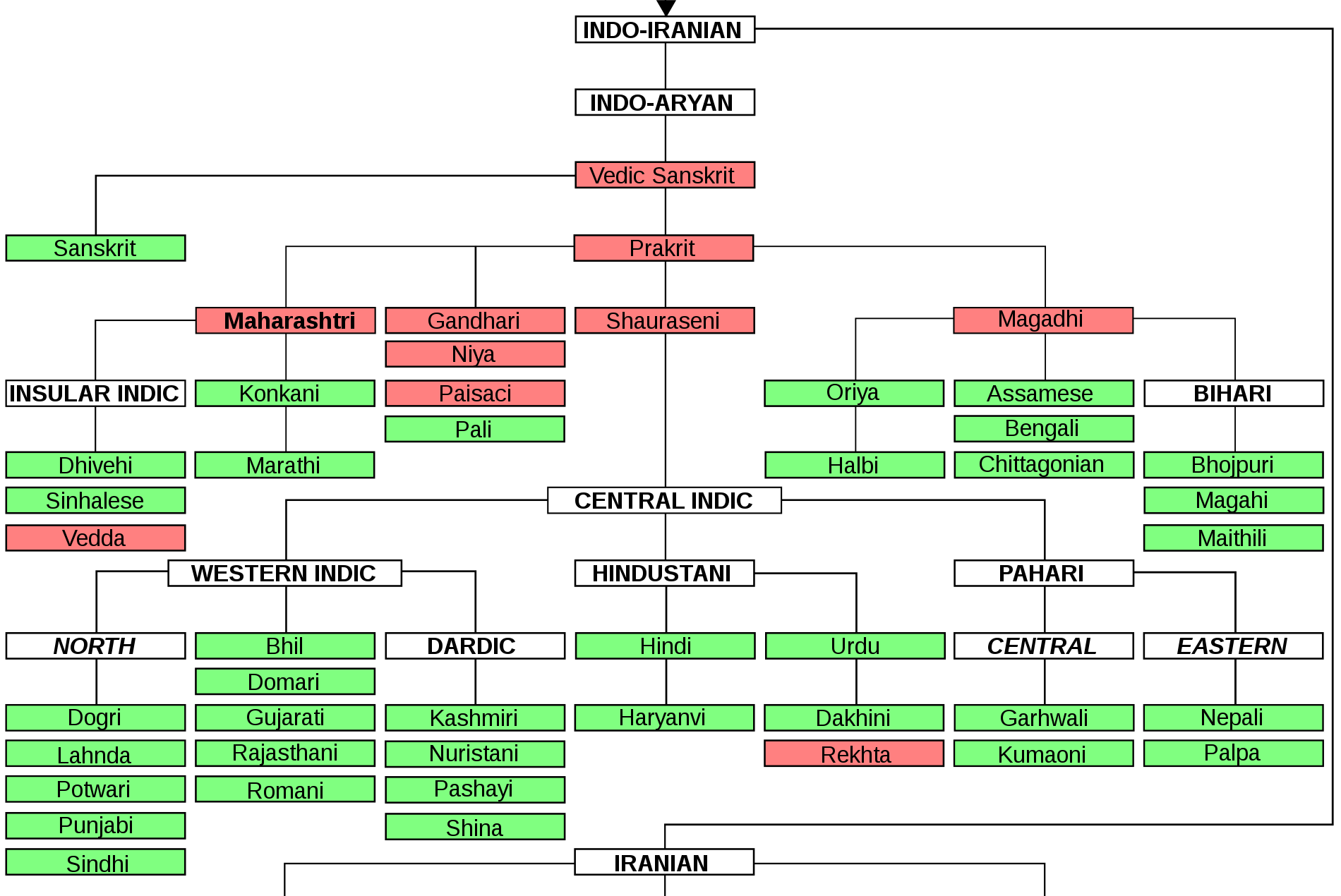
The Nuristani languages are one of the three groups within the Indo-Iranian languages, Indo-Iranian language family, alongside the Indo-Aryan languages, Indo-Aryan and Iranian languages, Iranian languages. They have approximately 214,000 speakers primarily in Nuristan and Kunar Province, Kunar provinces in northeastern Afghanistan and a few adjacent valleys in Khyber Pakhtunkhwa's Chitral District, Pakistan. The region inhabited by the Nuristanis is located in the southern Hindu Kush mountains, and is drained by the Alingar River in the west, the Pech River in the center, and the Landai Sin River, Landai Sin and Kunar River, Kunar rivers in the east. More broadly, the Nuristan region is located at the northern intersection of the Indian subcontinent and the Iranian plateau. The Nuristani languages were not described in literature until the 19th century. The older name for the region was Kafiristan due to the pre-Islamic religious practices of its residents, but this term has been ... [...More Info...] [...Related Items...] OR: [Wikipedia] [Google] [Baidu] |
Nuristan
Nuristan, also spelled as Nurestan or Nooristan (Pashto: ; Katë: ), is one of the 34 provinces of Afghanistan, located in the eastern part of the country. It is divided into seven districts and is Afghanistan's least populous province, with a population of around 167,000. Parun serves as the provincial capital. Nuristan is bordered on the south by Laghman and Kunar provinces, on the north by Badakhshan province, on the west by Panjshir province, and on the east by Pakistan. The origin of the local Nuristani people has been disputed, ranging from being the indigenous inhabitants forced to flee to this region after refusing to surrender to invaders, to being linked to various ancient groups of people and the Turk Shahi kings. Some Nuristanis claim being descendants of the Greek occupying forces of Alexander the Great. It was formerly called Kafiristan () ("Land of the Infidels") until the inhabitants were forcibly converted from an animist religion with elements from I ... [...More Info...] [...Related Items...] OR: [Wikipedia] [Google] [Baidu] |
Indo-Aryan Languages
The Indo-Aryan languages, or sometimes Indic languages, are a branch of the Indo-Iranian languages in the Indo-European languages, Indo-European language family. As of 2024, there are more than 1.5 billion speakers, primarily concentrated east of the Indus river in Bangladesh, Northern India, Eastern Pakistan, Sri Lanka, Maldives and Nepal. Moreover, apart from the Indian subcontinent, large immigrant and expatriate Indo-Aryan–speaking communities live in Northwestern Europe, Western Asia, North America, the Caribbean, Southeast Africa, Polynesia and Australia, along with several million speakers of Romani languages primarily concentrated in Southeast Europe, Southeastern Europe. There are over 200 known Indo-Aryan languages. Modern Indo-Aryan languages descend from Old Indo-Aryan languages such as early Vedic Sanskrit, through Middle Indo-Aryan languages (or Prakrits). The largest such languages in terms of First language, first-speakers are Hindustani language, Hindi–Urdu ... [...More Info...] [...Related Items...] OR: [Wikipedia] [Google] [Baidu] |
Northeastern Katë Dialect
Northeastern Katë is a dialect of the Katë language spoken by the Kata in parts of Afghanistan and Pakistan. It also includes the so-called ''Shekhani'' dialect spoken in Chitral district of Khyber-Pakhtunkhwa province of Pakistan. There are several subdialects spoken in the upper Landai Sin Valley. It is also spoken in Chitral District, in Gobor and the upper Bumboret Valley in Pakistan. Innovations According to Halfmann (2024), the primary innovations of the Northeastern dialect include secondary vowel length from monophthongization of vowel + ''v'' and a progressive suffix ''-t-''. Orthography In August 2022, Pakistani linguist, Rehmat Aziz Chitrali proposed a keyboard to Khowar Academy, Chitral. History Speakers of Eastern Katë dialects migrated from Kamdesh in Nuristan in modern-day Afghanistan to Lutkuh Valley in Chitrali Princely State in British Raj during the 19th century. Most speakers in Pakistan speak either Pashto or Khowar as a second langua ... [...More Info...] [...Related Items...] OR: [Wikipedia] [Google] [Baidu] |
Western Katë Dialect
Western Katë is a dialect of the Katë language spoken by the Kata in parts of Afghanistan. The most used alternative names are ''Kata-vari'' or ''Kati''. Together with the Northeastern dialect, it is spoken by approximately 40,000 people (mostly in Afghanistan, just over 3,700 in Pakistan), and its speakers are Muslim. Literacy rates are low: below 1% for people who have it as a first language, and between 15% and 25% for people who have it as a second language. There are several subdialects spoken in the Ramgal, Kulam, Ktivi and Paruk valleys of Nuristan Nuristan, also spelled as Nurestan or Nooristan (Pashto: ; Katë: ), is one of the 34 provinces of Afghanistan, located in the eastern part of the country. It is divided into seven districts and is Afghanistan's least populous province, with a .... Innovations According to Halfmann (2024), the primary innovations of the Western dialect include loss of nasalization, a progressive suffix ''-n-'', and a past copul ... [...More Info...] [...Related Items...] OR: [Wikipedia] [Google] [Baidu] |
Nuristan Map (Nuristan Kart)
Nuristan, also spelled as Nurestan or Nooristan (Pashto: ; Katë: ), is one of the 34 provinces of Afghanistan, located in the eastern part of the country. It is divided into seven districts and is Afghanistan's least populous province, with a population of around 167,000. Parun serves as the provincial capital. Nuristan is bordered on the south by Laghman and Kunar provinces, on the north by Badakhshan province, on the west by Panjshir province, and on the east by Pakistan. The origin of the local Nuristani people has been disputed, ranging from being the indigenous inhabitants forced to flee to this region after refusing to surrender to invaders, to being linked to various ancient groups of people and the Turk Shahi kings. Some Nuristanis claim being descendants of the Greek occupying forces of Alexander the Great. It was formerly called Kafiristan () ("Land of the Infidels") until the inhabitants were forcibly converted from an animist religion with elements from I ... [...More Info...] [...Related Items...] OR: [Wikipedia] [Google] [Baidu] |
Iranian Plateau
The Iranian plateau or Persian plateau is a geological feature spanning parts of the Caucasus, Central Asia, South Asia, and West Asia. It makes up part of the Eurasian plate, and is wedged between the Arabian plate and the Indian plate. The plateau is situated between the Zagros Mountains to the west, the Caspian Sea and the Köpet Dag to the north, the Armenian Highlands and the Caucasus Mountains to the northwest, the Strait of Hormuz and the Persian Gulf to the south, and the Indian subcontinent to the southeast. As a historical region, it includes Parthia, Media, Persis, and some of the previous territories of Greater Iran."Old Iranian Online" , University of Texas College of Liberal Arts (retrieved 10 February 2007) The Zagros form the plateau's western boundary, and its eastern slopes may also ... [...More Info...] [...Related Items...] OR: [Wikipedia] [Google] [Baidu] |
Indian Subcontinent
The Indian subcontinent is a physiographic region of Asia below the Himalayas which projects into the Indian Ocean between the Bay of Bengal to the east and the Arabian Sea to the west. It is now divided between Bangladesh, India, and Pakistan. (subscription required) Although the terms "Indian subcontinent" and "South Asia" are often also used interchangeably to denote a wider region which includes, in addition, Bhutan, the Maldives, Nepal and Sri Lanka, the "Indian subcontinent" is more of a geophysical term, whereas "South Asia" is more geopolitical. "South Asia" frequently also includes Afghanistan, which is not considered part of the subcontinent even in extended usage.Jim Norwine & Alfonso González, ''The Third World: states of mind and being'', pages 209, Taylor & Francis, 1988, Quote: ""The term "South Asia" also signifies the Indian Subcontinent""Raj S. Bhopal, ''Ethnicity, race, and health in multicultural societies'', pages 33, Oxford University Press, 2007, ; Q ... [...More Info...] [...Related Items...] OR: [Wikipedia] [Google] [Baidu] |
Kunar River
The Chitral River, also known in Afghanistan as the Kunar River, is a long river in northern Pakistan and eastern Afghanistan. It originates from the Chiantar glacier, located at the border of Gilgit Baltistan and Chitral in Pakistan. At Arandu it enters into Afghanistan, where it is called the Kunar River. It later merges with Kabul river in Nangahar Province of Afghanistan. The river system is fed by melting glaciers and snow of the Hindu Kush mountains. The Chitral River serves as a major tributary of the Kabul river, which is in turn a tributary of the Indus River in Pakistan.''The Afghan War, 1838-1842: From the Journal and Correspondence of the Late Major-General Augustus Abbott'', editor Charles Rathbone Low, publisher R. Bentley & Son, 1879Google Books/ref> Origin and course of flow The river rises in the far north glaciated Hindu Kush mountains of Chitral, Pakistan, where it is referred to as Chitral river. Around 60% to 70% of annual discharge of Kunar river o ... [...More Info...] [...Related Items...] OR: [Wikipedia] [Google] [Baidu] |
Landai Sin River
The Landai Sin River ( ''Lanḍai Sīn'', "Short River"), also called the Bashgal River (), is located in eastern Afghanistan. It rises in the Hindu Kush range near the Mandol Pass in the Nuristan Province of Afghanistan, and is fed from glaciers and snow to its north. The Landai Sin is a tributary of Kunar River. The Landai Sin Valley is inhabited by the Kata, Mumo (''Madugal''), Kashtan, and Kom tribes of the Nuristani people. Eastern Kata-vari is the main spoken language in the Landai Sin Valley. The main town on the river is Kamdesh. See also * List of rivers of Afghanistan This is a list of rivers that flow wholly or partly in Afghanistan, arranged geographically by river basin. Flowing into the Arabian Sea *''Indus River (Pakistan)'' **Gomal River ***Kundar River ***Zhob River **Kurram River **Kabul River ... References External links Rivers of Afghanistan Indus basin Landforms of Nuristan Province Border rivers {{Nuristan-geo-stub ... [...More Info...] [...Related Items...] OR: [Wikipedia] [Google] [Baidu] |
Pech River
The Pech River () is located in eastern Afghanistan. Course The Pech River system is fed from glaciers and snow from the Hindu Kush range to its north. The river rises in central Nuristan Province and flows south and southeasterly through the center of Kunar Province, joining the Kunar River (Asmar River, ''Loy Seend'') at the provincial capital of Asadabad. The Kunar is a tributary of the Kabul River, part of the Indus River basin. The river has numerous tributaries forming valleys on both sides. These include the Chapa Dara, Waygal, Korangal Valley (site of the film '' Restrepo''), Watapur, and Sharyak valleys. Culture In the Pech Valley, Pashto and the Askunu languages are spoken. The Safi tribe of Pashtuns is the majority population in the Pech Valley. The river's largest settlement is Nangalam, at the confluence of the Waygal River with the Pech River. Military history There were a series of U.S. military bases along the Pech River Valley in Kunar Province, incl ... [...More Info...] [...Related Items...] OR: [Wikipedia] [Google] [Baidu] |
Alingar River
The Alingar River (also Alingâr) in Laghman Province of Afghanistan is one of the major tributaries of the Kabul River, and part of the Indus River The Indus ( ) is a transboundary river of Asia and a trans-Himalayas, Himalayan river of South Asia, South and Central Asia. The river rises in mountain springs northeast of Mount Kailash in the Western Tibet region of China, flows northw ... basin. It has two sources, the Ramgel and Kulem rivers. It gives its name to Alingar District as well as to Alingar Valley in which that district is located. It also flows through Mihtarlam in Mihtarlam District. See also * References Rivers of Afghanistan Kabul River Landforms of Laghman Province Valleys of Afghanistan Rivers of Pakistan {{Laghman-geo-stub ... [...More Info...] [...Related Items...] OR: [Wikipedia] [Google] [Baidu] |
Khyber Pakhtunkhwa
Khyber Pakhtunkhwa (; ; , ; abbr. KP or KPK), formerly known as the North West Frontier Province (NWFP), is a Administrative units of Pakistan, province of Pakistan. Located in the Northern Pakistan, northwestern region of the country, Khyber Pakhtunkhwa is the fourth largest province of Pakistan by land area and the third-largest province by population. It is bordered by Balochistan, Pakistan, Balochistan to the south; Punjab, Pakistan, Punjab, Islamabad Capital Territory, and Azad Kashmir to the east; and Gilgit-Baltistan to the north and northeast. It shares an Durand Line, international border with Afghanistan to the west. Khyber Pakhtunkhwa has a varied geography of rugged mountain ranges, valleys, rolling foothills, and dense agricultural farms. While it is the third-largest Pakistani province in terms of both its population and Economy of Khyber Pakhtunkhwa, its economy, it is geographically the smallest. Khyber Pakhtunkhwa's share of Pakistan's GDP has historically com ... [...More Info...] [...Related Items...] OR: [Wikipedia] [Google] [Baidu] |


