|
Coppermine Mimbreños
{{disambig ...
Coppermine may refer to: * Coppermine Peninsula, Antarctica * Alanngorsuaq Fjord also known as Coppermine Bay, Greenland * Coppermine Herald, one of the heralds at the Canadian Heraldic Authority * Coppermine expedition (1819–1822), a British overland undertaking to survey and chart the area from Hudson Bay to the north coast of North America, eastwards from the mouth of the Coppermine River. * Coppermine River Group, a sequence of Mesoproterozoic continental flood basalts, Nunavut and the Northwest Territories * Coppermine River, in Nunavut and the Northwest Territories * Kugluktuk, Nunavut, formerly known as Coppermine * Pentium III, a microprocessor code-named "Coppermine" See also * Copper extraction Copper extraction is the multi-stage process of obtaining copper from list of copper ores, its ores. The conversion of copper ores consists of a series of physical, chemical, and electrochemical processes. Methods have evolved and vary with coun ... [...More Info...] [...Related Items...] OR: [Wikipedia] [Google] [Baidu] |
Coppermine Peninsula
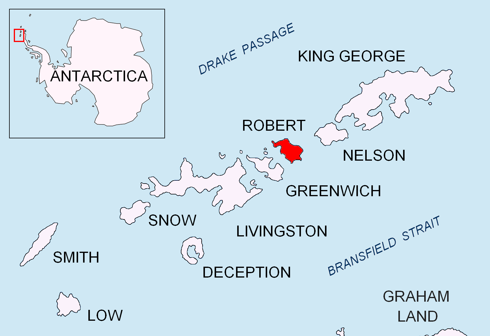
Coppermine Peninsula is the rugged, rocky promontory forming the northwest extremity of Alfatar Peninsula and Robert Island in the South Shetland Islands, Antarctica. It lies between the English Strait to the west and Carlota Cove to the east. It is 1.7 km long, 500 m wide and rising to 105 m. Coppermine Peninsula is linked to Alfatar Peninsula to the southeast by a narrow isthmus bounded by Carlota Cove to the north and the 1 km wide and 460 m indenting ''Coppermine Cove'' () to the south. The feature is named in association with the adjacent Coppermine Cove, a descriptive name given by sealers in about 1821 from the copper-coloured staining of the lavas and tuffs in the area. Antarctic Specially Protected Area The Coppermine Peninsula has a regime of special environmental protection under the Antarctic Treaty System. All land west of a north-south line across the isthmus between Carlota Cove and Coppermine Cove, has been designated an Antarctic Specially Protec ... [...More Info...] [...Related Items...] OR: [Wikipedia] [Google] [Baidu] |
Alanngorsuaq Fjord
Alanngorsuaq Fjord, also known as Coppermine Bay (), is a fjord in the Kujalleq municipality in southern Greenland. At the mouth of the fjord the coastline of southwestern Greenland turns to the east towards Qaqortoq. Geography Alanngorsuaq Fjord opens towards the west a few miles north of Cape Desolation. The Inner Kitsissut islands lie on the southern side of the mouth of the bay. The fjord is long,Norwegian University of Science and Technology with an east-north-east − west-south-west orientation, opening into the . There are several oblong, uninhabited islands in the inner part of the fjord, its mouth widening into a bay at the confluenc ... [...More Info...] [...Related Items...] OR: [Wikipedia] [Google] [Baidu] |
Coppermine Herald
Coppermine Herald of Arms is the title of one of the officers of arms at the Canadian Heraldic Authority in Ottawa. The office was created in 2003 and Coppermine Herald is the assistant artist of the Authority. Like the other heralds at the Authority, the name is derived from the Canadian river. The design of the badge of office of Coppermine Herald of Arms was assigned on 15 June 2005. The ulu in the badge is a traditional Inuit knife that has existed for over 4000 years. It honours the northern people and land. Its copper colour refers to the title Coppermine Herald. Since the creation of the office, it has been held by Catherine Fitzpatrick. See also *Heraldry *Herald A herald, or a herald of arms, is an officer of arms, ranking between pursuivant and king of arms. The title is commonly applied more broadly to all officers of arms. Heralds were originally messengers sent by monarchs or noblemen ... * Royal Heraldry Society of Canada External links Canadian ... [...More Info...] [...Related Items...] OR: [Wikipedia] [Google] [Baidu] |
Coppermine Expedition
The Coppermine expedition of 1819–1822 was a British overland undertaking to survey and chart the area from Hudson Bay to the north coast of North America, eastwards from the mouth of the Coppermine River. The expedition was organised by the Royal Navy as part of its attempt to discover and map the Northwest Passage. It was the first of three Arctic expeditions to be led by John Franklin and also included George Back and John Richardson, both of whom later became notable Arctic explorers in their own right. The expedition was plagued by poor planning, bad luck and unreliable allies. The local fur trading companies and native peoples offered less assistance than expected, and the dysfunctional supply line, coupled with unusually harsh weather and the resulting absence of game, meant the explorers were never far from starvation. Eventually, the party reached the Arctic coast, but only explored roughly before turning back due to the onset of winter and the exhaustion of their ... [...More Info...] [...Related Items...] OR: [Wikipedia] [Google] [Baidu] |
Coppermine River Group
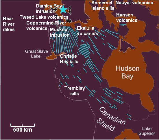
The Coppermine River Group is a sequence of Mesoproterozoic continental flood basalts forming part of the Mackenzie Large Igneous Province in the Northwest Territories and Nunavut, Canada. It is among the largest flood basalt provinces on Earth, covering the area with a volume of approximately . Eruptive history The Coppermine River Group was formed when vast volumes of basaltic lava paved over a large area of the northwestern Canadian Shield about 1,267 million years ago. These basalts form flood basalts that reach thicknesses ranging from to and consists of about 150 lava flows, each about 10–25 m thick. Except for the lowermost flows, which contain evidence of interaction with water, the entire sequence was erupted subaerially. Eruption of plateau lavas near the Coppermine River, built an extensive volcanic plateau A volcanic plateau is a plateau produced by volcanic activity. There are two main types: lava plateaus and pyroclastic plateaus. Lava pla ... [...More Info...] [...Related Items...] OR: [Wikipedia] [Google] [Baidu] |
Coppermine River
The Coppermine River is a river in the North Slave Region, North Slave and Kitikmeot Region, Nunavut, Kitikmeot regions of the Northwest Territories and Nunavut in Canada. It is long. It rises in Lac de Gras, a small lake near Great Slave Lake, and flows generally north to Coronation Gulf, an arm of the Arctic Ocean. The river freezes in winter but may still flow under the ice. The community of Kugluktuk, Nunavut, Kugluktuk (formerly Coppermine) is located at the river's mouth. History The river was named for the copper ores which are located along the river, by Samuel Hearne in 1771. Hearne found only one lump of copper and commercial mining was not considered viable. Bloody Falls, part of the Kugluk/Bloody Falls Territorial Park, is located from Kugluktuk, and was home to the Kogluktogmiut a sub-group of the Copper Inuit. It is the site of the Bloody Falls Massacre, when Matonabbee, Samuel Hearne's guide, and his fellow Chipewyan warriors ambushed and massacred the local In ... [...More Info...] [...Related Items...] OR: [Wikipedia] [Google] [Baidu] |
Kugluktuk
Kugluktuk (, ; Inuktitut syllabics: ; ), known as Coppermine until 1 January 1996, is a hamlet at the mouth of the Coppermine River in the Kitikmeot Region of Nunavut, Canada, on Coronation Gulf, southwest of Victoria Island. It is Nunavut's westernmost community, near the border with the Northwest Territories. The area's traditional language is Inuinnaqtun, which is written in the Latin alphabet, rather than the syllabics of the Inuktitut writing system. Like Cambridge Bay, Bathurst Inlet, and Umingmaktok, syllabics are rarely seen and are used mainly by the Government of Nunavut. History Prior to European contact, Dene travelled to the area and interacted acrimoniously with nearby Thule and Inuit, sometimes ending in deadly raids against each other (see Bloody Falls massacre). In July 1821, the British Coppermine expedition team reached the mouth of the Coppermine River, just next to the present day community of Kugluktuk. Arctic explorers Peter Warren Dease and Tho ... [...More Info...] [...Related Items...] OR: [Wikipedia] [Google] [Baidu] |
Pentium III
The Pentium III (marketed as Intel Pentium III Processor, informally PIII or P3) brand refers to Intel's 32-bit x86 desktop and mobile CPUs based on the sixth-generation P6 (microarchitecture), P6 microarchitecture introduced on February 28, 1999. The brand's initial processors were very similar to the earlier Pentium II-branded processors. The most notable differences were the addition of the Streaming SIMD Extensions (SSE) instruction set (to accelerate floating point and parallel calculations), and the introduction of a controversial serial number embedded in the chip during manufacturing. Even after the release of the Pentium 4 in late 2000, the Pentium III continued to be produced with new models introduced up until early 2003. They were then discontinued in April 2004 for desktop units and May 2007 for mobile units. Processor cores Similarly to the Pentium II it superseded, the Pentium III was also accompanied by the Celeron brand for lower-end versions, and the Xeon for ... [...More Info...] [...Related Items...] OR: [Wikipedia] [Google] [Baidu] |


