|
Boulevard Lake Park
The Current River Greenway is a 263 hectare (650 acre) greenway located in Current River neighbourhood in the north end of Thunder Bay, Ontario along the Current River. Throughout the Greenway is 50 km of public trails that are part of the Thunder Bay Recreational Trails and the Trans Canada Trail system. Five kilometres of paved trail circle Boulevard Lake. Part of the trail system incorporates the Black Bay Bridge, North America's first single spandrel, reinforced concrete bridge, which was built in 1911. The trails around Boulevard Lake are also used for various walking marathons in support of local and national charities. Trails outside of the Boulevard Lake area are not paved. Birch Point Park Birch Point Park is located on Birch Point, a peninsula in that separates Boulevard Lake two portions. The park was dedicated in 2000 as part of the Millennium project. It features a sculpture representing the city's forestry heritage and its designation as the Forest Capital ... [...More Info...] [...Related Items...] OR: [Wikipedia] [Google] [Baidu] |
Thunder Bay
Thunder Bay is a city in and the seat of Thunder Bay District, Ontario, Canada. It is the most populous municipality in Northwestern Ontario and the second most populous (after Greater Sudbury) municipality in Northern Ontario; its population is 108,843 according to the 2021 Canadian Census. Located on Lake Superior, the census metropolitan area of Thunder Bay has a population of 123,258 and consists of the city of Thunder Bay, the municipalities of Oliver Paipoonge and Neebing, Ontario, Neebing, the townships of Shuniah, Conmee, Ontario, Conmee, O'Connor, Ontario, O'Connor, and Gillies, Ontario, Gillies, and the Fort William First Nation. European settlement in the region began in the late 17th century with a French fur trading outpost on the banks of the Kaministiquia River.Bri ... [...More Info...] [...Related Items...] OR: [Wikipedia] [Google] [Baidu] |
Ontario
Ontario ( ; ) is one of the thirteen provinces and territories of Canada.Ontario is located in the geographic eastern half of Canada, but it has historically and politically been considered to be part of Central Canada. Located in Central Canada, it is Canada's most populous province, with 38.3 percent of the country's population, and is the second-largest province by total area (after Quebec). Ontario is Canada's fourth-largest jurisdiction in total area when the territories of the Northwest Territories and Nunavut are included. It is home to the nation's capital city, Ottawa, and the nation's most populous city, Toronto, which is Ontario's provincial capital. Ontario is bordered by the province of Manitoba to the west, Hudson Bay and James Bay to the north, and Quebec to the east and northeast, and to the south by the U.S. states of (from west to east) Minnesota, Michigan, Ohio, Pennsylvania, and New York. Almost all of Ontario's border with the United St ... [...More Info...] [...Related Items...] OR: [Wikipedia] [Google] [Baidu] |
Hectares
The hectare (; SI symbol: ha) is a non-SI metric unit of area equal to a square with 100-metre sides (1 hm2), or 10,000 m2, and is primarily used in the measurement of land. There are 100 hectares in one square kilometre. An acre is about and one hectare contains about . In 1795, when the metric system was introduced, the ''are'' was defined as 100 square metres, or one square decametre, and the hectare ("hecto-" + "are") was thus 100 ''ares'' or km2 (10,000 square metres). When the metric system was further rationalised in 1960, resulting in the International System of Units (), the ''are'' was not included as a recognised unit. The hectare, however, remains as a non-SI unit accepted for use with the SI and whose use is "expected to continue indefinitely". Though the dekare/decare daa (1,000 m2) and are (100 m2) are not officially "accepted for use", they are still used in some contexts. Description The hectare (), although not a unit of SI, i ... [...More Info...] [...Related Items...] OR: [Wikipedia] [Google] [Baidu] |
Acres
The acre is a unit of land area used in the imperial and US customary systems. It is traditionally defined as the area of one chain by one furlong (66 by 660 feet), which is exactly equal to 10 square chains, of a square mile, 4,840 square yards, or 43,560 square feet, and approximately 4,047 m2, or about 40% of a hectare. Based upon the international yard and pound agreement of 1959, an acre may be declared as exactly 4,046.8564224 square metres. The acre is sometimes abbreviated ac but is usually spelled out as the word "acre".National Institute of Standards and Technolog(n.d.) General Tables of Units of Measurement . Traditionally, in the Middle Ages, an acre was conceived of as the area of land that could be ploughed by one man using a team of 8 oxen in one day. The acre is still a statutory measure in the United States. Both the international acre and the US survey acre are in use, but they differ by only four parts per million (see below). The most common use ... [...More Info...] [...Related Items...] OR: [Wikipedia] [Google] [Baidu] |
Boulevard Lake Thunder Bay And Dam
A boulevard is a type of broad avenue planted with rows of trees, or in parts of North America, any urban highway. Boulevards were originally circumferential roads following the line of former city walls. In American usage, boulevards may be wide, multi-lane arterial thoroughfares, often divided with a central median, and perhaps with side-streets along each side designed as slow travel and parking lanes and for bicycle and pedestrian usage, often with an above-average quality of landscaping and scenery. Etymology The word ''boulevard'' is borrowed from French. In French, it originally meant the flat surface of a rampart, and later a promenade taking the place of a demolished fortification. It is a borrowing from the Dutch word ' 'bulwark'. Usage world-wide Asia Cambodia Phnom Penh has numerous boulevards scattered throughout the city. Norodom Boulevard, Monivong Boulevard, Sihanouk Boulevard, and Kampuchea Krom Boulevard are the most famous. India *Bengaluru's Mah ... [...More Info...] [...Related Items...] OR: [Wikipedia] [Google] [Baidu] |
Greenway (landscape)
A greenway is usually a shared-use path along a strip of undeveloped land, in an urban or rural area, set aside for recreational use or environmental protection. Greenways are frequently created out of disused railways, canal towpaths, utility or similar rights of way, or derelict industrial land. Greenways also can also be linear parks, and can serve as wildlife corridors. The path's surface may be paved and often serves multiple users: walkers, runners, bicyclists, skaters and hikers. A characteristic of greenways, as defined by the European Greenways Association, is "ease of passage": that is that they have "either low or zero gradient", so that they can be used by all "types of users, including mobility impaired people". In Southern England, the term also refers to ancient trackways or green lanes, especially those found on chalk downlands, like the Ridgeway. Definition Greenways are vegetated, linear, and multi-purpose. They incorporate a footpath and/or bikewa ... [...More Info...] [...Related Items...] OR: [Wikipedia] [Google] [Baidu] |
Current River, Thunder Bay, Ontario
Current River is a neighbourhood located north east of Port Arthur in the city of Thunder Bay, Ontario. It is separated from the main urban area of Thunder Bay by the Current River Greenway, a large parkland along the river after which the neighbourhood was named. It is home to approximately 4,780 people and has an ageing and declining population.Statistics Canada Census Tract Profile for 0021.00 (CT) Thunder Bay This includes the entire neighbourhood of Current River and the sparsely populated areas north and east of the neighbourhood. Current River is located entirely in Curr ... [...More Info...] [...Related Items...] OR: [Wikipedia] [Google] [Baidu] |
Current River (Ontario)
The Current River is a river in the City of Thunder Bay and Unorganized Thunder Bay District in Thunder Bay District, Northwestern Ontario, Canada. Shows the river's course highlighted on a topographic map. The river is in the Great Lakes Basin and is a tributary of Lake Superior. The river's name comes from the French "''Rivière aux courants''", referring to the river's currents. Course The Current River begins at Current Lake in Unorganized Thunder Bay District and flows northwest, then turns southeast, passing out of Ray Lake over a dam, then under Ontario Highway 527 and reaches Onion Lake. It continues southwest, passes into geographic Gorham Township, flows past the community of Stepstone, and turns southeast before entering the City of Thunder Bay. It takes in the left tributary North Current River, turns south, passes under Ontario Highway 17, then flows through Boulevard Lake and over Boulevard Lake Dam, and flows into Thunder Bay on Lake Superior. History The river' ... [...More Info...] [...Related Items...] OR: [Wikipedia] [Google] [Baidu] |
Trans Canada Trail
The Trans Canada Trail, officially named The Great Trail between September 2016 and June 2021, is a cross- Canada system of greenways, waterways, and roadways that stretches from the Atlantic to the Pacific to the Arctic oceans. The trail extends over ; it is now the longest recreational, multi-use trail network in the world. The idea for the trail began in 1992, shortly after the Canada 125 celebrations. Since then it has been supported by donations from individuals, corporations, foundations, and all levels of government. Trans Canada Trail (TCT) is the name of the non-profit group that raises funds for the continued development of the trail. However, the trail is owned and operated at the local level. On August 26, 2017, TCT celebrated the connection of the trail with numerous events held throughout Canada. TCT has said it now plans to make the trail more accessible, replace interim roadways with off-road greenways, add new spurs and loops to the trail, and fund emergency re ... [...More Info...] [...Related Items...] OR: [Wikipedia] [Google] [Baidu] |
Spandrel
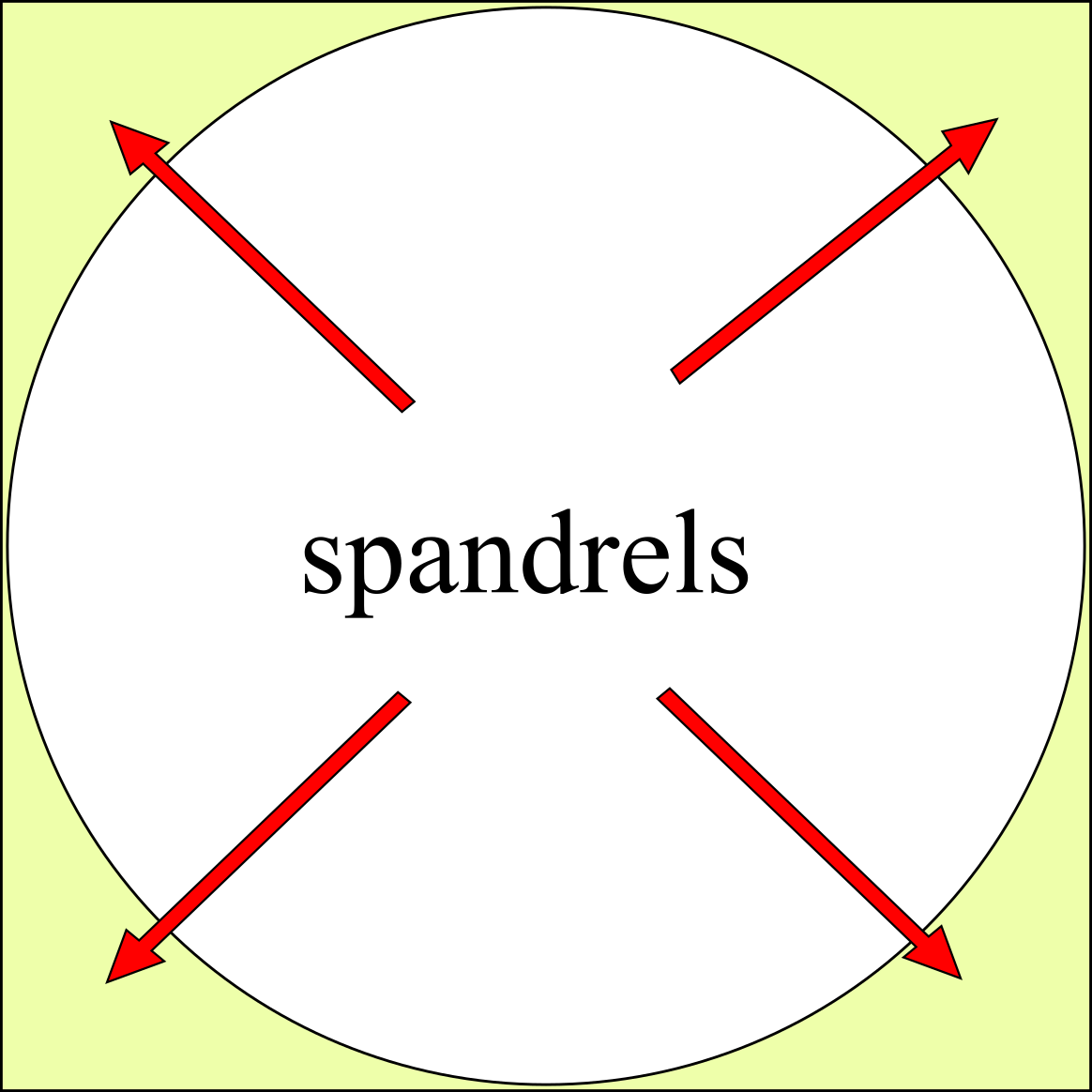
A spandrel is a roughly triangular space, usually found in pairs, between the top of an arch and a rectangular frame; between the tops of two adjacent arches or one of the four spaces between a circle within a square. They are frequently filled with decorative elements. Meaning There are four or five accepted and cognate meanings of the term ''spandrel'' in architectural and art history, mostly relating to the space between a curved figure and a rectangular boundary – such as the space between the curve of an arch and a rectilinear bounding moulding, or the wallspace bounded by adjacent arches in an arcade and the stringcourse or moulding above them, or the space between the central medallion of a carpet and its rectangular corners, or the space between the circular face of a clock and the corners of the square revealed by its hood. Also included is the space under a flight of stairs, if it is not occupied by another flight of stairs. In a building with more than one floor, ... [...More Info...] [...Related Items...] OR: [Wikipedia] [Google] [Baidu] |
Reinforced Concrete
Reinforced concrete (RC), also called reinforced cement concrete (RCC) and ferroconcrete, is a composite material in which concrete's relatively low ultimate tensile strength, tensile strength and ductility are compensated for by the inclusion of reinforcement having higher tensile strength or ductility. The reinforcement is usually, though not necessarily, steel bars (rebar) and is usually embedded passively in the concrete before the concrete sets. However, Prestressed_concrete#Post-tensioned_concrete, post-tensioning is also employed as a technique to reinforce the concrete. In terms of volume used annually, it is one of the most common engineering materials. In corrosion engineering terms, when designed correctly, the alkalinity of the concrete protects the steel rebar from corrosion. Description Reinforcing schemes are generally designed to resist Tension (physics), tensile Stress (mechanics), stresses in particular regions of the concrete that might cause unacceptable frac ... [...More Info...] [...Related Items...] OR: [Wikipedia] [Google] [Baidu] |
Walking Marathon
A walkathon (walk-a-thon), walking marathon or sponsored walk is a type of community or school fundraiser in which participants raise money by collecting donations or pledges for walking a predetermined distance or course. They are similar in format to other physical activity based fundraising events such as marathons and cycling races, but are usually non-competitive and lower intensity. The low intensity model is ideal for mobilizing broad-based community support, and as a result Walkathons usually target participants from a wide range of ages and economic backgrounds. Walkathons are popular fundraisers for issues that affect large sections of the population. Most commonly, Walkathons focus on fighting or curing pervasive diseases or ailments such as AIDS, Cancer, Diabetes, Lupus, and Arthritis, and participation is also often promoted as a symbol of empowerment, remembrance, or awareness of sufferers and their relations. Walkathons are also popular for elementary schools becau ... [...More Info...] [...Related Items...] OR: [Wikipedia] [Google] [Baidu] |


