|
Bosnian Krajina
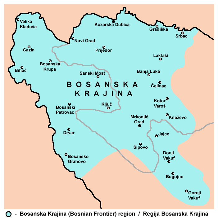
Bosanska Krajina ( sr-cyrl, Босанска Крајина, ) is a geographical region, a subregion of Bosnia, in western Bosnia and Herzegovina. It is enclosed by a number of rivers, namely the Sava (north), Glina (northwest), Vrbanja and Vrbas (east and southeast, respectively). The region is also a historic, economic and cultural entity of Bosnia and Herzegovina, famous for its natural beauties and wildlife diversity. The largest city, and its historical center is Banja Luka. Other cities and towns include Bihać, Bosanska Krupa, Bosanski Petrovac, Bosansko Grahovo, Bužim, Cazin, Drvar, Gradiška, Ključ, Kostajnica, Kozarska Dubica, Laktaši, Mrkonjić Grad, Novi Grad, Prijedor, Sanski Most, Šipovo, Velika Kladuša. Bosanska Krajina is not a formal entity within the structure of Bosnia and Herzegovina; however it has a significant cultural and historical identity that was formed through several historic and economic events. The territory of Bosanska Krajina is current ... [...More Info...] [...Related Items...] OR: [Wikipedia] [Google] [Baidu] |
Kostajnica, Bosnia And Herzegovina
Kostajnica ( sr-cyr, Костајница) is a town and municipality located in northern Republika Srpska, an entity of Bosnia and Herzegovina.the official web site of the municipality Kostajnica/Костајница. It is situated in the part of the Кrajina region.official name of region As of 2013, it had a population of 5,977 inhabitants, while the town of Kostajnica has a population of 4,047 inhabitants. The municipality was created from part of the pre-war municipality of [...More Info...] [...Related Items...] OR: [Wikipedia] [Google] [Baidu] |
Donji Kraji
Donji Kraji or Donji Krajevi (''Lower Regions'' or ''Lower Ends'', la, Partes inferiores, italic=yes, ), was a small medieval ''zemlja'' (county, župa) in today's northwestern Bosnia and Herzegovina, mostly expanding within the territory of today's Bosanska Krajina. Name and geography At first, Donji Kraji referred to a region around Ključ on the Sana. Marko Vego derives the name of Donji Kraji from the name of Roman province Lower Pannonia, or later Lower Slavonia, while Pavao Anđelić deduces that the name Donji Kraji (Lower Ends) "also has a certain relation to the rest of (highland) Bosnia", where the terms "Lower" and "End" refers to a border area that is below from the geographical point of view, and in terms of altitude and terrain configuration, in relation to the rest of Bosnia. Jelena Mrgić reject existence of "Donji Kraji Slavonije" altogether, and reject previous etymological discussions among historians, such as Klajić, Jiriček and even Vego, and derives the ... [...More Info...] [...Related Items...] OR: [Wikipedia] [Google] [Baidu] |
Medieval Bosnia
This is the history of Bosnia and Herzegovina in the Middle Ages, between the ancient and Roman period and the Ottoman period. Early Middle Ages The western Balkans had been reconquered from "barbarians" by Byzantine Emperor Justinian (r. 527–565). Sclaveni (Slavs) raided the Western Balkans, including Bosnia, in the 6th and 7th century. According to ''De Administrando Imperio'' written in 10th century, these were followed by Croats and Serbs who arrived in the late 620s and early 630s, the Croats invited by Emperor Heraclius to fend off an invasion by the Pannonian Avars, and both had by this time settled West and East of Bosnia. Croats "settled in area roughly corresponding to modern Croatia, and probably also including most of Bosnia proper, apart from the eastern strip of the Drina valley" while Serbs "corresponding to modern south-western Serbia (later known as Raška), and gradually extended their rule into the territories of Duklja and Hum". Early medieval polity ... [...More Info...] [...Related Items...] OR: [Wikipedia] [Google] [Baidu] |
Federation Of Bosnia And Herzegovina
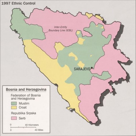
The Federation of Bosnia and Herzegovina is one of the two entities within the State of Bosnia and Herzegovina, the other being Republika Srpska. The Federation of Bosnia and Herzegovina consists of 10 autonomous cantons with their own governments and legislatures. The Federation was created by the 1994 Washington Agreement, which ended the Croat–Bosniak War within the Bosnian War, and established a constituent assembly that continued its work until October 1996. The Federation has a capital, government, president, parliament, customs and police departments and two postal systems. It occupies about half of the land of Bosnia and Herzegovina. From 1996 until 2005 it had its own army, the Army of the Federation of Bosnia and Herzegovina, later merged in the Armed Forces of Bosnia and Herzegovina. The capital and largest city is Sarajevo with 275,524 inhabitants. History The basis for the creation of the Federation of Bosnia and Herzegovina were laid down by th ... [...More Info...] [...Related Items...] OR: [Wikipedia] [Google] [Baidu] |
Republika Srpska
Republika Srpska ( sr-Cyrl, Република Српска, lit=Serb Republic, also known as Republic of Srpska, ) is one of the two entities of Bosnia and Herzegovina, the other being the Federation of Bosnia and Herzegovina. It is located in the north and east of the country. Its largest city and administrative centre is Banja Luka, lying on the Vrbas river. Republika Srpska was formed in 1992 at the outset of the Bosnian War with the stated intent to safeguard the interests of the Serbs of Bosnia and Herzegovina. The war saw the expulsion of the vast majority of Croats and Bosniaks from the territory claimed by Republika Srpska and an inflow of Serbs expelled from Federation of Bosnia and Herzegovina. Following the Dayton Agreement of 1995, Republika Srpska achieved international recognition as an entity within Bosnia and Herzegovina. Today most of Bosnia and Herzegovina's Serb population lives in Republika Srpska. Republika Srpska is a parliamentary-st ... [...More Info...] [...Related Items...] OR: [Wikipedia] [Google] [Baidu] |
Velika Kladuša
Velika Kladuša ( sr-cyrl, Велика Кладуша, ; lit. "Great Kladuša") is a town and municipality located in Una-Sana Canton of the Federation of Bosnia and Herzegovina, an entity of Bosnia and Herzegovina. It is situated in the far northwest of Bosnia and Herzegovina, located near the border with Croatia. As of 2013, it has a population of 40,419 inhabitants. History Velika Kladuša was first mentioned by name on October 30, 1280 (date on its shield) by the name ''Cladosa''. During the era of Byzantine Empire it is assumed that the population of the town started to slowly grow. Towards the end of the 13th century up to 1464, Velika Kladuša was controlled by Croatian noble families of Babonić, Frankopan, Šubić and Tuz de Lak. Around 1464 the Ottoman Empire was expanding towards this region. It was raided in 1558. The town was finally captured in 1633 by Ottomans. Velika Kladuša would later become the center of Ottoman expansion into neighboring Croatia as wel ... [...More Info...] [...Related Items...] OR: [Wikipedia] [Google] [Baidu] |
Šipovo
Šipovo ( sr-cyrl, Шипово) is a town and municipality located in Republika Srpska, an entity of Bosnia and Herzegovina. It is situated in the southern part of the Bosanska Krajina region. As of 2013, it has a population of 10,293 inhabitants, while the town of Šipovo has a population of 4,052 inhabitants. The municipality covers an area of , much of which is forested. History The Glogovac monastery of the Serbian Orthodox Church is near the town Geography It is located between municipalities of Mrkonjić Grad in the west, Jezero in the north, Jajce and Donji Vakuf in the east, and Kupres (Republike Srpske) and Glamoč in the south. In the broader geographical sense, the town of Šipovo is located at 44 17’ north and 170 06’ east, in the zone of temperately continental climate. In the narrower geographical sense, Šipovo is located in south-eastern part of Republika Srpska, with the total area of , and with population of 11,000. The population consists of 95% ... [...More Info...] [...Related Items...] OR: [Wikipedia] [Google] [Baidu] |
Sanski Most
Sanski Most ( sr-cyrl, Сански Мост, ) is a town and municipality located in the Una-Sana Canton of the Federation of Bosnia and Herzegovina, an entity of Bosnia and Herzegovina. It is situated on the banks of the Sana River in northwestern Bosnia and Herzegovina, in the region of Bosanska Krajina, between Prijedor and Ključ. As of 2013, it has a population of 41,475 inhabitants. Geography It is located on the Sana River in Bosanska Krajina, between Prijedor and Ključ. Administratively it is part of the Una-Sana Canton of the Federation of Bosnia and Herzegovina. The Town sits on Nine Rivers, the Nine Rivers are : Sana, Dabar, Zdena, Bliha, Majdanska Rijeka, Japra, Sasinka and Kozica History In 1878 the little town (''varošica'') of Sanski Most was described as Muslim by Croatian historian Vjekoslav Klaić. From 1929 to 1941, Sanski Most was part of the Vrbas Banovina of the Kingdom of Yugoslavia. During World War II it was part of the Axis Independent State of ... [...More Info...] [...Related Items...] OR: [Wikipedia] [Google] [Baidu] |
Prijedor
Prijedor ( sr-cyrl, Приједор, ) is a city and municipality located in the Republika Srpska entity of Bosnia and Herzegovina. As of 2013, it has a population of 89,397 inhabitants within its administrative limits. Prijedor is situated in the north-western part of the Bosanska Krajina geographical region. Prijedor is known for its mixed religious heritage comprising Eastern Orthodox Christianity, Roman Catholicism and Islam. Historic buildings from the Ottoman and Austrian-Hungarian periods are a feature of the urban landscape. The city underwent extensive renovation between 2006–2009. Geography The town of Prijedor, within the municipality of Prijedor, is located in the north-western part of Bosnia and Herzegovina, on the banks of the Sana and Gomjenica rivers, and at the south-western hills of the Kozara mountain. The area of the municipality is . The town is situated at 44°58'39" N and 16°42'29" E, at an altitude of above sea level. It is traditionally a part ... [...More Info...] [...Related Items...] OR: [Wikipedia] [Google] [Baidu] |
Novi Grad, Bosnia And Herzegovina
Novi Grad (Serbian Cyrillic: ), formerly Bosanski Novi ( sr-cyrl, Босански Нови), is a town and municipality in Bosnia and Herzegovina. Administratively, it is located in the Republika Srpska entity. Situated in the far northwest of the country, it lies across the Una from the Croatian town of Dvor. , the town has a population of 11,063 while its municipality comprises a total of 27,115 inhabitants. Known for its scenic quay, Novi Grad lies at the confluence of the Una and Sana rivers. Geography Novi Grad is located on the right bank of the Una and both banks of the Sana, between two geographic zones: the slopes of the mountains of Grmeč and Kozara, and the alluvial land surrounding the town's two rivers. The town itself is located above sea level, at nearly 45°N; the climate is temperate-continental. Its governed municipality covers an area of . History The town was first mentioned in 1280 under the Latin name ''Castrum Novum'' which, literally translated, me ... [...More Info...] [...Related Items...] OR: [Wikipedia] [Google] [Baidu] |


