|
Borkou (region Of Chad)
The Borkou region ( ar, بركو) is a region of Chad which was created in 2008 from the Borkou department of the former Borkou-Ennedi-Tibesti region. Its capital is Faya-Largeau. Geography Borkou is located in the Sahara Desert, and contains parts of the Tibesti Mountains in its north. The highest point in Chad, Emi Koussi, is located in Borkou. The Bodélé Depression lies in the south-central portion of the region. The region borders Libya to the north, Ennedi-Ouest Region to the east, Wadi Fira Region, Batha Region, Bahr el Gazel Region and Kanem Region to the south, and Niger and Tibesti Region the west. The region's northern border lies within the Aouzou Strip, historically a point of dispute between Chad and Libya.Geoffrey Leslie Simons, ''Libya and the West: from independence to Lockerbie'', Centre for Libyan Studies (Oxford, England). Pg. 57 Settlements Faya-Largeau is the regional capital; other major settlements include Gouro, Kirdimi, Koro Toro and Yarda. Demog ... [...More Info...] [...Related Items...] OR: [Wikipedia] [Google] [Baidu] |
Regions Of Chad
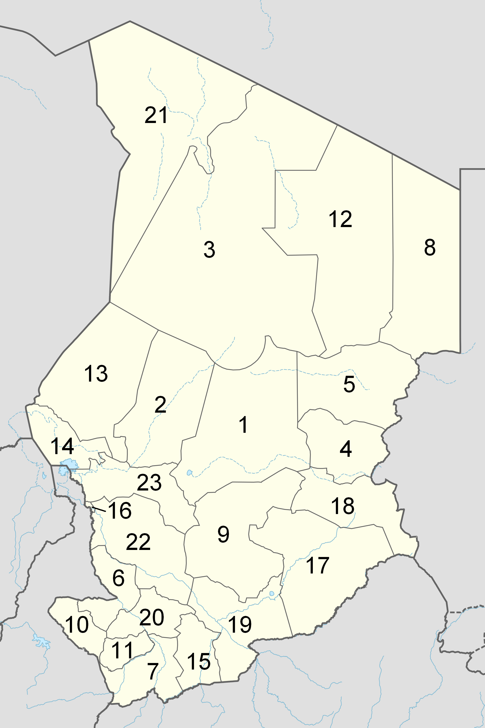
The Republic of Chad is made up of twenty-three regions. Chad was divided into regions in 2002. It was previously divided into prefectures, and then departments. Current regions This is a list of the regions of Chad since 2012, with population figures from the 2009 census. History From independence in 1960 until 1999 it was divided into 14 ''préfectures''. These were replaced in 1999 by 28 ''départements''. The country was reorganized again in 2002 to produce 18 ''régions''. In 2008, a further four ''régions'' were created, increasing the number to 22. Ennedi Region was split into Ennedi-Est and Ennedi-Ouest in 2012, producing the current 23 regions. Regions (2008–2012) Regions (2002–2008) (1) created in 2004 Regions created in 2008 On February 19, 2008, four new regions were created: * Former Borkou-Ennedi-Tibesti Region divided into: ** Borkou Region, from Borkou-Ennedi-Tibesti's former Borkou Department ** Ennedi Region, from Borkou-Ennedi-Tib ... [...More Info...] [...Related Items...] OR: [Wikipedia] [Google] [Baidu] |
Batha Region
Batha ( ar, البطحة) is one of the 23 regions of Chad, located in the centre of the country. It is composed of what was formerly Batha Prefecture with some slight boundary adjustments. The capital of the region is Ati. Geography The region borders Borkou Region to the north, Wadi Fira Region and Ouaddaï Region to the east, Sila Region to the south-east, Guéra Region to the south, Hadjer-Lamis Region to the south-west, and Bahr el Gazel Region to the west. The terrain is generally savannah grassland, merging into the Sahara Desert in the sparsely populated north of the region. Lake Fitri is located in the south-west of the region. Settlements Ati is the capital of the region; other major settlements include Am Sack, Assinet, Djédaa, Haraze Djombo Kibit, Hidjelidjé, Oum Hadjer and Yao. Demographics As per the Chadian census of 2009, the population of the region was 527,031, 51.9% female. The average size of household as of 2009 is 5.1 in rural households and 5.4 ... [...More Info...] [...Related Items...] OR: [Wikipedia] [Google] [Baidu] |
Toubou People
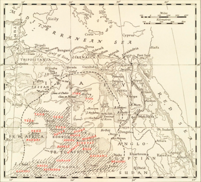
The Toubou or Tubu (from Old Tebu, meaning "rock people") are an ethnic group native to the Tibesti Mountains that inhabit the central Sahara in northern Chad, southern Libya and northeastern Niger. They live either as herders and nomads or as farmers near oases. Their society is clan-based, with each clan having certain oases, pastures and wells. The Toubou are generally divided into two closely related groups: the Teda (or Téda, Toda) and the Dazagara (or Dazzaga, Dazagada, Daza). They are believed to share a common origin and speak the Tebu languages, which are from the Saharan branch of the Nilo-Saharan language family. Tebu is divided further into two closely related languages, called '' Tedaga'' (Téda Toubou) and '' Dazaga'' (Dazaga Gouran). Of the two groups, the Daza, found to the south of the Teda, are more numerous. The Toubou people are also referred to as the Tabu, Tebu, Tebou, Tibu, Tibbu, Toda, Todga, Todaga, Tubu, Tuda, Tudaga, or Gorane people. The Daza ... [...More Info...] [...Related Items...] OR: [Wikipedia] [Google] [Baidu] |
Tedaga
The Teda language, also known as Tedaga, is a Nilo-Saharan language spoken by the Teda, a northern subgroup of the Toubou people that inhabits southern Libya, northern Chad and eastern Niger ) , official_languages = , languages_type = National languagesDaza, the northern Teda dialect constitutes one of the two varieties of Tebu. However, Teda is also sometimes used for Tebu in general. References * Barth, Heinrich 1854. Schreiben an Prof. Lepsius über die Beziehung der Kanori- und Teda-Sprachen. ''Zeitschrift fur Erdkunde'', ...[...More Info...] [...Related Items...] OR: [Wikipedia] [Google] [Baidu] |
Dazaga
Daza (also known as Dazaga) is a Nilo-Saharan language spoken by the Daza people inhabiting northern Chad. The Daza are also known as the Gouran (Gorane) in Chad. Dazaga is spoken by around 380,000 people, primarily in the Djurab Desert region and the Borkou region, locally called Haya or Faya-Largeau northern-central Chad, the capital of the Dazaga people. Dazaga is spoken in the Tibesti Mountains of Chad (330,000 speakers), in eastern Niger near N'guigmi and to the north (50,000 speakers). It is also spoken to a smaller extent in Libya and in Sudan, where there is a community of 3,000 speakers in the city of Omdurman. There's also a small diaspora community working in Jeddah, Saudi Arabia. The two primary dialects of the Dazaga language are Daza and Kara, but there are several other mutually intelligible dialects, including Kaga, Kanobo, Taruge and Azza. It is closely related to the Tedaga language, spoken by the Teda, the other out of the two Toubou people groups, who ... [...More Info...] [...Related Items...] OR: [Wikipedia] [Google] [Baidu] |
UNOCHA
The United Nations Office for the Coordination of Humanitarian Affairs (OCHA) is a United Nations (UN) body established in December 1991 by the General Assembly to strengthen the international response to complex emergencies and natural disasters. It is the successor to the Office of the United Nations Disaster Relief Coordinator (UNDRO). The Department of Humanitarian Affairs (DHA) was established shortly thereafter by the Secretary-General, but in 1998 was merged into OCHA, which became the UN's main focal point on major disasters. OCHA's mandate was subsequently broadened to include coordinating humanitarian response, policy development and humanitarian advocacy. Its activities include organizing and monitoring humanitarian funding, advocacy, policy-making, and information exchange to facilitate rapid-response teams for emergency relief. OCHA is led by the Under-Secretary-General for Humanitarian Affairs and Emergency Relief Coordinator (USG/ERC), appointed for a five-ye ... [...More Info...] [...Related Items...] OR: [Wikipedia] [Google] [Baidu] |
Koro Toro
Koro Toro is a settlement in southern Borkou-Ennedi-Tibesti Region in Chad. It hosts the Koro Toro Airport and a "notorious" maximum security desert prison used by the Chadian government to detain captured fighters of Boko Haram and Chadian rebel groups. According to the Chadian opposition, Koro Toro is factually a penal colony. It is also known as anthropological and archaeological site, as the fossil hominin ''Australopithecus bahrelghazali ''Australopithecus bahrelghazali'' is an extinct species of australopithecine discovered in 1995 at Koro Toro, Bahr el Gazel, Chad, existing around 3.5 million years ago in the Pliocene. It is the first and only australopithecine known from Ce ...'' was discovered at Koro Toro in January 1995. References Works cited * Pliocene paleontological sites of Africa Prehistoric Chad Paleoanthropological sites {{Chad-geo-stub ... [...More Info...] [...Related Items...] OR: [Wikipedia] [Google] [Baidu] |
Gouro, Chad
Dourgoulanga is a sub-prefecture of Ennedi Region Ennedi Region was a former region of Chad. It was created in 2008 from the Ennedi Est Department and Ennedi Ouest Department of the former Borkou-Ennedi-Tibesti Region. The capital of the Ennedi region was Fada. In 2012 it was split into two ... in Chad. References Populated places in Chad {{Chad-geo-stub ... [...More Info...] [...Related Items...] OR: [Wikipedia] [Google] [Baidu] |
Aouzou Strip
The Aouzou Strip (; ar, قطاع أوزو, Qiṭāʿ Awzū, french: Bande d'Aozou) is a strip of land in northern Chad that lies along the border with Libya, extending south to a depth of about 100 kilometers into Chad's Borkou, Ennedi Ouest, Ennedi Est, and Tibesti Regions for an area of 114,000 km2. It is named after the small town and oasis of Aouzou. The region played a significant role in the Chadian–Libyan War. Inclusion in Italian Libya The Aouzou strip was defined for the first time in the discussions between France and Italy after World War I, in relation to an award to Italy for the victory in that war. At the Paris Peace Conference, 1919, the Kingdom of Italy did not receive any of the German colonies, but instead was given the Oltre Giuba from the United Kingdom, and France agreed to give some Saharan territories to Italian Libya. After many discussions during the 1920s, in 1935 the Franco-Italian Agreement was signed between Benito Mussolini and ... [...More Info...] [...Related Items...] OR: [Wikipedia] [Google] [Baidu] |
Tibesti Region
Tibesti Region ( ar, مقاطعة تيبستي) is a region of Chad, located in far northwest of the country. Its capital is Bardaï. It was created in 2008 when the former Borkou-Ennedi-Tibesti Region was split into three, with the Tibesti Department becoming the Tibesti Region. The region is named for the Tibesti Mountains, one of the most prominent mountain chains in the Sahara Desert. Tibesti is the least populated region of Chad, and also has the lowest GDP in the country. History Ancient The rock paintings and engravings in Tibesti bear witness to an ancient civilization from 25,000 B.C. There are rock engravings in the area of Zouar, featuring, among others, cows eating fresh grass, attesting to the wet past of the Sahara. The area has historically been mainly inhabited by the Toubou people. Age of Colonisation In 1869 Gustav Nachtigal was sent by German Chancellor Otto von Bismarck to contact the Sultan of Bornu, and was the first European to travel the Tibest ... [...More Info...] [...Related Items...] OR: [Wikipedia] [Google] [Baidu] |


