|
Basildon Urban District
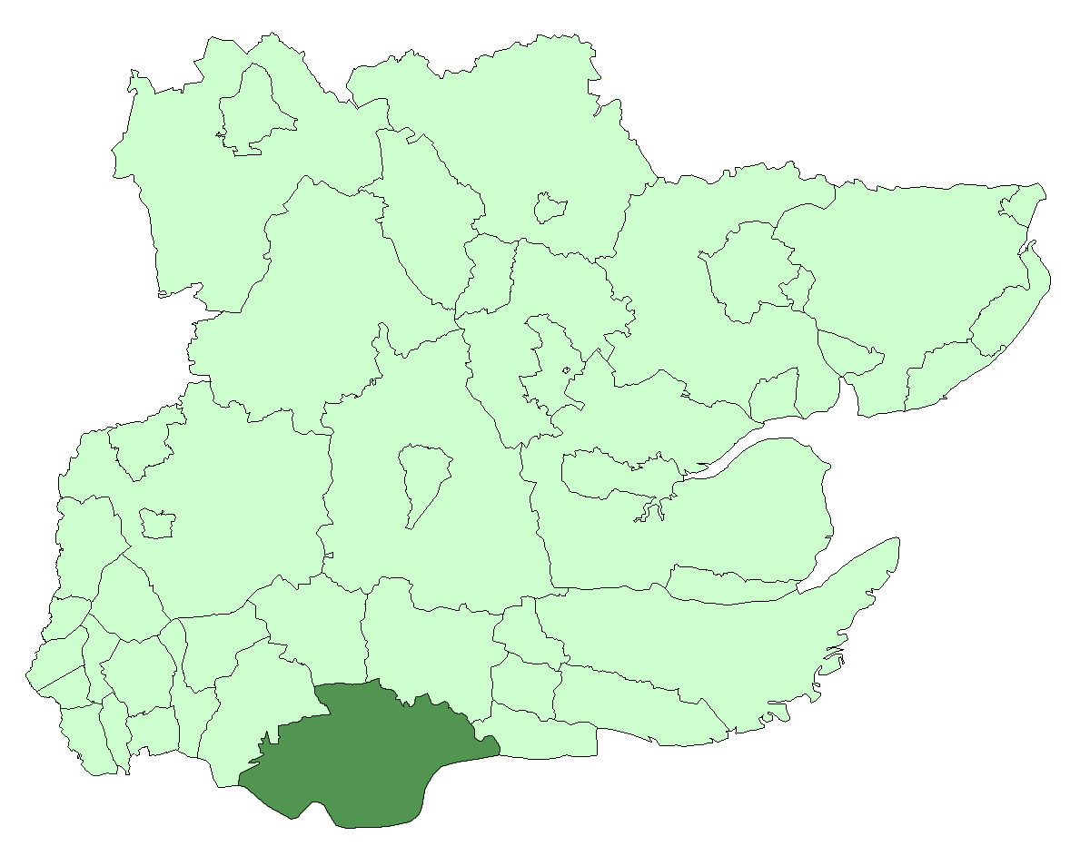
Basildon Urban District (from 1934 to 1955 Billericay Urban District) was a local government district in south Essex, England from 1934 to 1974. The district was created in 1934 from the following parishes (all from Billericay Rural District): *Basildon *Bowers Gifford *Great Burstead *Laindon * Lee Chapel * Little Burstead (until 1938, to Thurrock Urban District) * Nevendon * North Benfleet *Pitsea * Vange *Wickford It also gained from Chelmsford Rural District and from Orsett Rural District. In 1937 all the parishes were abolished and used to create a Billericay Billericay ( ) is a town and civil parish in the Borough of Basildon, Essex, England. It lies within the London Basin and constitutes a commuter town east of Central London. The town has three secondary schools and a variety of open spaces. It i ... parish which occupied the same area as the district. In 1955 the district was renamed Basildon, still consisting of the Billericay parish. [...More Info...] [...Related Items...] OR: [Wikipedia] [Google] [Baidu] |
Urban District (Great Britain And Ireland)
In England and Wales, Northern Ireland, and the Republic of Ireland, an urban district was a type of local government district that covered an urbanised area. Urban districts had an elected urban district council (UDC), which shared local government responsibilities with a county council. England and Wales In England and Wales, urban districts and rural districts were created in 1894 (by the Local Government Act 1894) as subdivisions of administrative counties. They replaced the earlier system of urban and rural sanitary districts (based on poor law unions) the functions of which were taken over by the district councils. The district councils also had wider powers over local matters such as parks, cemeteries and local planning. An urban district usually contained a single parish, while a rural district might contain many. Urban districts were considered to have more problems with public health than rural areas, and so urban district councils had more funding and greater p ... [...More Info...] [...Related Items...] OR: [Wikipedia] [Google] [Baidu] |
Borough Of Basildon
The Borough of Basildon is a local government district in south Essex in the East of England, centred on the town of Basildon. It was formed as the Basildon District on 1 April 1974 from the former area of Basildon Urban District and the part of Thurrock Urban District that was within the Basildon New Town. The population of the district as of 2010 is about 172,000. The local authority is Basildon Borough Council. The council made an application for borough status in February 2010 and this was given approval that year, with Mo Larkin becoming the first mayor in October. History The Basildon District was created on 1 April 1974 as part of the local government reorganisation of the Local Government Act 1972. It comprised the former area of the Basildon Urban District and the part of Basildon New Town that had been in Thurrock Urban District. Governance Elections to Basildon Borough Council are held in three out of every four years, with one third of the 42 seats on the c ... [...More Info...] [...Related Items...] OR: [Wikipedia] [Google] [Baidu] |
Districts Of England Abolished By The Local Government Act 1972
A district is a type of administrative division that, in some countries, is managed by the local government. Across the world, areas known as "districts" vary greatly in size, spanning regions or counties, several municipalities, subdivisions of municipalities, school district, or political district. By country/region Afghanistan In Afghanistan, a district ( Persian ps, ولسوالۍ ) is a subdivision of a province. There are almost 400 districts in the country. Australia Electoral districts are used in state elections. Districts were also used in several states as cadastral units for land titles. Some were used as squatting districts. New South Wales had several different types of districts used in the 21st century. Austria In Austria, the word is used with different meanings in three different contexts: * Some of the tasks of the administrative branch of the national and regional governments are fulfilled by the 95 district administrative offices (). The area a d ... [...More Info...] [...Related Items...] OR: [Wikipedia] [Google] [Baidu] |
Billericay
Billericay ( ) is a town and civil parish in the Borough of Basildon, Essex, England. It lies within the London Basin and constitutes a commuter town east of Central London. The town has three secondary schools and a variety of open spaces. It is thought to have been occupied since the Bronze Age. Toponym The origin of the name Billericay is unclear. It was first recorded as "Byllyrica" in 1291. The urban settlement, which was within the manor and parish of Great Burstead, was one of many founded in the late 13th century in an already densely populated rural landscape. Several suggestions for the origin of the place name include: * ''Villa Erica'' (Heather Villa), suggesting a Romano-British origin. * ''bellerīca'', a medieval Latin word meaning 'dyehouse or tanhouse'. * ''billers'', a traditional name for watercress, for which Bilbrook in Somerset and Staffordshire are named. Watercress was farmed in Billericay springs during the 20th century. Although the precise etymolog ... [...More Info...] [...Related Items...] OR: [Wikipedia] [Google] [Baidu] |
Orsett Rural District
Orsett Rural District was the local government district centred on Orsett in south Essex, England from 1894 to 1936; a little of its far west is in modern Greater London. Likewise in modern terms the area is mostly east of the M25 motorway and north of the Thames Estuary. It was formed in 1894. Housing quite few residents, it gradually fell from 62.4 to 49.6 square miles. Its notable omission was Grays or Great Thurrock; Thurrock was the main successor district. From 1835 until 1894, its parishes fell in the Orsett Poor Law Union (see the Poor Law Amendment Act 1834). For sewerage purposes from 1875 (with Grays Thurrock until 1886) they formed the Orsett Rural Sanitary District, and during the latter's currency the divorce of civil parishes in England from ecclesiastical parishes finalised nationally. Coverage The district comprised the parishes of: *Aveley (until 1929)2 *Bulphan * Chadwell St Mary (until 1912)1 * Corringham * East Tilbury * Fobbing *Horndon-on-the-Hill * Langd ... [...More Info...] [...Related Items...] OR: [Wikipedia] [Google] [Baidu] |
Chelmsford Rural District
Chelmsford Rural District was a local government district in Essex, England from 1894 to 1974. It surrounded, but did not include, the town of Chelmsford;Vision of Britain �Chelmsford RDhistoric map) which formed a municipal borough. It was formed as a rural district in 1894, based on the Chelmsford rural sanitary district.Vision of Britain �Chelmsford RSD ) It included the parishes of: * * Broomfield * * |
Wickford
Wickford is a town and civil parish in the south of the English county of Essex, with a population of 33,486. Located approximately 30 miles (50 km) east of London, it is within the Borough of Basildon along with the original town of Basildon, Billericay, Laindon and Pitsea. Wickford has a main high street which includes a wide range of shops. It also has a swimming pool, library, open-air market and a community centre within the vicinity of the town centre. History Wickford has a history going back over two thousand years. There is evidence that the area itself was inhabited in prehistoric times probably by a tribe of Britons called Trinovantes. There was a Roman military marching camp on the Beauchamps Farm site, which was succeeded by a Roman villa. This is now the site of Beauchamps High School. This area on higher ground was the historic core of Wickford, the site of the manor house and the parish church of St Catherine's. Over time, the commercial centre of Wic ... [...More Info...] [...Related Items...] OR: [Wikipedia] [Google] [Baidu] |
Vange
Vange is a former village and civil parish now subsumed within the urban area of the Basildon borough of Essex. As it is much smaller than Basildon, Laindon and Pitsea, it does not have its own town centre or railway station. The London Road (B1464) is the main road through Vange and used to be part of the A13 until it was bypassed in the 1970s. The population of the Vange ward within the Basildon Borough taken at the 2011 Census was 10,048. In 1931 the parish had a population of 2300. On 1 January 1937 the parish was abolished to form Billericay Billericay ( ) is a town and civil parish in the Borough of Basildon, Essex, England. It lies within the London Basin and constitutes a commuter town east of Central London. The town has three secondary schools and a variety of open spaces. It i .... Vange Hill Open Space is of former plotlands lying next to Basildon golf course. Vange Marshes is a wetland habitat. Church The earliest parts of All Saints Church date from the lat ... [...More Info...] [...Related Items...] OR: [Wikipedia] [Google] [Baidu] |
Pitsea
Pitsea is a small town and former civil parish, now in the unparished area of Basildon, in south Essex, England. It comprises five sub-districts: Eversley, Northlands Park Neighbourhood (previously known as Felmores), Chalvedon, Pitsea Mount and Burnt Mills. It is part of the new town of Basildon. In 1931 the parish had a population of 3414. During the creation of the new town of Basildon in the late 1940s and early 1950s, "Pitsea", "Vange" and "Laindon" were considered as possible names for the new town. As Basildon village was central to the district, the town was eventually named "Basildon". Before the new town regeneration, Pitsea itself was made up of unbuilt plot lands and was regarded as underdeveloped and run down. The Cinema Museum in London holds extensive home movies from the Jefree family of Pitsea in the 50's. Ref HMO353 History There is little known history about Pitsea but its earliest recorded name is Piceseia which was in 1086 and probably recorded as this in ... [...More Info...] [...Related Items...] OR: [Wikipedia] [Google] [Baidu] |
North Benfleet
North Benfleet is a village and former civil parish, now in the parish of Bowers Gifford and North Benfleet, in the Basildon borough of Essex, England, located between the towns of Basildon to the west and Thundersley to the east. It adjoins the small village of Bowers Gifford and is adjacent to the town of South Benfleet. In 1931 the parish had a population of 560. On 1 January 1937 the parish was abolished to form Billericay. The Church of All Saints is to the north of the village, about north of the A13 main road and just south of the A127 The A127, also known as the Southend Arterial Road, is a major road in Essex, England. It was constructed as a new arterial road project in the 1920s, linking Romford with Southend-on-Sea, replacing the older A13. Formerly classified as a tr .... Although it had fallen into disrepair after many years of disuse, it was returned to regular use in March 2013 by the Orthodox Church, and now has weekly services. References External ... [...More Info...] [...Related Items...] OR: [Wikipedia] [Google] [Baidu] |
Thurrock Urban District
Thurrock was a local government district and civil parish in south Essex, England from 1936 to 1974. The parish and urban district was formed from the former area of the following civil parishes which had been abolished in 1936: *From Grays Thurrock Urban District: ** Grays Thurrock *From Orsett Rural District: **Bulphan ** Corringham **East Tilbury **Fobbing ** Horndon-on-the-Hill **Langdon Hills **Little Thurrock ** Mucking **North Ockendon (part) **Orsett ** Stanford-le-Hope **Stifford **West Tilbury *From Purfleet Urban District: **Aveley **South Ockendon **West Thurrock *From Tilbury Urban District: **Chadwell St Mary The district was enlarged in 1938 by gaining part of the former Little Burstead parish from Billericay Urban District. The district was abolished in 1974. The part within Basildon New Town became part of Basildon District, while the remainder became the present-day Borough of Thurrock. It has since become a unitary authority A unitary authority is a l ... [...More Info...] [...Related Items...] OR: [Wikipedia] [Google] [Baidu] |


