|
Brunhes–Matuyama Reversal
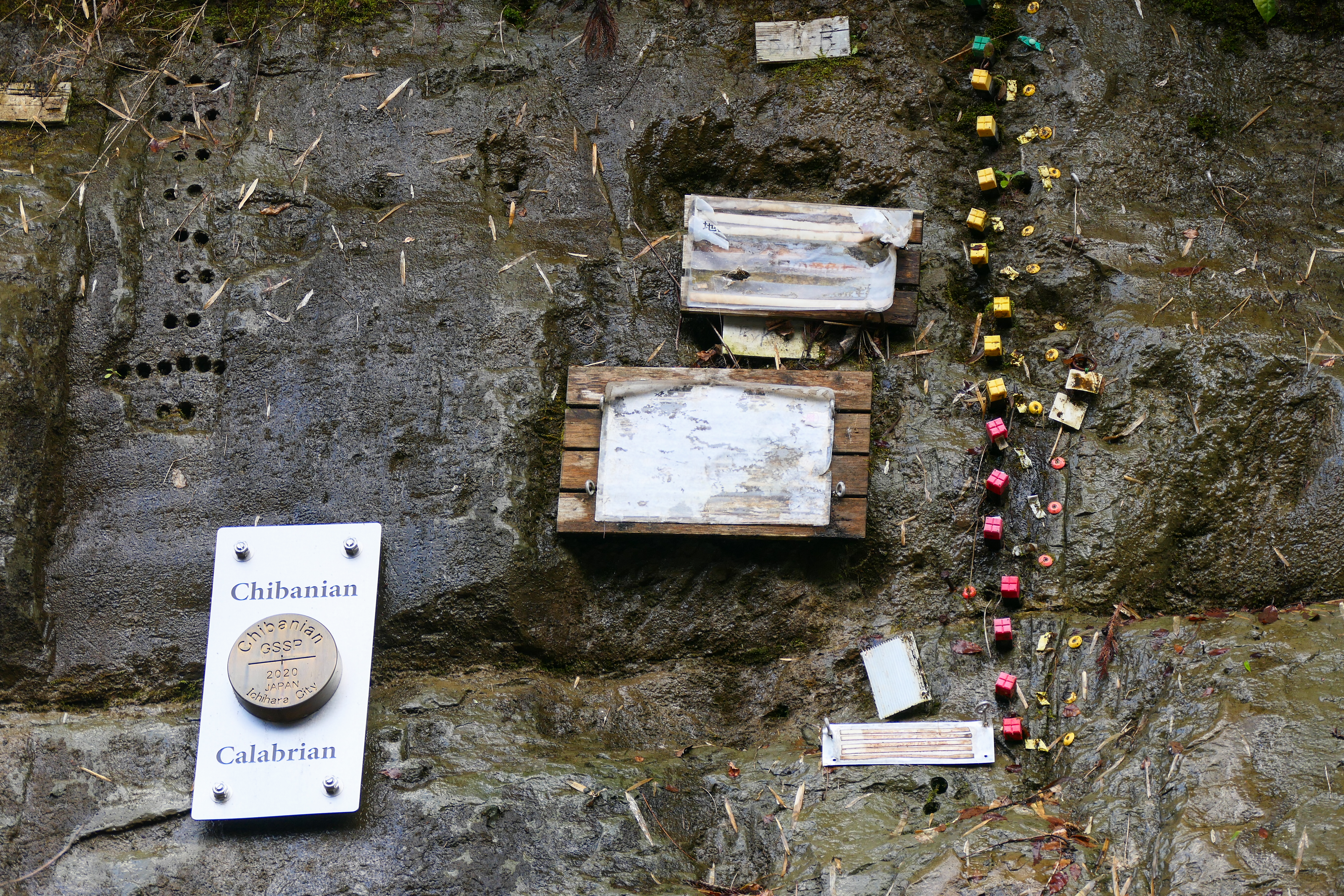
The Brunhes–Matuyama reversal, named after Bernard Brunhes and Motonori Matuyama, was a geologic event, approximately 781,000 years ago, when the Earth's magnetic field last underwent reversal. Estimations vary as to the abruptness of the reversal. A 2004 paper estimated that it took over several thousand years; a 2010 paper estimated that it occurred more quickly, perhaps within a human lifetime; a 2019 paper estimated that the reversal lasted 22,000 years. The apparent duration at any particular location can vary by an order of magnitude, depending on geomagnetic latitude and local effects of non-dipole components of the Earth's field during the transition. The Brunhes–Matuyama reversal is a marker for the Global Boundary Stratotype Section and Point (GSSP) defining the base of the Chibanian Stage and Middle Pleistocene Subseries at the Chiba section, Japan, which was officially ratified in 2020 by the International Union of Geological Sciences. It is useful in dating oce ... [...More Info...] [...Related Items...] OR: [Wikipedia] [Google] [Baidu] |
Bernard Brunhes
Antoine Joseph Bernard Brunhes (3 July 1867 – 10 May 1910) was a French geophysicist known for his pioneering work in paleomagnetism, in particular, his 1906 discovery of geomagnetic reversal. The current period of normal polarity, ''Brunhes Chron'', and the Brunhes–Matuyama reversal are named for him. Brunhes was educated at the École Normale Supérieure in Paris, from which he graduated as an '' agrégé'' qualified in physics. Appointed at Université Lille Nord de France, he taught physics and electrical engineering at École centrale de Lille from 1893 to 1895. In November 1900, he was appointed as head of the Puy-de-Dôme Observatory, built on an extinct volcano in the Auvergne region of France, where he worked until his death in 1910. It was during his time at the observatory that he made the crucial observation that led to his discovery of geomagnetic reversal. In 1905, he found that rocks in an ancient lava flow at Pontfarin in the commune of Cézens (part ... [...More Info...] [...Related Items...] OR: [Wikipedia] [Google] [Baidu] |
Motonori Matuyama
was a Japanese geophysicist who was (in the late 1920s) the first to provide systematic evidence that the Earth's magnetic field had been reversed in the early Pleistocene and to suggest that long periods existed in the past in which the polarity was reversed. He remarked that the Earth's field had later changed to the present polarity. The era of reversed polarity preceding the current ''Brunhes Chron'' of normal polarity is now called the ''Matuyama Reversed Chron''; and the transition between them is called the ''Brunhes–Matuyama'' or ''Matuyama-Brunhes'' reversal. Life Matuyama Motonori was born at Uyeda (now Usa) in Oita prefecture Japan on October 25, 1884, a son of a Zen abbot, Sumie (Sumiye) Tengai. His name was at first registered as Suehara Motonori after his mother’s family name, Suehara Kou, and was later changed to Sumie Motonori when his father became the chief priest at an eminent Zen Buddhist temple in Yamaguchi. In 1910 he was adopted by the Matsuyama (松 ... [...More Info...] [...Related Items...] OR: [Wikipedia] [Google] [Baidu] |
Geology
Geology (). is a branch of natural science concerned with the Earth and other astronomical objects, the rocks of which they are composed, and the processes by which they change over time. Modern geology significantly overlaps all other Earth sciences, including hydrology. It is integrated with Earth system science and planetary science. Geology describes the structure of the Earth on and beneath its surface and the processes that have shaped that structure. Geologists study the mineralogical composition of rocks in order to get insight into their history of formation. Geology determines the relative ages of rocks found at a given location; geochemistry (a branch of geology) determines their absolute ages. By combining various petrological, crystallographic, and paleontological tools, geologists are able to chronicle the geological history of the Earth as a whole. One aspect is to demonstrate the age of the Earth. Geology provides evidence for plate tectonics, the ev ... [...More Info...] [...Related Items...] OR: [Wikipedia] [Google] [Baidu] |
Earth's Magnetic Field
Earth's magnetic field, also known as the geomagnetic field, is the magnetic field that extends from structure of Earth, Earth's interior out into space, where it interacts with the solar wind, a stream of charged particles emanating from the Sun. The magnetic field is generated by electric currents due to the motion of convection currents of a mixture of molten iron and nickel in Earth's outer core: these convection currents are caused by heat escaping from the core, a natural process called a geodynamo. The magnitude of Earth's magnetic field at its surface ranges from . As an approximation, it is represented by a field of a magnetic dipole currently tilted at an angle of about 11° with respect to Earth's rotational axis, as if there were an enormous bar magnet placed at that angle through the center of Earth. The North geomagnetic pole (Ellesmere Island, Nunavut, Canada) actually represents the South pole of Earth's magnetic field, and conversely the South geomagnetic ... [...More Info...] [...Related Items...] OR: [Wikipedia] [Google] [Baidu] |
Geomagnetic Reversal
A geomagnetic reversal is a change in the Earth's Dipole magnet, dipole magnetic field such that the positions of magnetic north and magnetic south are interchanged (not to be confused with North Pole, geographic north and South Pole, geographic south). The Earth's magnetic field has alternated between periods of ''normal'' polarity, in which the predominant direction of the field was the same as the present direction, and ''reverse'' polarity, in which it was the opposite. These periods are called ''polarity chron, chrons''. Reversal occurrences appear to be statistically random. There have been at least 183 reversals over the last 83 million years (thus on average once every ~450,000 years). The latest, the Brunhes–Matuyama reversal, occurred 780,000 years ago with widely varying estimates of how quickly it happened. Some sources estimate the most recent four reversals took on average 7,000 years to occur. Clement (2004) suggests that this duration is dependent on latitude ... [...More Info...] [...Related Items...] OR: [Wikipedia] [Google] [Baidu] |
Global Boundary Stratotype Section And Point
A Global Boundary Stratotype Section and Point (GSSP), sometimes referred to as a golden spike, is an internationally agreed upon reference point on a stratigraphic section which defines the lower boundary of a stage on the geologic time scale. The effort to define GSSPs is conducted by the International Commission on Stratigraphy, a part of the International Union of Geological Sciences. Most, but not all, GSSPs are based on paleontological changes. Hence GSSPs are usually described in terms of transitions between different faunal stages, though far more faunal stages have been described than GSSPs. The GSSP definition effort commenced in 1977. As of 2024, 79 of the 101 stages that need a GSSP have a ratified GSSP. Rules A geologic section has to fulfill a set of criteria to be adapted as a GSSP by the ICS. The following list summarizes the criteria: * A GSSP has to define the lower boundary of a geologic stage. * The lower boundary has to be defined using a primary mar ... [...More Info...] [...Related Items...] OR: [Wikipedia] [Google] [Baidu] |
Chibanian
The Chibanian, more widely known as the Middle Pleistocene (its previous informal name), is an Age (geology), age in the international geologic timescale or a Stage (stratigraphy), stage in chronostratigraphy, being a division of the Pleistocene Epoch within the ongoing Quaternary Period. The Chibanian name was officially ratified in January 2020. It is currently estimated to span the time between 0.7741 annum, Ma (774,100 years ago) and 0.129 Ma (129,000 years ago), also expressed as 774.1–129 ka. It includes the transition in palaeoanthropology from the Lower Paleolithic, Lower to the Middle Paleolithic over 300 ka. The Chibanian is preceded by the Calabrian (stage), Calabrian and succeeded by the Late Pleistocene. The beginning of the Chibanian is the Brunhes–Matuyama reversal, when the Earth's magnetic field last underwent reversal. Its end roughly coincides with the termination of the Penultimate Glacial Period and the onset of the Last Interglacial period (correspondin ... [...More Info...] [...Related Items...] OR: [Wikipedia] [Google] [Baidu] |
International Union Of Geological Sciences
The International Union of Geological Sciences (IUGS) is an international non-governmental organization devoted to global cooperation in the field of geology. As of 2023, it represents more than 1 million geoscientists around the world. About Founded in 1961, the IUGS was established to maintain collaboration between the International Geological Congresses, which have taken place every four years since 1875. It is a Scientific Union member of the International Science Council (ISC), formerly the International Council for Science (ICSU), which it recognizes as the co-ordinating body for the international organization of science. Currently, geologists from 121 countries (and regions) are represented in the IUGS. A broad range of scientific topics is covered by its commission, task groups, joint programmes and affiliated organizations. IUGS promotes and encourages the study of geological problems, especially those of worldwide significance, and supports and facilitates international ... [...More Info...] [...Related Items...] OR: [Wikipedia] [Google] [Baidu] |
Australasian Strewnfield
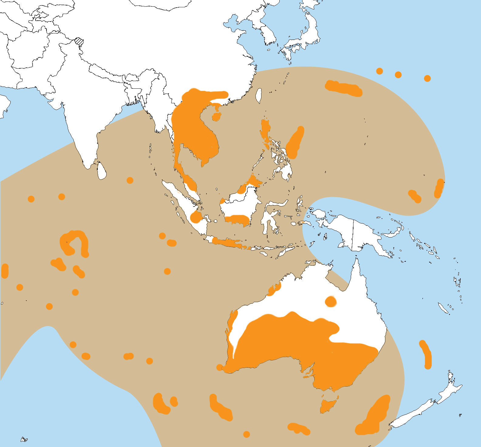
The Australasian strewnfield is the youngest and largest of the tektite strewnfields, with recent estimates suggesting it might cover 10%–30% of the Earth's surface.Glass, B.P. and Wu, J., 1993. ''Coesite and shocked quartz discovered in the, Australasian and North American, microtektite layers.'' ''Geology'', 21(5), pp.435-438.Prasad, M.S., Gupta, S.M. and Kodagali, V.N., 2003. ''Two layers of Australasian impact ejecta in the Indian Ocean?.'' ''Meteoritics & Planetary Science'', 38(9), pp.1373-1381.Prasad, M.S., Mahale, V.P. and Kodagali, V.N., 2007. ''New sites of Australasian microtektites in the central Indian Ocean: Implications for the location and size of source crater.'' ''Journal of Geophysical Research: Planets'', 112, no. E06007, 11 pp. Research indicates that the impact forming the tektites occurred around 788,000 years ago, most likely in Southeast Asia.Jourdan, F., Nomade, S., Wingate, M.T., Eroglu, E. and Deino, A., 2019. ''Ultraprecise age and formation tempera ... [...More Info...] [...Related Items...] OR: [Wikipedia] [Google] [Baidu] |
Lake Bosumtwi
Lake Bosomtwe is the only natural lake in Ghana. It is situated within an ancient impact crater that is about in diameter. It is about south-east of Kumasi, the capital of Ashanti Region, Ashanti, and is a popular recreational area. There are about 30 villages near the Impact crater lake, crater lake of Lake Bosomtwe, with a combined population of about 70,000. The most popular amongst the villages where tourists usually settle is Abono. The Ashanti people, Ashanti consider Bosomtwe a sacred lake. According to traditional belief, the souls of the dead come here to bid farewell to the goddess Asase Ya. Because of this, it is considered permissible to fish in the lake only from wooden Plank (wood), planks. Among the fish species in the lake is the Endemism, endemic cichlid ''Hemichromis frempongi'', and the near-endemic cichlids ''Tilapia busumana'' and ''Tilapia discolor, T. discolor''. Impact crater The Lake Bosomtwe impact crater is in diameter, slightly larger than the pr ... [...More Info...] [...Related Items...] OR: [Wikipedia] [Google] [Baidu] |
Jaramillo Reversal
The Jaramillo reversal was a reversal and excursion of the Earth's magnetic field that occurred approximately one million years ago. In the geological time scale it was a "short-term" positive reversal in the then-dominant Matuyama reversed magnetic chronozone; its beginning is widely dated to 990,000 years before the present ( BP), and its end to 950,000 BP (though an alternative date of 1.07 million years ago to 990,000 is also found in the scientific literature). The causes and mechanisms of short-term reversals and excursions like the Jaramillo, as well as the major field reversals like the Brunhes–Matuyama reversal, are subjects of study and dispute among researchers. One theory associates the Jaramillo with the Bosumtwi impact event, as evidenced by a tektite strewnfield in the Ivory Coast Ivory Coast, also known as Côte d'Ivoire and officially the Republic of Côte d'Ivoire, is a country on the southern coast of West Africa. Its capital city of Yamoussoukro is lo ... [...More Info...] [...Related Items...] OR: [Wikipedia] [Google] [Baidu] |


