|
Bettiah
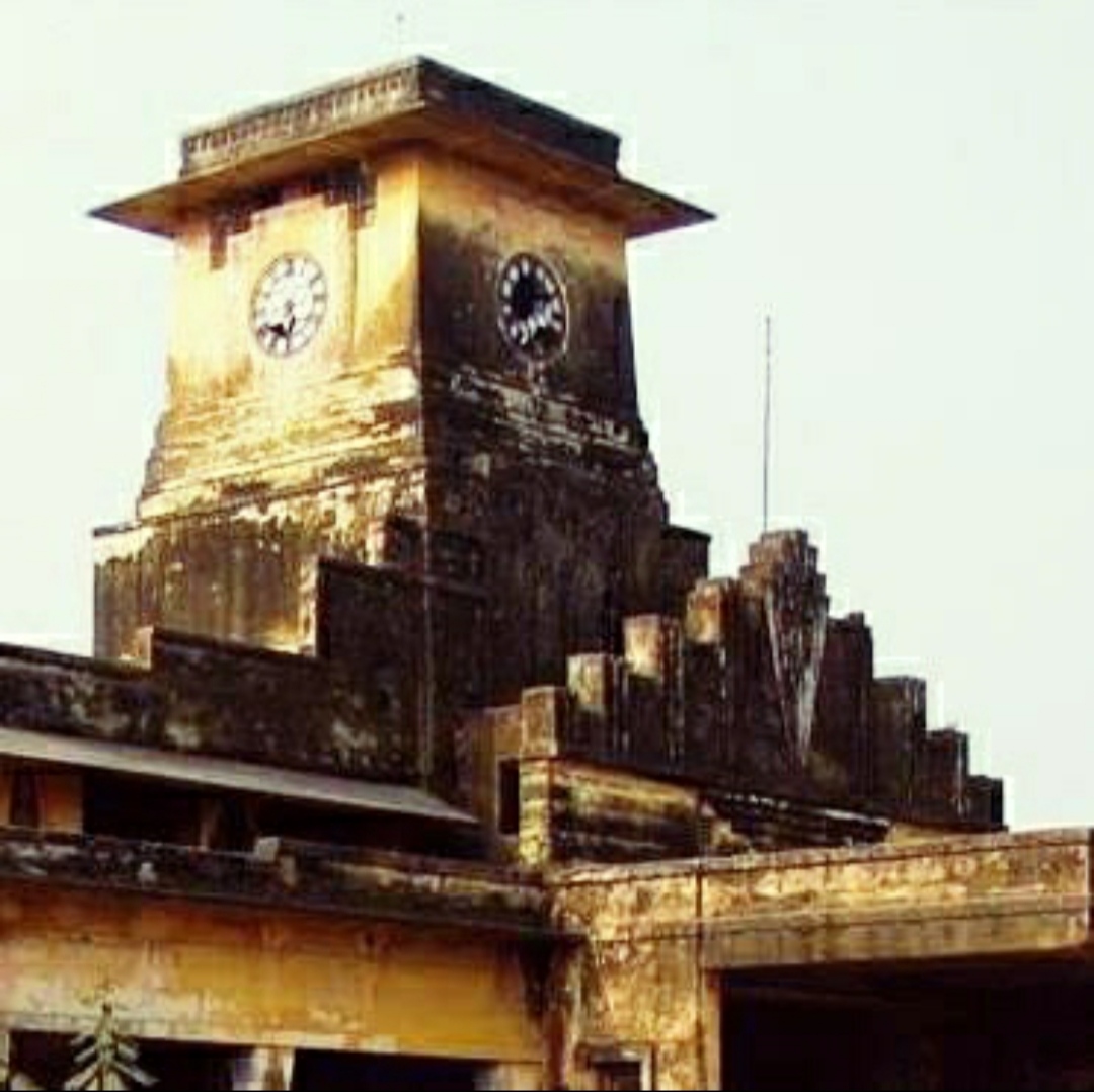
Bettiah is a city and the administrative headquarters of West Champaran district ( Tirhut Division) - ( Tirhut). It is near the Indo-Nepal border, northwest of Patna, in the state of Bihar, India. History In 1244 A.D., Gangeshwar Dev, a Brahmin of the Jaitharia clan, settled at Jaithar in Champaran. One of his descendants, Agar Sen, acquired large territories during the reign of Emperor Jahangir, and was bestowed the title of 'Raja' by Emperor Shah Jahan. In 1659, he was succeeded by his son Raja Gaj Singh, who built the palace of the family at Bettiah. He died in 1694 A.D. The palace stands today and is used as a marketplace. In 1740, a Roman Catholic mission was founded in the city. On 7 December 1745 AD, Father Joseph Mary, Father Cassen, and Nepali Christian Michael arrived in Bettiah from Nepal. The King of Bettiah provided them with a house located in front of the royal court. This three-room house became the center of their activities. One room served as a clini ... [...More Info...] [...Related Items...] OR: [Wikipedia] [Google] [Baidu] |
Giuseppe Maria Bernini
Giuseppe Maria Bernini, also known as Giuseppe Maria da Gargnano ( English: Joseph Mary Bernini, Hindustani: ज्यूसेपे मारिया बेर्निनी (Devanagari), جیوسپی ماریا بیرنینی ( Nastaleeq)), who lived from 1709–1761, was an Italian Capuchin missionary, physician and Orientalist. His efforts led to the establishment of the northern Indian subcontinent's oldest Christian community—the Bettiah Christians. Bernini was the first European to author tracts in Hindustani (Hindi-Urdu), as well as to translate Indian classics from Sanskrit into Italian. Life Bernini was born at Gargnano in Lombardy on 2 September 1709. He met Horatio della Penna of the Tibetan Mission in Rome, and himself travelled to Lhasa. He acquired a knowledge of the languages and dialects of India, being fluent in Hindustani and Sanskrit, as well as in Latin, French, German and Italian. Bernini's skills as a medical doctor were known throughout n ... [...More Info...] [...Related Items...] OR: [Wikipedia] [Google] [Baidu] |
Bettiah (Vidhan Sabha Constituency)
Bettiah Assembly constituency is an assembly constituency in Paschim Champaran district in the Indian state of Bihar. In 2015 Bihar Legislative Assembly election, Bettiah will be one of the 36 seats to have VVPAT enabled electronic voting machines. Overview As per orders of Delimitation of Parliamentary and Assembly constituencies Order, 2008, 8. Bettiah Assembly constituency is composed of the following: Bettiah community development block; and Mohaddipur, Majhaulia, Parsa, Bahuarawa, Gudara, Jaukatia, Bakharia, Rulahi, Rajabhar, Karamawa, Lal Saraiya, Ramnagar Bankat, Amawa Majhar, Majharia Sheikh, Ahawar Kuria, Madhopur, Senuwaria and Bishambharpur gram panchayats of Majhaulia CD Block. Bettiah Assembly constituency is part of 2. Paschim Champaran (Lok Sabha constituency). It was earlier part of Bettiah (Lok Sabha constituency). Members of the Legislative Assembly Election results 2020 2015 2010 References External links * ... [...More Info...] [...Related Items...] OR: [Wikipedia] [Google] [Baidu] |
West Champaran District
West Champaran is an administrative district in the state of Bihar in India, located just west of Birgunj. It is the largest district in Bihar with an area of 5,228 km2(2,019sq mi). It is a part of Tirhut Division. The district headquarters are located in Bettiah. The district is known for its open border with Nepal. One of the major location in West Champaran is Kumar Bagh for SAIL Special Processing Unit and Bhitiharwa where Mahatma Gandhi started Satyagrah Aandolan. The district produces the most sugarcane across the state of Bihar in 2022. History Mahatma Gandhi started the Champaran Satyagraha movement from here in 1917 along with nationalists Rajendra Prasad, Anugrah Narayan Sinha and Brajkishore Prasad. Geography The district occupies an area of , comparatively equivalent to Canada's Amund Ringnes Island. Flora and fauna In 1989 West Champaran district became home to Valmiki National Park, which has an area of . It is also home to two wildlife sanctuaries ... [...More Info...] [...Related Items...] OR: [Wikipedia] [Google] [Baidu] |
Paschim Champaran (Lok Sabha Constituency)
Paschim Champaran Lok Sabha constituency is one of the 40 Lok Sabha (parliamentary) constituencies in Bihar state in eastern India. This constituency came into existence in 2008, following delimitation of the parliamentary constituencies based on the recommendations of the Delimitation Commission of India constituted in 2002. Assembly segments Presently, this constituency comprises six Vidhan Sabha segments, which are: Members of Parliament Election results General election 2024 2019 2014 2009 See also * Bettiah (Lok Sabha constituency) * East Champaran district * West Champaran district * List of constituencies of the Lok Sabha * Bettiah Raj References External linksPaschim Champaran lok sabha constituency election 2019 result details {{DEFAULTSORT:Paschim Champaran (Lok Sabha Constituency) Lok Sabha constituencies in Bihar Politics of West Champaran district Politics of East Champaran district ... [...More Info...] [...Related Items...] OR: [Wikipedia] [Google] [Baidu] |
Bihar
Bihar ( ) is a states and union territories of India, state in Eastern India. It is the list of states and union territories of India by population, second largest state by population, the List of states and union territories of India by area, 12th largest by area, and the List of Indian states and union territories by GDP, 14th largest by GDP in 2024. Bihar borders Uttar Pradesh to its west, Nepal to the north, the northern part of West Bengal to the east, and Jharkhand to the south. Bihar is split by the river Ganges, which flows from west to east. On 15 November 2000, a large chunk of southern Bihar was ceded to form the new state of Jharkhand. Around 11.27% of Bihar's population live in urban areas as per a 2020 report. Additionally, almost 58% of Bihari people, Biharis are below the age of 25, giving Bihar the highest proportion of young people of any Indian state. The official language is Hindi, which shares official status alongside that of Urdu. The main native languag ... [...More Info...] [...Related Items...] OR: [Wikipedia] [Google] [Baidu] |
List Of Districts Of India
A district (''Zila (country subdivision), zila''), also known as revenue district, is an Administrative divisions of India, administrative division of an States and union territories of India, Indian state or territory. In some cases, districts are further subdivided into Revenue division, sub-divisions, and in others directly into tehsil, ''tehsils'' or ''talukas''. , there are a total of 780 districts in India. This count includes Mahe and Yanam which are Census districts and not Administrative districts and also includes the temporary Maha Kumbh Mela district but excludes Itanagar Capital Complex which has a Deputy Commissioner but is not an official district. District Administration ;The District officials include: *District Judge (India), District & Sessions Judge (Principal & additional), an officer belonging to the Judiciary of India, Indian Judicial Service (state), responsible for justice and passing orders of imprisonment, including the Capital punishment, death pena ... [...More Info...] [...Related Items...] OR: [Wikipedia] [Google] [Baidu] |
Patna
Patna (; , ISO 15919, ISO: ''Paṭanā''), historically known as Pataliputra, Pāṭaliputra, is the List of state and union territory capitals in India, capital and largest city of the state of Bihar in India. According to the United Nations, as of 2018, Patna had a population of 2.35 million, making it the List of cities in India by population, 19th largest city in India. Covering and over 2.5 million people, its urban agglomeration is the List of million-plus urban agglomerations in India, 18th largest in India. Patna also serves as the seat of Patna High Court. The Buddhist, Hindu and Jain pilgrimage centres of Vaishali district, Vaishali, Rajgir, Nalanda, Bodh Gaya and Pawapuri are nearby and Patna City is a sacred city for Sikhs as the tenth 10th Sikh Guru, Sikh Guru, Guru Gobind Singh was born here. The modern city of Patna is mainly on the southern bank of the river Ganges. The city also straddles the rivers Son River, Son, Gandak and Punpun River, Punpun. The city ... [...More Info...] [...Related Items...] OR: [Wikipedia] [Google] [Baidu] |
Tirhut
Mithila (), also known as Tirhut, Tirabhukti and Mithilanchal, is a geographical and cultural region of the Indian subcontinent bounded by the Mahananda River in the east, the Ganges in the south, the Gandaki River in the west and by the foothills of the Himalayas in the north. It comprises certain parts of Bihar and Jharkhand states of India and adjoining districts of the Koshi Province, Bagmati Pradesh and Madhesh Province of Nepal. The native language in Mithila is Maithili, and its speakers are referred to as Maithils. Mithila is commonly used to refer to the Videha Kingdom, as well as to the modern-day territories that fall within the ancient boundaries of Videha. Until the 20th century, Mithila was still ruled in part by the Raj Darbhanga. History In Jainism Mithilā is one of the most significant pilgrimage sites in Jainism. Apart from its association with ''Mahavira'', the 24th Tirthankara, it is also known for its association with '' Mallinatha'', the 19th Ti ... [...More Info...] [...Related Items...] OR: [Wikipedia] [Google] [Baidu] |
India–Nepal Border
The India–Nepal border is an Open border, open international boundary running between the republics of India and Nepal. The long border includes the Himalayas, Himalayan territories as well as Indo-Gangetic Plain of the subcontinent. The current Boundary delimitation, border was delimited after the Treaty of Sugauli, Sugauli treaty of 1816 between Nepal and the British Raj. Following Indian independence movement, Indian independence, the prevailing border was recognised as the international border between the Kingdom of Nepal and the Dominion of India. Description The border starts in the west at the western tripoint with China near the Limpuyadhura. It then proceeds to the south-west through the Himalayas, the Sivalik Hills and then the Gangetic plain, initially overland and then utilising the Mahakali River. Just east of Majhola it turns to the south-east and proceeds in that direction overland, occasionally utilising various rivers and hill crests. North-west of Islampur, Ut ... [...More Info...] [...Related Items...] OR: [Wikipedia] [Google] [Baidu] |
Brahmin
Brahmin (; ) is a ''Varna (Hinduism), varna'' (theoretical social classes) within Hindu society. The other three varnas are the ''Kshatriya'' (rulers and warriors), ''Vaishya'' (traders, merchants, and farmers), and ''Shudra'' (labourers). The traditional occupation of Brahmins is that of priesthood (purohit, pandit, or pujari) at Hindu temples or at socio-religious ceremonies, and the performing of rite of passage rituals, such as solemnising a wedding with hymns and prayers.James Lochtefeld (2002), Brahmin, The Illustrated Encyclopedia of Hinduism, Vol. 1: A–M, Rosen Publishing, , page 125 Traditionally, Brahmins are accorded the supreme ritual status of the four social classes, and they also served as spiritual teachers (guru or acharya). In practice, Indian texts suggest that some Brahmins historically also became agriculturalists, warriors, traders, and had also held other occupations in the Indian subcontinent.GS Ghurye (1969), Caste and Race in India, Popular Prakasha ... [...More Info...] [...Related Items...] OR: [Wikipedia] [Google] [Baidu] |
India
India, officially the Republic of India, is a country in South Asia. It is the List of countries and dependencies by area, seventh-largest country by area; the List of countries by population (United Nations), most populous country since 2023; and, since its independence in 1947, the world's most populous democracy. Bounded by the Indian Ocean on the south, the Arabian Sea on the southwest, and the Bay of Bengal on the southeast, it shares land borders with Pakistan to the west; China, Nepal, and Bhutan to the north; and Bangladesh and Myanmar to the east. In the Indian Ocean, India is near Sri Lanka and the Maldives; its Andaman and Nicobar Islands share a maritime border with Thailand, Myanmar, and Indonesia. Modern humans arrived on the Indian subcontinent from Africa no later than 55,000 years ago., "Y-Chromosome and Mt-DNA data support the colonization of South Asia by modern humans originating in Africa. ... Coalescence dates for most non-European populations averag ... [...More Info...] [...Related Items...] OR: [Wikipedia] [Google] [Baidu] |


