|
Betpak-Dala
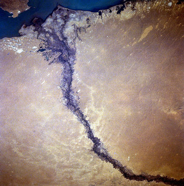
Betpak-Dala or Betpaqdala (, ''Betpaqdala''; from Turkic ''batpak'', “swampy,” or Persian ''bedbaht'', “unlucky” and Turkic ''dala'', “plain”; Russian: Бетпак-Дала or Сeверная Голодная степь, lit. ''Hungry Steppe'') is a desert zone in the Ulytau, Karaganda, Turkestan, and Zhambyl regions, Kazakhstan. - Great Russian Encyclopedia in 35 volumes / ch. ed. Yu. S. Osipov History In Autumn 2014, English explorer Jamie Bunchuk completed an expedition to cross the Betpak-Dala to its fullest longitudinal extent, from Lake B ...[...More Info...] [...Related Items...] OR: [Wikipedia] [Google] [Baidu] |
Betpak-Dala Desert
Betpak-Dala or Betpaqdala (, ''Betpaqdala''; from Turkic ''batpak'', “swampy,” or Persian ''bedbaht'', “unlucky” and Turkic ''dala'', “plain”; Russian language, Russian: Бетпак-Дала or Сeверная Голодная степь, lit. ''Hungry Steppe'') is a desert zone in the Ulytau Region, Ulytau, Karaganda Region, Karaganda, Turkistan Region, Turkestan, and Zhambyl Region, Zhambyl regions, Kazakhstan. - Great Russian Encyclopedia in 35 volumes / ch. ed. Yu. S. Osipov History In Autumn 2014, English explorer Jamie Bunchuk completed an expedition to cross the Betpak-Dala to its fullest longitudinal extent, from Lake Balkash in the east to the Sarysu River in the west. He also ran 190 miles, nearly eight marathons, back-to-back, over the course of eight days within the region. An ...[...More Info...] [...Related Items...] OR: [Wikipedia] [Google] [Baidu] |
Saiga Antelope
The saiga antelope (, ''Saiga tatarica''), or saiga, is a species of antelope which during antiquity inhabited a vast area of the Eurasian steppe, spanning the foothills of the Carpathian Mountains in the northwest and Caucasus in the southwest into Mongolia in the northeast and Dzungaria in the southeast. During the Pleistocene, it ranged across the mammoth steppe from the British Isles to Beringia. Today, the dominant subspecies (''S. t. tatarica'') only occurs in Kalmykia and Astrakhan Oblast of Russia and in the Ural, Ustyurt and Betpak-Dala regions of Kazakhstan. A portion of the Ustyurt population migrates south to Uzbekistan and occasionally to Turkmenistan in winter. It is regionally extinct in Romania, Ukraine, Moldova, China and southwestern Mongolia. The Mongolian subspecies (''S. t. mongolica'') occurs only in western Mongolia. Taxonomy and phylogeny The scientific name ''Capra tatarica'' was coined by Carl Linnaeus in 1766 in the 12th edition of ''Systema Natu ... [...More Info...] [...Related Items...] OR: [Wikipedia] [Google] [Baidu] |
Buralkynyn Tuzy
Buralkynyn Tuzy (; ) is a salt lake in Sarysu District, Zhambyl Region, Kazakhstan. Zhailaukol village is located to the south of the southern shore. Geography Buralkynyn Tuzy is a sor-type of lake in the Chu basin. It is located to the west of high Mount Andagul in an arid zone at the southern edge of the Betpak-Dala, north of the lower Chu valley. The Chu river flows westwards to the south of the lake. The western part of the lake basin is flat and the eastern is steep.Google Earth The lake fills during the spring thaw and usually dries up completely in the summer. If it has water at the end of the fall, it does not freeze in the winter owing to its high salinity.''Kazakhstan National encyclopedia'' / Chief editor A. Nysanbayev - Almaty, 1998. ISBN 5-89800-123-9 See also * Kazakh semi-desert *List of lakes of Kazakhstan Excluding the northernmost districts, Kazakhstan consists of endorheic basins, where rivers flow into one of the numerous lakes. The most important ... [...More Info...] [...Related Items...] OR: [Wikipedia] [Google] [Baidu] |
Arys (lake)
Arys (; ), is a salt lake in Syrdariya District, Kyzylorda Region, Kazakhstan. The waters of the lake are mineral-rich, averaging and containing, besides sodium chloride, iodine, fluorine, bromine, boron, zinc, manganese and iron. Geography The lake lies in the western part of the Betpak-Dala semi-desert region, about to the NNE of Kyzylorda town. In the same manner as most lakes in the region, Arys is an endorheic lake which is fed by underground sources located near the shores or along the lake bottom.Арыс '''' in 30 vols. — Ch. ed. |
Karakoin
Karakoin (; ) is a salt lake in Ulytau District, Ulytau Region, Kazakhstan. It is the largest lake in the district. The area around Karakoin is sparsely inhabited. The lake basin is a seasonal grazing ground for local cattle. Geography Karakoin is an endorheic lake in the Sarysu basin. It is located in an arid zone at the northern edge of the Betpak-Dala. The western lakeshore is nearly straight and rises abruptly from the lake surface, while the eastern is low, marshy and deeply indented. There are some small islands close to the eastern lakeshore.Google Earth The lake fills during the spring thaw, with intermittent rivers Katagansay and Taldyespe flowing into it and bringing the lake to reach a surface of to in years of abundant snowfall. Usually it almost dries completely in the summer. The bottom of the lake is flat and muddy. The mud is reputed to have medicinal properties. [...More Info...] [...Related Items...] OR: [Wikipedia] [Google] [Baidu] |
Sor (geomorphology)
A sor (; ) is a closed drainless depression characteristic of the Central Asian deserts, found especially in Kazakhstan. The sor area is seasonally flooded, forming a lake, which becomes an inland salt marsh and then a Salt pan (geology), salt flat as it dries.''Kazakh traditional system of ethnographic categories, concepts and names;'' in Kazakh National Encyclopedia. Volume 5. Page 226. "Asia Channel" publishing house. Almaty, 2014 The term forms part of some toponyms of Kazakhstan, such as Altybaysor, Aralsor, Atansor, Azhibeksor, Bauzhansor, Karasor, Koksengirsor, Mangisor, Maysor, Meshkeysor, Shandaksor, Sholaksor, Shureksor, Sorasha, Sorkol (Chu basin), Sorkol, Sormoildy, Tuzdysor, Zhaltyrsor, Zhyngyldysor and Sor Tuzbair. Description A sor forms in the flatland of arid areas or deserts. Heavy seasonal rains taking place usually in the spring bring the water to accumulate at the bottom of the depression. The intermittent lake is characterized by a clear-cut coastline. As th ... [...More Info...] [...Related Items...] OR: [Wikipedia] [Google] [Baidu] |
Zheltau (Jambyl Region)
Zheltau () is an elongated upland located in Jambyl Region, Kazakhstan. Mirny, a mining town in the Moiynkum District, lies at the southeastern end of the Zheltau. The area is a seasonal grazing ground for local cattle. Geography Zheltau is located at the western limit of the Balkhash-Alakol Basin, roughly to the west of the southwestern shore of Lake Balkhash. It extends from northwest to southeast for about . The Betpak-Dala desert lies to the west. The Zheltau stretches northwestwards from the northern end of the Chu-Ili Range, with the Maizharylgan running parallel to its southern stretch. high Mount Zhambyl rises to the southwest of the southern section of the Zheltau.Google Earth The Zheltau upland forms an almost continuous elevated terrain of moderate height. Located near the northern end, high Mount Suykadyr is the highest point. Flora The vast hilly area is covered with resilient grasses such as ''Festuca'', ''Aristida'', ''Calamagrostis'', '' Artemisia'', ' ... [...More Info...] [...Related Items...] OR: [Wikipedia] [Google] [Baidu] |
Ashchykol Depression
The Ashchykol Depression (), is a depression in the Turkistan and Kyzylorda regions, Kazakhstan.Google Earth The village of Taykonyr, Suzak District, Turkistan Region is located in the depression. The Ashchykol zone includes a Important Bird Area. Geography The Ashchykol Depression lies between the lowest reaches of the Sarysu in the west and the mouth of the Chu river in the east. It extends roughly from east to west for a length of roughly to the southwest of the Betpak-Dala desert, west of the Moiynkum Desert and north of the northwestern end of the Karatau Range. It is a largely flat endorheic basin filled with mixed sand and clay deposits, as well as sandy alluvial sediments. There are numerous intermittent salt lakes and sors. The main lakes are Akzhaikyn and Ashchykol. In wet years the Chu river may reach lake Akzhaikyn at the eastern end and the Boktykaryn the Ashchykol lake. At the western end the Sarysu river usually ends in the Telikol lake. The latter is lo ... [...More Info...] [...Related Items...] OR: [Wikipedia] [Google] [Baidu] |
Jamie Bunchuk
James Benjamin Maddison (born 9 July 1988), formerly known as Jamie Bunchuk, is an English explorer, equestrian Long Rider (assoc.) and an editor of '' Sidetracked'' magazine. He is best known for his exploration of the Central Asia region. Maddison's first expedition was to the Djangart Valley of the Tian Shan mountains in eastern Kyrgyzstan. Since then, he has mounted numerous expeditions including: spending one month living and working with Kirghiz hunters in southeast Tajikistan, small archaeological discoveries from the X-XI C. Sak city of Bazar Dara, a 100 mile, multi-day, camel supported run across the Red Sands Desert in Uzbekistan, chronicling the lives of Kazakh eagle hunters in western Mongolia and winter packrafting down the Khovd River, Mongolia (temperatures down to -20 °C) in retrofitted and homemade packrafts. In 2013, Maddison – alongside friend and colleague Matthew Traver – completed a 750 mile, 63-day-long, horse ride from Ust-Kamenogorsk to Almaty, ... [...More Info...] [...Related Items...] OR: [Wikipedia] [Google] [Baidu] |
Lake Balkash
Lake Balkhash, also spelt Lake Balqash (, , ), is a lake in southeastern Kazakhstan, one of the largest lakes in Asia and the 15th largest in the world. It is located in the eastern part of Central Asia and sits in the Balkhash-Alakol Basin, an endorheic (closed) basin. The basin drains seven rivers, the primary of which is the Ili, bringing most of the riparian inflow; others, such as the Karatal, bring surface and subsurface flow. The Ili is fed by precipitation, largely vernal snowmelt, from the mountains of China's Xinjiang region. The lake currently covers about . However, like the Aral Sea, it is shrinking due to diversion and extraction of water from its feeders. The lake has a narrow, quite central, strait. The lake's western part is fresh water and its eastern half is saline. The eastern part is on average 1.7 times deeper than the west. The largest shore city is named Balkhash and has about 66,000 inhabitants. Main local economic activities include mining, ore p ... [...More Info...] [...Related Items...] OR: [Wikipedia] [Google] [Baidu] |
Paleogene
The Paleogene Period ( ; also spelled Palaeogene or Palæogene) is a geologic period and system that spans 43 million years from the end of the Cretaceous Period Ma (million years ago) to the beginning of the Neogene Period Ma. It is the first period of the Cenozoic Era, the tenth period of the Phanerozoic and is divided into the Paleocene, Eocene, and Oligocene epochs. The earlier term Tertiary Period was used to define the time now covered by the Paleogene Period and subsequent Neogene Period; despite no longer being recognized as a formal stratigraphic term, "Tertiary" still sometimes remains in informal use. Paleogene is often abbreviated "Pg", although the United States Geological Survey uses the abbreviation "" for the Paleogene on the Survey's geologic maps. Much of the world's modern vertebrate diversity originated in a rapid surge of diversification in the early Paleogene, as survivors of the Cretaceous–Paleogene extinction event took advantage of empty ecolo ... [...More Info...] [...Related Items...] OR: [Wikipedia] [Google] [Baidu] |
Anabasis Salsa
Anabasis (from Greek ''ana'' = "upward", ''bainein'' = "to step or march") is an expedition from a coastline into the interior of a country. Anabase and Anabasis may also refer to: History * ''Anabasis Alexandri'' (''Anabasis of Alexander''), a history of the campaigns of Alexander the Great by Greek historian Arrian * Anabasis (Xenophon), ''Anabasis'' (Xenophon), a history of the expedition of Cyrus the Younger by Greek writer Xenophon * Siberian Anabasis, a literary name for Czechoslovak Legions#Transit through Siberia, the Czechoslovak Legions' transit through Siberia during the Russian Civil War, in reference to the epic of Xenophon Poetry and fiction * "", a 1924 poem by Saint-John Perse * "Anabasis", a 1930 translation of Saint-John Perse's poem by T. S. Eliot * "Anabasis", poem by Paul Celan, published 1963 in ''Die Niemandsrose'' * ''Anabasis'', a 1994 novel by Ellen Gilchrist * ''Anabasis'', a novel of Hellenistic Afghanistan and India by Geoffrey Storey Music * ''Anab ... [...More Info...] [...Related Items...] OR: [Wikipedia] [Google] [Baidu] |


