|
Bagram
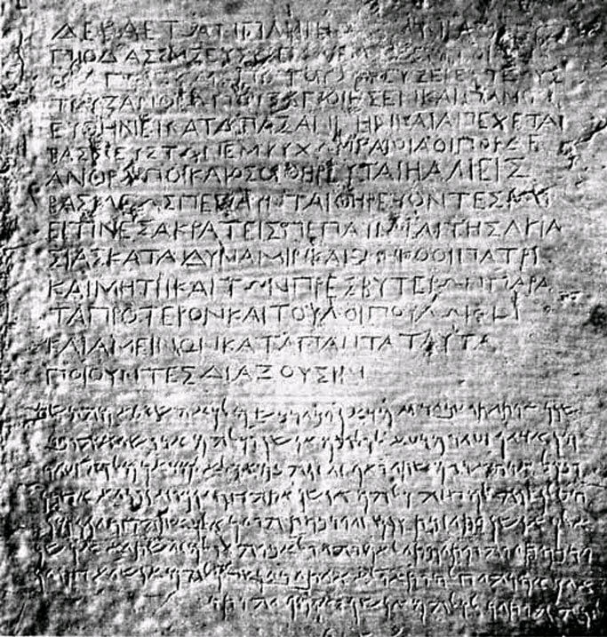
Bagram (; Pashto/) is a town and seat in Bagram District in Parwan Province of Afghanistan, about 60 kilometers north of the capital Kabul. It is the site of an ancient city located at the junction of the Ghorband and Panjshir Valley, near today's city of Charikar, Afghanistan. The location of this historical town made it a key passage from Ancient India along the Silk Road, leading westwards through the mountains towards Bamiyan, and north over the Kushan Pass to the Baghlan Valley and past the Kushan archeological site at Surkh Kotal, to the commercial centre of Balkh and the rest of northern Afghanistan. Bagram was the capital of the Kushan Empire in the first century CE. History Ancient history The ancient city of Kapisi is identified with present-day Bagram. The figures of ancient Buddhist and Hindu sculptures show that the city was initially ruled by Indic people who have either migrated or intermingled with the Iranian populations who moved into the region ... [...More Info...] [...Related Items...] OR: [Wikipedia] [Google] [Baidu] |
Bagram Airfield
Bagram Airfield-BAF, also known as Bagram Air Base , is located southeast of Charikar in the Parwan Province of Afghanistan. It is under the Ministry of Defense (Afghanistan), Afghan Ministry of Defense. Sitting on the site of the ancient town of Bagram at an elevation of above sea level, the air base has two concrete runways. The main one measures , capable of handling large military aircraft, including the Lockheed Martin C-5 Galaxy. The second runway measures . The air base also has at least three large hangars, a control tower, numerous support buildings, and various housing areas. There are also more than of ramp space and five aircraft dispersal areas, with over 110 Revetment (aircraft), revetments. Bagram Air Base was formerly the largest List of American military installations, U.S. military base in Afghanistan, staffed by the 455th Air Expeditionary Wing of the United States Air Force, U.S. Air Force, along with rotating units of the U.S. and coalition forces. It was ... [...More Info...] [...Related Items...] OR: [Wikipedia] [Google] [Baidu] |
Parwan Province
Parwan also spelled Parvan () is one of the 34 provinces of Afghanistan. It is the largest province of the Greater Parwan region and has a population of about 751,000. The province is multi-ethnic and mostly rural society. The province is divided into ten Districts of Afghanistan, districts. The town of Charikar, Imam Abu Hanifa serves as the provincial capital. The province is located north of Kabul Province and south of Baghlan Province, west of Panjshir Province and Kapisa Province, and east of Maidan Wardak Province and Bamyan Province. The province's famous tourism attraction is the Golghondi Hill, also known as “the flower hill,” located in Imam Azam about an hour away from the capital city of Kabul. After Panjshir this province has been considered as one of the main raising points of Afghanistan War against Soviets. The name Parwan is also attributed to a town, the exact location of which is now unknown, that supposedly existed during prehistory, in the nearby Hindu K ... [...More Info...] [...Related Items...] OR: [Wikipedia] [Google] [Baidu] |
Districts Of Afghanistan
The districts of Afghanistan, known as ''wuleswali'' (, ''wuləswāləi''; , ''wuləswālī''; ''ulasvolik''), are secondary-level administrative units, one level below Provinces of Afghanistan, provinces. The Afghan government issued its first district map in 1973. It recognized 325 districts, counting ''wuleswalis'' (districts), ''alaqadaries'' (sub-districts), and ''markaz-e-wulaiyat'' (provincial center districts). In the ensuing years, additional districts have been added through splits, and some eliminated through merges. In June 2005, the Afghan government issued a map of 398 districts. It was widely adopted by many information management systems, though usually with the addition of ''Sharak-e-Hayratan'' for 399 districts in total. It remains the ''de facto'' standard as of late 2018, despite a string of government announcements of the creation of new districts. The latest announced set includes 421 districts. The country's Central Statistics Office (CSO) and the Indepe ... [...More Info...] [...Related Items...] OR: [Wikipedia] [Google] [Baidu] |
Bagram District
Bagram () is a district of Parwan province, Afghanistan. Its seat lies at Bagram, which lies about 60 kilometers north of the capital of Kabul. It borders Kabul District to the south, Shinwari District to the east, and Chaharikar District to the north. History Historically this district was known for its rhinoceros hunting. Haji Abdul Qader also commanded some 200 Mujahideen in Bagram District during the war against the Soviet Union, with a permanent base located at Deh Babi near Abdullah-e Burj. See also * Districts of Afghanistan The districts of Afghanistan, known as ''wuleswali'' (, ''wuləswāləi''; , ''wuləswālī''; ''ulasvolik''), are secondary-level administrative units, one level below Provinces of Afghanistan, provinces. The Afghan government issued its fir ... References Districts of Parwan Province {{Parwan-geo-stub ... [...More Info...] [...Related Items...] OR: [Wikipedia] [Google] [Baidu] |
Kabul
Kabul is the capital and largest city of Afghanistan. Located in the eastern half of the country, it is also a municipality, forming part of the Kabul Province. The city is divided for administration into #Districts, 22 municipal districts. A 2025 estimate puts the city's population at 7.175 million. In contemporary times, Kabul has served as Afghanistan's political, cultural and economical center. Rapid urbanisation has made it the country's primate city and one of the largest cities in the world. The modern-day city of Kabul is located high in a narrow valley in the Hindu Kush mountain range, and is bounded by the Kabul River. At an elevation of , it is one of the List of capital cities by elevation, highest capital cities in the world. The center of the city contains its old neighborhoods, including the areas of Khashti Bridge, Khabgah, Kahforoshi, Saraji, Chandavel, Shorbazar, Deh-Afghanan and Ghaderdiwane. Kabul is said to be over 3,500 years old, and was mentioned at the ... [...More Info...] [...Related Items...] OR: [Wikipedia] [Google] [Baidu] |
Kapisi
The Kingdom of Kapisa, appearing in contemporary Chinese sources as () and (), was a state located in what is now Afghanistan during the late 1st millennium. Its capital was the city of Kapisa. The kingdom stretched from the Hindu Kush in the north to Bamiyan and Kandahar in the south and west, out as far as the modern Jalalabad District in the east. The name Kapisa appears to be a Sanskritized form of an older name for the area, from prehistory. Following its conquest in 329 BC by Alexander the Great, Bagram and the surrounding area were known in the Hellenic world as Alexandria on the Caucasus in reference to the Hindu Kush as the "Indic Caucasus", although the older name appears to have survived. In the early 7th century, the Chinese Buddhist monk Xuanzang made a pilgrimage to Kapisa, and described there the cultivation of rice and wheat, and a king of the Suli tribe. In his chronicle, he relates that in Kapisa were over 6,000 monks of the Mahayana school of Buddhism. ... [...More Info...] [...Related Items...] OR: [Wikipedia] [Google] [Baidu] |
Kushan Empire
The Kushan Empire (– CE) was a Syncretism, syncretic empire formed by the Yuezhi in the Bactrian territories in the early 1st century. It spread to encompass much of what is now Afghanistan, Eastern Iran, India, Pakistan, Tajikistan and Uzbekistan. Kushan territory in India went at least as far as Saketa and Sarnath, now near Varanasi district, Varanasi in Uttar Pradesh, where inscriptions have been found dating to the era of the Kushan emperor Kanishka the Great. The Kushans were most probably one of five branches of the Yuezhi confederation, an Proto-Indo-Europeans, Indo-European nomadic people of possible Tocharians, Tocharian origin, who migrated from northwestern China (Xinjiang and Gansu) and settled in ancient Bactria. The founder of the dynasty, Kujula Kadphises, followed Iranian and Greek cultural ideas and iconography after the Greco-Bactrian tradition and was a follower of the Shaivism, Shaivite sect of Hinduism. Two later Kushan kings, Vima Kadphises and Vasudeva ... [...More Info...] [...Related Items...] OR: [Wikipedia] [Google] [Baidu] |
Afghanistan
Afghanistan, officially the Islamic Emirate of Afghanistan, is a landlocked country located at the crossroads of Central Asia and South Asia. It is bordered by Pakistan to the Durand Line, east and south, Iran to the Afghanistan–Iran border, west, Turkmenistan to the Afghanistan–Turkmenistan border, northwest, Uzbekistan to the Afghanistan–Uzbekistan border, north, Tajikistan to the Afghanistan–Tajikistan border, northeast, and China to the Afghanistan–China border, northeast and east. Occupying of land, the country is predominantly mountainous with plains Afghan Turkestan, in the north and Sistan Basin, the southwest, which are separated by the Hindu Kush mountain range. Kabul is the country's capital and largest city. Demographics of Afghanistan, Afghanistan's population is estimated to be between 36 and 50 million. Ancient history of Afghanistan, Human habitation in Afghanistan dates to the Middle Paleolithic era. Popularly referred to as the graveyard of empire ... [...More Info...] [...Related Items...] OR: [Wikipedia] [Google] [Baidu] |
Silk Routes
The Silk Road was a network of Asian trade routes active from the second century BCE until the mid-15th century. Spanning over , it played a central role in facilitating economic, cultural, political, and religious interactions between the Eastern and Western worlds. The name "Silk Road" was coined in the late 19th century, but some 20th- and 21st-century historians instead prefer the term Silk Routes, on the grounds that it more accurately describes the intricate web of land and sea routes connecting Central, East, South, Southeast, and West Asia as well as East Africa and Southern Europe. The Silk Road derives its name from the highly lucrative trade of silk textiles that were primarily produced in China. The network began with the expansion of the Han dynasty (202 BCE220 CE) into Central Asia around 114 BCE, through the missions and explorations of the Chinese imperial envoy Zhang Qian, which brought the region under unified control. The Chinese took g ... [...More Info...] [...Related Items...] OR: [Wikipedia] [Google] [Baidu] |
Mauryan Dynasty
The Maurya Empire was a geographically extensive Iron Age historical power in South Asia with its power base in Magadha. Founded by Chandragupta Maurya around c. 320 BCE, it existed in loose-knit fashion until 185 BCE. The primary sources for the written records of the Mauryan times are partial records of the lost history of Megasthenes in Roman texts of several centuries later; the Edicts of Ashoka, which were first read in the modern era by James Prinsep after he had deciphered the Brahmi and Kharoshthi scripts in 1838; and the ''Arthashastra'', a work first discovered in the early 20th century,: "... another source that enjoyed high standing as a description of the early Mauryan state was the Arthashastra, a treatise on power discovered in the early twentieth century." and previously attributed to Chanakya, but now thought to be composed by multiple authors in the first centuries of the common era. Archaeologically, the period of Mauryan rule in South Asia falls in ... [...More Info...] [...Related Items...] OR: [Wikipedia] [Google] [Baidu] |
Bactria
Bactria (; Bactrian language, Bactrian: , ), or Bactriana, was an ancient Iranian peoples, Iranian civilization in Central Asia based in the area south of the Oxus River (modern Amu Darya) and north of the mountains of the Hindu Kush, an area within the north of modern Afghanistan, Tajikistan and Uzbekistan. Bactria was strategically located south of Sogdia and the western part of the Pamir Mountains. The extensive mountain ranges acted as protective "walls" on three sides, with the Pamir on the north and the Hindu Kush on south forming a junction with the Karakoram, Karakoram range towards the east. Called "beautiful Bactria, crowned with flags" by the Avesta, the region is considered, in the Zoroastrianism, Zoroastrian faith, to be one of the "Avestan geography, sixteen perfect Iranian lands" that the supreme deity, Ahura Mazda, had created. It was once a small and independent kingdom struggling to exist against nomadic Turya (Avesta), Turanians. One of the early centres of ... [...More Info...] [...Related Items...] OR: [Wikipedia] [Google] [Baidu] |


