|
A4085 Road
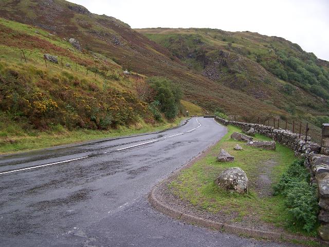
The A4085 is a 20-mile road between Caernarfon and Penrhyndeudraeth in North Wales that runs through the scenic Aberglaslyn Pass. There are several locations where the road is of substandard width. The road begins at the southern apex of a triangular one-way system in Caernarfon on the A487 road, A487. It heads south, signposted for Beddgelert. As it leaves Caernarfon it passes the site of the Roman legionary fort Segontium and later crosses the Afon Seiont and the course of the Caernarfon-to-Llanberis railway. After 1.5 miles it crosses a roundabout at Caeathro. The road as far as Waunfawr is reputed to be a Roman road and is fairly straight. After Waunfawr the road joins the Afon Gwyrfai, Gwyrfai Valley, a glaciated U-shaped valley along the west side of Snowdon. At four places along the valley it crosses and recrosses the Welsh Highland Railway. The road passes along the east shore of Llyn Cwellyn (Caernarfon's water supply), before climbing to a summit just south of Rhyd Ddu. ... [...More Info...] [...Related Items...] OR: [Wikipedia] [Google] [Baidu] |
Google Maps
Google Maps is a web mapping platform and consumer application offered by Google. It offers satellite imagery, aerial photography, street maps, 360° interactive panoramic views of streets (Street View), real-time traffic conditions, and route planning for traveling by foot, car, bike, air (in beta) and public transportation. , Google Maps was being used by over 1 billion people every month around the world. Google Maps began as a C++ desktop program developed by brothers Lars and Jens Rasmussen at Where 2 Technologies. In October 2004, the company was acquired by Google, which converted it into a web application. After additional acquisitions of a geospatial data visualization company and a real-time traffic analyzer, Google Maps was launched in February 2005. The service's front end utilizes JavaScript, XML, and Ajax. Google Maps offers an API that allows maps to be embedded on third-party websites, and offers a locator for businesses and other organizations in numerous ... [...More Info...] [...Related Items...] OR: [Wikipedia] [Google] [Baidu] |
Welsh Highland Railway
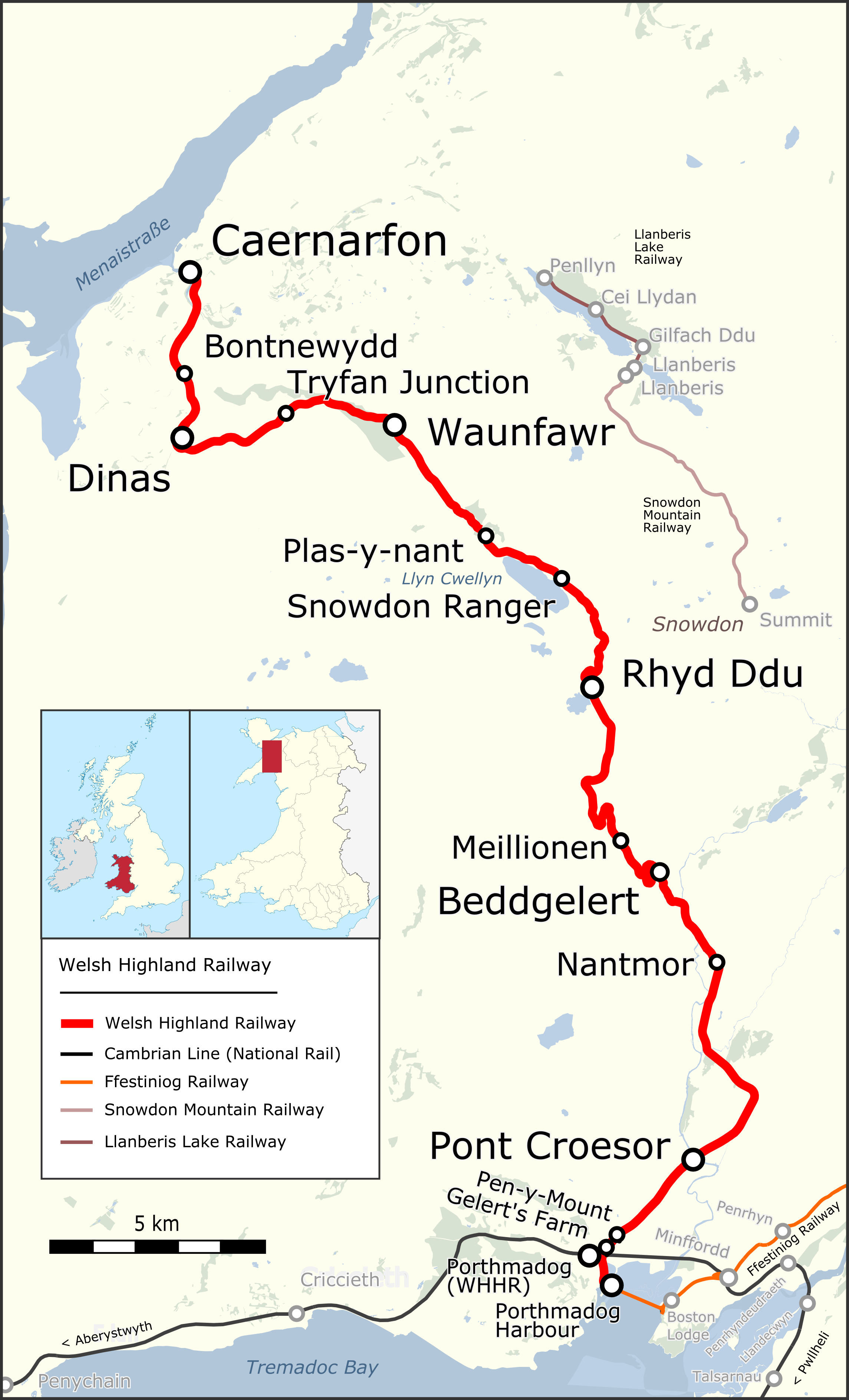
The Welsh Highland Railway (WHR) or Rheilffordd Eryri is a long, restored narrow gauge heritage railway in the Welsh county of Gwynedd, operating from Caernarfon to Porthmadog, and passing through a number of popular tourist destinations including Beddgelert and the Aberglaslyn Pass. At Porthmadog it connects with the Ffestiniog Railway and to the short Welsh Highland Heritage Railway. In Porthmadog it uses the United Kingdom's only mixed gauge flat rail crossing. The restoration, which had the civil engineering mainly built by contractors and the track mainly built by volunteers, received a number of awards. Originally running from , near Caernarfon, to ,Boyd (1972), pages=283 the current line includes an additional section from Dinas to Caernarfon. The original line also had a branch to and the slate quarries around Moel Tryfan, which has not been restored. (This branch forms a footpath "rail trail", the lower section of which has been resurfaced and supplied with h ... [...More Info...] [...Related Items...] OR: [Wikipedia] [Google] [Baidu] |
Portmadoc, Beddgelert And South Snowdon Railway
The Porthmadog, Beddgelert and South Snowdon Railway (PB&SSR) was a narrow gauge railway intended to connect Porthmadog with the North Wales Narrow Gauge Railways link terminus at Rhyd Ddu. Although some of the line was constructed between 1901 and 1906, it never opened and eventually became part of the Welsh Highland Railway. History There were several attempts by the North Wales Power and Traction Company to promote lines between Portmadoc and Beddgelert with extensions at either end. These culminated in a proposal in 1901, for a narrow gauge electric railway to use three phase alternating current at about 630 volts using the system devised by Ganz of Budapest. Proposed route The PB&SSR would have run from the western end of Black Rock sands via Morfa Bychan, Borth y gest, Portmadoc and, using part of the Croesor Tramway, to Beddgelert to link with the South Snowdon Quarries (hence the title) in the Gwynant Valley. There was no intention initially to connect with the ... [...More Info...] [...Related Items...] OR: [Wikipedia] [Google] [Baidu] |
Toll Road
A toll road, also known as a turnpike or tollway, is a public or private road (almost always a controlled-access highway in the present day) for which a fee (or '' toll'') is assessed for passage. It is a form of road pricing typically implemented to help recoup the costs of road construction and maintenance. Toll roads have existed in some form since antiquity, with tolls levied on passing travelers on foot, wagon, or horseback; a practice that continued with the automobile, and many modern tollways charge fees for motor vehicles exclusively. The amount of the toll usually varies by vehicle type, weight, or number of axles, with freight trucks often charged higher rates than cars. Tolls are often collected at toll plazas, toll booths, toll houses, toll stations, toll bars, toll barriers, or toll gates. Some toll collection points are automatic, and the user deposits money in a machine which opens the gate once the correct toll has been paid. To cut costs and minimise tim ... [...More Info...] [...Related Items...] OR: [Wikipedia] [Google] [Baidu] |
Ffestiniog Railway
The Ffestiniog Railway ( cy, Rheilffordd Ffestiniog) is a heritage railway based on narrow-gauge, located in Gwynedd, Wales. It is a major tourist attraction located mainly within the Snowdonia National Park. The railway is roughly long and runs from the harbour at Porthmadog to the slate mining town of Blaenau Ffestiniog, travelling through forested and mountainous terrain. The line is single track throughout with four intermediate passing places. The first mile of the line out of Porthmadog runs atop an embankment called ''the Cob'', which is the dyke of the polder known as Traeth Mawr. The Festiniog Railway Company, which owns the railway, is the oldest surviving railway company in the world. It also owns the Welsh Highland Railway, which was re-opened fully in 2011. The two railways share the same track gauge and meet at Porthmadog station, with occasional trains working the entire route from Blaenau Ffestiniog to Caernarfon. History The railway company is prope ... [...More Info...] [...Related Items...] OR: [Wikipedia] [Google] [Baidu] |
Pont Aberglaslyn
Pont Aberglaslyn is a stone arch bridge over the Afon Glaslyn and the surrounding hamlet, located near Beddgelert and Nantmor in Gwynedd, north-west Wales. A well-known beauty spot, according to Peter Bishop it was "one of the most visited sites in north Wales" at the end of the eighteenth century; an 1883 guidebook wrote that it "has occupied the artist's pencil perhaps more than any other". Location Pont Aberglaslyn is located near the downstream end of the Aberglaslyn Pass. While the location is rocky with the river running through rapids just upstream, it is not far above sea level. The river was tidal and navigable up to around Pont Aberglaslyn until the early nineteenth century, when the construction of the Cob seawall near Porthmadog prevented the tide from reaching it. Below the bridge is Llyn Glas (Blue Lake), a former harbour site used for loading copper mined nearby. The bridge was formerly on the border between Caernarfonshire on the west side of the river and Mer ... [...More Info...] [...Related Items...] OR: [Wikipedia] [Google] [Baidu] |
Open Top Bus
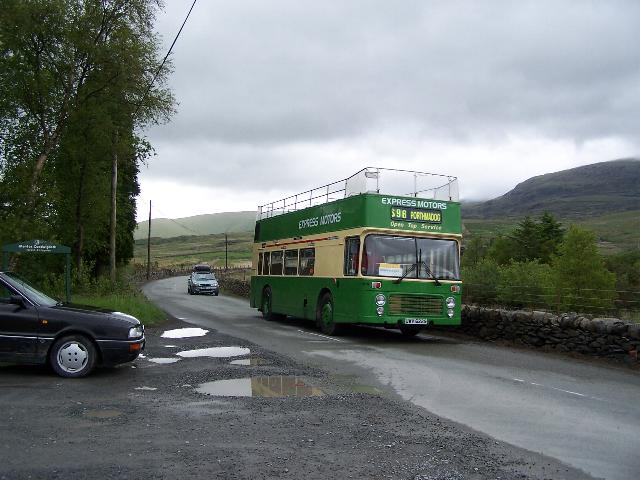
An open top bus is a bus, usually but not exclusively a double-decker bus, which has been built or modified to operate without a roof. Early buses were constructed without roofs but in more recent times they have only been built for tourist and sightseeing services. Some are made by removing all or part of the roof from a more conventional bus. Use Until the 1920s most, if not all, double-decker buses were constructed with no roof on the upper deck, and were the original "open-toppers". Open-top buses are now primarily used as tour buses for sightseeing in cities, or around rural monuments or areas of special interest. These often include specialist information equipment, and colourful liveries illustrating the route. Open-top buses are used in some regions on regular public transport transit bus services, in warm climates, or as seasonal services in temperate climates. Seasonal services are often in seaside towns, or along rural or coastal routes of particular scenic qualit ... [...More Info...] [...Related Items...] OR: [Wikipedia] [Google] [Baidu] |
A498 Road
The A498 is a 16-mile road between Pen-y-Gwryd and Porthmadog in North Wales. At Pen-y-Gwryd, the A4086 Llanberis Pass route bears off to the north. The A498 descends from a 277 m (909 ft.) summit at Pen-y-Gwryd and runs south west through the village of Beddgelert and the Aberglaslyn Pass, where it overlaps the A4085. The A498 then passes through Tremadog, overlapping the A487 for a short length before passing under the Cambrian Coast railway and terminating at Penamser on the A497 about a mile west of Porthmadog. At its northern end, the road forms a link via the A4086 with the A5 at Capel Curig, forming a useful holiday route to the Beddgelert/Porthmadog area. At the junctions, the A4086 to Llanberis is the minor road at Pen-y-Gwryd, while the A498 is the minor road at Beddgelert. At Pont Aberglaslyn, the A4085 is the minor road diverging to Penrhyndeudraeth and at Tremadog, the A498 is the major road. The junction west of Tremadog is a roundabout and at ... [...More Info...] [...Related Items...] OR: [Wikipedia] [Google] [Baidu] |
Pitt's Head
Pitt's Head (Welsh: Carreg Collwyn) is a distinctive rock located at grid reference , close to the A4085 road in Gwynedd, Wales. Its distinction lies in a resemblance to the profile of politician William Pitt the Younger. Geography Located as it is near the base of one of the paths to the summit of Snowdon, Pitt's Head Halt was a station on the original Welsh Highland Railway, also marking the highest point on that railway. The present reconstruction of the railway does not envisage reopening the halt. The rock gives its name to the Pitt's Head Bridge, where the railway passes under the A4085, and the nearby Pitt's Head Cutting. In the geology of the region, the rock gives its name to the rock of which it is formed, the Pitt's Head Tuff. This is an Ordovician acid ash-flow tuff which outcrops on the northern flanks of Snowdonia. The correct name for this rock cluster is Cerrig Collwyn, Pitt's Head is only a name for one of these rocks. Collwyn ap Tango was said to be Lord ... [...More Info...] [...Related Items...] OR: [Wikipedia] [Google] [Baidu] |
Rhyd Ddu
Rhyd-ddu ( Welsh for 'black ford') is a small village in Snowdonia, North Wales which is a starting point for walks up Snowdon (via the Rhyd Ddu Path), Moel Hebog, Yr Aran and the Nantlle Ridge. It lies on the A4085 between Beddgelert and Caernarfon, at its junction with the B4418 to Nantlle and Penygroes. Rhyd Ddu railway station is one of the stops on the Welsh Highland Railway between Caernarfon and Porthmadog. T. H. Parry-Williams, the poet, author and academic was born and raised at Rhyd-ddu. He twice won both the Chair and the Crown at the National Eisteddfod The National Eisteddfod of Wales ( Welsh: ') is the largest of several eisteddfodau that are held annually, mostly in Wales. Its eight days of competitions and performances are considered the largest music and poetry festival in Europe. Competitor ..., in 1912 and 1915. External links Walks from Rhyd Ddu and local information [...More Info...] [...Related Items...] OR: [Wikipedia] [Google] [Baidu] |
Llyn Cwellyn
Llyn Cwellyn (''Llyn Quellyn'' in some antiquated texts) is a reservoir in North Wales which supplies drinking water to parts of Gwynedd and Anglesey. It lies on the Afon Gwyrfai in Nant y Betws between Moel Eilio and Mynydd Mawr in the northern part of Snowdonia National Park. It has an area of , and is over deep. At the southern end is the small village of Rhyd Ddu. Although it is now dammed at the northern end, below the Castell Cidwm ridge, near the village of Betws Garmon this has not substantially increased the size of the natural glacial moraine lake that has existed since the last ice age. The lake is very deep and is one of the few lakes in Wales to support a natural population of Arctic char. The lake also is home to brown trout and there are otters that are regularly seen at the Castell Cidwm end. The lake has shared ownership between Lawrence Jones (businessman) owner of the Castell Cidwm estate at the Northern end and Welsh water, who own the right hand side tha ... [...More Info...] [...Related Items...] OR: [Wikipedia] [Google] [Baidu] |
Snowdon
Snowdon () or (), is the highest mountain in Wales, at an elevation of above sea level, and the highest point in the British Isles outside the Scottish Highlands. It is located in Snowdonia National Park (') in Gwynedd (historic county of Caernarfonshire). On 17 November 2022, the Snowdonia National Park Authority announced they are to use the Welsh name ''Yr Wyddfa'' for ''Snowdon'' and ''Eryri'' for ''Snowdonia'' in all circumstances and capacities, in English and Welsh. It is the busiest mountain in the United Kingdom and the third most visited attraction in Wales; in 2019 it was visited by 590,984 walkers, with an additional 140,000 people taking the train. It is designated as a national nature reserve for its rare flora and fauna. The rocks that form Snowdon were produced by volcanoes in the Ordovician period, and the massif has been extensively sculpted by glaciation, forming the pyramidal peak of Snowdon and the arêtes of Crib Goch and Y Lliwedd. ... [...More Info...] [...Related Items...] OR: [Wikipedia] [Google] [Baidu] |


