|
Aspenden
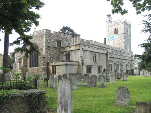
Aspenden is a village and civil parish in the East Hertfordshire district of Hertfordshire, England. It is just to the south of Buntingford. The Prime Meridian passes just to the east of it. Its name, which means 'valley of aspen trees', was first attested in 1212. See also * The Hundred Parishes The Hundred Parishes is a cultural heritage initiative focused on an area in the East of England recognized for its high concentration of cultural and historical significance. Although without formal recognition or status, the concept has the ble ... References External links * Aspenden (''A Guide to Old Hertfordshire'')* Villages in Hertfordshire Civil parishes in Hertfordshire East Hertfordshire District {{Hertfordshire-geo-stub ... [...More Info...] [...Related Items...] OR: [Wikipedia] [Google] [Baidu] |
Civil Parishes In Hertfordshire
This is a list of civil parishes in England, civil parishes in the ceremonial county of Hertfordshire, England. There are 128 civil parishes. List of civil parishes and unparished areas See also * List of civil parishes in England * List of settlements in Hertfordshire by population * The Hundred Parishes, a grouping of parishes in East and North Herts, NW Essex and southern Cambridgeshire References External links Office for National Statistics : Geographical Area Listings {{Hertfordshire Populated places in Hertfordshire, Civil parishes Lists of civil parishes in England, Hertfordshire Civil parishes in Hertfordshire, ... [...More Info...] [...Related Items...] OR: [Wikipedia] [Google] [Baidu] |
The Hundred Parishes
The Hundred Parishes is a cultural heritage initiative focused on an area in the East of England recognized for its high concentration of cultural and historical significance. Although without formal recognition or status, the concept has the blessing of county and district authorities. It encompasses around 450 square miles (1,100 square kilometres) of northwest Essex, northeast Hertfordshire and southern Cambridgeshire. The area comprises just over 100 administrative parishes, hence its name. It contains over 6,000 listed buildings and many Conservation area (United Kingdom), conservation areas, village greens, ancient hedgerows, protected features and a historical pattern of small rural settlements in close proximity to one another. Origins The idea of recognising the area for its special heritage characteristics was originally conceived by local historian and author David Heathcote. A steering group of local historians, conservationists and a local authority representativ ... [...More Info...] [...Related Items...] OR: [Wikipedia] [Google] [Baidu] |
East Hertfordshire
East Hertfordshire is one of ten Non-metropolitan district, local government districts in Hertfordshire, England. Its council is based in Hertford, the county town of Hertfordshire. The largest town in the district is Bishop's Stortford, and the other main towns are Ware, Hertfordshire, Ware, Buntingford and Sawbridgeworth. At the 2011 United Kingdom census, 2011 Census, the population of the district was 137,687. By area it is the largest of the ten local government districts in Hertfordshire. The district borders North Hertfordshire, Stevenage, Welwyn Hatfield and Borough of Broxbourne, Broxbourne in Hertfordshire, and Epping Forest District, Epping Forest, Harlow and Uttlesford in Essex. In the 2006 edition of Channel 4's "Best and Worst Places to Live in the UK", East Hertfordshire was rated the seventh-best district to live in. In 2012, East Hertfordshire came ninth in Halifax (bank), Halifax bank's annual survey of most desirable places to live. It came first in this surve ... [...More Info...] [...Related Items...] OR: [Wikipedia] [Google] [Baidu] |
Hertfordshire
Hertfordshire ( or ; often abbreviated Herts) is a ceremonial county in the East of England and one of the home counties. It borders Bedfordshire to the north-west, Cambridgeshire to the north-east, Essex to the east, Greater London to the south and Buckinghamshire to the west. The largest settlement is Watford, and the county town is Hertford. The county has an area of and had a population of 1,198,800 at the 2021 census. After Watford (131,325), the largest settlements are Hemel Hempstead (95,985), Stevenage (94,470) and the city of St Albans (75,540). For local government purposes Hertfordshire is a non-metropolitan county with ten districts beneath Hertfordshire County Council. Elevations are higher in the north and west, reaching more than in the Chilterns near Tring. The county centres on the headwaters and upper valleys of the rivers Lea and the Colne; both flow south and each is accompanied by a canal. Hertfordshire's undeveloped land is mainly agricultural ... [...More Info...] [...Related Items...] OR: [Wikipedia] [Google] [Baidu] |
North East Hertfordshire (UK Parliament Constituency)
North is one of the four compass points or cardinal directions. It is the opposite of south and is perpendicular to east and west. ''North'' is a noun, adjective, or adverb indicating direction or geography. Etymology The word ''north'' is related to the Old High German ''nord'', both descending from the Proto-Indo-European unit *''ner-'', meaning "left; below" as north is to left when facing the rising sun. Similarly, the other cardinal directions are also related to the sun's position. The Latin word ''borealis'' comes from the Greek ''boreas'' "north wind, north" which, according to Ovid, was personified as the wind-god Boreas, the father of Calais and Zetes. ''Septentrionalis'' is from ''septentriones'', "the seven plow oxen", a name of '' Ursa Major''. The Greek ἀρκτικός (''arktikós'') is named for the same constellation, and is the source of the English word ''Arctic''. Other languages have other derivations. For example, in Lezgian, ''kefer'' can m ... [...More Info...] [...Related Items...] OR: [Wikipedia] [Google] [Baidu] |
Civil Parish
In England, a civil parish is a type of administrative parish used for local government. It is a territorial designation which is the lowest tier of local government. Civil parishes can trace their origin to the ancient system of parishes, which for centuries were the principal unit of secular and religious administration in most of England and Wales. Civil and religious parishes were formally split into two types in the 19th century and are now entirely separate. Civil parishes in their modern form came into being through the Local Government Act 1894 ( 56 & 57 Vict. c. 73), which established elected parish councils to take on the secular functions of the parish vestry. A civil parish can range in size from a sparsely populated rural area with fewer than a hundred inhabitants, to a large town with a population in excess of 100,000. This scope is similar to that of municipalities in continental Europe, such as the communes of France. However, unlike their continental Euro ... [...More Info...] [...Related Items...] OR: [Wikipedia] [Google] [Baidu] |
Buntingford
Buntingford is a market town and civil parishes in England, civil parish in the district of East Hertfordshire and county of Hertfordshire in England. It lies next to the River Rib and is located on the historic Roman road, Ermine Street. As a result of its location, it grew mainly as a staging post with many coaching inns and has an 18th-century one-cell prison known as The Cage, by the Ford (crossing), ford at the end of Church Street. It has a population of 7,879, as of the 2021 UK census. Name Despite popular belief, the name of Buntingford does not come from the Emberiza, bunting bird. Instead, it probably originates from the Saxon chieftain or tribe Bunta and the local ford running over the River Rib. Buntingford was the name of the ford and its surrounding areas, with Bunting being the name of a village located six miles to its north, which is translated from Old English as "place or people of Bunta". The earliest forms of the name Buntingford are ''Buntas Ford'' and ... [...More Info...] [...Related Items...] OR: [Wikipedia] [Google] [Baidu] |
Prime Meridian
A prime meridian is an arbitrarily chosen meridian (geography), meridian (a line of longitude) in a geographic coordinate system at which longitude is defined to be 0°. On a spheroid, a prime meridian and its anti-meridian (the 180th meridian in a degree (angle), 360°-system) form a great ellipse. This divides the body (e.g. Earth) into hemispheres of Earth, two hemispheres: the Eastern Hemisphere and the Western Hemisphere (for an east-west notational system). For Earth's prime meridian, various conventions have been used or advocated in different regions throughout history. Earth's current international standard prime meridian is the IERS Reference Meridian. It is derived, but differs slightly, from the Prime meridian (Greenwich), Greenwich Meridian, the previous standard. Longitudes for the Earth and Moon are measured from their prime meridian (at 0°) to 180° east and west. For all other Solar System bodies, longitude is measured from 0° (their prime meridian) to 360� ... [...More Info...] [...Related Items...] OR: [Wikipedia] [Google] [Baidu] |
Villages In Hertfordshire
A village is a human settlement or Residential community, community, larger than a hamlet (place), hamlet but smaller than a town with a population typically ranging from a few hundred to a few thousand. Although villages are often located in rural areas, the term urban village is also applied to certain urban neighborhoods. Villages are normally permanent, with fixed dwellings; however, transient villages can occur. Further, the dwellings of a village are fairly close to one another, not scattered broadly over the landscape, as a dispersed settlement. In the past, villages were a usual form of community for societies that practice subsistence agriculture and also for some non-agricultural societies. In Great Britain, a hamlet earned the right to be called a village when it built a Church (building), church. [...More Info...] [...Related Items...] OR: [Wikipedia] [Google] [Baidu] |


