|
Altocumulus Stratiformis
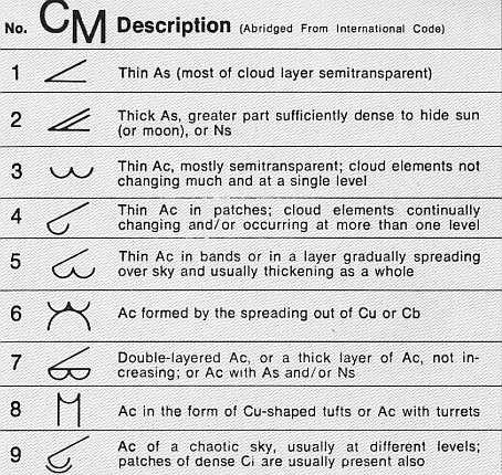
Altocumulus stratiformis is the most common species of the Altocumulus genus of clouds. They tend to form broad layers of individual, cell-like clumps, often separated from each other, though they sometimes can coagulate into a larger individual cloud. They often have a vertical extent of less than 500 m. Due to their formation dynamics, they are commonly associated with the imminent arrival of precipitation. Formation The presence of stratiformis clouds in the mid-levels of the atmosphere is indicative of some instability at that level; atmospheric pressure falls, often associated with nearby systems of low pressure, can depress the altitude of stratiformis into the lower atmosphere, often evolving into Nimbostratus A nimbostratus cloud is a multi-level, amorphous, nearly uniform and often dark grey cloud that usually produces continuous rain, snow or sleet but no lightning or thunder. [...More Info...] [...Related Items...] OR: [Wikipedia] [Google] [Baidu] |
Altocumulus
Altocumulus (From Latin ''Altus'', "high", ''cumulus'', "heaped") is a middle-altitude cloud genus that belongs mainly to the ''stratocumuliform'' physical category characterized by globular masses or rolls in layers or patches, the individual elements being larger and darker than those of cirrocumulus and smaller than those of stratocumulus. However, if the layers become tufted in appearance due to increased airmass instability, then the altocumulus clouds become more purely ''cumuliform'' in structure. Like other cumuliform and stratocumuliform clouds, altocumulus signifies convection. A sheet of partially conjoined altocumulus perlucidus is sometimes found preceding a weakening warm front, where the altostratus is starting to fragment, resulting in patches of altocumulus perlucidus between the areas of altostratus. Altocumulus is also commonly found between the warm and cold fronts in a depression, although this is often hidden by lower clouds. Towering altocumulus, known as ... [...More Info...] [...Related Items...] OR: [Wikipedia] [Google] [Baidu] |
Pressure Drop
Pressure drop is defined as the difference in total pressure between two points of a fluid carrying network. A pressure drop occurs when frictional forces, caused by the resistance to flow, act on a fluid as it flows through the tube. The main determinants of resistance to fluid flow are fluid velocity through the pipe and fluid viscosity The viscosity of a fluid is a measure of its resistance to deformation at a given rate. For liquids, it corresponds to the informal concept of "thickness": for example, syrup has a higher viscosity than water. Viscosity quantifies the inte .... Pressure drop increases proportionally to the frictional shear forces within the piping network. A piping network containing a high relative roughness rating as well as many pipe fittings and joints, tube convergence, divergence, turns, surface roughness, and other physical properties will affect the pressure drop. High flow velocities and/or high fluid viscosities result in a larger pressure ... [...More Info...] [...Related Items...] OR: [Wikipedia] [Google] [Baidu] |
Nimbostratus
A nimbostratus cloud is a multi-level, amorphous, nearly uniform and often dark grey cloud that usually produces continuous rain, snow or sleet but no lightning or thunder. in the Oxford Dictionaries Online Although it is usually a low-based cloud, it actually forms most commonly in the middle level of the troposphere and then spreads vertically into the low and high levels. Nimbostratus usually produces precipitation over a wide area. ''Nimbo-'' is from the Latin word ''nimbus'', which denotes cloud or halo. Downward-growing nimbostratus can have the same vertical extent as most large upward-growing cumulus, but its horizontal extent tends to be even greater. Appearance Nimbostratus has a diffuse |
