|
Agulhas Bank Complex Marine Protected Area
The Agulhas Bank Complex Marine Protected Area is an offshore marine protected area on the continental shelf lying approximately 39 nautical miles southeast of Cape Agulhas off the Western Cape in the Exclusive Economic Zone of South Africa. History The MPA was proclaimed by the Minister of Environmental Affairs, in terms of sections 48A(2) and 86(1)(a), (b), (c) and (d) of the National Environmental Management: Protected Areas Act, 57 of 2003. Purpose A marine protected area (MPA) is defined by the IUCN as "A clearly defined geographical space, recognised, dedicated and managed, through legal or other effective means, to achieve the long-term conservation of nature with associated ecosystem services and cultural values". The Agulhas banks have supported economically important fisheries for more than a century. This MPA is intended to protect spawning aggregations of several economically important fish, including the endangered Red steenbras, the largest seabream, a long liv ... [...More Info...] [...Related Items...] OR: [Wikipedia] [Google] [Baidu] |
Agulhas Bank
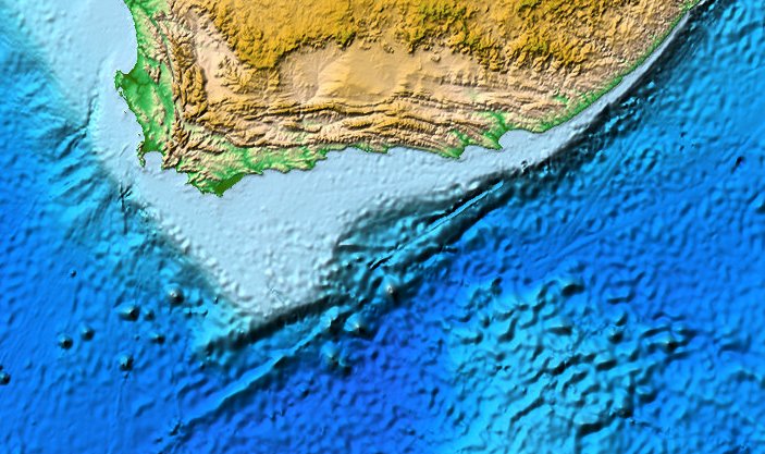
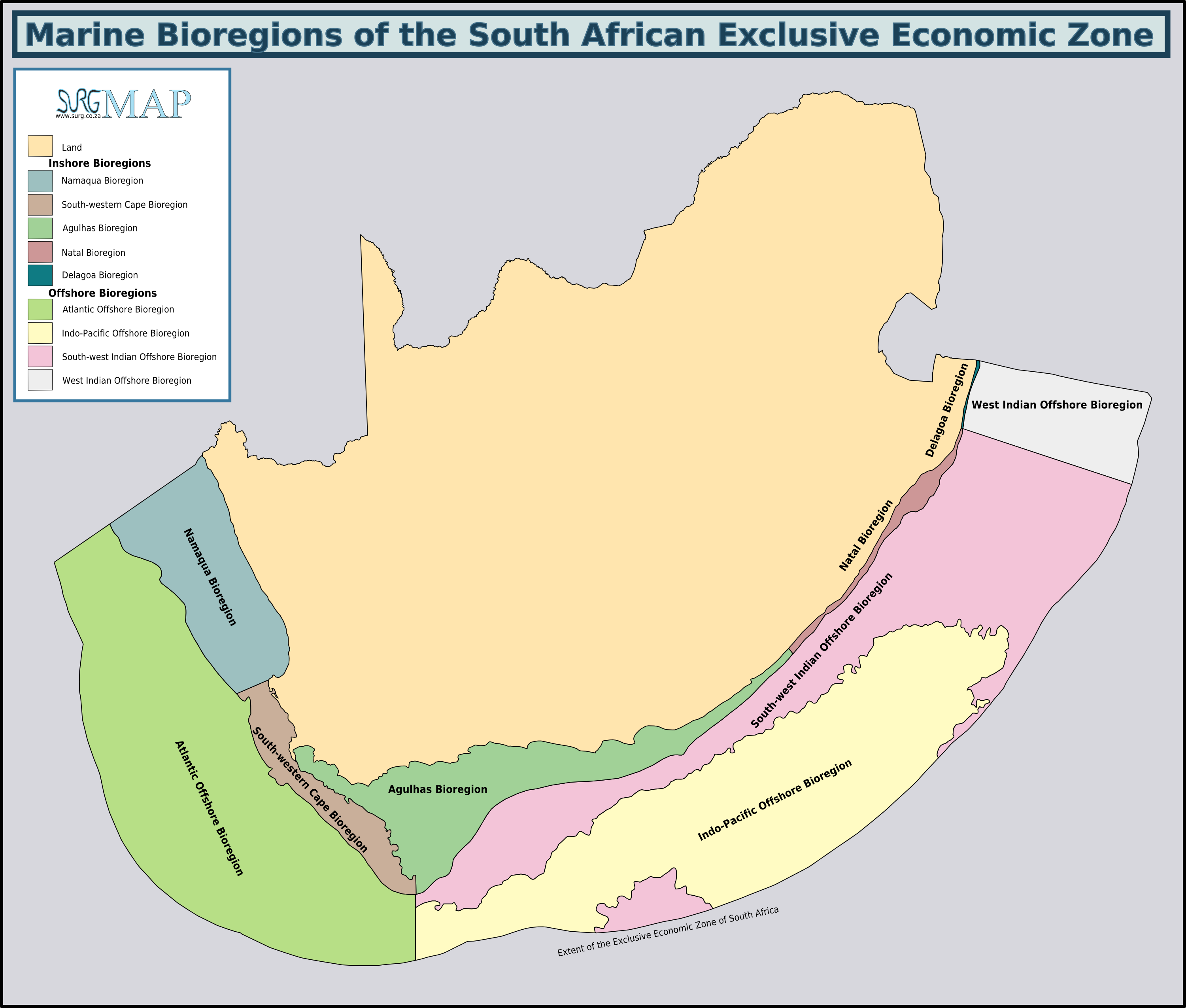
The Agulhas Bank (, from Portuguese for Cape Agulhas, ''Cabo das Agulhas'', "Cape of Needles") is a broad, shallow part of the southern African continental shelf which extends up to south of Cape Agulhas before falling steeply to the abyssal plain. It is the ocean region where the warm Indian Ocean and the cold Atlantic Ocean meet. This convergence leads to treacherous sailing conditions, accounting for numerous wrecked ships in the area over the years. However, the meeting of the oceans here also fuels the nutrient cycle for marine life, making it one of the best Fishing bank, fishing grounds in South Africa. Extent and characteristics file:Ecoregions of SA EEZ.png, South African marine ecoregions from the 2011 classification The Agulhas Bank stretches approximately along the African coast, from off Cape Peninsula (18°E) to Port Alfred (26°E), and up to from it. The bank slopes down relatively steeply from the coast to about deep and reaches before dropping steeply t ... [...More Info...] [...Related Items...] OR: [Wikipedia] [Google] [Baidu] |
Abyssal Plain
An abyssal plain is an underwater plain on the deep ocean floor, usually found at depths between . Lying generally between the foot of a continental rise and a mid-ocean ridge, abyssal plains cover more than 50% of the Earth's surface. They are among the flattest, smoothest, and least explored regions on Earth. Abyssal plains are key geologic elements of oceanic basins, the other elements being an elevated mid-ocean ridge and flanking abyssal hills. The creation of the abyssal plain is the result of the spreading of the seafloor (plate tectonics) and the melting of the lower oceanic crust. Magma rises from above the asthenosphere (a layer of the upper mantle), and as this basaltic material reaches the surface at mid-ocean ridges, it forms new oceanic crust, which is constantly pulled sideways by spreading of the seafloor. Abyssal plains result from the blanketing of an originally uneven surface of oceanic crust by fine-grained sediments, mainly clay and silt. Much of th ... [...More Info...] [...Related Items...] OR: [Wikipedia] [Google] [Baidu] |
Sverdrup
In oceanography, the sverdrup (symbol: Sv) is a non- SI metric unit of volumetric flow rate, with equal to . It is equivalent to the SI derived unit cubic hectometer per second (symbol: hm3/s or hm3⋅s−1): is equal to . It is used almost exclusively in oceanography to measure the volumetric rate of transport of ocean currents. It is named after Harald Sverdrup. One sverdrup is about five times what is carried at the estuary by the world's largest river, the Amazon. In the context of ocean currents, a volume of one million cubic meters may be imagined as a "slice" of ocean with dimensions × × (width × length × thickness) or a cube with dimensions × × . At this scale, these units can be more easily compared in terms of width of the current (several km), depth (hundreds of meters), and current speed (as meters per second). Thus, a hypothetical current wide, (m) deep, and moving at would be transporting of water. The sverdrup is distinct from the SI siever ... [...More Info...] [...Related Items...] OR: [Wikipedia] [Google] [Baidu] |
World Ocean
The ocean is the body of salt water that covers approximately 70.8% of Earth. The ocean is conventionally divided into large bodies of water, which are also referred to as ''oceans'' (the Pacific, Atlantic, Indian, Antarctic/Southern, and Arctic Ocean),"Ocean." ''Merriam-Webster.com Dictionary'', Merriam-Webster, https://www.merriam-webster.com/dictionary/ocean . Accessed March 14, 2021. and are themselves mostly divided into seas, gulfs and subsequent bodies of water. The ocean contains 97% of [...More Info...] [...Related Items...] OR: [Wikipedia] [Google] [Baidu] |
Western Boundary Current
Boundary currents are ocean currents with dynamics determined by the presence of a coastline, and fall into two distinct categories: western boundary currents and eastern boundary currents. Eastern boundary currents Eastern boundary currents are relatively shallow, broad and slow-flowing. They are found on the eastern side of oceanic basins (adjacent to the western coasts of continents). Subtropical eastern boundary currents flow equatorward, transporting cold water from higher latitudes to lower latitudes; examples include the Benguela Current, the Canary Current, the Humboldt (Peru) Current, and the California Current. Coastal upwelling often brings nutrient-rich water into eastern boundary current regions, making them productive areas of the ocean. Western boundary currents Western boundary currents may themselves be divided into sub-tropical or low-latitude western boundary currents. Sub-tropical western boundary currents are warm, deep, narrow, and fast-flowing currents ... [...More Info...] [...Related Items...] OR: [Wikipedia] [Google] [Baidu] |
Benguela And Agulhas Currents
Benguela (; Umbundu: Luombaka) is a city in western Angola, capital of Benguela Province. Benguela is one of Angola's most populous cities with a population of 555,124 in the city and 561,775 in the municipality, at the 2014 census. History Portuguese rule Benguela was founded in 1617 as ''São Felipe de Benguela'' by the Portugal, Portuguese under Manuel Cerveira Pereira, 8th Governor of Portuguese West Africa, Angola (1604–1607). It was long the centre of an important trade, especially in Slavery in Angola, slaves to Brazil and Cuba. Ships anchored about off the shore, in depths of and Lightering, transferred loads to smaller boats which used five or six jetty, jetties in the town. However, the nearby deep-water sheltered harbour of Lobito was a much larger port. Besides the churches of S. Felipe and S. António, the hospital, and the fortress, as of 1911 there were only a few stone-built houses. A short way beyond Benguela is Baía Farta, where salt was manufactured ... [...More Info...] [...Related Items...] OR: [Wikipedia] [Google] [Baidu] |


