|
─Ćraiteuru
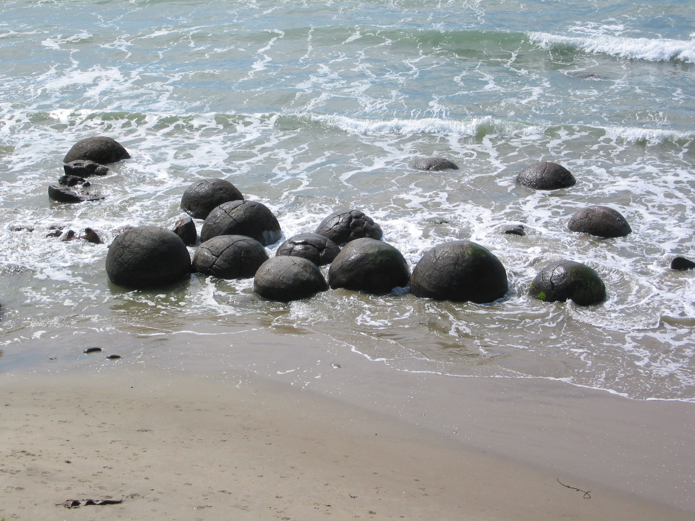
(also written ) was a canoe () of some of Ng─üi Tahu's ancestors in M─üori tradition. The canoe was conveyed to New Zealand by the north-east wind, carrying the chiefs Kirikirikatata, Aroarokaehe, Mauka Atua, Aoraki, Kakeroa, Te Horokoatu, Ritua, Ngamautaurua, Pokohiwitahi, Puketapu, Te Maro-tiri-a-te-rehu, Hikuroroa, Pahatea, Te Waioteao, and Hapekituaraki. The canoe's fishing net and the water gourd (calabash) were turned into stone at Moeraki in the South Island, where they can still be seen in the form of the Moeraki Boulders. The canoe itself remained at Shag Point. Dunedin's pan- ─Ćrai Te Uru Marae, located in the suburb of Wakari, is named after the canoe. See also * Arahura (canoe) * T─ükitimu ''T─ükitimu'' was a ''waka (canoe), waka'' (canoe) with ''whakapapa'' throughout the Pacific Ocean, Pacific particularly with Samoa, the Cook Islands, and New Zealand in ancient times. In several M─üori mythology, M─üori traditions, the ''T─ük ... * Uruaokapuar ... [...More Info...] [...Related Items...] OR: [Wikipedia] [Google] [Baidu] |
Dunedin
Dunedin ( ; ) is the second-most populous city in the South Island of New Zealand (after Christchurch), and the principal city of the Otago region. Its name comes from ("fort of Edin"), the Scottish Gaelic name for Edinburgh, the capital of Scotland. The city has a rich M─üori people, M─üori, Scottish people, Scottish, and Chinese people, Chinese heritage. With an estimated population of as of , Dunedin is New Zealand's seventh-most populous metropolitan and urban area. For cultural, geographical, and historical reasons, the city has long been considered one of New Zealand's four main centres. The urban area of Dunedin lies on the central-eastern coast of Otago, surrounding the head of Otago Harbour. The harbour and hills around Dunedin are the remnants of an extinct volcano. The city suburbs extend out into the surrounding valleys and hills, onto the isthmus of the Otago Peninsula, and along the shores of the Otago Harbour and the Pacific Ocean. Archaeological evidence poin ... [...More Info...] [...Related Items...] OR: [Wikipedia] [Google] [Baidu] |
M─üori Migration Canoes
M─üori oral histories recount how their ancestors set out from their homeland in ''waka hourua'', large twin-hulled ocean-going canoes ('' waka''). Some of these traditions name a homeland called Hawaiki. Among these is the story of Kupe, who had eloped with K┼½r─ümarotini, the wife of Hoturapa, the owner of the great canoe '' Matahourua'', whom Kupe had murdered. To escape punishment for the murder, Kupe and Kura fled in Matahourua and discovered a land he called Aotearoa ('land of the long-white-cloud'). He explored its coast and killed the sea monster Te Wheke-a-Muturangi, finally returning to his home to spread the news of his newly discovered land. Other stories of various M─üori tribes report migrations to escape famine, over-population, and warfare. These were made in legendary canoes, the best known of which are '' Aotea'', ''Te Arawa'', '' Kurahaup┼Ź'', '' M─ütaatua'', '' Tainui'', '' T─ükitimu'', and '' Tokomaru''. Various traditions name numerous other cano ... [...More Info...] [...Related Items...] OR: [Wikipedia] [Google] [Baidu] |
M─üori Mythology
M─üori mythology and M─üori traditions are two major categories into which the remote oral history of New Zealand's M─üori people, M─üori may be divided. M─üori myths concern tales of supernatural events relating to the origins of what was the observable world for the pre-European M─üori, often involving gods and demigods. M─üori tradition concerns more folkloric legends often involving historical or semi-historical forebears. Both categories merge in to explain the overall origin of the M─üori and their connections to the world which they lived in. The M─üori did not have a writing system before European contact, beginning in 1769, therefore they relied on oral retellings and recitations memorised from generation to generation. The three forms of expression prominent in M─üori and Polynesian oral literature are genealogical recital, poetry, and narrative prose. Experts in these subjects were broadly known as . The rituals, beliefs, and general worldview of M─üori society were ... [...More Info...] [...Related Items...] OR: [Wikipedia] [Google] [Baidu] |
Arahura (canoe)
was a divine canoe () made of pounamu in Ng─üi Tahu's M─üori mythology. The chiefs who travelled to New Zealand in her were Peki(te)tahua, Rongokahe, Rangitatau, Hineraho, Te Rangitamau, Taewhenua, Te Mikimiki (Te Mingimingi), Atua-whakanihoniho, Te Atua-whakataratara, and Whakarewa. may have also been the name of the that was brought along with the canoe. References See also * ─Ćraiteuru * Ngahue * T─ükitimu ''T─ükitimu'' was a ''waka (canoe), waka'' (canoe) with ''whakapapa'' throughout the Pacific Ocean, Pacific particularly with Samoa, the Cook Islands, and New Zealand in ancient times. In several M─üori mythology, M─üori traditions, the ''T─ük ... * Uruaokapuarangi M─üori waka M─üori mythology {{M─üori-myth-stub ... [...More Info...] [...Related Items...] OR: [Wikipedia] [Google] [Baidu] |
Ng─üi Tahu
Ng─üi Tahu, or K─üi Tahu, is the principal M─üori people, M─üori (tribe) of the South Island. Its (tribal area) is the largest in New Zealand, and extends from the White Bluffs / Te Parinui o Whiti (southeast of Blenheim, New Zealand, Blenheim), Mount M─ühanga and Kahurangi Point in the north to Stewart Island / Rakiura in the south. The comprises 18 (governance areas) corresponding to traditional settlements. According to the 2023 New Zealand census, 2023 census an estimated 84,000 people affiliated with the K─üi Tahu iwi. Ng─üi Tahu originated in the Gisborne District of the North Island, along with Ng─üti Porou and Ng─üti Kahungunu, who all intermarried amongst the local Ng─üti Ira. Over time, all but Ng─üti Porou would migrate away from the district. Several were already occupying the South Island prior to Ng─üi Tahu's arrival, with K─üti M─ümoe only having arrived about a century earlier from the Hastings, New Zealand, Hastings District, and already having conquered W ... [...More Info...] [...Related Items...] OR: [Wikipedia] [Google] [Baidu] |
Moeraki Boulders
The Moeraki Boulders (officially Moeraki Boulders / Kaihinaki) are unusually large spherical boulders lying along a stretch of Koekohe Beach on the wave-cut Otago coast of New Zealand between Moeraki and Hampden. They occur scattered either as isolated or clusters of boulders within a stretch of beach where they have been protected in a scientific reserve. These boulders are grey-coloured septarian concretions, which have been exhumed from the mudstone and bedrock enclosing them and concentrated on the beach by coastal erosion.Boles, J. R., C. A. Landis, and P. Dale, 1985''The Moeraki Boulders; anatomy of some septarian concretions'' Journal of Sedimentary Petrology, vol. 55, n. 3, p. 398-406.Fordyce, E., and P. Maxwell, 2003, ''Canterbury Basin Paleontology and Stratigraphy, Geological Society of New Zealand Annual Field Conference 2003 Field Trip 8'', Miscellaneous Publication 116B, Geological Society of New Zealand, Dunedin, New Zealand. Forsyth, P.J., and G. Coates, 1992, ... [...More Info...] [...Related Items...] OR: [Wikipedia] [Google] [Baidu] |
Shag Point
Shag Point / Matakaea is a headland and township in East Otago, New Zealand. Both the point and the nearby Shag River take their English name from a seabird, the pied shag. The township extends along a single road, which leaves State Highway 1 nine kilometres to the northeast of Palmerston, at the southern end of a long open bay known as Katiki Beach. The road links the highway with the point itself, three kilometres southeast of the junction. The point is a hilly promontory between Katiki Beach and the mouth of the Shag River. The headland is within the Matakaea Scenic Reserve, which is known for its population of New Zealand fur seals. A historic M─üori site, the Matakaea/Shag Point Occupation Site, is located close to the headland. It is listed as a Category II site by Heritage New Zealand. Geologically, the area is an exemplar of the Katiki Formation, and the site of the discovery of the plesiosaur '' Kaiwhekea katiki''. It is also the location of the oldest char ... [...More Info...] [...Related Items...] OR: [Wikipedia] [Google] [Baidu] |
Uruaokapuarangi
(also ; often known simply as ) was one of the great ocean-going, voyaging canoes () that was used in the migrations that settled the South Island according to Māori tradition. is linked to many southern , first landing near Nelson. The was captained by Rākaihautū, who was accompanied by his wife Waiariki-o-āio, their son Te Rakihouia, and a man named Matiti. Origins Originally, was said to belong to a chief from Te Patunuioāio named Taitewhenua. He decided to give the canoe to the renowned (astronomer) Matiti, who then gave it to Rākaihautū and encouraged him to use it to explore new lands. In the 9th century, Rākaihautū, accompanied by his wife Waiariki-o-āio, their son Te Rakihouia, Matiti, and other kin of the Te Kāhui Tipua, Te Kāhui Roko, and Te Kāhui Waitaha tribes, set sail across the Pacific Ocean in search of new land. Voyage and arrival On the journey to the South Island the heavens and the ocean blocked the canoe's path, until Rākaihautū ... [...More Info...] [...Related Items...] OR: [Wikipedia] [Google] [Baidu] |
T─ükitimu
''T─ükitimu'' was a ''waka (canoe), waka'' (canoe) with ''whakapapa'' throughout the Pacific Ocean, Pacific particularly with Samoa, the Cook Islands, and New Zealand in ancient times. In several M─üori mythology, M─üori traditions, the ''T─ükitimu'' was one of the great M─üori migration canoes, M─üori migration ships that brought Polynesians, Polynesian migrants to New Zealand from Hawaiki. The canoe was said to have been captained by Tamatea. Cook Islands M─üori traditions The ''T─ükitumu'' was an important waka in the Cook Islands with one of the districts on the main island of Rarotonga consequently named after it. Thomas Davis (Cook Islands politician), Sir Tom Davis, a former prime minister of the Cook Islands, wrote, in the form of a novel, an account of 300 years of voyaging of the ''T─ükitumu'' by his own forebears as told in their traditions. New Zealand M─üori traditions The ''T─ükitimu'' appears in many traditions around New Zealand. Most accounts agree that the ... [...More Info...] [...Related Items...] OR: [Wikipedia] [Google] [Baidu] |
Otago Daily Times
The ''Otago Daily Times'' (''ODT'') is a newspaper published by Allied Press Ltd in Dunedin, New Zealand. The ''ODT'' is one of the country's four main daily newspapers, serving the southern South Island with a circulation of around 26,000 and a combined print and digital annual audience of 304,000. Founded in 1861 it is New Zealand's oldest surviving daily newspaper ŌĆō Christchurch's '' The Press'', six months older, was a weekly paper until March 1863. Its motto is "Optima Durant" or "Quality Endures". History Founding The ''ODT'' was founded by William H. Cutten and Julius (later Sir Julius) Vogel during the boom following the discovery of gold at the Tuapeka, the first of the Otago goldrushes. Co-founder Vogel had learnt the newspaper trade while working as a goldfields correspondent, journalist and editor in Victoria prior to immigrating to New Zealand. Vogel had arrived in Otago in early October 1861 at the age of 26 and soon took up employment at the ''Otago Colonis ... [...More Info...] [...Related Items...] OR: [Wikipedia] [Google] [Baidu] |
Wakari
Wakari ( ) is a residential suburb of the New Zealand city of Dunedin. It is located to the northwest of the city centre, immediately to the west of the ridge which runs to the west of the city's centre. Wakari lies to the north of the upper reaches of the Kaikorai Valley, and is also north of the suburb of Kaikorai. The suburbs of Roslyn and Maori Hill are situated on the ridge immediately to the southeast and east of Wakari. The suburb of Halfway Bush lies to the northwest, and the smaller suburb of Helensburgh lies to the north. Wakari is an anglicisation of the M─üori Whakaari, "exposed to view". This is the M─üori name for the hill, Flagstaff, which lies to the northwest. A shibboleth is that many (though not all) local residents pronounce the name as "wy-kar-ree" (). The suburb is bounded in the south by Taieri Road, a main suburban arterial route which links central Dunedin with the Taieri Plains. West of Halfway Bush, the road becomes Three Mile Hill Road, crossing ... [...More Info...] [...Related Items...] OR: [Wikipedia] [Google] [Baidu] |
Calabash
Calabash (; ''Lagenaria siceraria''), also known as bottle gourd, white-flowered gourd, long melon, birdhouse gourd, New Guinea bean, New Guinea butter bean, Tasmania bean, and opo squash, is a vine grown for its fruit. It can be either harvested young to be consumed as a vegetable, or harvested mature to be dried and used as a utensil, container, or a musical instrument. When it is fresh, the fruit has a light green smooth skin and white flesh. Calabash fruits have a variety of shapes: they can be huge and rounded, small and bottle-shaped, or slim and serpentine, and they can grow to be over a metre long. Rounder varieties are typically called calabash gourds. The gourd was one of the world's first cultivated plants grown not primarily for food, but for use as containers. The bottle gourd may have been carried from Asia to Africa, Europe, and the Americas in the course of human migration, or by seeds floating across the oceans inside the gourd. It has been proven to have been g ... [...More Info...] [...Related Items...] OR: [Wikipedia] [Google] [Baidu] |


