Tumba Ice Cap on:
[Wikipedia]
[Google]
[Amazon]
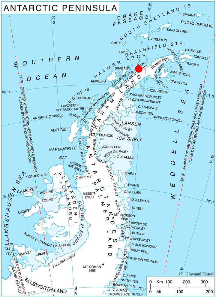
 Tumba Ice Cap ( bg, ледник Тумба, lednik Tumba, ) is the ice cap covering the western half of
Antarctic Digital Database (ADD).
Scale 1:250000 topographic map of Antarctica. Scientific Committee on Antarctic Research (SCAR), 1993–2016.
Bulgarian Antarctic Gazetteer.
basic data
in English)
SCAR Composite Gazetteer of Antarctica
Tumba Ice Cap.
Copernix satellite image Ice caps of Antarctica Bodies of ice of Graham Land Bulgaria and the Antarctic Davis Coast {{Glaciology-stub
Chavdar Peninsula
Chavdar Peninsula ( bg, полуостров Чавдар, poluostrov Chavdar, ) is a 10-km wide peninsula projecting 13 km in northwest direction from Graham Land on the Antarctic Peninsula in Antarctica. It is bounded by Curtiss Bay to the nort ...
on the west side of Graham Land
Graham Land is the portion of the Antarctic Peninsula that lies north of a line joining Cape Jeremy and Cape Agassiz. This description of Graham Land is consistent with the 1964 agreement between the British Antarctic Place-names Committee and ...
, Antarctic Peninsula
The Antarctic Peninsula, known as O'Higgins Land in Chile and Tierra de San Martín in Argentina, and originally as Graham Land in the United Kingdom and the Palmer Peninsula in the United States, is the northernmost part of mainland Antarctic ...
. It is situated west of Samodiva Glacier
Chavdar Peninsula ( bg, полуостров Чавдар, poluostrov Chavdar, ) is a 10-km wide peninsula projecting 13 km in northwest direction from Graham Land on the Antarctic Peninsula in Antarctica. It is bounded by Curtiss Bay to the nort ...
, extending 7.7 km in east–west direction and 4 km in north–south direction, and draining both northwards into Curtiss Bay
Curtiss Bay () is a bay about wide, indenting the west coast of Graham Land just north of the Chavdar Peninsula, and entered between Cape Sterneck and Cape Andreas on the Davis Coast. Its head is fed by Samodiva Glacier, Pirin Glacier and Tumb ...
and southwards into Hughes Bay
Hughes Bay is a bay lying between Cape Sterneck and Cape Murray along the west coast of the Antarctic Peninsula. It is wide and lies south of Chavdar Peninsula and north of Pefaur (Ventimiglia) Peninsula, indenting the Danco Coast on the west si ...
The geographic feature is named after the peak of Tumba in Belasitsa Mountain, Southwestern Bulgaria.
Location
Tumba Ice Cap is centred at .British
British may refer to:
Peoples, culture, and language
* British people, nationals or natives of the United Kingdom, British Overseas Territories, and Crown Dependencies.
** Britishness, the British identity and common culture
* British English, ...
mapping in 1978.
Maps
* British Antarctic Territory. Scale 1:200000 topographic map. DOS 610 Series, Sheet W 64 60. Directorate of Overseas Surveys, Tolworth, UK, 1978.Antarctic Digital Database (ADD).
Scale 1:250000 topographic map of Antarctica. Scientific Committee on Antarctic Research (SCAR), 1993–2016.
References
Bulgarian Antarctic Gazetteer.
Antarctic Place-names Commission
The Antarctic Place-names Commission was established by the Bulgarian Antarctic Institute in 1994, and since 2001 has been a body affiliated with the Ministry of Foreign Affairs of Bulgaria.
The Commission approves Bulgarian place names in ...
. (details in Bulgarianbasic data
in English)
SCAR Composite Gazetteer of Antarctica
External links
Tumba Ice Cap.
Copernix satellite image Ice caps of Antarctica Bodies of ice of Graham Land Bulgaria and the Antarctic Davis Coast {{Glaciology-stub