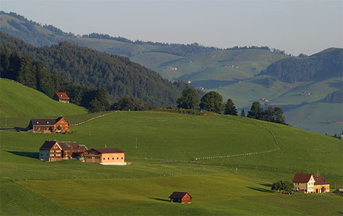
Streusiedlung on:
[Wikipedia]
[Google]
[Amazon]
 A dispersed settlement, also known as a scattered settlement, is one of the main types of settlement patterns used by
 A dispersed settlement, also known as a scattered settlement, is one of the main types of settlement patterns used by
 landscape historians
A landscape is the visible features of an area of land, its landforms, and how they integrate with natural or man-made features, often considered in terms of their aesthetic appeal.''New Oxford American Dictionary''. A landscape includes the p ...
to classify rural settlements found in England and other parts of the world. Typically, there are a number of separate farmsteads scattered throughout the area. A dispersed settlement contrasts with a nucleated village. It can be known as main human settlements.
The French term '' bocage'' is sometimes used to describe the type of landscape found where dispersed settlements are common.
In addition to Western Europe, dispersed patterns of settlement are found in parts of Papua New Guinea, as among the Gainj, Ankave, and Baining tribes. It is also frequently met with in nomadic pastoral societies.
In Ghana, Kumbyili in the northern region is also an example of a dispersed settlement
England
In England, dispersed settlements are often found in the areas of ancient enclosure outside the central region—for example, Essex, Kent and the West Country. An example of a dispersed settlement given by W G Hoskins is Middle Barton inSteeple Barton
Steeple Barton is a civil parish and scattered settlement on the River Dorn in West Oxfordshire, about east of Chipping Norton, a similar distance west of Bicester and south of Banbury. Most of the parish's population lives in the village of ...
, Oxfordshire
Oxfordshire is a ceremonial and non-metropolitan county in the north west of South East England. It is a mainly rural county, with its largest settlement being the city of Oxford. The county is a centre of research and development, primarily ...
.
In some parts of England, the pattern of dispersed settlement has remained unchanged for many hundreds of years. Many of the locations found in Domesday
Domesday Book () – the Middle English spelling of "Doomsday Book" – is a manuscript record of the "Great Survey" of much of England and parts of Wales completed in 1086 by order of King William I, known as William the Conqueror. The manusc ...
may be dispersed farmsteads. It is sometimes possible to identify documentary references to farmsteads in the 18th and 19th centuries with these Domesday entries.
In areas of Kent and Essex close to London, the development of residential housing during the 20th century has often disguised the dispersed nature of the original settlement.
The farmsteads which make up the dispersed settlement are often surrounded by small irregularly shaped fields. Traditionally, trees are encouraged to grow at the edges of these fields and in thin strips alongside roads. However, during the 20th century, much of this woodland disappeared, either as a result of disease or modern farming practice. Arthur Young's description of the view from Langdon Hills, "dark lanes intersected with numberless hedges and woods," is a typical description of the landscape in an area of dispersed settlements.
Italy
Anthony Galt has written an extensive study of the dispersed settlement pattern around Locorotondo in the Province of Bari in southern Italy.D. Curtis, https://www.academia.edu/1933250/Is_there_an_agro-town_model_for_Southern_Italy_Exploring_the_diverse_roots_and_development_of_the_agro-town_structure_through_a_comparative_case_study_in_Apulia In this case, the settlement pattern developed because of movement from the town to the countryside in the 19th century. Emphyteutic leases were used by landowners seeking to increase their income from land that was only marginally attractive for agriculture by encouraging the creation of vineyards.German-speaking Europe
Known as ''Streusiedlungen'' (singular ''Streusiedlung''), dispersed settlements are a characteristic of various parts of German-speaking Europe, including in areas of Westphalia, historically theRuhr
The Ruhr ( ; german: Ruhrgebiet , also ''Ruhrpott'' ), also referred to as the Ruhr area, sometimes Ruhr district, Ruhr region, or Ruhr valley, is a polycentric urban area in North Rhine-Westphalia, Germany. With a population density of 2,800/km ...
urban area (the dispersed settlements lending themselves to the development of urban sprawl after industrialisation), the Austro-Bavarian parts of the Alps ( Upper Bavaria, Austria, South Tyrol) as well as Alamanni
The Alemanni or Alamanni, were a confederation of Germanic tribes
*
*
*
on the Upper Rhine River. First mentioned by Cassius Dio in the context of the campaign of Caracalla of 213, the Alemanni captured the in 260, and later expanded into pres ...
c parts of the Alps ( Bernese Oberland, Central Switzerland).
Notes
{{DEFAULTSORT:Dispersed Settlement Landscape history