St Gennys on:
[Wikipedia]
[Google]
[Amazon]


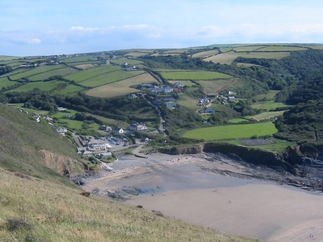
 St Gennys () is a coastal
GENUKI website: St Gennys. Retrieved May 2010 The arcades of the aisles are partly in


 St Gennys () is a coastal
 civil parish
In England, a civil parish is a type of administrative parish used for local government. It is a territorial designation which is the lowest tier of local government. Civil parishes can trace their origin to the ancient system of parishes, w ...
and small settlement in north Cornwall
Cornwall (; or ) is a Ceremonial counties of England, ceremonial county in South West England. It is also one of the Celtic nations and the homeland of the Cornish people. The county is bordered by the Atlantic Ocean to the north and west, ...
, England, United Kingdom.
The village of St Gennys is about southwest of Bude
Bude (, locally or ; Cornish language, Cornish ) is a seaside town in north Cornwall, England, in the civil parish of Bude-Stratton and at the mouth of the River Neet (also known locally as the River Strat). It was sometimes formerly known as ...
.Ordnance Survey: Landranger map sheet 190 ''Bude & Clovelly'' It is on high ground half-a-mile north of the coastal village of Crackington Haven, the major settlement in the parish. The only other settlements of any size in the parish are Middle Crackington and Higher Crackington both of which are southeast of Crackington Haven, half-a-mile and one mile distant respectively. The population of the parish at the 2011 census was 873.
History and geography
The name St Gennys is generally thought to derive from 4th Century Christian martyr Saint Genesius although it has been suggested that the commemoration is to the Welsh Saint Gwynws. In either case the name is old and several places in the parish are mentioned in theDomesday Book
Domesday Book ( ; the Middle English spelling of "Doomsday Book") is a manuscript record of the Great Survey of much of England and parts of Wales completed in 1086 at the behest of William the Conqueror. The manuscript was originally known by ...
including Crackington (as ''Crachemua''), Dizzard (as ''Disart'') and St Gennys itself (as ''Sainguinas'' or ''Sanwinas'') To the west St Gennys is bounded by the Atlantic
The Atlantic Ocean is the second largest of the world's five oceanic divisions, with an area of about . It covers approximately 17% of Earth's surface and about 24% of its water surface area. During the Age of Discovery, it was known for se ...
coast where Cornwall's highest cliff (appropriately named High Cliff) rises above the rocky foreshore. Cambeak is a prominent headland and the cliffs at the Strangles are a National Trust property. In one year in the 1820s it is believed 23 ships were wrecked on this part of the coast.
The parish, which had a recorded population of 873 in the 2011 census
A census (from Latin ''censere'', 'to assess') is the procedure of systematically acquiring, recording, and calculating population information about the members of a given Statistical population, population, usually displayed in the form of stati ...
, is in Stratton Registration District and lies within the Cornwall Area of Outstanding Natural Beauty
The Cornwall National Landscape (formerly the Cornwall Area of Outstanding Natural Beauty) covers in Cornwall, England, United Kingdom; that is, about 27% of the total area of the county. It comprises 12 separate areas, designated under the Na ...
(AONB); almost a third of Cornwall has AONB designation with the same status and protection as a National Park. Away from the coast St Gennys parish is entirely rural and is bordered to the north by Poundstock
Poundstock () is a civil parish and a hamlet on the north coast of Cornwall, England, United Kingdom. The hamlet is situated four miles (6.5 km) south of Bude half-a-mile west of the A39 trunk road about one mile from the coast.
Poundstock ...
parish, to the east by Jacobstow
Jacobstow () is a civil parishes in England, civil parish and village in north Cornwall, England, United Kingdom. The village is located east of the A39 road approximately south of Bude.Ordnance Survey: Landranger map sheet 190 ''Bude & Clovel ...
parish, and to the south by Otterham
Otterham () is a village and a civil parish in north Cornwall, England, United Kingdom. The village is situated approximately south of Bude and north of Camelford.Ordnance Survey: Landranger map sheet 190 ''Bude & Clovelly''
Otterham Mill, Ot ...
and St Juliot
St Juliot is a civil parishes in England, civil parish in north-east Cornwall, England, United Kingdom. The parish is entirely rural and the settlements within it are the hamlets of Beeny and Tresparrett. - plus a part of the adjacent village of ...
parishes.
The manor of St Gennys was recorded in the Domesday Book (1086) when it was one of several manors held by Jovin from Robert, Count of Mortain
Robert, Count of Mortain, first Earl of Cornwall of 2nd creation (–) was a Norman nobleman and the half-brother (on their mother's side) of King William the Conqueror. He was one of the very few proven companions of William the Conqueror at t ...
; before 1066 it had been held by Gytha who also held Poundstock. There was half a hide of land and land for 10 ploughs. There were 3 ploughs, 3 serfs, 2 villeins, 8 smallholders, 40 acres of pasture, 7 cattle, 40 sheep and 6 goats. The value of the manor was £1 sterling.
Parish church
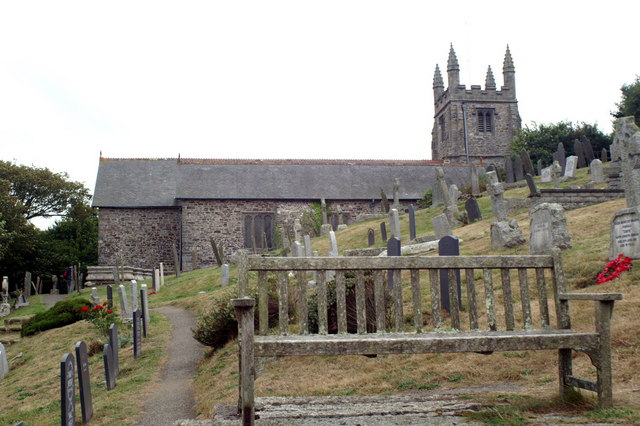
The parish church is situated on a sloping site in St Gennys village at . It is dedicated to Saint Genesius. The building is partlyNorman
Norman or Normans may refer to:
Ethnic and cultural identity
* The Normans, a people partly descended from Norse Vikings who settled in the territory of Normandy in France in the 9th and 10th centuries
** People or things connected with the Norma ...
with a short one-stage tower topped by a pyramidal roof. The tower houses a ring of four bells. The church was restored
''Restored'' is the fourth studio album by American contemporary Christian musician Jeremy Camp. It was released on November 16, 2004, by BEC Recordings.
Track listing
Standard release
Enhanced edition
Deluxe gold edition
Standard Aus ...
in 1871.GENUKI website: St Gennys. Retrieved May 2010 The arcades of the aisles are partly in
granite
Granite ( ) is a coarse-grained (phanerite, phaneritic) intrusive rock, intrusive igneous rock composed mostly of quartz, alkali feldspar, and plagioclase. It forms from magma with a high content of silica and alkali metal oxides that slowly coo ...
and partly in Polyphant stone
Elvan is a name used in Cornwall and Devon for the native varieties of quartz-porphyry. They are dispersed irregularly in the Devonian series of rocks and some of them make very fine building stones (e.g. Pentewan stone, Polyphant stone and Cata ...
.
In 1727 it was recorded that St Gennys vicarage was built of stone and cob; this building was replaced in 1734. George Thomson was vicar of St Gennys for 50 years, from 1732 to 1782. Early in his ministry at St Gennys he experienced dreams which deepened his religious faith. He became acquainted with George Whitefield
George Whitefield (; 30 September 1770), also known as George Whitfield, was an English Anglican minister and preacher who was one of the founders of Methodism and the evangelical movement. Born in Gloucester, he matriculated at Pembroke Coll ...
who came to preach at St Gennys more than once. Thomson did not restrict his ministry to his own parish but also preached in nearby parishes until he was admonished by the bishop for doing so.
Notable residents
Laurence Braddon (died 1724), was an English politician and writer, the second son of William Braddon of Treworgy in St Gennys.References
Further reading
* Berry, Christopher (2002). ''The Church in St Gennys''. * The St Gennys GazetteExternal links
{{DEFAULTSORT:Saint Gennys Villages in Cornwall Civil parishes in Cornwall Manors in Cornwall