Squally on:
[Wikipedia]
[Google]
[Amazon]
A squall is a sudden, sharp increase in wind speed lasting minutes, as opposed to a wind gust, which lasts for only seconds. They are usually associated with active weather, such as rain showers, thunderstorms, or heavy snow. Squalls refer to the increase of the sustained winds over that time interval, as there may be higher gusts during a squall event. They usually occur in a region of strong sinking air or cooling in the mid-atmosphere. These force strong localized upward motions at the leading edge of the region of cooling, which then enhances local downward motions just in its wake.
Names of Winds.
/ref>
Guide To Singapore's Weather, archived by archive.org on November 1, 2013.
/ref>
 A '' squall line'' is an organized line of thunderstorms. It is classified as a multi-cell cluster, meaning a thunderstorm complex comprising many individual updrafts. They are also called multi-cell lines. Squalls are sometimes associated with hurricanes or other
 Wind shear is an important aspect to measuring the potential of squall line severity and duration. In low to medium shear environments, mature thunderstorms will contribute modest amounts of downdrafts, enough to turn will aid in create a leading edge lifting mechanism – the gust front. In high shear environments created by opposing low level jet winds and synoptic winds, updrafts and consequential downdrafts can be much more intense (common in supercell mesocyclones). The cold air
 The poleward end of the squall line is commonly referred to as the cyclonic end, with the equatorward side rotating anticyclonically. Because of the
Storm Spotter Online Training.
Retrieved on 2006-11-19. From the time these low cloud features appear in the sky, one can expect a sudden increase in the wind in less than 15 minutes.
Etymology
There are different versions of the word's origins: * By one version, the word appears to be Nordic in origin, but its etymology is considered obscure. It probably has its roots in the word ''skvala'' an Old Norse word meaning literally ''to squeal''. * By another version, it is an alteration of ''squeal'' influenced by ''bawl''.Character of the wind
The term "squall" is used to refer to a sudden wind-speed increase lasting minutes. In 1962 the World Meteorological Organization (WMO) defined that to be classified as a "squall", the wind must increase at least 8 m/s and must attain a top speed of at least 11 m/s, lasting at least one minute in duration. In Australia, a squall is defined to last for several minutes before the wind returns to the long-term mean value. In either case, a squall is defined to last about half as long as the definition of sustained wind in its respective country. Usually, this sudden violent wind is associated with briefly heavy precipitation as squall line.Regional terms
Argentina
Known locally as ''pamperos'', these are characterized as strong downsloped winds that move across the pampas, eventually making it to the Atlantic Ocean.Central America
Offshore Central America, a ''gully squall'' is characterized by strong increases of the wind forced through sharp mountain valleys on the Pacific Ocean side of the isthmus.Cuba
A ''bayamo'' is a squall emanating from tropical thunderstorms near the Bight of Bayamo.East Indies
In the East Indies, ''brubu'' is a name for a squallPacific Northwest (North America)
In the Pacific Northwest, a ''squall'' is a short but furious rainstorm with strong winds, often small in area and moving at high speed, especially as a maritime term. A strongKatabatic
A katabasis or catabasis ( grc, κατάβασις, from "down" and "go") is a journey to the underworld. Its original sense is usually associated with Greek mythology and Classical mythology more broadly, where the protagonist visits the Gre ...
outflow occurring in fjords and inlets is referred to by mariners as a '' squamish''.
South Africa
''Bull's Eye Squall'' is a term used offshore South Africa for a squall forming in fair weather. It is named for the appearance of the small isolated cloud marking the top of the squall.Golden Gate Weather ServicesNames of Winds.
/ref>
Philippines (West Pacific)
In most parts of the country, squalls are called ''subasko'' and are characterized by heavy rains driven by blustery winds. Local fishermen at sea are often on the lookout for signs of impending squalls on the open water and rush to shore at its early signs.South-East Asia
"Barat" is a term for a northwest squall in Manado Bay inSulawesi
Sulawesi (), also known as Celebes (), is an island in Indonesia. One of the four Greater Sunda Islands, and the world's eleventh-largest island, it is situated east of Borneo, west of the Maluku Islands, and south of Mindanao and the Sulu Ar ...
.
"Sumatra
Sumatra is one of the Sunda Islands of western Indonesia. It is the largest island that is fully within Indonesian territory, as well as the sixth-largest island in the world at 473,481 km2 (182,812 mi.2), not including adjacent i ...
" squall is a term used in Singapore and Peninsular Malaysia for squall lines that form over the island of Sumatra
Sumatra is one of the Sunda Islands of western Indonesia. It is the largest island that is fully within Indonesian territory, as well as the sixth-largest island in the world at 473,481 km2 (182,812 mi.2), not including adjacent i ...
and move east across the Straits of Malacca
The Strait of Malacca is a narrow stretch of water, 500 mi (800 km) long and from 40 to 155 mi (65–250 km) wide, between the Malay Peninsula (Peninsular Malaysia) to the northeast and the Indonesian island of Sumatra to the southwest, connec ...
. Gusts can reach up to 28 m/s (100 km/h).National Environment AgencGuide To Singapore's Weather, archived by archive.org on November 1, 2013.
/ref>
Severe weather
 A '' squall line'' is an organized line of thunderstorms. It is classified as a multi-cell cluster, meaning a thunderstorm complex comprising many individual updrafts. They are also called multi-cell lines. Squalls are sometimes associated with hurricanes or other
 cyclone
In meteorology, a cyclone () is a large air mass that rotates around a strong center of low atmospheric pressure, counterclockwise in the Northern Hemisphere and clockwise in the Southern Hemisphere as viewed from above (opposite to an anti ...
s, but they can also occur independently. Most commonly, independent squalls occur along front lines
''Front Lines'' is a 1994 computer wargame for MS-DOS developed and published by Impressions Games.
Gameplay
''Front Lines'' is a wargame with a turn-based play system, using vehicles.
Reception
In ''PC Gamer US'', William R. Trotter calle ...
, and may contain heavy precipitation, hail
Hail is a form of solid precipitation. It is distinct from ice pellets (American English "sleet"), though the two are often confused. It consists of balls or irregular lumps of ice, each of which is called a hailstone. Ice pellets generally fal ...
, frequent lightning, dangerous straight line winds, and possibly funnel clouds, tornadoes and waterspout
A waterspout is an intense columnar vortex (usually appearing as a funnel cloud, funnel-shaped cloud) that occurs over a body of water. Some are connected to a cumulus congestus cloud, some to a cumuliform cloud and some to a cumulonimbus clou ...
s. Squall lines require significant low-level warmth and humidity, a nearby frontal zone, and vertical wind shear from an angle behind the frontal boundary. The strong winds at the surface are usually a reflection of dry air intruding into the line of storms, which when saturated, falls quickly to ground level due to its much higher density before it spreads out downwind. Significant squall lines with multiple bow echoes are known as derechos.
Squall line life cycle
There are several forms of mesoscale meteorology, including simplistic isolated thunderstorms unrelated to advancing cold fronts, to the more complex daytime/nocturnal mesoscale convective system (MCS) and mesoscale convective complex (MCC), to squall line thunderstorms.Formation
The main driving force behind squall line creation is attributed to the process of in-filling of multiple thunderstorms and/or a single area of thunderstorms expanding outward within the leading space of an advancing cold front.=Pressure perturbations
= Pressure perturbations within an extent of a thunderstorm are noteworthy. With buoyancy rapid within the lower and mid-levels of a mature thunderstorm, one might believe that low pressure dominates in the mesoscale environment. However, this is not the case. With downdrafts ushering colder air from mid-levels, hitting ground and propagating away in all directions, high pressure is to be found widely at surface levels, usually indicative of strong (potentially damaging) winds.=Wind shear
= Wind shear is an important aspect to measuring the potential of squall line severity and duration. In low to medium shear environments, mature thunderstorms will contribute modest amounts of downdrafts, enough to turn will aid in create a leading edge lifting mechanism – the gust front. In high shear environments created by opposing low level jet winds and synoptic winds, updrafts and consequential downdrafts can be much more intense (common in supercell mesocyclones). The cold air
 outflow
Outflow may refer to:
*Capital outflow, the capital leaving a particular economy
*Bipolar outflow, in astronomy, two continuous flows of gas from the poles of a star
*Outflow (hydrology), the discharge of a lake or other reservoir system
* Outflow ...
leaves the trailing area of the squall line to the mid-level jet, which aids in downdraft processes.
Evolution
=Updrafts
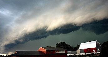
= The leading area of a squall line is composed primarily of multiple updrafts, or singular regions of an updraft, rising from ground level to the highest extensions of the troposphere, condensing water and building a dark, ominous cloud to one with a noticeable overshooting top and anvil (thanks to synoptic scale winds). Because of the chaotic nature of updrafts and downdrafts, pressure perturbations are important. As thunderstorms fill into a distinct line, strong leading-edge updrafts – occasionally visible to a ground observer in the form of ashelf cloud
An arcus cloud is a low, horizontal cloud formation, usually appearing as an accessory cloud to a cumulonimbus. Roll clouds and shelf clouds are the two main types of arcus clouds. They most frequently form along the leading edge or gust fronts ...
– may appear as an ominous sign of potential severe weather.
Beyond the strong winds because of updraft/downdraft behavior, heavy rain (and hail
Hail is a form of solid precipitation. It is distinct from ice pellets (American English "sleet"), though the two are often confused. It consists of balls or irregular lumps of ice, each of which is called a hailstone. Ice pellets generally fal ...
) is another sign of a squall line. In the winter, squall lines can occur albeit less frequently – bringing heavy snow and/or thunder and lightning – usually over inland lakes (i.e. Great Lakes region).
=Bow echoes
= Following the initial passage of a squall line, light to moderatestratiform
Stratiform may refer to:
* Any of the stratus family of clouds (fog, stratus clouds, altostratus clouds, cirrostratus clouds, nimbostratus clouds) and the precipitation coming from them.
* Any occurrence of layered strata (see stratigraphic unit). ...
precipitation is also common. A bow echo is frequently seen on the northern and southernmost reaches of squall line thunderstorms (via satellite imagery). This is where the northern and southern ends curl backwards towards the middle portions of the squall line, making a "bow" shape. Bow echoes are frequently featured within supercell mesoscale systems.
=Mesolow
= The poleward end of the squall line is commonly referred to as the cyclonic end, with the equatorward side rotating anticyclonically. Because of the
 coriolis force
In physics, the Coriolis force is an inertial or fictitious force that acts on objects in motion within a frame of reference that rotates with respect to an inertial frame. In a reference frame with clockwise rotation, the force acts to the ...
, the poleward end may evolve further, creating a "comma shaped" mesolow, or may continue in a squall-like pattern.
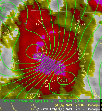
A wake low is another kind of mesoscale low-pressure area to the rear of a squall line near the back edge of the stratiform rain area. Due to the subsiding warm air associated with the system's formation, clearing skies are associated with the wake low. Severe weather, in the form of high winds, can be generated by the wake low when the pressure difference between the mesohigh preceding it and the wake low is intense enough.. When the squall line is in the process of decay, heat burst
In meteorology, a heat burst is a rare atmospheric phenomenon characterized by a sudden, localized increase in air temperature near the Earth's surface. Heat bursts typically occur during night-time and are associated with decaying thunderstorm ...
s can be generated near the wake low. Once new thunderstorm activity along the squall line concludes, the wake low associated with it weakens in tandem.
Dissipation
As supercells and multi-cell thunderstorms dissipate due to a weak shear force or poor lifting mechanisms, (e.g. considerable terrain or lack of daytime heating) the squall line or gust front associated with them may outrun the squall line itself and the synoptic scale area of low pressure may then infill, leading to a weakening of the cold front; essentially, the thunderstorm has exhausted its updrafts, becoming purely a downdraft dominated system. The areas of dissipating squall line thunderstorms may be regions of low CAPE, low humidity, insufficient wind shear, or poor synoptic dynamics (e.g. an upper-level low filling) leading to frontolysis. From here, a general thinning of a squall line will occur: with winds decaying over time, outflow boundaries weakening updrafts substantially and clouds losing their thickness.Signs in the sky
Shelf clouds and roll clouds are usually seen above the leading edge of a squall, also known as a thunderstorm's gust front.National Weather Service Forecast Office, Springfield, MissouriStorm Spotter Online Training.
Retrieved on 2006-11-19. From the time these low cloud features appear in the sky, one can expect a sudden increase in the wind in less than 15 minutes.
Tropical cyclones
Tropical cyclones normally have squalls coincident with spiral bands of greater curvature than many mid-latitude systems due to their smaller size. These squalls can harborwaterspouts
A waterspout is an intense columnar vortex (usually appearing as a funnel-shaped cloud) that occurs over a body of water. Some are connected to a cumulus congestus cloud, some to a cumuliform cloud and some to a cumulonimbus cloud. In the com ...
and tornadoes due to the significant vertical wind shear which exists in the vicinity of a tropical cyclone's outer bands.
Winter weather
Snow squalls
A snowsquall, or snow squall, is a sudden moderately heavy snowfall with blowing snow and strong, gusty surface winds. It is often referred to as a whiteout and is similar to a blizzard but is localized in time or in location and snow accumulat ...
can be spawned by an intrusion of cold air aloft over a relatively warm surface layer. Lake-effect snow
Lake-effect snow is produced during cooler atmospheric conditions when a cold air mass moves across long expanses of warmer lake water. The lower layer of air, heated up by the lake water, picks up water vapor from the lake and rises up through ...
s can be in the form of a snow squall.
See also
* Rogue wave * Squall line *White squall
A white squall is a sudden and violent windstorm at sea which is not accompanied by the black clouds generally characteristic of a squall. It manifests as a sudden increase in wind velocity in tropical and sub-tropical waters, and may be a mic ...
References
{{Authority control Storm Wind Rain