Raymond Fault on:
[Wikipedia]
[Google]
[Amazon]
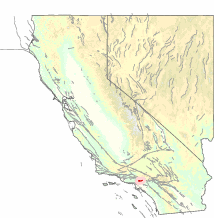
 The Raymond Fault is a fault across central
Southern California Earthquake Data Center: Raymond Fault
USGS Earthquake Hazards Program database: Raymond Fault
{{California Faults Seismic faults of California Geology of Los Angeles County, California Geology of Ventura County, California Natural history of the Santa Monica Mountains Natural history of the Transverse Ranges Natural history of Los Angeles County, California Natural history of Ventura County, California Channel Islands of California Geography of the San Fernando Valley Geography of the San Gabriel Valley
 The Raymond Fault is a fault across central
 Los Angeles County
Los Angeles County, officially the County of Los Angeles and sometimes abbreviated as LA County, is the most populous county in the United States, with 9,663,345 residents estimated in 2023. Its population is greater than that of 40 individua ...
and western Ventura County
Ventura County () is a county located in the southern part of the U.S. state of California. As of the 2020 census, the population was 843,843. The largest city is Oxnard, and the county seat is the city of Ventura.
Ventura County comprises ...
in Southern California
Southern California (commonly shortened to SoCal) is a geographic and Cultural area, cultural List of regions of California, region that generally comprises the southern portion of the U.S. state of California. Its densely populated coastal reg ...
.
San Gabriel Valley area
The eastern end of the Raymond Fault branches from theSan Andreas Fault
The San Andreas Fault is a continental Fault (geology)#Strike-slip faults, right-lateral strike-slip transform fault that extends roughly through the U.S. state of California. It forms part of the tectonics, tectonic boundary between the Paci ...
in the San Gabriel Mountains
The San Gabriel Mountains () are a mountain range located in Los Angeles and San Bernardino counties, California, United States. The mountain range is part of the Transverse Ranges and lies between the Los Angeles Basin and the Mojave Desert ...
where it forms the east fork of the San Gabriel River and Monrovia
Monrovia () is the administrative capital city, capital and largest city of Liberia. Founded in 1822, it is located on Cape Mesurado on the Atlantic Ocean, Atlantic coast and as of the 2022 census had 1,761,032 residents, home to 33.5% of Liber ...
Canyon. The fault is very straight and follows a WbS path. It then goes straight west through Arcadia and the Santa Anita Racetrack
Santa Anita Park is a Thoroughbred racetrack in Arcadia, California, United States. It offers some of the prominent horse racing events in the United States during early fall, winter and in spring. The track is home to numerous prestigious races ...
in the San Gabriel Valley
The San Gabriel Valley (), sometimes referred to by its initials as SGV, is one of the principal valleys of Southern California, with the city of Los Angeles directly bordering it to the west and occupying the vast majority of the southeastern ...
, and then forms the San Rafael Hills in San Marino
San Marino, officially the Republic of San Marino, is a landlocked country in Southern Europe, completely surrounded by Italy. Located on the northeastern slopes of the Apennine Mountains, it is the larger of two European microstates, microsta ...
and South Pasadena, and Raymond Hill, after which the fault is named.
Los Angeles–Ventura areas
The fault continues west to form the hills of Highland Park, the lower eastern Santa Monica Mountains fromDodger Stadium
Dodger Stadium is a ballpark in the Elysian Park neighborhood of Los Angeles, California, United States. It is the home of the Los Angeles Dodgers of Major League Baseball (MLB). Opened in 1962, it was constructed in less than three years at a ...
, Silver Lake, and Griffith Park through the Hollywood Hills above the Sunset Strip and Studio City. Further west the Raymond Fault creates the higher central and western Santa Monica Mountains from Beverly Hills
Beverly Hills is a city located in Los Angeles County, California, United States. A notable and historic suburb of Los Angeles, it is located just southwest of the Hollywood Hills, approximately northwest of downtown Los Angeles. Beverly Hil ...
and along the southern San Fernando Valley
The San Fernando Valley, known locally as the Valley, is an urbanized valley in Los Angeles County, Los Angeles County, California. Situated to the north of the Los Angeles Basin, it comprises a large portion of Los Angeles, the Municipal corpo ...
to Thousand Oaks and Malibu, and on to Point Mugu at the Pacific Ocean
The Pacific Ocean is the largest and deepest of Earth's five Borders of the oceans, oceanic divisions. It extends from the Arctic Ocean in the north to the Southern Ocean, or, depending on the definition, to Antarctica in the south, and is ...
. The fault then continues underwater to form the northern Channel Islands
The Channel Islands are an archipelago in the English Channel, off the French coast of Normandy. They are divided into two Crown Dependencies: the Jersey, Bailiwick of Jersey, which is the largest of the islands; and the Bailiwick of Guernsey, ...
, and beyond to where it terminates.
References
External links
Southern California Earthquake Data Center: Raymond Fault
USGS Earthquake Hazards Program database: Raymond Fault
{{California Faults Seismic faults of California Geology of Los Angeles County, California Geology of Ventura County, California Natural history of the Santa Monica Mountains Natural history of the Transverse Ranges Natural history of Los Angeles County, California Natural history of Ventura County, California Channel Islands of California Geography of the San Fernando Valley Geography of the San Gabriel Valley