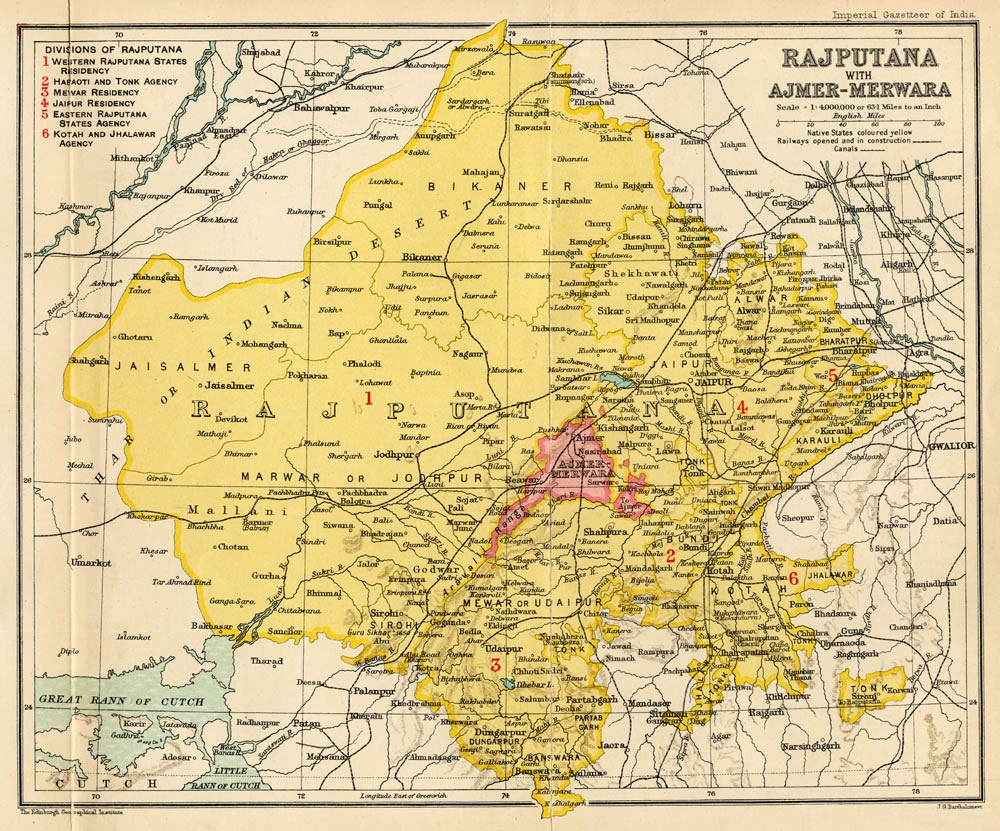
Rajputana on:
[Wikipedia]
[Google]
[Amazon]

 Rājputana, meaning "Land of the Rajputs", was a region in the

 Rājputana, meaning "Land of the Rajputs", was a region in the
 Indian subcontinent
The Indian subcontinent is a physiographical region in Southern Asia. It is situated on the Indian Plate, projecting southwards into the Indian Ocean from the Himalayas. Geopolitically, it includes the countries of Bangladesh, Bhutan, India ...
that included mainly the present-day Indian state
India is a federal union comprising 28 states and 8 union territories, with a total of 36 entities. The states and union territories are further subdivided into districts and smaller administrative divisions.
History
Pre-indep ...
of Rajasthan
Rajasthan (; lit. 'Land of Kings') is a state in northern India. It covers or 10.4 per cent of India's total geographical area. It is the largest Indian state by area and the seventh largest by population. It is on India's northwestern s ...
, as well as parts of Madhya Pradesh
Madhya Pradesh (, ; meaning 'central province') is a state in central India. Its capital city, capital is Bhopal, and the largest city is Indore, with Jabalpur, Ujjain, Gwalior, Sagar, Madhya Pradesh, Sagar, and Rewa, India, Rewa being the othe ...
and Gujarat
Gujarat (, ) is a state along the western coast of India. Its coastline of about is the longest in the country, most of which lies on the Kathiawar peninsula. Gujarat is the fifth-largest Indian state by area, covering some ; and the nin ...
, and some adjoining areas of Sindh
Sindh (; ; ur, , ; historically romanized as Sind) is one of the four provinces of Pakistan. Located in the southeastern region of the country, Sindh is the third-largest province of Pakistan by land area and the second-largest province ...
in modern-day southern Pakistan.
The main settlements to the west of the Aravalli Hills came to be known as ''Rajputana'', early in the Medieval Period. The name was later adopted by British government
ga, Rialtas a Shoilse gd, Riaghaltas a Mhòrachd
, image = HM Government logo.svg
, image_size = 220px
, image2 = Royal Coat of Arms of the United Kingdom (HM Government).svg
, image_size2 = 180px
, caption = Royal Arms
, date_est ...
as the Rajputana Agency for its dependencies in the region of the present-day India
India, officially the Republic of India ( Hindi: ), is a country in South Asia. It is the seventh-largest country by area, the second-most populous country, and the most populous democracy in the world. Bounded by the Indian Ocean on the ...
n state of Rājasthān. The Rajputana Agency included 18 princely states, two chiefships and the British district of Ajmer-Merwara
Ajmer-Merwara, also known as Ajmir Province and as Ajmer-Merwara-Kekri, was a former province of British India in the historical Ajmer region. The territory was ceded to the British by Daulat Rao Sindhia by a treaty on 25 June 1818.
It was u ...
. This British official term remained until its replacement by "Rajasthan" in the constitution of 1949.
Name
George Thomas (''Military Memories'') was the first in 1800, to term this region the ''Rajputana Agency''. The historianJohn Keay
John Stanley Melville Keay FRGS is a British historian, journalist, radio presenter and lecturer specialising in popular histories of India, the Far East and China, often with a particular focus on their colonisation and exploration by Europe ...
in his book, ''India: A History'', stated that the ''Rajputana'' name was coined by the British, but that the word achieved a retrospective authenticity: in an 1829 translation of Ferishta's history of early Islamic India, John Briggs discarded the phrase "Indian princes", as rendered in Dow's earlier version, and substituted "Rajpoot princes".
The region was previously long known as Gujratra (an early form of "Gujarat"), before it came to be called Rajputana during the medieval period, although the name "Gujratra" itself originated from Gujara Parthihar .
Geography
The area of Rajputana is estimated to be 343,328 square km (132,559 square miles) and breaks down into two geographic divisions: * An area northwest of the Arāvalli Range including part of the Great Indian Thar Desert, with characteristics of being sandy and unproductive. * A higher area southeast of the range, which is fertile by comparison. The whole area forms the hill and plateau country between the north Indian plains and the main plateau of peninsular India.Princely States Region
* Kingdom of Marwar *Shekhawati State
Shekhawati is a semi-arid historical region located in the northeast part of Rajasthan, India. The region was ruled by Shekhawat Rajputs.
Shekhawati is located in North Rajasthan, comprising the districts of Jhunjhunu,
parts of Sikar that lies ...
* Kingdom of Mewar
*Jaipur State
Jaipur State was a princely state in India during East India Company rule and thereafter under the British Raj. It signed a treaty creating a subsidiary alliance with the Company in 1818, after the Third Anglo-Maratha War. It acced ...
*Sirohi State
Kingdom of Sirohi or later Sirohi State (in colonial time) was an independent Hindu state in present-day Rajasthan state of India. The state was founded in 1311 CE and lasted for six centuries until its peaceful dissolution in 1949 CE, when ...
* Vagad State
* Mewat State
Rise of Rajasthan
History
Notes
References
#Low, Sir Francis (ed.) ''The Indian Year Book & Who’s Who 1945-46'', The Times of India Press, Bombay. #Sharma, Nidhi ''Transition from Feudalism to Democracy'', Aalekh Publishers, Jaipur, 2000 . #vikas raghav would have been a rich boy today,if his ancestors did not donate all his land to sc st people History of India History of Rajasthan History of Madhya Pradesh History of Gujarat History of Pakistan {{Rajasthan-geo-stub